


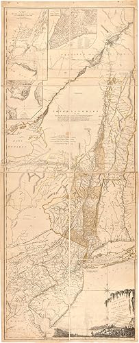
THE PROVINCES OF NEW YORK, AND NEW JERSEY; WITH PART OF PENSILVANIA [sic], AND THE PROVINCE OF QUEBEC. DRAWN BY MAJOR HOLLAND, SURVEYOR GENERAL, OF THE NORTHERN DISTRICT IN AMERICA. CORRECTED AND IMPROVED, FROM THE ORIGINAL MATERIALS, BY GOVERN.R POWNALL, MEMBER OF PARLIAMENT, 1776
Holland, Samuel
Published by Printed for Robt. Sayer and John Bennett, August 17, London, 1776
Used
From
William Reese Company - Americana, New Haven, CT, U.S.A.
Seller rating 4 out of 5 stars
![]()
AbeBooks Seller since July 13, 2006
This specific copy is no longer available. Here are our closest matches for THE PROVINCES OF NEW YORK, AND NEW JERSEY; WITH PART OF PENSILVANIA [sic], AND THE PROVINCE OF QUEBEC. DRAWN BY MAJOR HOLLAND, SURVEYOR GENERAL, OF THE NORTHERN DISTRICT IN AMERICA. CORRECTED AND IMPROVED, FROM THE ORIGINAL MATERIALS, BY GOVERN.R POWNALL, MEMBER OF PARLIAMENT, 1776 by Holland, Samuel.
About this Item
Description:
Engraved map consisting of eight folio sheets backed on linen (54 1/2 x 21 3/4 inches), with contemporary color outlining and shading of some boundaries and geographic features. Slightly soiled, occasional minor stains, a few old repairs (no loss of text). In a brown cloth slipcase. A very good copy. This famous map is one of the best for the provinces of New York and New Jersey during the colonial period. It is the fourth state described by McCorkle, following versions published circa 1768, in 1775, and earlier in 1776. "The map includes western Connecticut and Massachusetts and most of Vermont. In 1775 the title became 'The Provinces of New York, and New Jersey; with part of Pensilvania, and the Province of Quebec'.Three insets were added in this state: A chart of the mouth of the Hudson River; A plan of the City of New York; Plan of Amboy.The following year the date changed to 1776. Later in the same year the title was extended to include 'Corrected and improved, from the original materials, by Govern.r Pownall' and Holland's rank was given as Major" - McCorkle. The present copy is the final version described by McCorkle. THE PROVINCES OF NEW YORK, AND NEW JERSEY is in effect a large-scale map of the Hudson River and its tributaries, including the Mohawk, and settlement in New York is almost entirely confined to the banks of the Hudson and Mohawk rivers. The unexplored Adirondack County is left almost entirely blank, with a lengthy notation that begins, "Beaver Hunting Country of the Confederated Indians." Pennsylvania extends north into western New York state almost as far as the Mohawk, Vermont is shown attached to New York (with each existing township identified), and the map extends north into Quebec beyond Montreal. Interesting notations on the country are scattered across the face of the map. For instance, in Pennsylvania, an area with little detail is simply noted as "endless mountains." The map is beautifully decorated, with a pastoral title cartouche suggestive of the Hudson Palisades in the lower right corner. The map was created by Samuel Holland, Surveyor General for the Northern District of North America. As a result of the French and Indian War (1755-63), Great Britain had acquired a new American Empire, for which there were few adequate maps. Two new offices of surveyor general for the American colonies were established in 1763-64. The colonies were divided at the Potomac River into a northern and southern district, and the respective surveyors appointed were Samuel Holland and Gerard De Brahm. Holland conceived of a general survey of North America east of the Mississippi to be based upon geodetic principles, on a scale of one inch to one mile, but work was interrupted in 1775 by the outbreak of the American Revolution. A very good copy of Holland's large and important map which includes western New England and portions of Quebec. DEGREES OF LATITUDE, fig. 21. PHILLIPS ATLASES 1166, number 17. McCORKLE 768.3, 775.6, 776.13. Seller Inventory # WRCAM36226
Bibliographic Details
Title: THE PROVINCES OF NEW YORK, AND NEW JERSEY; ...
Publisher: Printed for Robt. Sayer and John Bennett, August 17, London
Publication Date: 1776
Top Search Results from the AbeBooks Marketplace

THE PROVINCES OF NEW YORK, AND NEW JERSEY; WITH PART OF PENSILVANIA [sic], AND THE PROVINCE OF QUEBEC. DRAWN BY MAJOR HOLLAND, SURVEYOR GENERAL, OF THE NORTHERN DISTRICT IN AMERICA. CORRECTED AND IMPROVED, FROM THE ORIGINAL MATERIALS, BY GOVERN.R POWNALL, MEMBER OF PARLIAMENT, 1776.
Published by
London: Printed for Robt. Sayer and John Bennett, August 17, 1776., 1776
Used
Seller: William Reese Company - Americana, New Haven, CT, U.S.A.
Seller rating 4 out of 5 stars
![]()
This famous map is one of the best for the provinces of New York and New Jersey during the colonial period. It is the fourth state described by McCorkle, following versions published circa 1768, in 1775, and earlier in 1776. "The map includes western Connecticut and Massachusetts and most of Vermont. In 1775 the title became 'The Provinces of New York, and New Jersey; with part of Pensilvania, and the Province of Quebec'.Three insets were added in this state: A chart of the mouth of the Hudson River; A plan of the City of New York; Plan of Amboy.The following year the date changed to 1776. Later in the same year the title was extended to include 'Corrected and improved, from the original materials, by Govern.r Pownall' and Holland's rank was given as Major" - McCorkle. The present copy is the final version described by McCorkle. THE PROVINCES OF NEW YORK, AND NEW JERSEY is in effect a large-scale map of the Hudson River and its tributaries, including the Mohawk, and settlement in New York is almost entirely confined to the banks of the Hudson and Mohawk rivers. The unexplored Adirondack County is left almost entirely blank, with a lengthy notation that begins, "Beaver Hunting Country of the Confederated Indians." Pennsylvania extends north into western New York state almost as far as the Mohawk, Vermont is shown attached to New York (with each existing township identified), and the map extends north into Quebec beyond Montreal. Interesting notations on the country are scattered across the face of the map. For instance, in Pennsylvania, an area with little detail is simply noted as "endless mountains." The map is beautifully decorated, with a pastoral title cartouche suggestive of the Hudson Palisades in the lower right corner. The map was created by Samuel Holland, Surveyor General for the Northern District of North America. As a result of the French and Indian War (1755-63), Great Britain had acquired a new American Empire, for which there were few adequate maps. Two new offices of surveyor general for the American colonies were established in 1763-64. The colonies were divided at the Potomac River into a northern and southern district, and the respective surveyors appointed were Samuel Holland and Gerard De Brahm. Holland conceived of a general survey of North America east of the Mississippi to be based upon geodetic principles, on a scale of one inch to one mile, but work was interrupted in 1775 by the outbreak of the American Revolution. A very good copy of Holland's large and important map which includes western New England and portions of Quebec. DEGREES OF LATITUDE, fig. 21. PHILLIPS, ATLASES 1166, number 17. McCORKLE 768.3, 775.6, 776.13. Engraved map consisting of eight folio sheets backed on linen (54� x 21� inches), with contemporary color outlining and shading of some boundaries and geographic features. Slightly soiled, occasional minor stains, a few old repairs (no loss of text). In a brown cloth slipcase. A very good copy. Seller Inventory # 36226
Quantity: 1 available