
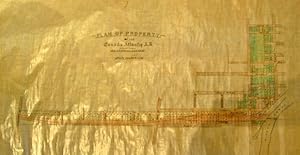
Plan of Property. -of the Canada Atlantic R.R. and Promoters Thereof. Scale 200 feet to 1 inch. Manuscript Map. On coated linen, in black & two colours, Plan includes from east west Gilmour, Argyle, Catharine and Isabella Streets., and from north to south; the Rideau Canal at Pretoria Bridge, Cartier, Elgin, Metcalfe, O'Connor, Bank to Concession Street. (Bronson ?). Lots are numbered
MAP]. [Ottawa Manuscript Property Map]
Published by Nd. [1890/1900?]
Condition: Used - Fine
Sold by J. Patrick McGahern Books Inc. (ABAC), Ottawa, ON, Canada
Association Member:
Heritage Bookseller
AbeBooks Seller since May 29, 1997
Seller rating 4 out of 5 stars
![]()
Used
Condition: Used - Fine
Price:
US$ 548.41
US$ 10.00 shipping
Ships from Canada to U.S.A.
Ships from Canada to U.S.A.
Quantity: 1 available
Add to basket