


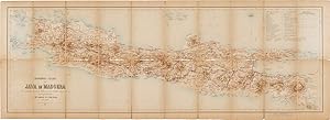
SPOORWEG-KAART VAN JAVA EN MADOERA MET AANDUIDING DER OVERIGE HOOFDCOMMUNICATIE MIDDELEN TE LAND EN TER ZEE. TE SAMENGESTELD DOOR J.W. STEMFOORT EN J. HORA ADEMA
[Indonesia]
Published by Jos. Smulders and Co., [The Hague], 1885
Used
From
William Reese Company - Americana, New Haven, CT, U.S.A.
Seller rating 4 out of 5 stars
![]()
AbeBooks Seller since July 13, 2006
This specific copy is no longer available. Here are our closest matches for SPOORWEG-KAART VAN JAVA EN MADOERA MET AANDUIDING DER OVERIGE HOOFDCOMMUNICATIE MIDDELEN TE LAND EN TER ZEE. TE SAMENGESTELD DOOR J.W. STEMFOORT EN J. HORA ADEMA by [Indonesia].
About this Item
Description:
Folding map, 16 1/2 x 45 1/2 inches. Backed on linen. Moderate age-toning and dusting, particularly at outer margins. Slight paper loss along center fold and upper and lower outer margins of vertical folds. British mapseller's label pasted below printed map and advertisements ("Stanford's Maps" and "Stanford's Atlases") pasted on two separate panels of verso. A very good copy. In original open-ended slipcase, 8 1/2 x 5 inches, with original British mapseller's paper printed label on front. Case moderately soiled and worn with some chipping. A finely printed color road map of the islands of Java and Madura, published in the Hague in 1885. This copy was distributed by London mapseller Edward Stanford, "sole agent by appointment for the sale of ordnance maps," whose labels are found on the storage box and below the printed map and whose advertisements are on the map's verso. The map by J. W. Stemfoort and J. Hora Adema is scaled 1:1,000,000, with topographic elements shown in relief by shading with spot heights indicated. Major and secondary roads, railroad and tramways, and ferry routes along the coasts are indicated. OCLC 63613975. Seller Inventory # WRCAM38258
Bibliographic Details
Title: SPOORWEG-KAART VAN JAVA EN MADOERA MET ...
Publisher: Jos. Smulders and Co., [The Hague]
Publication Date: 1885
Top Search Results from the AbeBooks Marketplace

SPOORWEG-KAART VAN JAVA EN MADOERA MET AANDUIDING DER OVERIGE HOOFDCOMMUNICATIE MIDDELEN TE LAND EN TER ZEE. TE SAMENGESTELD DOOR J.W. STEMFOORT EN J. HORA ADEMA.
Published by
[The Hague]: Jos. Smulders and Co., 1885., 1885
Used
Seller: William Reese Company - Americana, New Haven, CT, U.S.A.
Seller rating 4 out of 5 stars
![]()
A finely printed color road map of the islands of Java and Madura, published in the Hague in 1885. This copy was distributed by London mapseller Edward Stanford, "sole agent by appointment for the sale of ordnance maps," whose labels are found on the storage box and below the printed map and whose advertisements are on the map's verso. The map by J. W. Stemfoort and J. Hora Adema is scaled 1:1,000,000, with topographic elements shown in relief by shading with spot heights indicated. Major and secondary roads, railroad and tramways, and ferry routes along the coasts are indicated. OCLC 63613975. Folding map, 16½ x 45½ inches. Backed on linen. Moderate age-toning and dusting, particularly at outer margins. Slight paper loss along center fold and upper and lower outer margins of vertical folds. British mapseller's label pasted below printed map and advertisements ("Stanford's Maps" and "Stanford's Atlases") pasted on two separate panels of verso. A very good copy. In original open-ended slipcase, 8½ x 5 inches, with original British mapseller's paper printed label on front. Case moderately soiled and worn with some chipping. Seller Inventory # 38258
Quantity: 1 available