
Scotia regnum divisum in Partem Septentrionalem et Meridionalem.
Wit, de Frederick ( 1610 - 1698 ) Amsterdam
Published by Artist: Wit de Frederick ( - 1698 ) Amsterdam issued in: Amsterdam; - Frederik de Wit (1610 ? 1698) His Atlas began to appear around 1662 and by 1671 included anywhere from 17 to 151 maps each In the 1690s he began to use a new title page "Atlas Maior" but continued to use his old title page His atlas of the Low Countries first published in 1667was named Nieuw Kaertboeck van de XVII Nederlandse Provinciën and contained 14 to 25 maps Frederik de Wit quickly expanded upon his first small folio atlas which contained mostly maps printed from plates that he had acquired to an atlas with 27 maps engraved by or for him By 1671 he was publishing a large folio atlas with as many as 100 maps Smaller atlases of 17 or 27 or 51 maps could still be purch, 1610
Used
From
Antique Sommer& Sapunaru KG, München, Germany
Seller rating 2 out of 5 stars
![]()
AbeBooks Seller since May 13, 2015
This specific copy is no longer available. Here are our closest matches for Scotia regnum divisum in Partem Septentrionalem et Meridionalem. by Wit, de Frederick ( 1610 - 1698 ) Amsterdam.
About this Item
Description:
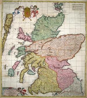
Technic: Copper print, colorit: original colored, condition: Upper and lower center restored, missing parts replaced, 3 margins enlarged, size (in cm): 57 x 50,5 cm; - Map shows total Scotia with beautiful heraldics. Seller Inventory # EUG2477_500
Bibliographic Details
Title: Scotia regnum divisum in Partem ...
Publisher: Artist: Wit de Frederick ( - 1698 ) Amsterdam issued in: Amsterdam; - Frederik de Wit (1610 ? 1698) His Atlas began to appear around 1662 and by 1671 included anywhere from 17 to 151 maps each In the 1690s he began to use a new title page "Atlas Maior" but continued to use his old title page His atlas of the Low Countries first published in 1667was named Nieuw Kaertboeck van de XVII Nederlandse Provinciën and contained 14 to 25 maps Frederik de Wit quickly expanded upon his first small folio atlas which contained mostly maps printed from plates that he had acquired to an atlas with 27 maps engraved by or for him By 1671 he was publishing a large folio atlas with as many as 100 maps Smaller atlases of 17 or 27 or 51 maps could still be purch
Publication Date: 1610
Top Search Results from the AbeBooks Marketplace

Seller Image
Scotia regnum divisum in Partem Septentrionalem et Meridionalem.
Seller: Antique Sommer& Sapunaru KG, München, Germany
Seller rating 2 out of 5 stars
![]()
Technic: Copper print, colorit: original coloredcondition: Upper and lower center restored, missing parts replaced, 3 margins enlarged, size (in cm): 57 x 50,5 cm; - Map shows total Scotia with beautiful heraldics. Seller Inventory # EUG2477
Quantity: 1 available