About this Item
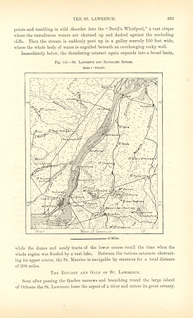
THE ST LAWRENCE AND RICHELIEU RIVERS,CANADA ,Antique Historical Relief Map THE ST LAWRENCE AND RICHELIEU RIVERS,CANADA 1893 WOOD ENGRAVED HISTORICAL MAPAntique Topographical Map CLOSEUP . Approx Image Size : 4 1/2 X 5 inches Approx Overall Size: 7 X 10 1/2 inches Scale : 1: 700,000, The Saint Lawrence River (French: fleuve Saint-Laurent) is a large west-to-east flowing river in the middle latitudes of North America, connecting the Great Lakes with the Atlantic Ocean. It is called Kaniatarowanenneh ("big waterway") in Mohawk. It traverses the Canadian province of Quebec and forms part of the border between the state of New York in the United States and the province of Ontario in Canada. The Saint Lawrence River is born at the outflow of Lake Ontario at Kingston, Ontario. From there, it passes Brockville, Cornwall, Montreal, Trois-Rivières, and Quebec City before draining into the Gulf of Saint Lawrence, the largest estuary in the world. It runs 3,058 kilometers (1,900 miles) from the furthest headwater to the mouth (1,197 km or 744 miles from the outflow of Lake Ontario). The furthest headwater is the North River, Mesabi Range, Minnesota. Its drainage area, which includes the Great Lakes and hence the world's largest system of fresh water lakes, has a size of 1.03 million km . The average discharge at the mouth is 10,400 m /s. The river includes Lac Saint-Louis south of Montreal, Lac Saint-François at Salaberry-de-Valleyfield, Quebec and Lac Saint-Pierre east of Montreal. It surrounds such islands as the Thousand Islands near Kingston, the Island of Montreal, Île Jésus (Laval), Île d'Orléans near Quebec City, and Anticosti Island north of the Gaspé. Lake Champlain and the Ottawa, Richelieu, and Saguenay rivers drain into the St. Lawrence. The first European to navigate the St. Lawrence was Jacques Cartier, who on 9 June 1534 first sighted the river and also claimed New France for Francis I. Until the early 1600s, the French used the name Rivière du Canada to designate the Saint Lawrence upstream to Montreal and the Ottawa River after Montreal. The Saint Lawrence River served as the main route for exploration of the North American interior from Europe. The St. Lawrence was formerly continuously navigable only as far as Montreal due to the Lachine Rapids. The Lachine Canal was the first to allow ships to pass the rapids; the Saint Lawrence Seaway, an extensive system of canals and locks, now permits ocean-going vessels to pass all the way to Lake Superior. The Richelieu River in Quebec, Canada flows about 130 km north to drain Lake Champlain into the St. Lawrence River at Sorel. St. Jean, Chambly, and Sorel are important communities on its route. The French explorer Samuel de Champlain was the first European to reach the mouth of the river in 1609. Already an important pathway for the Iroquois Indians, it soon became one for French traders as well. They built forts along its length: Fort Richelieu at its mouth, Fort St. Louis (or Chambly), Fort Ste. Thérese and Fort St. Jean on the way, and Fort Ste. Anne on the Isle La Motte in Lake Champlain near its source. Some early journals and maps refer to the lower river as the Sorel River. (wikipedia), CONDITION: BOOKPLATE INTEXT MAP - Excellent Condition. Map Image is clean, clear, sharp with beautiful detail. As scanned. There is TEXT ON BACK SIDE. I prefer paypal or money orders. Delivery time for items can be anywhere from 10-28 days depending on your location. Items will be shipped within 2 business days of payment received. Checks will need time to clear before items are sent.
Seller Inventory # 8346
Contact seller
Report this item