
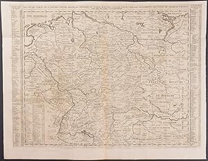
Map of German Empire extending from the Netherlands and the Baltic to Austria and Switzerland (Nouvelle Carte de l'empire Divise Selon ses Differents Etats� �.)
Henri Abraham Chatelain
Published by Amsterdam, 1718
Used
From
Trillium Antique Prints & Rare Books, Franklin, TN, U.S.A.
Seller rating 4 out of 5 stars
![]()
AbeBooks Seller since March 6, 2017
This specific copy is no longer available. Here are our closest matches for Map of German Empire extending from the Netherlands and the Baltic to Austria and Switzerland (Nouvelle Carte de l'empire Divise Selon ses Differents Etats….) by Henri Abraham Chatelain.
About this Item
Description:
Henri Abraham Chatelain's Atlas Historique. The work was published by the author in Amsterdam between 1718 and 1720. The text was combiled by Gueudeville & Garillon. The maps were completed by Chatelain some influenced by Guillaume de l'Isle's work. The work was published in several editions, and the second edition was the first to include additional maps not found in the first including a map of the world, Americas, Europe, Asia, and Africa.Atlas Historique was a highly ambitious and groundbreaking work covering genealogy, cosmography, topography, heraldry, and chronology. It was intended for the general public and the increased fascination with the recently conquered colonies and the new discoveries. Chatelain's maps are an outstanding example of the golden age of French mapmaking. --- The work is in very good to excellent condition overall. There may be some faint offset or minor imperfections to be expected with age. Please review the image carefully for condition and contact us with any questions. Seller Inventory # chatelain7-024
Bibliographic Details
Title: Map of German Empire extending from the ...
Publisher: Amsterdam
Publication Date: 1718
Condition: Fine
Top Search Results from the AbeBooks Marketplace

Seller Image
Map of German Empire extending from the Netherlands and the Baltic to Austria and Switzerland (Nouvelle Carte de l'empire Divise Selon ses Differents Etats�.)
Published by
Amsterdam, 1718
Used
First Edition
Seller: Trillium Antique Prints & Rare Books, Franklin, TN, U.S.A.
Seller rating 4 out of 5 stars
![]()
Condition: Fine. This originally hand-colored engraving is from Henri Abraham Chatelain's Atlas Historique. The work was published by the author in Amsterdam between 1718 and 1720.The text was compiled by Gueudeville & Garillon. The maps were completed by Chatelain with some influenced by Guillaume de l'Isle's work.The work was published in several editions with the second edition the first to include additional maps not found in the first including a map of the world, Americas, Europe, Asia, and Africa. These engravings come from mixed editions. Those from volumes 5 to 7 are first edition. The engravings from volumes 1 to 4 are from early ediitons.Atlas Historique was a highly ambitious and groundbreaking work covering genealogy, cosmography, topography, heraldry, and chronology. It was intended for the general public and the increased fascination with the recently conquered colonies and the new discoveries. Chatelain's maps are an outstanding example of the golden age of French mapmaking. --- The work is in good to excellent condition overall. There can be occasional offset, toning, or some separation to fold out plates. There may be a few minor imperfections or faint marks to be expected with age. Please review the image carefully for condition and contact us with any questions. --- Paper Size ~ 25 1/2" by 21 1/2" (Fold Out). Seller Inventory # chatelain02-024
Quantity: 1 available