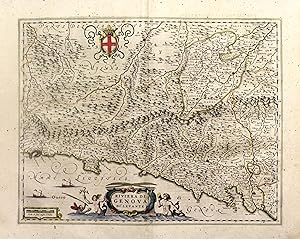
Riviera di Genova di Levante
BLAEU JOAN
Sold by libreria antiquaria perini Sas di Perini, Verona, VR, Italy
Association Member:
AbeBooks Seller since September 18, 2006
Used
Quantity: 1 available
Add to basketSold by libreria antiquaria perini Sas di Perini, Verona, VR, Italy
Association Member:
AbeBooks Seller since September 18, 2006
Quantity: 1 available
Add to basketIncisione in rame, mm 385x510, testo latino al verso. Elegante e piacevole carta del Levante ligure, arricchita da cartigli, navi e stemmi. Ottimo esemplare perfettamente conservata anche se lievemente ingiallita. W. Blaeu, astronomo allievo di Tycho Brahe, fondÚ un'officina per la costruzione di globi nel 1599; quasi immediatamente iniziÚ a pubblicare anche carte geografiche, giungendo nel 1630 alla creazione del primo atlante "Atlantis Appendix" e cinque anni dopo, della prima edizione in due tomi del "Atlas Novus". Dopo la sua morte nel 1638, a cura del figlio Johan si giunse nel 1662 alla pubblicazione del celebre "Atlas Maior" in 11 volumi. Nel 1672 un incendio distrusse l'officina e segnÚ la fine dell'attivit? Copper engraving, mm 385x510, latin text on verso. Elegant map of the Levante ligure between Genova and Sarzana. Good condition even if slightly discolored. W. Blaeu, born in Alkmaar in 1571, studied astronomy by Tycho Brahe and founded a business in 1599 as a globe and instrument maker. He immediately expanded the business publishing maps and in 1630 the first atlas "Atlantis appendix" and five years later the "Atlas novus". After his death in 1638, his son Joan reached publication of the major work of the family, the "Atlas maior" in 11 volumes. In 1672 a great fire destroyed the Blaeu's printing house. Nr.cat: Cod 3411.
Seller Inventory # 12686
books are sold as described.
Orders are usually shipped within 2 business days unless they require an export licence. Shipping costs are based on weight books. If your order is heavy or oversized, we may contact you to let you know extra shipping is required.