Order Total (1 Item Items):
Shipping Destination:

Blaeu, Willem Jansz (29 results)
Skip to main search results
Product Type
- All Product Types
- Books (24)
- Magazines & Periodicals
- Comics
- Sheet Music
- Art, Prints & Posters
- Photographs
- Maps (5)
-
Manuscripts &
Paper Collectibles
Condition
Binding
Collectible Attributes
Free Shipping
Seller Location
Seller Rating
-
![Seller image for Guilielmi Blaeu Institutio astronomica de usu globorum & sphaerarum caelestium ac terrestrium duabus partibus adornata, una, secundum hypothesin Ptolemaei, per terram quiescientem. Altera, juxta mentem N. Copernici, per terram mobilem. Latine reddita a M. Hortensio . [LeatherBound] for sale by True World of Books](https://pictures.abebooks.com/inventory/md/md31533318040.jpg)
Guilielmi Blaeu Institutio astronomica de usu globorum & sphaerarum caelestium ac terrestrium duabus partibus adornata, una, secundum hypothesin Ptolemaei, per terram quiescientem. Altera, juxta mentem N. Copernici, per terram mobilem. Latine reddita a M. Hortensio . [LeatherBound]
Publication Date: 2023
Book Print on Demand
LeatherBound. Condition: New. LeatherBound edition. Condition: New. Reprinted from 1652 edition. Leather Binding on Spine and Corners with Golden leaf printing on spine. Bound in genuine leather with Satin ribbon page markers and Spine with raised gilt bands. A perfect gift for your loved ones. NO changes have been made to the original text. This is NOT a retyped or an ocr'd reprint. Illustrations, Index, if any, are included in black and white. Each page is checked manually before printing. As this print on demand book is reprinted from a very old book, there could be some missing or flawed pages, but we always try to make the book as complete as possible. Fold-outs, if any, are not part of the book. If the original book was published in multiple volumes then this reprint is of only one volume, not the whole set. Sewing binding for longer life, where the book block is actually sewn (smythe sewn/section sewn) with thread before binding which results in a more durable type of binding. Pages: 273 Language: Latin.
-
![Seller image for Guilielmi Blaeu Institutio astronomica de usu globorum & sphaerarum caelestium ac terrestrium duabus partibus adornata, una, secundum hypothesin Ptolemaei, per terram quiescentem. Altera, juxta mentem N. Copernici, per terram mobilem. Latine reddita a M. Hortensio, . (1640) [LeatherBound] for sale by True World of Books](https://pictures.abebooks.com/inventory/md/md31657326248.jpg)
Guilielmi Blaeu Institutio astronomica de usu globorum & sphaerarum caelestium ac terrestrium duabus partibus adornata, una, secundum hypothesin Ptolemaei, per terram quiescentem. Altera, juxta mentem N. Copernici, per terram mobilem. Latine reddita a M. Hortensio, . (1640) [LeatherBound]
Publication Date: 2023
Book Print on Demand
LeatherBound. Condition: New. LeatherBound edition. Condition: New. Reprinted from 1640 edition. Leather Binding on Spine and Corners with Golden leaf printing on spine. Bound in genuine leather with Satin ribbon page markers and Spine with raised gilt bands. A perfect gift for your loved ones. NO changes have been made to the original text. This is NOT a retyped or an ocr'd reprint. Illustrations, Index, if any, are included in black and white. Each page is checked manually before printing. As this print on demand book is reprinted from a very old book, there could be some missing or flawed pages, but we always try to make the book as complete as possible. Fold-outs, if any, are not part of the book. If the original book was published in multiple volumes then this reprint is of only one volume, not the whole set. Sewing binding for longer life, where the book block is actually sewn (smythe sewn/section sewn) with thread before binding which results in a more durable type of binding. Pages: 280 Willem Jansz Blaeu.
-

De wereld volgens Blaeu. Blaeu's wereldkaarten op groot formaat uit 1646.
Seller: Antiquariaat A. Kok & Zn. B.V., Amsterdam, Netherlands
Seller Rating:

Rotterdam, MAritiem museum 'Prins Hendrik', 1986. 62 pp. B./w. ills. Softcover. Square 8vo.Description of Willem Jansz. 1646 wallmap of the world.
-
![Seller image for Institution astronomique de l'usage des globes et spheres celestes et terrestres 1669 [LeatherBound] for sale by True World of Books](https://pictures.abebooks.com/inventory/md/md31616595436.jpg)
Institution astronomique de l'usage des globes et spheres celestes et terrestres 1669 [LeatherBound]
Publication Date: 2023
Book Print on Demand
LeatherBound. Condition: New. LeatherBound edition. Condition: New. Reprinted from edition. Leather Binding on Spine and Corners with Golden leaf printing on spine. Bound in genuine leather with Satin ribbon page markers and Spine with raised gilt bands. A perfect gift for your loved ones. NO changes have been made to the original text. This is NOT a retyped or an ocr'd reprint. Illustrations, Index, if any, are included in black and white. Each page is checked manually before printing. As this print on demand book is reprinted from a very old book, there could be some missing or flawed pages, but we always try to make the book as complete as possible. Fold-outs, if any, are not part of the book. If the original book was published in multiple volumes then this reprint is of only one volume, not the whole set. Sewing binding for longer life, where the book block is actually sewn (smythe sewn/section sewn) with thread before binding which results in a more durable type of binding. Pages: 307.
-
![Seller image for Le flambeau de la navigation, monstrant la discipline et delineation de toutes les cartes et havres de la mer occidentale, septentrionale et orientale 1620 [LeatherBound] for sale by True World of Books](https://pictures.abebooks.com/inventory/md/md31617360066.jpg)
LeatherBound. Condition: New. LeatherBound edition. Condition: New. Reprinted from edition. Leather Binding on Spine and Corners with Golden leaf printing on spine. Bound in genuine leather with Satin ribbon page markers and Spine with raised gilt bands. A perfect gift for your loved ones. NO changes have been made to the original text. This is NOT a retyped or an ocr'd reprint. Illustrations, Index, if any, are included in black and white. Each page is checked manually before printing. As this print on demand book is reprinted from a very old book, there could be some missing or flawed pages, but we always try to make the book as complete as possible. Fold-outs, if any, are not part of the book. If the original book was published in multiple volumes then this reprint is of only one volume, not the whole set. Sewing binding for longer life, where the book block is actually sewn (smythe sewn/section sewn) with thread before binding which results in a more durable type of binding. Pages: 481.
-
The world map of 1624 by Willem Jansz. Blaeu & Jodocus Hondius.
Seller: Antiquariaat A. Kok & Zn. B.V., Amsterdam, Netherlands
Seller Rating:
Amsterdam, Nico Israel, 1977. 17 pp. B./w. text ills & 20 b./w. plts. Orig. softcover (green printed wrappers). Folio.Including a full size facsimile of the Blaeu / Hondius worldmap of 1624 [overall size 165 x 244 cm]. - Edition limited to 600 copies.
-
Willem Janszoon Blaeu. Nova et accurata Germaniae tabula (Amsterdam 1612).
Seller: Antiquariaat A. Kok & Zn. B.V., Amsterdam, Netherlands
Seller Rating:
Alphen a./d. Rijn, 1995. 62 pp. 43 b./w. ills (incl. fullpage maps) & 11 single-page b./w. plts. Hardcover. Large folio. (Cartographica Rarissima. Collection T. Niewodniczanski. - Vol. 2).Including a large full size facsimile in black and white of Blaeu's Germaniae wallmap of 1612.
-
Alphen aan den Rijn, Uitgeverij "Canaletto", 1993. 1 vol. (of 2). 23 b./w. maps & views on [37] loose sheets, together in orig. large blue cloth portfolio with gilt lettering. Oblong folio.Only the plate volume with 23 fulls size reproductions of maps by Willem Jansz. Blaeu: 2 views of navle battles (each on 3 sheets), 2 worlmaps (2 different states, each on 2 sheets), 16 bifolio maps, a panorama of Amsterdam (on 4 sheets) and Venice (on 5 sheets) and a map of the Beemster (on 2 sheets). - The text volume is not present !! - - Please note: of the world map in two parts by Blaeu from 1604 (map 3A in this work), only the left part is included in facsimile (3A.1). This is a reprint of the left part of this world map that is present in the UB Erlangen-N�rnberg. To date, no copy of the right part of the original 1604 Blaeu edition of this world map is known. Map 3A.2 is therefore not missing in this edition. It has never been included in this edition.
-
Lo gouvernement de l�Isle de France [Mapa]
Published by Blaeu, s.l, sa [Amsterdam, ca 1640], 1640
Seller: MIQUELEIZ ANTIGUEDADES, PAMPLONA, Spain
Seller Rating:
Condition: Bueno. Grabado sobre cobre, 42x51 cm. (huella), iluminado y con puntos de oro. Cartela barroca. Texto en castellano en el verso. Huellas de humedad y coloros algo corridos, papel tostado, rasgadura en parte superior. Francia Cartograf�a.
-
The light of navigation.
Seller: Antiquariaat A. Kok & Zn. B.V., Amsterdam, Netherlands
Seller Rating:
At Amsterdam, Printed by William Iohnson, 1612 [reprint Amsterdam, N. Israel, Publisher / Meridian Publishing Co., 1964]. 2 vols in 1. XIII,[58],114,[1], 118,[1] pp. B./w. ills, incl. 41 fold. charts. Rebound in modern hardcover binding (brown linen with gilt title). Oblong. 4to. - Lacking dust jacket. (Theatrum orbis terrarum. 1st. series, vol. 6). Facsimile edition of Blaeu's "The Light of Navigation. [Wherein are lively pourtrayed all the coasts and Havens of the West, North and East Seas .]" (Amsterdam, 1612), the English edition of Blaeu's "Het licht der zee-vaert" (1608). - With an introduction (biographical note) by R.A. Skelton.
-
Monumenta Cartographica Neerlandica IV. Losse kaarten en topografische prenten uitgegeven door Willem Jansz. Blaeu. / Single-sheet maps and topographical prints pubished by Willem Jansz Blaeu.
Book
Alphen aan den Rijn, Canaletto, 1993.Un volume reli� in folio (28,5 x 39 cm) de 364 pages. Reliure pleine toile d'�diteur, titrage dor� au dos et sur le premier plat. Exemplaire en bon �tat. Il s'agit du volume de texte explicatif des fac-simil�s de cartes qui sont r�unis dans un autre volume que nous ne poss�dons pas. Les cartes sont quand m�me ici reproduites en petit format et en noir et blanc. Livres.
-
Carte du Bourdelois, du pais de Medoc et de la prevost� de Born [Mapa]
Published by Blaeu, s.l, sa [Amsterdam, ca 1635], 1635
Seller: MIQUELEIZ ANTIGUEDADES, PAMPLONA, Spain
Seller Rating:
Condition: Bueno. Grabado sobre cobre, 40x23 cm. (huella), iluminado parcialmente, puntos de oro. Cartela barroca. Texto en castellano en el verso. Huella de humedad en punta superior derecha. Francia Cartograf�a.
-
The light of navigation.
Seller: Antiquariaat A. Kok & Zn. B.V., Amsterdam, Netherlands
Seller Rating:
At Amsterdam, Printed by William Iohnson, 1612 [reprint Amsterdam, N. Israel, Publisher / Meridian Publishing Co., 1964]. 2 vols in 1. XIII,[58],114,[1], 118,[1] pp. B./w. ills, incl. 41 fold. charts. Orig. hardcover (gilt letterd gray cloth). Oblong 4to. - Laking the dust jacket; hinges sl. weak. (Theatrum Orbis Terrarum. Series of atlases in facsimile, First series, Vol. 6). Facsimile edition of Blaeu's "The Light of Navigation. [Wherein are lively pourtrayed all the coasts and Havens of the West, North and East Seas .]" (Amsterdam, 1612), the English edition of Blaeu's "Het licht der zee-vaert" (1608). - With an introduction (biographical note) by R.A. Skelton.
-
Monumenta Cartographica Neerlandica V. Tien wandkaarten van Blaeu en Visscher / Ten Wall Maps by Blaeu and Visscher. [Complete two volume set].
Seller: Antiquariaat A. Kok & Zn. B.V., Amsterdam, Netherlands
Seller Rating:
Alphen aan den Rijn, Uitgeverij "Canaletto", 1996. 2 vols. Vol. 1 (text vol.): [II],384 pp. 371 b./w. ills. Orig. hardcover (publisher's large blue cloth binding with gilt lettering and vignette on front boards). Sm. folio. - [AND:] vol. 2 (plate vol.): 10 b./w. wall maps (in actual size) on [145] loose leaves (not 142 as indicated), together in orig. matching large blue cloth portfolio with gilt lettering. Oblong folio.Complete set of volume five. - The portfolio contains full size reprints of ten wall maps of the four continents, Germany, Italy, Flanders and parts of the Netherlands, all published by Willem Jansz. Blaeu and the Visscher family. - Text in Dutch & English.
-
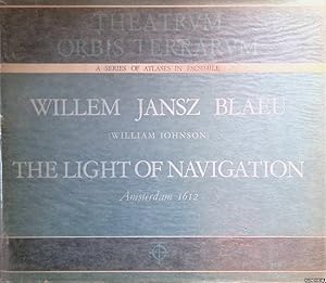
The Light of Navigation - Amsterdam 1612
Published by Amsterdam : Theatrum Orbis Terrarum Limited, 1964
Book
Condition: Good. Original gilt lettered cloth, oblong, ca. 31x27cm, dust jacket, (foldable) illustrations in b/w. Theatrvm Orbis Terrarvm, Series of Facsimile Atlases, First Series, Volume VI.; Small damaged dust jacket repaired; book plate on upper pastedown.
-
The light of navigation.
Seller: Antiquariaat A. Kok & Zn. B.V., Amsterdam, Netherlands
Seller Rating:
At Amsterdam, Printed by William Iohnson, 1612 [reprint Amsterdam, N. Israel, Publisher / Meridian Publishing Co., 1964]. 2 vols in 1. XIII,[58],114,[1], 118,[1] pp. B./w. ills, incl. 41 fold. charts. Orig. hardcover (gilt letterd gray cloth). Oblong 4to. - Laking the dust jacket. (Theatrum Orbis Terrarum. Series of atlases in facsimile, First series, Vol. 6). Facsimile edition of Blaeu's "The Light of Navigation. [Wherein are lively pourtrayed all the coasts and Havens of the West, North and East Seas .]" (Amsterdam, 1612), the English edition of Blaeu's "Het licht der zee-vaert" (1608). - With an introduction (biographical note) by R.A. Skelton.
-
Alphen aan den Rijn, Uitgeverij "Canaletto", 1993. 2 vols. Vol. 1: (text vol.): [IV],364 pp. 326 b./w. ills & maps. Orig. hardcover (publisher's large blue cloth binding with gilt lettering and vignette on front boards). Sm. folio. - [AND:] vol. 2 (plate vol.): 23 b./w. maps & views on [37] loose sheets, together in orig. matching large blue cloth portfolio with gilt lettering. Oblong folio.Complete set of the rather rare fourth volume of the series. - Text in Dutch & English. - Including 23 fulls size reproductions: 2 views of navle battles (each on 3 sheets), 2 worlmaps (2 different states, each on 2 sheets), 16 bifolio maps, a panorama of Amsterdam (on 4 sheets) and Venice (on 5 sheets) and a map of the Beemster (on 2 sheets). - - Please note: of the world map in two parts by Blaeu from 1604 (map 3A in this work), only the left part is included in facsimile (3A.1). This is a reprint of the left part of this world map that is present in the UB Erlangen-N�rnberg. To date, no copy of the right part of the original 1604 Blaeu edition of this world map is known. Map 3A.2 is therefore not missing in this edition. It has never been included in this edition.
-
THE LIGHT OF NAVIGATION 1612
Published by Theatrum Orbis Terrarum Ltd, Amsterdam, 1964
First Edition
hardback. Condition: Fine. Dust Jacket Condition: Fine. facimile reprint. xiii, [60], 114, 118 s. : illus, maps (41 fold.) port. Fascimile of the first edition printed in English. Theatrum Orbis Terrarum. Series of Atlases in Facsimile. First Series, Volume VI Size: Oblong 4to.
-
Grabado en cobre (37 x 48 cm en hoja de 50 x 62 cm.). Original de W. Blaeu (Amsterdam, 1640) e incluido por su hijo Joan en la edici�n de 1662. Mapa del Ducado de Monferrato, entre Torino y la Riviera. Orientado al Oeste. Dispone de tres cartelas: una ornamental con t�tulo, otra de escala ('Milliaria Italica. Germanica communia') y una tercera con dedicatoria (a Jacobus Backer de Guiljemus Blaeuw). Reverso impreso en franc�s, con el t�tulo: 'Le Duche de Monferrat'. Perfecta conservaci�n, con doble cristal y enmarcado en caoba con doble filete dorado (limoncillo). En lat�n, en franc�s.
-
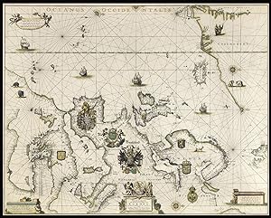
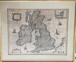
Magnae Britanniae et Hiberniae Tabula - Carte de la Grande-Bretagne et de l'Irlande
Published by Amstelodami - Guiljelmus Blaeuw excudit, 1631
Map
Couverture rigide. Condition: Bon. Magnae Britanniae et Hiberniae Tabula - Carte de la Grande-Bretagne et de l'Irlande (Ecosse, �les britanniques) Cette carte est tir�e du premier atlas mondial du Cartographe Willem Jansz Blaeu (1571-1638). Cette carte a �t� �dit�e en 1630 puis en 1631, il semble que ce soit ici l'une des �ditions de 1631 (l'�dition de 1630 pr�sente des bordures) Dans le cartouche en bas � droite il est indiqu� : Amstelodami - Guiljelmus Blaeuw excudit. Elle a �t� ex�cut�e � partir de la plaque de cuivre achet�e par Blaeu en 1629 � Jodocus Hondius. L'encadrement de bois dor� et la marie-louise sont en bon �tat. sous verre. Frais d'emballage � pr�voir.
-
Map of Gloucestershire. 'GLOCESTRIA DUCATUS; VULGO GLOCESTERSHIRE' Original Colour
Published by Joan Blaeu, Amsterdam, 1645
Map First Edition
Loose Map. Condition: V.g. Original Edition. ND c1645-. 410 x 495mm Double page folding map of the county of Gloucestershire with attractive original hand-colour outline and wash. Nice wide margins and German text to the reverse. One lateral paper crease but no loss. PLEASE EMAIL FOR PHOTOS. Size: Large folio. Printed Map.
-
(Stolen)Tabula Islandiae Auctore Georgio Carolo Flandro
Published by Amsterdam, 1634
Seller: Alexandre Antique Prints, Maps & Books, Toronto, ON, Canada
Seller Rating:

Map
(Stolen)Latin text on verso., Size : 383x504 (mm), 15.125x19.875 (Inches), Hand Colored Very Good; central fold reinforced.
-
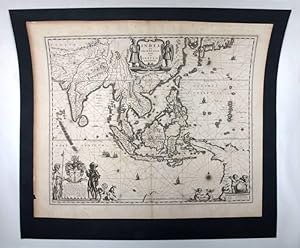
India quae orientalis dicitur, et insulae adiacentes.
Published by Amsterdam, 1640., 1640
Seller: Antiquariat INLIBRIS Gilhofer Nfg. GmbH, Vienna, A, Austria
Association Member: ILAB VDA VDAO
Seller Rating:
Engraved map of Southeast Asia, showing the area from India in the northwest to the southernmost part of Japan in the northeast, with the Indonesian archipelago in the south and an outline of the western part of New Guinea (now part of Indonesia). The areas depicted also include present-day Bangladesh, Myanmar, Thailand, and Vietnam, as well as Cambodia, Malaysia and the Philippines.
-
Lugduni Batavorum Apud Johannem Elzevirium, Academ. Typograph. 1655/ A Amsterdam, chez Jean & Corneille Blaeu, 1642, 2 parties reli�es en 1 volume in-8 de 202x150x45 mm environ, en t�te : Historiae Philosophicae, Georges HORNIUS, 1f.blanc, 8-387 pages, 10ff. (index), (texte en latin) - suivi de : L'Usage des Globes et Spheres, de Willem BLAEU : 18 ff. (titre, pr�face, argument)-277 pages, 1f.blanc, reliure de l'�poque, pleine basane brune, dos � nerfs orn� de caissons � motifs dor�s, tranches mouchet�es de brun et rouge. Quelques rousseurs, une coiffe �br�ch�e, galeries de ver sur un mors et le dernier plat, cuir frott� et �piderm�, sinon bon �tat pour cet important trait� illustr� de figures sur bois dans le texte,notre exemplaire est la traduction originale de ce texte paru pour la premi�re fois en hollandais en 1620. Willem Jansz Blaeu (1571-1638). Janssonius Blaeuw. Imprimeur-libraire et �diteur de cartes et d'atlas. Originaire d'Alkmaar ou des environs. Passe 2 ans aupr�s de Tycho Brah� au Danemark. � son retour � Amsterdam en 1596, s'�tablit cartographe et fabricant de globes terrestres et c�lestes. IL monte ensuite une imprimerie et une fonderie. �galement auteur d'ouvrages cartographiques et astronomiques.
-
Africae nova descriptio.
Published by Joan Blaeu, Amsterdam, 1635
Seller: Antiquariaat Dat Narrenschip, Middelburg, Netherlands
Seller Rating:
Map
No Binding. Condition: Good. Beautifully decorated antique map of Africa. Title and name Willem Blaeu in cartouche top right. The panels on the left show figures from top to bottom in national or regional costume from Morocco, Senegal, Guinea (traders) and Congo, and on the right from Egypt, Ethiopia, Mozambique, Madagascar and inhabitants of the Cape of Good Hope. Above the map are views of nine African cities: Tangier, Ceuta, Algiers, Tunis, Alexandria, Cairo, Mozambique (island), Elmina and Las Palmas de Gran Canaria. Some age toning across the map. A couple of small tears in the margins are repaired on verso. Otherwise good condition. Copper engraving with fabulous old color, published in Amsterdam in 1635 by Joan Blaeu, in 'Theatrum Orbis Terrarum, sive Atlas Novus; in quo Tabulae et Descriptiones omnium Regionum.' Dimensions (picture): 41 x 55 cm.
-
[Atlas of Italy] Guil. et Joannis Blaeu Theatrum Orbis Terrarum, sive Atlas Novus. Pars Tertia
Publication Date: 1645
Seller: Maggs Bros. Ltd ABA, ILAB, PBFA, BA, London, United Kingdom
Association Member: ABA ILAB PBFA
Seller Rating:
Large Folio (500 x 336 mm); engraved title-page with letter-press paste-over; sixtytwo engraved maps, all but one double-page, comprising fifty-eight of Italy and its regions, and four of Greece and regions, including Crete. 18th century mottled calf, seven raised bands, gilt floral tooling and gilt lettering to spine. Both joints split (binding still holding), boards and spine worn, tooling and lettering faded. Amsterdam : Johannes Blaeu, The Blaeu family were the pre-eminent Dutch atlas-publishers of their period. The family published their first terrestrial atlas in 1630, with the multi-volume Atlas Novus launched in 1635. They continued to enlarge the atlas over the next thirty-five years, adding new maps to expand sections, but also preparing separate volumes devoted to England and Wales, Scotland and China. This is the third volume of the Atlas Novus, devoted to Italy, the coverage of that county expanded to almost fill an entire volume, with a small section at the end of Greece. Although not technically an atlas of Italy, the suite of maps relating to Italy and its provinces represents the next geographic advance on Giovanni Antonio Magini?s atlas Italia ., the first separate printed atlas of Italy, first published in 1620 and reissued in 1632. The maps are accompanied by a descriptive geographical text in Latin. Reference: Koeman, BL 37A; the index calls for a section with maps of Scotland and Ireland but this is not, and never was, present, as usual when this volume was issued in the set with the England volume, where the maps were placed.
-
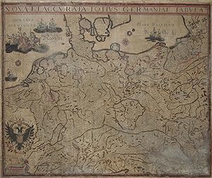
Six sheets joined, mounted on canvas. Canvas size 42 x 50 inches. Hand-colored. Title at top border with "Willem Janss Blaeuw Men Vintse te coop tot Amsterdam op 't Water inde Sonnewyser" placed lower left (paper a bit browned, slight paper loss at edges). Italian edition, first published by Blaeu in 1646. With EXCEEDINGLY RARE HAND-COLORING. Nearly identical in arrangement, decoration, and content to the Blaeu state. Though the Italian copy does not include a reference to publisher or engraver, it likely originated from the Venetian publisher Stefano Scolari, who engraved this copy of "Nova Et Accurata Totius Germaniae Tabula" to use as a model for a complete new set of copperplates. Over the course of his career, Scolari published many copy engravings of decorative wall maps of both Italian and foreign origin during the mid-seventeenth century. ONLY THREE OTHER COPIES OF THIS MAP ARE KNOWN TO SCHILDER ("Monumenta Cartographica Neerlandica") in Augsburg Uni Bibl, Harry Ranson Humanities Research Center of the Uni or Texas (formerly Kraus), and the Niewodnicszanski Collection. Willem Janszoon Blaeu was born at Alkmaar in 1571 and trained in astronomy and the sciences by Tycho Brahe, the celebrated Danish astronomer. In 1599, Blaeu began to make globes and instruments. However, it was not long before the business expanded to include publishing maps, topographical works and books of sea charts. His great skill was recognised by the Dutch East India Company and in 1630 he was appointed their official cartographer, giving him access to the most accurate geographical information available. During his prodigious career Willem Blaeu was to produce several atlases including the Atlantis Appendix of 1630. Five years later, the first two volumes of his planned world atlas, Atlas Novus or the Theatrum Orbis Terrarum were issued. In 1638, Willem Blaeu died and the work was continued by his very capable sons, Joan and Cornelis. Reference: Schilder, Gunter. Monumenta Cartographica Neerlandica. Vol. V. Utrecht University, Holland (pp. 282-289). Catalogued by Annie Morony.
-
Pascaarte van alle de Zee-custen van Europa tot Amsterdam MDCLXXVII, Amsterdam, 1677.
Published by Amsterdam,, 1677
Seller: Daniel Crouch Rare Books Ltd, London, United Kingdom
Association Member: ABA ILAB PBFA
Seller Rating:

Map
A majestic sea chart from the Dutch "Golden Age" probably illuminated by the "Meester Afsetter" Dirk Jansz van Santen Separately published large engraved chart, printed in two sheets on thick paper, joined, with fine contemporary hand-colour lavishly heightened in gold. One of the last maps to bear the Blaeu family imprint and a tour-de-force of the mapmaker's art. An exceptional rarity, and a splendid work of art, the Pascaarte of Europe was the work of the grandsons of Willem Jansz. Blaeu, Pieter and Johannes, and one of the last maps to bear the Blaeu imprint as the chart dates from the period following the fire at the Blaeu family's Gravenstraat premises in Amsterdam in February 1672. A year later Johannes Blaeu I died, and the remaining plate stock was auctioned in 1674 and 1677. The present chart of Europe therefore is one of the few productions from the post-fire period. The chart is an improved re-engraving of the elder Blaeu's 1621 (or later) chart with the same title. No census of the 1677 chart has ever been attempted, but Schilder locates only two examples of the c.1621 pascaarte printed on paper, compared to six on vellum. This is the last in a series of large-scale pascaartes of Europe published from c.1606 by the firm of Blaeu. The charts of 1621 and 1677 extend much further west than the earlier examples, so that they include southern Greenland and the Azores. They also add small compass roses that Cannenberg says "show the magnetic variation on the spot." The 1677 chart improves on the 1621 by extending the coast of Greenland, and correcting the coasts of Iceland, Ireland and other parts of Europe. Illumination One of the greatest treasures from the Golden Age of Dutch cartography is the 19-volume 'Atlas van Hadrianus Relandus' at the Meermanno-Westreenianum Museum in The Hague. Not only does it include many legendary maps and sea charts of the seventeenth century, but, according to Herman de la Fontaine Vervey, "the majestic whole has been coloured leaf by leaf by van Santen with the utmost care, using transparent colours, and with even the tiniest details heightened with gold." He was referring to Dirk Jansz van Santen, the "Meester Afsetter" (master colourist), whose "name was renowned throughout his lifetime and long thereafter, and for whose work there was great demand." Dirk Jansz. van Santen "illuminated and gilded the most prestigious printed works of his time in an exceptionally painterly and brilliant manner. In so doing, he made the Golden Age, quite literally, golden" (Goedings). His clients were the foremost collectors of his age, who often described his art in similarly eulogistic terms. Rarely do maps coloured in van Santen's hand come up for sale; rarer still are maps offered that can be ascribed to him with certainty, as he did not sign the works that he illuminated. The present example can confidently be attributed to the master,as it is coloured in a manner identical to that used for the chart of Southeast Asia by Hendrick Doncker in the Hadrianus Relandus atlas. A note in the Relandus atlas reads "artifex eximinus Theodorus van Santen," and when the atlas came up for sale in 1707, the catalog stated that it was "magnificently coloured by Dirk Jansz van Santen, the equal of Blok." This comparison to Joanna Blok-Koerten was a strong accolade, as she was the seventeenth century Dutch artist most celebrated for fine colouring. Examples from the Relandus atlas of two of the three maps here offered are illustrated in Robert Putnam's 'Early Sea Charts'. Both have pale blue oceans, rich colouring in the decorative vignettes, and the lavish use of gold. The colouring is so alike on the two charts that at first we were concerned that they might be the same work, but close inspection revealed such minor differences as the outline color of Japan on ours it is green; on the Relandus copy it is red - that make it clear that they are in fact different charts coloured by the same hand. Truusje Goedings, author of 'Dirk Jansz. Van Santen a Survey', and acknowledged authority on the works of the master colourist, has examined the present charts and compared them carefully with the maps in the Relandus atlas, and has made the following statement: : "I have examined the two charts at Daniel Crouch Rare Books, and the equivalent charts in the 'Atlas van Hadrianus Relandus' at the Meermanno-Westreenianum Museum in The Hague, and I can confidently conclude that these charts were coloured by the same hand". A copy of her full report on the charts is available on request. Burden, P, 'The Mapping of North America', I, #233 (state II/III); Campbell, T, ' Blaeu's second 'West Indische paskaart' of 1630,' in 'The Map Collector', 30, pp. 36-38; Cannenberg, W. V., 'A Dutch Chart that Survived the Ages', in 'Imago Mundi', IV, pp. 62-63; Fontaine Verwey, Herman de la, 'The Glory of the Blaeu Atlas and the Master Colourist', in Quaerendo XI (1981), pp. 197-229; Keuning &c., 'Willem Janzoon Blaeu', plate 10, & pp. 74-75; Putnam, R., 'Early Sea Charts', plates 27, 41; Schilder, G., 'Monumenta Cartographica Neerlandica', IV, pp.100, 45.1 (first edition, dating 1621 or later) and 114-117, plate 2.53; Schilder, G., 'Willem Janszoon Blaeu's Map of Europe (1606), A Recent Discovery in England', in 'Imago Mundi', 28 (1976), pp. 9-20; Waters, D., 'The Art of Navigation', plate LXXVIII; & p. 327; Zandvliet, K., 'Mapping for Money', plate 9.4, & p. 168-169. See also Keuning, 'Hessel Gerritsz', 'Imago Mundi', VI, 49-66; Goedings, T., 'A Composite Atlas Coloured by Dirk Jansz. Van Santen', pp. 24, 25 (no. 3), 32.
-
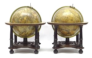
An exceptional pair of Blaeu Table Globes
Published by Amsterdam, Willem Jansz. Blaeu 1602 (published after 1621), 1602
Seller: Antiquariaat de Roo, Zwijndrecht, Netherlands
Seller Rating:
A very rare set of globes, 9 inch / 23cm, with an overall height of 38 cm, Amsterdam, dated 1602, but published after 1621. In their original stands with circular wooden horizon rings, covered with printed paper, supported by four legs and brass meridian rings supported by a single column. The terrestrial and celestial globes are made up of a set of 12 engraved gores, heightened in gold and Arctic ice caps, printed on paper and mounted on a plaster sphere of papier mach�. Each sphere is mounted in a graduated brass meridian ring, with the production number stamped on the back of the ring. The hour circles are renewed. Both globes are mounted on four-legged ebonized oak Dutch stands, which support the horizon ring. The legs are connected by two crossbeams, which support a circular base plate with central support for the meridian ring. The horizon rings are covered with printed paper. With usual defects: paper equinoctial tables present gaps that are filled and restored; small splits along gores; several partially deleted entries; on the globe, the date 1602 and the text of the cartouche in America, are illegible ; small scattered spots, but in general in good condition for such an early globe pair, of which presently only 19 pairs are recorded. These 9-inch globes are among the rarest since very few copies of them are known to exist, in comparison with the smaller or larger globes of Blaeu (4, 6, 13.5, and 26 inches). Blaeu's terrestrial globes were highly valued and were much in demand, because of the care with which they had been prepared, because of the efforts to give the latest information on discoveries, and because of the loxodromic lines that made them of special value to navigators. Willem Janszoon Blaeu (1571 1638) started "one of the most successful publishing houses of the seventeenth century" (Dekker). Originally trained in astronomy, he quickly became a leading maker of maps, atlases and instruments. At the time the Low Countries hosted the best cartographers in Europe, and Blaeu produced ever more accurate and more beautiful globes, spurred by his rivalry with fellow Dutch cartographer and publisher Jodocus Hondius. Blaeu s globes were luxury items for wealthy and intellectual merchants and nobility, who benefited from Blaeu s access through the Dutch East India Company to the latest navigational discoveries and geographical information. Willem Jansz Blaeu collected information that Dutch mariners gathered from around world and brought back to Amsterdam. Crews were instructed to record information about the lands they visited and the skies they saw. Blaeu incorporated these observations in maps and globes. Through his web of contacts and assiduous research, he was also able to obtain the most recent information about the latest discoveries in the western hemisphere and the South Pacific, where Dutch explorers were particularly active at the time. Since the globe was published after 1618, Blaeu was able to include the discoveries made by Henry Hudson in his attempt to find a passage to the East Indies. He also included recent Pacific discoveries of the celebrated voyages of Willem Cornelis Schouten and Jacob Le Maire, who both traversed the South Pacific and the Atlantic. The findings of Schouten and Le Maire in the Tierra del Fuego region are also incorporated. The Strait of Le Maire is drawn and the hypothetical southern continent is labeled "Terra Australis Incognita Magalanica". Olivier van Noort s track is drawn and labelled. His route is indicated with a broken line and the words: "Navigationis Olivierij ductus" (several times). There are various decorative features, such as animals on the different continents, many ships on the high seas and allegorical and mythical figures around the cartouches. The nine-inch globe is not just a smaller version of the one published in 1599. Drawings of animals and people do often correspond to those on the earlier globe, but Blaeu made several significant changes. The west coast of North America is drawn differently, and the river system of Brazil is altered. The hypothetical southern continent is labelled: Terra Australis Incognita Magallanica. There are nine ocean names in handsome curling letters: Mare Congelatum, Mare Atlanticum, Oceanus Aethiopicus, Mare Arabicum et Indicum, Mare di India, Oceanus Chinensis, Mar del Zur, Mare Pacificum, Mar del Nort. Willem Blaeu, always eager to display the latest discoveries, traced the route of Van Noort s route with a broken line. The findings of the voyage of Schouten and Le Maire in the Tierro del Fuego region are included, despite the 1602 date (names: Fr. Le Maire, Mauritius, Staten Landt, C.Hoorn, I.Barneveltij). Publication : According to Peter van der Krogt, the following states are known: Terrestrial, First state: 1602 (no known examples). Second state, c1618-1621 (no known examples). Third state: 1602, but c1621 (the present example). All the states are dated 1602 but the second state must have been published after 1618, since it includes the discoveries of Schouten and Le Maire (1615 1617), but not the name "Blaeu". Elly Dekker makes no distinction between the different states. The third state can be divided into states 3a and 3b. All globes have a different production number, some of which are illegible today. This terrestrial nine-inch globe is marked with "fabr. nr. 4". Celestial: First state: 1602 (known in a catalogue record but no known example surviving). Second state: presumably published after 1621. All 30 known celestial globes are in the second state, as is this one, which is marked with "fabr. no. 12". Rare: there are 19 recorded pairs, of which 14 are in institutions.Bibliography: Van der Krogt, Globi Neerlandici BLA III. Dekker GLB0152, GLB0083 (terrestrial) and GLB0151 (celestial).


![Seller image for [Atlas of Italy] Guil. et Joannis Blaeu Theatrum Orbis Terrarum, sive Atlas Novus. Pars Tertia for sale by Maggs Bros. Ltd ABA, ILAB, PBFA, BA](https://pictures.abebooks.com/inventory/md/md30447192978.jpg)