Order Total (1 Item Items):
Shipping Destination:

Delisle, Guillaume, & Philippe Buache (28 results)
Skip to main search results
Product Type
- All Product Types
- Books (16)
- Magazines & Periodicals
- Comics
- Sheet Music
- Art, Prints & Posters
- Photographs
- Maps (12)
-
Manuscripts &
Paper Collectibles
Condition
- All Conditions
- New
- Used
Binding
- All Bindings
- Hardcover
- Softcover (1)
Collectible Attributes
- First Edition (2)
- Signed
- Dust Jacket
- Seller-Supplied Images (27)
- Not Printed On Demand
Seller Location
Seller Rating
-
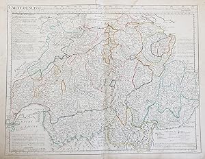
Carte de Suisse, ou sont les Cantons de Z�rich, Berne, Lucerne, Uri, Unterwald, Zug, Glaris, Basle, Fribourg, Soleurre, Schaffouse." - Schweiz Suisse Switzerland map Karte carte
Published by Paris, Dezauche ca. 1780., 1780
Seller: Antiquariat Steffen V�lkel GmbH, Seubersdorf, Germany
Seller Rating:

Map
Original altkolorierte Kupferstich-Karte von ca. 1780. -- Blattmasse: ca. 54 x 76 cm. -- im oberen und unteren Rand teils wasserfleckig, sonst gut erhalten. || Original hand colored engraved map from ca. 1780. with some waterstaining on the upper and lower margins, otherwise in good condition. || Dies ist ein Original! - Kein Nachdruck! - Keine Kopie! -- This is an original! - No copy! - No reprint! Sprache: Franz�sisch.
-
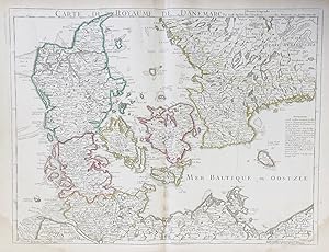
Carte du Royaume de Danemarc" - Danmark Denmark D�nemark
Published by Paris, Dezauche ca. 1780., 1780
Seller: Antiquariat Steffen V�lkel GmbH, Seubersdorf, Germany
Seller Rating:
Map
Original altkolorierte Kupferstich-Karte von ca. 1780. -- Blattmasse: ca. 54 x 76 cm. -- im unteren Rand teils wasserfleckig, sonst gut erhalten. || Original hand colored engraved map from ca. 1780. with some waterstaining on the lower margins, otherwise in good condition. || Dies ist ein Original! - Kein Nachdruck! - Keine Kopie! -- This is an original! - No copy! - No reprint! Sprache: Franz�sisch.
-
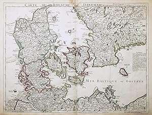
Carte du Royaume de Danemarc" - Danmark Denmark D�nemark
Published by Paris, Dezauche ca. 1780., 1780
Seller: Antiquariat Steffen V�lkel GmbH, Seubersdorf, Germany
Seller Rating:
Map
Original altkolorierte Kupferstich-Karte von ca. 1780. -- Blattmasse: ca. 54 x 72 cm. -- im oberen Rand teils leicht wasserfleckig, sonst gut erhalten. || Original hand colored engraved map from ca. 1780. with some waterstaining on the upper margin, otherwise in good condition. || Dies ist ein Original! - Kein Nachdruck! - Keine Kopie! -- This is an original! - No copy! - No reprint! Sprache: Franz�sisch.
-
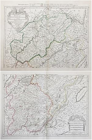
La Franche Comt� divis�e en Trois Grands Balliages scavoir d'Amont, d'Aval, et du Milieu ou de Dole subdivises en leurs Balliages." - Franche Comte Poligny Arbois Dole Besancon Pontarlier Salins-les-Bains Vesoul Lons-le-Saunier Champagnole carte gravure
Published by Paris, Dezauche ca. 1780., 1780
Seller: Antiquariat Steffen V�lkel GmbH, Seubersdorf, Germany
Seller Rating:
Map
Original altkolorierte Kupferstich-Karte von ca. 1780. Von 2 Platten gedruckt, zusammensetzbar. -- Blattmasse: jede Karte ca. 54 x 76 cm. -- gut erhalten. || Original hand colored engraved map from ca. 1780. Printed on two plates, can be joined together. in good condition. || Dies ist ein Original! - Kein Nachdruck! - Keine Kopie! -- This is an original! - No copy! - No reprint! Sprache: Franz�sisch.
-
![Seller image for Germania Antiqua in diversos populos qui eam coluerunt distincta. [ Carte de l'Allemagne sous l'Antiquit� ] for sale by Librairie du Cardinal](https://pictures.abebooks.com/inventory/md/md1256668650.jpg)
Germania Antiqua in diversos populos qui eam coluerunt distincta. [ Carte de l'Allemagne sous l'Antiquit� ]
Published by Delisle et Buache , D�zauche, 1796
Map
souple. Ex Itinerariis Locupletissimis que Antiquis Auctoribus, qui de hac Regione disseruerunt, et ex Mappis Geographicis Guillelmi Delisle Excerpta, 1 carte au format 83 x 58,5 cm, fronti�res rehauss�es en couleur, Delisle et Buache, D�zauche, Paris, 1796 Bon �tat Langue: Latin.
-
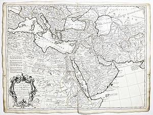
Carte de la Turquie de l'Arabie et de la Perse" - Turkey Saudi Arabia Iran Egypt Persia Arabien Persien T�rkei �gypten
Published by Paris, Dezauche, 1780
Seller: Antiquariat Steffen V�lkel GmbH, Seubersdorf, Germany
Seller Rating:
Map
Original altkolorierte Kupferstich-Karte von Guillaume Delisle von 1780. -- Blattformat: ca. 50 x 66 cm. -- mit kleinem hinterlegten Randeinriss, sonst gut erhalten. || Original old colored engraved map by Guillaume Delisle. with a small deposited marginal tear, otherwise in good condition. Sprache: Franz�sisch Gewicht in Gramm: 35.
-
Carte de l'Espagne. Dress�e par Guillaume Delisle sur la Description de Rodrigo Mendez Sylva et sur diverses Relations et Cartes Ms. Et Imprim�es. Rectifi�es par les Observations Astronomiques le tout augment� et v�rifi� en 1789 par Phil. Buache.
Seller: Librer�a Anticuaria Antonio Mateos, Malaga, Spain
Seller Rating:
Paris, Chez Dezauche, 1789, mapa original en plancha de 47 x 60 cm., con la cartela y los contornos coloreados de �poca.
-
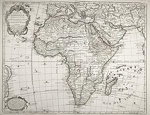
Carte d Afrique" - Africa Afrika continent Kontinent map Karte
Published by Paris, Dezauche, 1781
Seller: Antiquariat Steffen V�lkel GmbH, Seubersdorf, Germany
Seller Rating:
Map
original altkolorierte Kupferstich-Karte von 1781 - Blattformat: ca. 55 x 78 cm - im unteren Au�enrand etwas wasserfleckig, sonst gut erhalten. | original hand-colored copper engraved map from 1781. Rare edition! - with some waterstaining on the lower outer margin, otherwise in good condition.|| Dies ist ein Original! - Kein Nachdruck! - Keine Kopie! -- This is an original! - No copy! - No reprint! Sprache: Franz�sisch Gewicht in Gramm: 35.
-
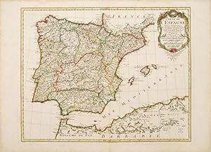
Carte l'Espagne Spain.
Published by Atlas Geographique des Quatre Parties du Monde. J.A.Dezauche. 1783, 1783
Seller: Peter Harrington. ABA/ ILAB., London, United Kingdom
Association Member: ABA ILAB PBFA
Seller Rating:
A splendid map of Spain, also shows the Balearic Islands and the coast of North Africa. Ornamented cartouche at top right. The colouring emphasizes the different provinces of Spain and Portugal Copper engraving. Original colour. The map itself is in very good condition, good margins, some sporadic foxing on margins, a few waterstains and slightly darkened to edges Size: 60 x 47 cm. (23� x 18� inches).
-
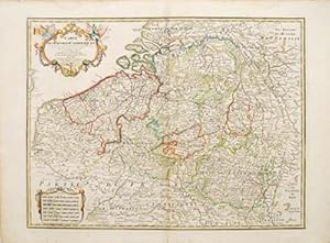
Carte des Paybas Catholiques
Published by Paris. 1780, 1780
Seller: Peter Harrington. ABA/ ILAB., London, United Kingdom
Association Member: ABA ILAB PBFA
Seller Rating:
Ornamental cartouche, seven different national scales, a good clear map showing the regions of Holland, Belgium and Luxembourg. The plates were originally made by De l'Isle around 1700. Covens and Mortimer reissued them in the Atlas Novissimo (1730-40). Phillipe Buache, de l'Isle's successor, and son in law continued to reissue de l'Isle's maps in the later eighteenth century Copper engraving. Original colour. The map itself is in fine condition, there are a couple of faint watermarks at top and left hand margins, there is a small tear at top right margin with a little loss, not affecting map Size: 62 x 47.5 cm.
-
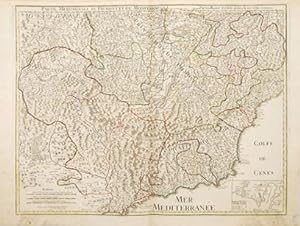
Condition: buona. Incisione in rame colorata a mano, raffigurante la costa mediterranea francese e italiana da Nizza a Monferrato. Sul margine superiore si trovano il titolo e tre scale. In basso a destra la mappa di Nizza. Esemplare in buono stato di conservazione con coloritura coeva e margini. Formato: 510x645mm.
-
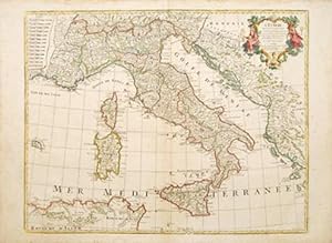
l'Italie.
Published by Paris. 1783, 1783
Seller: Peter Harrington. ABA/ ILAB., London, United Kingdom
Association Member: ABA ILAB PBFA
Seller Rating:
Ornamental cartouche at top right. 13 scales at top left. The map shows the whole of Italy, her islands and the Dalmatian coast. The map features a very decorative title cartouche. 'Atlas Geographique des Quatre Parties du Monde'. Size: 630 x 495 mm. Copper engraving. Original colour. Very good condition, sporadic foxing on margins, not affecting map. Darkened edges.
-

Condition: ottima. Incisione di rame acquerellata sui confini, raffigurante l'intera Italia, le sue isole e la costa della Dalmazia. In alto a destra la carta � arricchita dal cartiglio riportante il titolo, ed in alto a sinistra tredici scale. Esemplare in ottimo stato di conservazione con ampi margini. Engraved map with watercolor outlines. Very good condition. Ornamental cartouche at top right. 13 scales at top left. The map shows the whole of Italy, her islands and the Dalmatian coast. The map features a very decorative title cartouche. 'Atlas Geographique des Quatre Parties du Monde'. Formato: 555x774mm.
-
Carte de la Souverainete de Neuchatel et Vallangin
Publication Date: 1745
Seller: Argosy Book Store, ABAA, ILAB, New York, NY, U.S.A.
Seller Rating:
Map. Engraving with hand coloring. Image measures 19 x 25.5". This beautiful map depicts the Neuchatel region of Switzerland, showing the town of Neuchatel as well as Lake Neuchatel. It is based on a 1710 original by David Francois de Merveilleux redone by Guillaume de L'Isle and published by Philippe Buache. The map is is finely detailed with abbeys and priories, castles, battlefields, mineral springs, and forests. An elegant compass rose is shown in Lake Neuchatel, and a decorative title cartouche at the top of the map is flanked on either side by historical and geographical text in French. The map dates to the reign of Frederick I of Prussia, who presided over Neuchatel's golden age and ushered in a period of expansion in commerce, banking, and industry such as watchmaking and lace. The map is in excellent condition with wide margins as issued and no chips or tears. Minor stains in margins not affecting the image. Philippe Buache (1700--1773) was a French geographer who trained under the geographer Guillaume De L'Isle (1675--1726), a French cartographer known for his popular and accurate maps of Europe and the newly explored Americas and Africa. He is important as the first "scientific" cartographer who incorporated the most current information on exploration and topography into his maps.
-
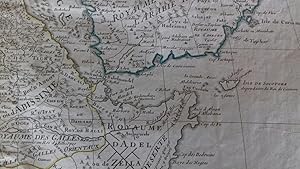
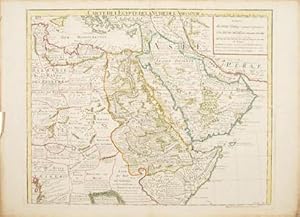
Carte de l'Egypte, de la Nubie, de l'Abissinie &c par Guillaume De lisle de l'Academie R. des Sciences (antique map of Egypt, Nubia, Abyssinia, etc.)
Published by Dezauche, Paris, 1780
First Edition
A stunning map of Arabia and northeastern Africa (from Libya and Egypt in the north to Somalia and the Gulf of Guinea in the south). 50 x 62 cm (plate), 55 x 76 cm (sheet). Arabia, Egypt, Sudan, and Abyssinia (Ethiopia) are wonderfully detailed; the interior much less so, with some marvelously cryptic comments ("Desert de Berdoa, d'une grande s�cheresse, o� il n'y a pas de s�ret� pour les marchands � cause de voleurs"; "Royaume de T�mian, dont les habitans sont � ce qu'on dit Antropophages.") Printed on fine, thick watermarked laid paper. Original outline color. Reverse blank. A fine impression. Three small faint stains in the upper margin that could easily be removed, and that in any case would be invisible were the map matted and framed), else A PRISTINE EXAMPLE, with the paper FINE AND BRIGHT. Very scarce in such fine condition.
-
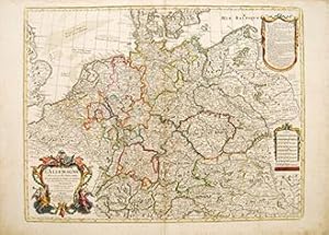
L'ALLEMAGNE, dresse sur les Observations de Tycho Brahe, de Kepler, de Snellius.
Published by Paris. 1788, 1788
Seller: Peter Harrington. ABA/ ILAB., London, United Kingdom
Association Member: ABA ILAB PBFA
Seller Rating:
Attractive ornamental cartouche, Two secondary cartouches, one containing nine scales, the other is an ' Avertissement' explaining the depiction of the German provinces and enclaves. The map not only shows Germany, but also the Low Countries, Switzerland, Austria parts of Poland and Hungary. The plates were originally made by De l'Isle around 1700. Covens and Mortimer reissued them. Phillipe Buache was de l'Isle's successor, and son in law, he continued to reissue de l'Isle's maps in the later eighteenth century. Copperplate engraving with later hand colour. Very good condition, some watermarks on margins, short closed tear at lower centrefold.some sporadic spotting and light browning on margins. Size: 64 x 49 cm.
-
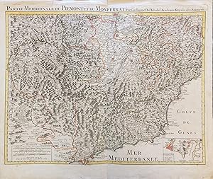
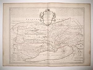
Partie Meridionale du Piemont et du Montferrat
Published by c 1730, 1730
Seller: Peter Harrington. ABA/ ILAB., London, United Kingdom
Association Member: ABA ILAB PBFA
Seller Rating:
This detailed and beautifully engraved map of the French/Italian Mediterranean coast from Nice to Montferrat, has no cartouche- the title is written in the top border, 3 scales, inset map at lower right of Nice.The plates were originally made by De l'Isle around 1700. Covens and Mortimer reissued them in the Atlas Novissimo (1730-40). Phillipe Buache, de l'Isle's successor, and son in law continued to reissue de l'Isle's maps in the later eighteenth century. Copper engraving. Hand coloured. Fine condition, good margins, edges a little browned Size: 64 x 49 cm.
-

Carte des Courones de Nord. comprenant le Suede, le Danemarc &c
Published by Dezauche, Paris. 1788 French., 1788
Seller: Peter Harrington. ABA/ ILAB., London, United Kingdom
Association Member: ABA ILAB PBFA
Seller Rating:
Fine elaborate cartouche, although the title suggests a map of Denmark, this handsome map shows the northern halves of Sweden, Norway and Finland. The plates were originally made by De l'Isle around 1700. Covens and Mortimer reissued them in the Atlas Novissimo (1730-40). Phillipe Buache, de l'Isle's successor, and son in law continued to reissue de l'Isle's maps in the later eighteenth century Copper engraving. Original colour. Fine condition, good margins, a little browned Size: 62 x 45 cm. (24� x 17� inches).
-
Carte del'Egypte de la Nubie de l'Abyssinie.
Published by Paris. c1780, 1780
Seller: Peter Harrington. ABA/ ILAB., London, United Kingdom
Association Member: ABA ILAB PBFA
Seller Rating:
An interesting map of north east Africa, with plenty of information, mostly very speculative about the interior of Africa- its people, regions and kingdoms.The plates were originally made by De l'Isle around 1700. Covens and Mortimer reissued them in the Atlas Novissimo (1730-40). Phillipe Buache, de L'Isle's successor, and son in law continued to re-issue de L'Isle's maps in the later eighteenth century Copper engraving. Original colour. Excellent condition, a little browned at edges Size: 61 x 49 cm. (24 x 19� inches).
-

Carte de Suisse
Published by Paris. c1750, 1750
Seller: Peter Harrington. ABA/ ILAB., London, United Kingdom
Association Member: ABA ILAB PBFA
Seller Rating:
A large, clear and detailed map of Switzerland, outlining the cantons, with their coats of arms at upper border alongside title. 'Avertissement' at at top left with description of the area. Atlas Geographique des Quatre Parties du Monde. Copper engraving. Original colour. Very good condition, a few waterstains at the slightly darkened edges, not affecting map, 2cm closed tear at lower centrefold Size: 64 x 49 cm.
-
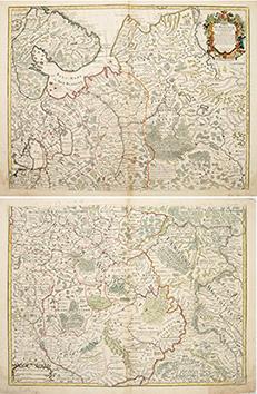
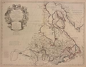
Carte de Moscovie
Published by Atlas de Geographie. Guillaume Delisle, Quai de Horloge. 1706, 1706
Seller: Peter Harrington. ABA/ ILAB., London, United Kingdom
Association Member: ABA ILAB PBFA
Seller Rating:
The map is in two parts, north and south, they are both of equal size. The northern map has a decorated cartouche, and shows the north of white Russia, and part of the arctic coast, reaches as far south as the Principality of Galicz. The southern map stretches to the northern tip of the Black Sea, the Volga in the East and a tiny bit of the Baltic Coast in the North West. There are some text on the map about the inhabitants, rivers etc, A very handsome pair of maps. The plates were originally made by Delisle around 1700. Covens and Mortimer reissued them in the Atlas Novissimo (1730-40). Phillipe Buache, de l'Isle's successor, and son in law continued to reissue Delisle's maps in the later eighteenth century. The price is for the pair. Copper engraving. Original colour. Very good condition, slightly browned margins, some sporadic spotting. Some nicks lower margins. Size: 66 x 50 cm. (26 x 19� inches).
-
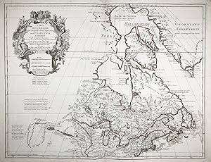
Carte du Canada qui comprend la Partie Septentrionale des Etats Unis d'Amerique" - United States Canada America Amerika Amerique USA Kanada
Published by Paris, Dezauche, 1783
Seller: Antiquariat Steffen V�lkel GmbH, Seubersdorf, Germany
Seller Rating:
Map
Altkolorierte Kupferstich-Karte von 1783. -- Blattformat: ca. 55 x 78 cm. -- im Au�enrand leicht fleckig, sonst gut erhalten. || Original hand-colored engraved map from 1783. Rare edition! Map originally published by G. Delisle in 1703. A very accurate map, precise in its depiction of the Great Lakes and the region of the rivers Hudson and Mississippi. This map is the first to include Etats-Unis" in its title, following the American Revolution, which also marks one of the first apperances of the term United States" on a map. Beautifully decorated cartouche includes images of animals (beaver, fish, duck) and Jesuit explorers. Native American tribes are also named on this map. - slightly stained on the outer margin, otherwise in good condition.|| Dies ist ein Original! - Kein Nachdruck! - Keine Kopie! -- This is an original! - No copy! - No reprint! Sprache: Franz�sisch Gewicht in Gramm: 35.
-
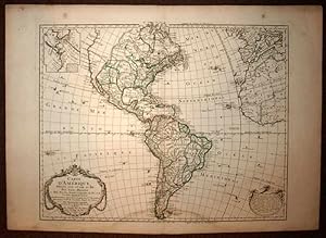
Pas de couverture. Condition: Tr�s bon. Edition originale. CARTE D'AMERIQUE A L'USAGE DU ROI Par GUILLAUME DELISLE et PHILIPPE BUACHE A Paris 1790 Gravure sur cuivre Papier pur chiffon 80 x 60 centimetres (format hors tout) Bon �tat, quelques rousseurs (voir les photos) GRAVURE ORIGINALE DE 1790.
-
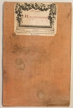
Mappemonde � l' usage du Roi. Par Guillaume Delisle et Philippe Buache. Premiers G�ographs de sa Majest� et de l' Acad�mie Sciences. Revue et Augment�e des N. D�couvertes par Dezauche en 1784.
Published by Paris, Dezauche, 1784
51,8 x 70 cm, tous les segments entoil�s, la carte �tant pli�e, Front., partiellement col., Kupferstich.
-
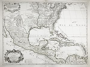
Carte du Mexique et des Etats-Unis d'Amerique. Partie Meridionale." - United States Mexico Caribbean USA America Amerika Amerique
Published by Paris, Dezauche, 1783
Seller: Antiquariat Steffen V�lkel GmbH, Seubersdorf, Germany
Seller Rating:
Map
Altkolorierte Kupferstich-Karte von 1783. -- Blattformat: ca. 55 x 78 cm. -- gut erhalten. || Original hand-colored engraved map from 1783. One of the most influential maps in the history of American cartography. This is one of the earliest editions of the map to reference the nearly formed title "Etats Unis" (United States) in the title. -- in good condition.|| Dies ist ein Original! - Kein Nachdruck! - Keine Kopie! -- This is an original! - No copy! - No reprint! Sprache: Franz�sisch Gewicht in Gramm: 35.
-
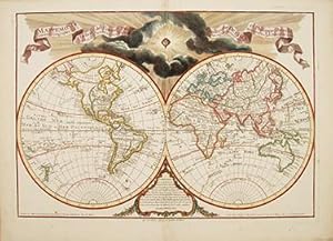
Mappe monde a l'usage de l'instruction.
Published by Paris: 1808, 1808
Seller: Peter Harrington. ABA/ ILAB., London, United Kingdom
Association Member: ABA ILAB PBFA
Seller Rating:
When Guillaume De Lisle died in 1726, Philippe Buache succeeded him and revised many of his maps. Buache died in 1773, and was succeeded by Dezauche who, in 1808, revised and augmented this beautiful world map. It shows the latest discoveries - Australia and New Zealand are complete, Japan is more or less accurately depicted, and the routes of Captain Cook are shown. Title on ribbon extending across top of print, with face of the sun dramatically shining through dark clouds at upper centre. Size: 660 x 435 mm. Copper engraving. Later colour. Fine condition.
-
Carte Du Canada Qui Comprend la Partie Septentrionale Des Etats Unis D'Amerique
Published by Dezauche, 1783
Seller: Argosy Book Store, ABAA, ILAB, New York, NY, U.S.A.
Seller Rating:
Map. Engraving with hand coloring. Image measures 19.75 x 25.5". Sheet measures 21.5 x 30". This map of Canada and the northern United States extends north from around the latitude of Baltimore all the way up to Baffin Bay along the shore of Greenland. Published by Jean-Claude Dezuache in 1783, it is the eighth revision of a map originally published by De L'Isle in 1703. The map is notable as the first to include "Etats-Unis" in the title, coming as it did on the heels of the American Revolution. In fact, this appearance is one of the earliest appearances of the name United States (Etats-Unis) on a printed map. The map is compelling in its accuracy, particularly with regard to the Great Lakes, depicting them as fully enclosed and properly placed in longitude and latitude. There is also excellent detail around the Hudson and Mississippi Rivers. The elaborate cartouche is decorated with a beaver, natives (one of whom is bearing a scalp), and Jesuit explorers. Furthermore, the fleurs-de-lis that previously adorned the shield at the top of the cartouche has been erased and the crown converted into a halo suspended above an orb, a response to the execution of the king following the French Revolution Below, a table of colors delineates the boundaries of the United States and European possessions. Indian nations are also labeled. The map is in excellent condition with wide margins as issued. Guillaume De L'Isle (1675--1726) was a French cartographer known for his popular and accurate maps of Europe and the newly explored Americas and Africa. He is important as the first "scientific" cartographer who incorporated the most current information on exploration and topography into his maps. Philippe Buache (1700--1773) was a student of De L'Isle and became one of the most active proponents of the so-called school of theoretical cartography active in mid-18th century France. This map is fascinating record from a remarkable moment in North American history.
-

Condition: Fine. Size: 55.5cm x 73.5cm Number of books: 1.