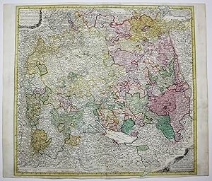
Homann Erben (165 results)
Published by Nuremberg 1789
- Map
Seller: Robert Frew Ltd. ABA ILAB, London, , United KingdomRobert Frew Ltd. ABA ILAB
Contact seller5-star sellerCondition: Used
US$ 68.15
US$ 13.23 shippingShips from United Kingdom to U.S.A.Quantity: 1 available
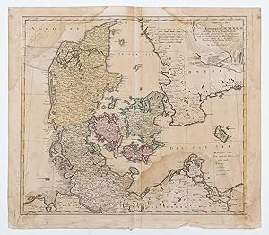
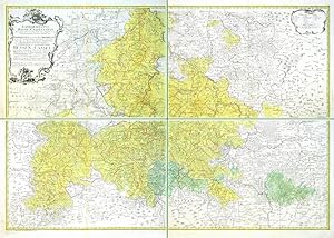
48 x 55 cm. Double page engraved map with original colour Some dampstaining.

Language: German
Published by Homann Erb, Nürnberg 1745
- Art Print
Seller: avelibro OHG, Dinkelscherben, , Germanyavelibro OHG
Contact seller5-star sellerCondition: Used - Very good
US$ 65.01
US$ 11.48 shippingShips from Germany to U.S.A.Quantity: 1 available
49,5 x 37 cm. 53,5 x 41 cm. Condition: Gut. Kol.Kupf. Homann Homan Erben. Tabelle der größten Städte im Altertum nud der Neuzeit. Verfertigit von Joh.Matth.Hassius, Mattem. Prof. Tadellos erhalten. deu S 1|45BG Sprache: Deutsch Gewicht in Gramm: 444.
Published by Nürnberg 1746
- Softcover
Seller: Antikvariat Krenek, Prag, , Czech RepublicAntikvariat Krenek
Contact seller5-star sellerCondition: Used
US$ 221.65
US$ 16.64 shippingShips from Czech Republic to U.S.A.Quantity: 1 available
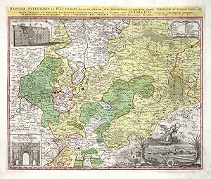
Hessen. "Hassiae Superioris et Wetterau. partis delineatio". Altkol. Kupf.-Kte. nach C. M. Pronner bei Homann Erben, dat. 1746. Mit Kopftitel, gr. fig. u. herald. Kart. mit Ansicht von Giesen (ca. 5:14 cm), ornament. Kart. u. 2 Ansichten der Giessene Universität bzw. der Ehenpforte der Universität. 48:56 cm. Karte von Oberhessen… mit der Wetterau.
Published by Nürnberg 1749
- Softcover
Seller: Antikvariat Krenek, Prag, , Czech RepublicAntikvariat Krenek
Contact seller5-star sellerCondition: Used
US$ 320.15
US$ 16.64 shippingShips from Czech Republic to U.S.A.Quantity: 1 available
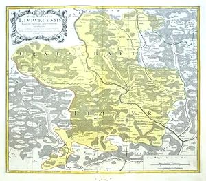
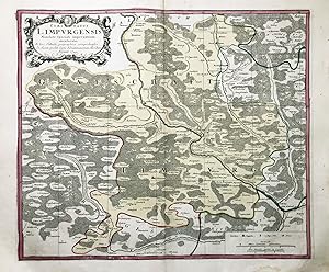
"Comitatus Limpurgensis". Orig. altkol. Kupferkarte bei Homann Erben, Nürnberg, 1749. Mit ornament. Titelkart, mit Wappen und Kart. mit Meillenanzeiger und Erklärungen. 45,5:53,5 cm. Detaillierte Karte von der Grafschaft Limpurg und angrenzende Gebiete. Die Grafschaft lag im heutigen Landkreis Schwäbisch-Hall bzw. Ostalbkreis zw…ischen Schwäbisch-Hall, Schwäbisch Gmünd, Aalen und Ellwangen.
Published by Nürnberg 1743
- Softcover
Seller: Antikvariat Krenek, Prag, , Czech RepublicAntikvariat Krenek
Contact seller5-star sellerCondition: Used
US$ 369.40
US$ 16.64 shippingShips from Czech Republic to U.S.A.Quantity: 1 available
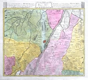
Munich. "Carte des Environs de Munich la Capitale de Baviere - Karte von der Gegend um Munchen, der Haupt Stadt im Herzogth: Bayern". Altkol. Kupf.-Kte. bei Homann Erben, dat. 1743. Mit fr.-dt. Kopftitel u. ornament. Kart. mit Erklärungen. 50:53 cm. Karte von München und Umgebung.
Published by Nürnberg 1761
- Softcover
Seller: Antikvariat Krenek, Prag, , Czech RepublicAntikvariat Krenek
Contact seller5-star sellerCondition: Used
US$ 492.52
US$ 16.64 shippingShips from Czech Republic to U.S.A.Quantity: 1 available
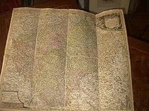
"Landgrafiatus Hasso-Cassellanus . Niederhessen, wie auch ein Theil Oberhessen . Fürstentum und Landgrafschaft Hessen-Cassel". Alkol. Kupf-Kte. bei Homann Erben, Nürnberg, 1761. Mit gr. ornament. Titelkart. mit Wappen und 2 Putten und andere ornament. Kart. mit Erklärungen ("Erklaerung der Zeichen"). 78:114 cm. A large map of th…e Landgraviate of Hesse. Printed from 4 plates, not joined. - Each leaf with full margins (4-8 cm).

Published by Artist: Homann Erben ( - 1780 ) Nuremberg dated : 1786 1724
- Hardcover
Seller: Antique Sommer& Sapunaru KG, München, , GermanyAntique Sommer& Sapunaru KG
Contact seller4-star sellerCondition: Used
US$ 2,245.73
US$ 51.64 shippingShips from Germany to U.S.A.Quantity: 1 available
Technic: Copper print, colorit: original colored, condition: 16 sheets, joined together, size (in cm): 75 x 93 cm, Large map showing the postal routes of all Germany from the time of the Roman Empire Prince of Thurn and Taxis, Counts of Valsassina, Freyherrn Impden, Eglingen and Osterhofen etc.of the Sovereign Province of Hainau…lt Hereditary Marshal Knights of the Golden Fleece. With the Netherlands, Poland, Czech Republic, Austria, Switzerland, Hungary, Romania, northern Italy, partly France with Paris and four magnificent cartouches. Until the late Middle Ages, there was no public postal service in Germany.Maximilian I introduced a new system of messaging in the Holy Roman Empire in 1490 with postal stations, where horsemen exchanged horses and/or messages. Because of the postal contract between Philip the Fair and Francis of Taxis in 1505, the latter has long been credited with founding the first modern postal enterprise. However, this post was initially a dynastic post, not open to the general public. In the second half of the 16th century, other German princes also established their own message boards. At first, these served only the princely post office and not the public. During the Thirty Years' War (1618-1648), the post was of extraordinary importance. The Peace of Westphalia (1648) gave the sovereigns full sovereignty over their territories. No decision was made about the postal sovereignty. In 1658, with the election of Emperor Leopold I. (1640-1705), the rights of the Taxis family, who had called themselves Thurn und Taxis since 1650, to the post of postmaster general in the Holy Roman Empire were confirmed. An additional protocol stipulated that the postal regal of the sovereigns should not be affected by this. Eugen Alexander von Thurn und Taxis was elevated to hereditary princely status as Imperial Postmaster General in the Holy Roman Empire in 1695. Since 1819, the Thurn and Taxis postal territory had comprised: Württemberg, both Hesse and Nassau, the Thuringian states, the Lippe principalities, the Oldenburg principality of Birkenfeld, Hohenzollern and the Free City of Frankfurt am Main. It was not until 1850, with the merger of the German-Austrian Postal Association as an amalgamation of small-state posts, that a uniform rate system came into effect.
 More images
Published by Sumtibus Homannianis Heredibus Norimbergae, 1769, 1769
- Hardcover
Seller: Harteveld Rare Books Ltd., Marly, SwitzerlandHarteveld Rare Books Ltd.
Contact seller4-star sellerCondition: Used
US$ 9,540.09
US$ 22.95 shippingShips from Switzerland to U.S.A.Quantity: 1 available
gr. in-Folio, (ca. 60:36 cm), Gest. Titel mit lateinisch-deutschem Index u. 20 altkolorierten Kupferkarten + 1 zusätzl. doppelblattgr. Karte v. Neuchâtel (1778) - Teilw. gebräunt, Ränder stellenweise etwas angestaubt u. fingerfleckig. Kupfertitel mit Randeinriss. Sammlung loser Tafeln / collection des cartes complète de l?atlas,… non relié. Spezialatlas der Schweiz, auch als "Walser-Atlas" bekannt: 12 der 13 Kantonskarten der Alten Orte sowie die Karten von St. Gallen, Graubünden u. Wallis entstanden 1763-1768 nach Entwürfen von Gabriel Walser. Von Rizzi Zannoni sind die Karten des Bodensees (Turgoviae. 1766) und Genfer Sees (avec Duché de Chablais et Savoye), Gesamtkarte der Schweiz u. Schaffhausen von T. Majer, enth. schließlich noch die Gesamtkarte von J. B. Homann (mit Kolorit nach Religionen). Ferner zusätzlich die erst 1778 entstandene Karte des (damals preußischen) Neufchâtel (1778). // Les cartes - die Karten : 1) Carte générale de la Suisse, 1751 / 2) Carte des religions en Suisse 1732 / 3) Zürich 1765 / 4) Berne 1766, / 5) Lucerne 1763 / 6) Uri 1768 / 7) Schwyz 1767 / 8) Unterwald 1767 / 9) Zug 1768 / 10) Glaris 1768 / 11) Basel 1767 / 12) Fribourg 1767 / 13) Soleure 1766 / 14) Schaffhouse 1753 / 15) Appenzell 1768, 16) St-Gall 1768 / 17) Grisons 1768 / 18) Valais 1768 / 19) Lac Léman & Genève 1766 / 20) Lac de Constance & Turgovie 1766 / 21) Neuchâtel & Valangin 1778 (en supplément).Please notify before visiting to see a book. Prices are excl. VAT/TVA (only Switzerland) & postage. Phillips 3151 u 4066; Blumer 255/6.

- Hardcover
- Print on Demand
Seller: True World of Books, Delhi, , IndiaTrue World of Books
Contact seller5-star sellerLeatherBound. Condition: New. BOOKS ARE EXEMPT FROM IMPORT DUTIES AND TARIFFS; NO EXTRA CHARGES APPLY. Leather Binding on Spine and Corners with Golden leaf printing on spine. Bound in genuine leather with Satin ribbon page markers and Spine with raised gilt bands. A perfect gift for your loved ones. Reprinted from 1769 edition.… NO changes have been made to the original text. This is NOT a retyped or an ocr'd reprint. Illustrations, Index, if any, are included in black and white. Each page is checked manually before printing. As this print on demand book is reprinted from a very old book, there could be some missing or flawed pages, but we always try to make the book as complete as possible. Fold-outs, if any, are not part of the book. If the original book was published in multiple volumes then this reprint is of only one volume, not the whole set and contains approximately 18 pages. IF YOU WISH TO ORDER PARTICULAR VOLUME OR ALL THE VOLUMES YOU CAN CONTACT US. Resized as per current standards. Sewing binding for longer life, where the book block is actually sewn (smythe sewn/section sewn) with thread before binding which results in a more durable type of binding. Language: Latin.

Language: Latin
Published by Nürnberg um 1740. 1740
- Map
Seller: Antiquariat Steffen Völkel GmbH, Seubersdorf, GermanyAntiquariat Steffen Völkel GmbH
Contact seller5-star sellerCondition: Used
US$ 59.09
US$ 34.43 shippingShips from Germany to U.S.A.Quantity: 1 available
Original altkolorierte Kupferstich-Karte von ca. 1740. Zeigt den Rheinlauf von Bonn bis Worms. -- Blatt-Maße: ca. 56 x 61 cm. -- im unteren Mittelbug hinterlegt, mit alter Knickspur, sonst gut erhalten. || Original old colored copper engraved map from around 1740. -- deposited on the lower centerfod, with old crease, otherwise i…n good condition. || Dies ist ein Original! - Kein Nachdruck! - Keine Kopie! -- This is an original! - No copy! - No reprint! // Wir, das Antiquariat Steffen Völkel, kaufen und verkaufen alte Bücher, Handschriften, Zeichnungen, Autographen, Grafiken und Fotografien. Wir sind stets am Ankauf von kompletten Bibliotheken, Sammlungen und Nachlässen interessiert. la Gewicht in Gramm: 1550.
Language: Latin
Published by Nürnberg 1749
- Map
Seller: Antiquariat Steffen Völkel GmbH, Seubersdorf, GermanyAntiquariat Steffen Völkel GmbH
Contact seller5-star sellerCondition: Used
US$ 59.09
US$ 34.43 shippingShips from Germany to U.S.A.Quantity: 1 available
Original altkolorierte Kupferstich-Karte von 1749. -- Blatt-Maße: ca. 54 x 62 cm. -- im Außenrand teils etwas fleckig, sonst gut erhalten. || Original old colored copper engraved map from 1749. -- partly somewhat stained on the outer margin, otherwise in good condition. // Wir, das Antiquariat Steffen Völkel, kaufen und verkaufe…n alte Bücher, Handschriften, Zeichnungen, Autographen, Grafiken und Fotografien. Wir sind stets am Ankauf von kompletten Bibliotheken, Sammlungen und Nachlässen interessiert. la Gewicht in Gramm: 30.
Language: Latin
Published by Nürnberg, Homann Erben 1743
- Map
Seller: Antiquariat Steffen Völkel GmbH, Seubersdorf, GermanyAntiquariat Steffen Völkel GmbH
Contact seller5-star sellerCondition: Used
US$ 59.09
US$ 34.43 shippingShips from Germany to U.S.A.Quantity: 1 available
Original altkolorierte Kupferstich-Karte von Johann Baptist Homann (1664-1724) von 1743. -- Blatt-Maße: ca. 54 x 62 cm. -- im Randbereich teils etwas fleckig, sonst gut erhalten. || Original old colored engraved map by Johann Baptist Homann (1664-1724) from 1743. // Wir, das Antiquariat Steffen Völkel, kaufen und verkaufen alte…Bücher, Handschriften, Zeichnungen, Autographen, Grafiken und Fotografien. Wir sind stets am Ankauf von kompletten Bibliotheken, Sammlungen und Nachlässen interessiert. la Gewicht in Gramm: 35.

Language: French
Published by Venezia, Santini & Remondini 1776
- Map
Seller: Antiquariat Steffen Völkel GmbH, Seubersdorf, GermanyAntiquariat Steffen Völkel GmbH
Contact seller5-star sellerCondition: Used
US$ 212.75
US$ 34.43 shippingShips from Germany to U.S.A.Quantity: 1 available
Großformatige altkolorierte Kupferstich-Karte von 1776.-- Blatt-Maße: ca. 52,5 x 75,5 cm. -- gut erhalten. || Large old colored engraved map from 1776. -- in good condition. || Francesco Santini was a Venetian publisher. He acquired the printing plates of Vaugondy's Atlas Universel, a commercial and cartographic success, with wi…despread influence on mapmakers throughout Europe. Together with his brother Paolo, he commissioned a new set of plates and reissued the atlas in 1776. In the following years, Paolo Santini assigned all his publication rights to M. Remondini, who in 1777 reissued the same atlas, but with his name. // Wir, das Antiquariat Steffen Völkel, kaufen und verkaufen alte Bücher, Handschriften, Zeichnungen, Autographen, Grafiken und Fotografien. Wir sind stets am Ankauf von kompletten Bibliotheken, Sammlungen und Nachlässen interessiert. Sprache: Französisch Gewicht in Gramm: 550.
Published by Nürnberg: Homännische Officin dat. , 1745
Seller: Antiquariat Ruthild Jäger, Lueneburg, GermanyAntiquariat Ruthild Jäger
Contact seller3-star sellerCondition: Used
US$ 94.56
US$ 34.43 shippingShips from Germany to U.S.A.Quantity: 1 available
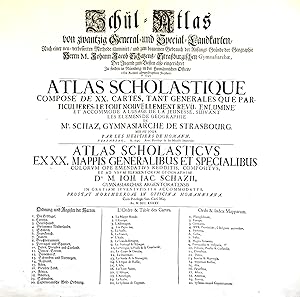
(Gr.-Folio). 1 Blatt (mittig gefaltet), 56 x 51 cm. (minimale Randeinrisse sorgfältig unterlegt, sonst sehr gut erhalten; small tears in the margins repaired, otherwise in good condition). * Auf dem deutsch/französisch/lateinischen Titelblatt werden die zwanzig im Atlas enthaltenen Landkarten aufgeführt. Der Homann'sche Schul-At…las war konzipiert als Ergänzung des Geographie-Lehrbuches für Schulen aus der Feder des Gymnasialdirektors Johann Jacob Schatz (1720 Rektor in Trarbach, 1728 Direktor und Bibliothekar Gymnasium Eisenach, 1737 Direktor Gymnasium Straßburg). (#9677AB).

Published by Homann, Nürnberg 1762
- Map
Seller: Antiquariat Reinhold Berg eK Inh. R.Berg, Regensburg, , GermanyAntiquariat Reinhold Berg eK Inh. R.Berg
Contact seller5-star sellerCondition: Used
US$ 112.29
US$ 27.54 shippingShips from Germany to U.S.A.Quantity: 1 available
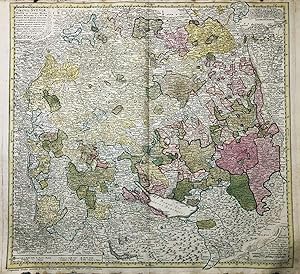
Original antike Kupferstichkarte in zeitgenöss. Grenz- u. Flächenkolorit. Links unten befindet sich die Kartusche mit Titel, Meilenzeiger u. Legende, dekorativ umrahmt von allegorischen Darstellungen, darüber ist das Wappen von Lyon eingraviert. Oben im Titel bezeichnet und datiert ? sous des Heritiers d'Homan 1762'. Guter Erhal…tungszustand. Einige Falten im Bereich des Mittelfalzes. 46 x 56 cm (18 x 22 inches).

Language: German
Published by Nürnberg 1752
- Map
Seller: Antiquariat Steffen Völkel GmbH, Seubersdorf, GermanyAntiquariat Steffen Völkel GmbH
Contact seller5-star sellerCondition: Used
US$ 70.91
US$ 34.43 shippingShips from Germany to U.S.A.Quantity: 1 available
Original altkolorierte Kupferstich-Karte von 1752. -- Blatt-Maße: ca. 54 x 62 cm. -- gut erhalten. || Original old colored engraved map from 1752. -- in good condition. // Wir, das Antiquariat Steffen Völkel, kaufen und verkaufen alte Bücher, Handschriften, Zeichnungen, Autographen, Grafiken und Fotografien. Wir sind stets am An…kauf von kompletten Bibliotheken, Sammlungen und Nachlässen interessiert. Sprache: Deutsch Gewicht in Gramm: 35.

Language: Latin
Published by Nürnberg, Homann Erben 1743
- Map
Seller: Antiquariat Steffen Völkel GmbH, Seubersdorf, GermanyAntiquariat Steffen Völkel GmbH
Contact seller5-star sellerCondition: Used
US$ 70.91
US$ 34.43 shippingShips from Germany to U.S.A.Quantity: 1 available
Original altkolorierte Kupferstich-Karte von Johann Baptist Homann (1664-1724) von 1743. -- Blatt-Maße: ca. 59 x 53,5 cm. -- Im unteren Mittelbug leicht hinterlegt, sonst gut erhalten. || Original old colored engraved map by Johann Baptist Homann (1664-1724) from 1743. -- Slightly backed in the lower center bow, otherwise in goo…d condition. // Wir, das Antiquariat Steffen Völkel, kaufen und verkaufen alte Bücher, Handschriften, Zeichnungen, Autographen, Grafiken und Fotografien. Wir sind stets am Ankauf von kompletten Bibliotheken, Sammlungen und Nachlässen interessiert. la Gewicht in Gramm: 1550.
Language: Latin
Published by Nürnberg, Homann Erben 1743
- Map
Seller: Antiquariat Steffen Völkel GmbH, Seubersdorf, GermanyAntiquariat Steffen Völkel GmbH
Contact seller5-star sellerCondition: Used
US$ 70.91
US$ 34.43 shippingShips from Germany to U.S.A.Quantity: 1 available
Original altkolorierte Kupferstich-Karte von Johann Baptist Homann (1664-1724) von 1743. -- Blatt-Maße: ca. 62 x 53 cm. -- mit kleineren hinterlegten Einrissen, sonst gut erhalten. || Original old colored engraved map by Johann Baptist Homann (1664-1724) from 1743. -- with minor deposited tears, otherwise in good condition. // W…ir, das Antiquariat Steffen Völkel, kaufen und verkaufen alte Bücher, Handschriften, Zeichnungen, Autographen, Grafiken und Fotografien. Wir sind stets am Ankauf von kompletten Bibliotheken, Sammlungen und Nachlässen interessiert. la Gewicht in Gramm: 1550.
 More images
Condition: Used - Very good
US$ 114.65
US$ 33.28 shippingShips from France to U.S.A.Quantity: 1 available
Pas de couverture. Condition: Assez bon. Um 1770; Grenz und Flächen kolorierte Kupferstich Karte, in 8 Segmenten auf Leinen aufgezogen, 57X50 cm, Titelkartusche in Latein; am oberen Rande in französischer Sprache; guter Zustand, leichte Benutzungspuren am Rande.
 More images
Published by Verlag: J. B. Homann
- Map
Seller: Magnus, Paris, , FranceMagnus
Contact seller4-star sellerCondition: Used - Very good
US$ 124.11
US$ 33.28 shippingShips from France to U.S.A.Quantity: 1 available
Pas de couverture. Condition: Assez bon. Um 1750.Kolorierte Kupferstichkarte, auf Leinen aufgezogen und in 8 Segmenten geteilt; 50 x 58 cm). am Rande leicht fleckig, leichte Benutzungspuren.

Published by Nürnberg 1757,
Seller: Antiquariat Cellensia, Celle, , GermanyAntiquariat Cellensia
Contact seller3-star sellerCondition: Used
US$ 88.65
US$ 68.85 shippingShips from Germany to U.S.A.Quantity: 1 available
Kupferstich. Altkoloriert. Blatt. 51 x 60 cm. Karte: 46,5 x 55 cm. Papier gleichmäßig gebräunt u. angestaubt. Oberer Rand Wasserfleck.
 More images
Published by Nuremberg: Homann Erben, 1753. 1753
Seller: William Matthews/The Haunted Bookshop, Sidney, BC, CanadaWilliam Matthews/The Haunted Bookshop
Contact seller5-star sellerCondition: Used
US$ 181.84
US$ 18.00 shippingShips from Canada to U.S.A.Quantity: 1 available
A copper engraved map on laid paper, uncoloured cartouche in upper left. Margins and parts of map are hand-coloured. Plate size is 56cm x 45cm, on a sheet measuring 62.5cm x 51cm. Verso blank. Text at top of plate: Le Canton ou Territoire de la Republique de Schafhouse en Suisse, Leve cy devant par Mr. Pejer, Capitaine, et publi…e par les Heritiers de Homann l'an 1753. The imprint within the cartouche is: Excuda Studio Homannianorum Heredum, 1753. Numeral in pen at upper right blank margin, "140". Modest edge wear, a clean and attractive copy. A regional map of Switzerland.
 More images
Published by Nuremberg: Homann Erben, 1748. 1748
Seller: William Matthews/The Haunted Bookshop, Sidney, BC, CanadaWilliam Matthews/The Haunted Bookshop
Contact seller5-star sellerCondition: Used
US$ 181.84
US$ 18.00 shippingShips from Canada to U.S.A.Quantity: 1 available
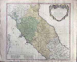
A copper engraved map on laid paper, large colour cartouche in upper right, including two coats-of-arms. Entire map is hand-coloured. Plate size is 57cm x 49cm, on a sheet measuring 63cm x 52cm. Verso blank. Text at top of plate: Les Etats de L'EGLISE & du Grand Duche de TOSCANE dresses par Mr. Tob. Mayer, de la Soc. Geogr. chez… les Herit de Homann. / L'An. MDCCXLVIII Avec Privilege Imperial. The imprint within the cartouche is: Homannianis Heredibus Norimbergae . 1748. Numeral in pen at upper right blank margin, small letter "V" within lower right corner of plate. A clean and attractive copy. A map of central Italy by Tobias Mayer, including Tuscany, and the cities Livorno, Bologna, Florenz, Ferrara, Ravenna, Urbino, Siena, Orvieto, Spoleto, and Rome.
Published by Nürnberg, Homann Erben. 1784
Seller: Daniel Thierstein, Bern, SwitzerlandDaniel Thierstein
Contact seller4-star sellerCondition: Used
US$ 172.30
US$ 40.16 shippingShips from Switzerland to U.S.A.Quantity: 1 available
Plattengrösse:48,5x59 cm. Blattgrösse: 58x68,5 cm. Grenz- und flächenkolorierte Kupferstichkarte. Mittelfalz. Sammlung Ryhiner 1103 6. - Mit einer Graden-Tafel und Meilen-Maas. - Fleckig und gebräunt. Ecken ausgefranst. Sprache: n.
Published by Nürnberg, Homann Erben. 1776
Seller: Daniel Thierstein, Bern, SwitzerlandDaniel Thierstein
Contact seller4-star sellerCondition: Used
US$ 172.30
US$ 40.16 shippingShips from Switzerland to U.S.A.Quantity: 1 available
Plattengrösse:49,5x56,5 cm. Blattgrösse: 59x69 cm. Grenz- und flächenkolorierte Kupferstichkarte. Mittelfalz. Sammlung Ryhiner 5501 42. - Titelkartusche oben links. Sprache: n.
 More images
Published by Nuremberg: Homann Erben, [c.1740]. 1740
Seller: William Matthews/The Haunted Bookshop, Sidney, BC, CanadaWilliam Matthews/The Haunted Bookshop
Contact seller5-star sellerCondition: Used
US$ 218.21
US$ 18.00 shippingShips from Canada to U.S.A.Quantity: 1 available
A copper engraved map on laid paper, cartouche in upper left. Entire map is hand-coloured. Plate size is 50cm x 47cm, on a sheet measuring 62cm x 51.5cm. Verso blank. Text at top of plate: Tavola Dello STATO Di MODENA, accuratamente diviso ne suoi Ristretti, cioe nel Ducato di Modena Reggio, Mirandola, nel Principato di Carpi e…Correggio, come pure de Paesi vicini. A studio, e Spese degli Eredi Homann Norimberga. The imprint within the cartouche is: studio et Sumptibus Homanianorum Heredum Noribergae. Numeral in pen at upper right blank margin, "112". A clean and attractive copy. A regional map of Italy, the Dukedom of Modena.

Published by Homann, J. B., Nürnberg 1762
- Map
Seller: Antiquariat Reinhold Berg eK Inh. R.Berg, Regensburg, , GermanyAntiquariat Reinhold Berg eK Inh. R.Berg
Contact seller5-star sellerCondition: Used
US$ 212.75
US$ 27.54 shippingShips from Germany to U.S.A.Quantity: 1 available
Original antique copper engraving, hand colored in outline and wash when published. Johann Baptist Homann(20 March 1664 1 July 1724) was a Germangeographerandcartographer, who also made maps of theAmericas.Homann was born in Oberkammlach nearKammlachin theElectorate of Bavaria. Although educated at aJesuitschool, and preparing f…or an ecclesiastical career, he eventually converted toProtestantismand from 1687 worked as acivil law notaryinNuremberg. He soon turned toengravingand cartography; in 1702 he founded his own publishing house.Homann acquired renown as a leading German cartographer, and in 1715 was appointed Imperial Geographer by EmperorCharles VI. Giving such privileges to individuals was an added right that theHoly Roman Emperorenjoyed. In the same year he was also named a member of thePrussian Academy of SciencesinBerlin. Of particular significance to cartography were the imperialprinting privileges(Latin:privilegia impressoria). These protected for a time the authors in all scientific fields such as printers,copperengravers, map makers and publishers. They were also very important as a recommendation for potential customers.In 1716 Homann published his masterpieceGrosser Atlas ueber die ganze Welt(Grand Atlas of all the World). Numerous maps were drawn up in cooperation with the engraverChristoph Weigel the Elder, who also publishedSiebmachers Wappenbuch.Homann died in Nuremberg in 1724. He was succeeded by his son Johann Christoph (1703-1730). The company carried on upon his death asHomann heirscompany, managed by Johann Michael Franz and Johann Georg Ebersberger. After subsequent changes in management the company folded in 1852.[1]The company was known as "Homann Erben", "Homanniani Heredes", or "Heritiers de Homann" abroad. (Wikipedia) In very good condition. 40 x 55 cm (15.75 x 21,75 inches).

Published by Artist: Homann Erben ( - 1780 ) Nuremberg ca : 1786 1724
Seller: Antique Sommer& Sapunaru KG, München, , GermanyAntique Sommer& Sapunaru KG
Contact seller4-star sellerCondition: Used
US$ 189.11
US$ 51.64 shippingShips from Germany to U.S.A.Quantity: 1 available
Technic: Copper print, colorit: colored, condition: Perfect condition, size (in cm): 21 x 22,5 cm, Detailed oversigt map of a German post way map of 1780. This map is part of a big folded postway mapof Homann.
 More images
Published by Nürnberg, Homannianorum Heredum 1733
- Art Print
Seller: Inanna Rare Books Ltd., Skibbereen, CORK, IrelandInanna Rare Books Ltd.
Contact seller5-star sellerCondition: Used - As new
US$ 212.75
US$ 32.13 shippingShips from Ireland to U.S.A.Quantity: 1 available
Condition: Wie neu. Original hand-coloured copper-engraving. Plate Size: 49.1 cm x 57.8 cm. Sheet Size: 54.5 cm x 77 cm. Original map. In good- condition. Some browning and damp-staining evident to outer margins. Some minor imperfections to outer margins also. Sign of damge to map detail near center fold at right border. Discree…t duplicate library stamps in Polish and inked annotation on reverse. Interesting and detailed map of The Netherlands from Zierikzee in the south to Den Helden in the north. The map is crowded with topographical detail, showing the location of rivers, hills, cities -such as Amsterdam and Rotterdam - towns and the network of roads canals criss-crossing Holland. The political sub-division of Holland are also shown. The precariousness of Dutch security is evident through the myriad of fortified towns and cities across the map. The sandbanks of the shallow Zuiderzee (De Zuyder Zee) can be seen. Haarlemmer Meer and Leydsche Meer are also identified on the map - much of this was drained and reclaimed in the 19th and 20th centuries. Large decorative title cartouche illustrating the Dutch maritime, trading and agricultural richness and traditions lies off the coast in the North Sea ('Mare Germanicum vulgo De Noord Zee'). Bar scales and map reference keys can be seen beneath cartouche. Homann Erben/Heirs was a prominent German publishing firm in the European map market throughout the eighteenth century. Founded in 1702 by Johann Baptist Homann, the business passed to his son, Christoph, upon Johann's death in 1724. Christoph died in 1730, aged only 27, and the firm was inherited by subsequent Homann heirs. This changed the name of the company, which was known as Homann Erben, or Homann heirs. The firm continued in business until 1848.

Published by Nürnberg 1780
- Map
Seller: Antiquariat Reinhold Berg eK Inh. R.Berg, Regensburg, , GermanyAntiquariat Reinhold Berg eK Inh. R.Berg
Contact seller5-star sellerCondition: Used
US$ 230.48
US$ 27.54 shippingShips from Germany to U.S.A.Quantity: 1 available
Other. Original antike Kupferstichkarte in zeitgenöss. Grenz- u. Flächenkolorit. Rechts oben Muschelkartusche mit Titel, Meilenzeiger u. Legende, dekorativ umrahmt von allegorischen Darstellungen (Wappen v. Putten gehalten, Neptun, etc.). Dargestellt wird der bayr. Kreis von Homann nach dem Teschener Frieden. Das Kartenbild ents…pricht, bis auf die politischen Grenzen, der Ausgabe von Homann,J. B. von 1728. Die Kupferplatte wurde neu gestochen und weist im un teren Rand auf die ab 1779 durch den Teschener Frieden zustandegekommenen politischen Veränderungen hin ( Das violet blau bedeckte Land haben Ihro Roem. Kaiserl. Maj. durch den Teschener Frieden erhalten. ). 2 kleinere althin terlegte Einrisse am äußeren Rand, sonst schönes kräftig gedrucktes Exemplar in sorgfältigem zeitgenöss. Kolorit. Leichte Gebrauchsspuren. 560 by 480mm (22 by 19 inches).


