Order Total (1 Item Items):
Shipping Destination:

Joseph Hutchins Colton 1800 1893 (25 results)
Skip to main search results
Product Type
- All Product Types
- Books (21)
- Magazines & Periodicals
- Comics
- Sheet Music
- Art, Prints & Posters (3)
- Photographs
- Maps (1)
-
Manuscripts &
Paper Collectibles
Condition
Binding
Collectible Attributes
- First Edition (3)
- Signed
- Dust Jacket
- Seller-Supplied Images (11)
- Not Printed On Demand
Free Shipping
Seller Location
Seller Rating
-
PAP. Condition: New. New Book. Shipped from UK. Established seller since 2000.
More buying choices from other sellers on AbeBooks
New offers from US$ 19.37
-
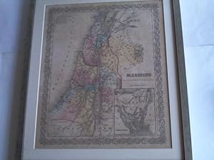
Palestine. Fl�chenkolorierte Karte im Kupferstich um 1855
Book
Gesamtgr��e 44 cm x 51,2 cm. Gr��e der Darstellung 35 cm x 41,5 cm. Fl�chenkolorierte Karte im Kupferstich unter Glas und Passepartout in bronzefarbenem Holzrahmen--- - Ma�stabsangaben in Meilen - 1605 Gramm.
-
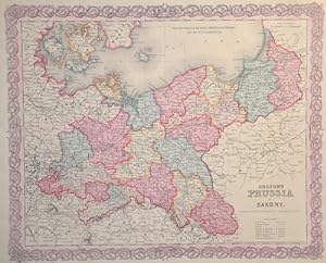
Colton's Prussia and Saxony.
Published by Artist: Colton/Hutchins Joseph ( - 1893 ) New York ; issued in: New York ; dated: 1855; - Joseph Hutchins Colton (1800 ?1893) known professionally as JH Colton founded an American mapmaking company which was an international leader in the map publishing industry between 1831 and 1890 For the first ten years Colton licensed the use of maps from established cartographers such as David H Burr Colton also employed some of the preeminent engravers of the time including Burr Samuel Stiles John Disturnell and D Griffing Johnson Colton went on to create railroad maps immigrant guides folding pocket maps large wall maps and elaborate atlases, 1800
Seller: Antique Sommer& Sapunaru KG, M�nchen, Germany
Seller Rating:

Technic: Steel engraving; colorit: original colored; condition: Perfect condition, size (in cm): 32 x 40 cm; - Surrounded by Colton's typical spiral motif border. Kaliningrad/K�nigsberg, Gda_sk/Danzig, Bromburg/Bydgoszcz, Posen, Wroc_aw/Breslau, Opole/Oppeln, Gorlitz, Dresden, Leipzig, Frankfurt (Oder), Szczecin/Stettin, Stralsund,Berlin, Magdeburg, Merseburg and Erfurt?.
-
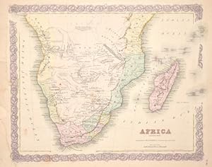
Africa (Sothern Sheet.)
Published by Artist: Colton/Hutchins Joseph ( - 1893 ) New York ; issued in: New York ; ca: 1855; - Joseph Hutchins Colton (1800 ?1893) known professionally as JH Colton founded an American mapmaking company which was an international leader in the map publishing industry between 1831 and 1890 For the first ten years Colton licensed the use of maps from established cartographers such as David H Burr Colton also employed some of the preeminent engravers of the time including Burr Samuel Stiles John Disturnell and D Griffing Johnson Colton went on to create railroad maps immigrant guides folding pocket maps large wall maps and elaborate atlases, 1800
Seller: Antique Sommer& Sapunaru KG, M�nchen, Germany
Seller Rating:
Technic: Lithography; colorit: original colored; condition: Tears at the external margin restored, size (in cm): 32 x 41 cm; - Map shows South Africa to the equator with Madagascar, the Seychelles, the Amirantes, Mauritius and the island of Reunion in the Indian Ocean.
-

New Brunswick Nova Scotia , Newfoundland and Prince Edward Id.
Published by Artist: Colton/Hutchins Joseph ( - 1893 ) New York ; dated: 1855; - Joseph Hutchins Colton (1800 ?1893) known professionally as JH Colton founded an American mapmaking company which was an international leader in the map publishing industry between 1831 and 1890 For the first ten years Colton licensed the use of maps from established cartographers such as David H Burr Colton also employed some of the preeminent engravers of the time including Burr Samuel Stiles John Disturnell and D Griffing Johnson Colton went on to create railroad maps immigrant guides folding pocket maps large wall maps and elaborate atlases, 1800
Seller: Antique Sommer& Sapunaru KG, M�nchen, Germany
Seller Rating:
Technic: Lithography; colorit: colored; condition: Very good, size (in cm): 32,5 x 40; - Map shows Nova Scotia, New Foundland and the Prince Edward island.
-
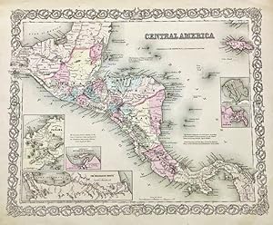
Condition: ACEPTABLE. [Un] "Mapa Colton" represetando la regi�n de Am�rica Central con insertos de Panam� y Nicaragua entre otros. En �l se detallancarreteras, caminos, v�as ferreaas, r�os, monta�as, etc., y lo decora una hermosa orla. Llevado a cabo porJoseph Hutchins Colton (1800-1893), uno de los cart�grafos estadounidenses m�s prol�ficos delsiglo XIX. Editado con el sello de Johnson & Browning, un a�o antes de que publicaranel famoso "Atlas Familiar Ilustrado"de Johnson. GW & CB Colton fue una importante empresa familiar de cart�grafos que lideraron el comercio de mapas en el siglo XIX en Estados Unidos. Su fundador, Joseph Hutchins Colton (1800-1893), e inaugur� el negocio editoria en Nueva York en 1831. Una de sus primeras piezas fue el c�lebremapa de la ciudad de Nueva York de John Disturnell en 1833.Para 1850 ya eran considerados una de las principales editoriales de gu�as tur�sticas y mapas de ferrocarriles, reconoblespor los grabados en placa de acero, con bordes decorativos y su particular acuareladoa mano. Formato (cm): 37,5x46.
-

Oceanica, Map Nr. 22 Coltons Common School Geography
Published by Artist: Colton/Hutchins Joseph ( - 1893 ) New York ; issued in: New York ; ca: 1850; - Joseph Hutchins Colton (1800 ?1893) known professionally as JH Colton founded an American mapmaking company which was an international leader in the map publishing industry between 1831 and 1890 For the first ten years Colton licensed the use of maps from established cartographers such as David H Burr Colton also employed some of the preeminent engravers of the time including Burr Samuel Stiles John Disturnell and D Griffing Johnson Colton went on to create railroad maps immigrant guides folding pocket maps large wall maps and elaborate atlases, 1800
Seller: Antique Sommer& Sapunaru KG, M�nchen, Germany
Seller Rating:
Technic: Wood engraving; colorit: colored; condition: Perfect condition, size (in cm): 21 x 27 cm; - Map shows total Oceania with Australia, New Zealand and Southeast Asia. on reverse 2 views of Oasis and Port Louis on Mauritius.
-
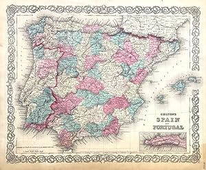
Condition: ACEPTABLE. [Un] Mapade la �poca de la Guerra Civil, representando la Pen�nsula Ib�rica y las Islas Baleares, con un detalle de Gibraltar inserto. En �l se detallancarreteras, caminos, v�as ferreaas, r�os, monta�as, etc., y lo decora una hermosa orla. Llevado a cabo porJoseph Hutchins Colton (1800-1893), uno de los cart�grafos estadounidenses m�s prol�ficos delsiglo XIX. Editado con el sello de Johnson & Browning, un a�o antes de que publicaranel famoso "Atlas Familiar Ilustrado"de Johnson. GW & CB Colton fue una importante empresa familiar de cart�grafos que lideraron el comercio de mapas en el siglo XIX en Estados Unidos. Su fundador, Joseph Hutchins Colton (1800-1893), e inaugur� el negocio editoria en Nueva York en 1831. Una de sus primeras piezas fue el c�lebremapa de la ciudad de Nueva York de John Disturnell en 1833.Para 1850 ya eran considerados una de las principales editoriales de gu�as tur�sticas y mapas de ferrocarriles, reconoblespor los grabados en placa de acero, con bordes decorativos y su particular acuareladoa mano. ["Published by G.W. C.B. Colton &Co. . New York."] Formato (cm): 37x44.
-

Colton's Railroad & Township Map of New York, with Parts of the Adjoining States & Canada
Published by New York: G. W. & C. B. Colton & Co., 1870., 1870
Folding lithographed map (28 x 25 inches) with original colour in full (some separations at lower folds). Original black cloth, gilt (worn with loss at the head of the spine). Later edition of a map with copyright date of 1852. As is typical with Colton maps, he constantly updated them, and this map stayed in print for several years after this edition. Rumsey 179 (listing the 1855 edition). Joseph Hutchins Colton had begun publishing maps in New York in the 1830s. Between 1831 and 1890, the Colton firm dominated American map publishing, although Colton had no formal training in geography or cartography; he began by purchasing copyrights of maps prepared by other individuals or companies, and his principal role was to manage the production and distribution of the maps. His first maps were drawn by the esteemed cartographer David H. Burr in the 1830s. By the 1850s Colton was also publishing guidebooks, atlases and immigrant and railroad maps. The firm was renamed G.W. & C.B. Colton in the 1860s when Colton was succeeded by his sons, George and Charles.
-
The Western Tourist, or Emigrants Guide, through the States, Etc. 1854 with Hand-Colored Map, in Near Fine Condition.
Published by J.H. Colton and Company, 1854
No Binding. Condition: Near Fine. Publisher: New York: , 1854., [1850] Used. 12mo., (6-1/8"x 3 7/8"). One page publisher's advertisement at front matter, publisher's catalog at end with 23 numbered pages and 4 not so. Large folding engraved map after J. Calvin Smith, with original hand-coloring in full (some light brown staining and short separations at folds). Map colors are distinct and very bright/vibrant, looking beautiful and in 'As New' condition. It was clearly never displayed in a lighted area. Original brown cloth stamped with titles and decorations, minor wear at a few corners and edges. An early pencil & light (flowing ink pen) short name to front endpaper. First published, in this edition, in 1850 according to the copyright page. Dated 1854 on the title page. An attractive-looking and conditionally near fine example of this early US guide with a wonderful hand-colored map. Photos available. Book.
-
Fine folding lithographed pocket map (16 6/8 x 13 4/8 inches) on bank note paper with original hand-colour in full, with an inset of Chicago lower left, and a key lower right (short closed tear near mount). Original red cloth, gilt (head and foot of the spine frayed). First published in this format, with the inset of Chicago, in 1855, by which time Chicago had become the state's capital and transport hub, linking the western counties to Lake Michigan with via an extensive rail network. From the early 1820s Illinois was one of the few states that discouraged slavery. As the birthplace of President Abraham Lincoln, the state was one of the earliest to show their support for the Civil War with the southern states.
-
The Western Tourist and Emigrant's Guide through the States of Ohio, Michigan, Indiana, Illinois, Missouri, Iowa, and Wisconsin, and the territories of Minesota, Missouri, and Nebraska
Published by New York: J.H. Colton and Company, 1854., 1854
12mo., (6 x 3 6/8 inches). One-page publisher s advertisement at beginning, publisher's catalogue at end (spotting and browned throughout). Large folding engraved map after J. Calvin Smith, with original hand-colour in full (some browning and short separations at folds). Original lilac cloth, gilt (faded, worn). Provenance: early pencil trials to endpapers. First published in 1839. "The great region of the North and West, comprehended in the states of Ohio, Michigan, Indiana, Illinois, Missouri, Iowa, and Wisconsin, and the territories of Minesota, Missouri, and Nebraska, is daily becoming more and more important and interesting. Its vast resources are in a state of rapid development. Industry and enterprise, aided by enlightened legislation, are calling forth its energies; and the prophetic declaration, that "westward the star of empire takes its way," is advancing to fulfillment. A few years ago this region, then denominated the "far west", was regarded as the outskirts of civilization it is now (at least the greater portion of it) the residence of an active, vigorous, and intelligent population. The steamboat, railroad car, and telegraph have become its great movers. Cities have sprung up in the wilderness as if by the will of the magician; agriculture, manufactures, and commerce flourish; literature, science, and the arts are extending their healthful and invigorating influence throughout the country. Blessed with a soil unsurpassed in fertility, and a salubrious climate; and possessing, by means of its great rivers and lakes, advantages for trade and commerce, it enjoys all the influences that can render a country prosperous and a people happy" (Publisher s Advertisement).
-
Colton's New Township Map of the Eastern Counties of Pennsylvania.
Published by New York: G.W. & C.B. Colton & Co., 1880., 1880
Folding engraved map of Pennsylvania, printed on two sheets and joined (40 � x 28 inches), original hand coloring in full (some tears at folds, but an ATTRACTIVE COPY of a fragile map). Original blue cloth, embossed in blind, lettered in gilt on front (extremities a bit rubbed, inner hinge slightly cracked). An ATTRACTIVE COPY of this detailed map of Pennsylvania, first published in 1866. Catalogued by Kate Hunter.
-

Colton's Traveler and Tourist's Guide-Book Through the United States Of America and the Canadas
Published by J. H. Colton, New York, 1850
First Edition
12 mo., (6 x 4 inches). 2 lithograph maps on bank note paper with original hand-color in outline: "The Rail Road Routes between New York, Philadelphia, Baltimore & Washington"; "Colton's Map of the United States the Canadas &c. Rail Roads, Canals, & Stage Roads with Distances from Place to Place", with fine vignettes of the "Isthmus of Panama Showing the Routes of Travel between Chagres & Panama"; "Map of the United States Central America &c." "Map of New England and Eastern New York" (numerous separations at folds, some of which have been professionally repaired). Original red cloth gilt cloth (expertly rebacked preserving the original spine, corners strengthened) Provenance: Contemporary penciled ownership inscription of W. S., Jane, Jas. Simonds on front pastedown. First edition of a popular guide book that went through many editions. "Essentially same as the various handbooks listed under Smith, John Calvin. Includes material on California, Oregon and Texas, with overland routes, etc." (Howes). This is a fairly extensive guide book for the entire United States, despite the fact the map shows only about half the country. Colton includes discussions of the Oregon Territory, California, Utah, New Mexico, and Texas. The section on California enthusiastically describes the climate and the Gold Regions, followed by a table describing routes from Fort Leavenworth to San Diego, Independence to Sacramento via South Pass, Independence to Oregon City, and Council Bluffs to Salt Lake City. The Texas section has a brief (but rare) reference to the ghost town of "Zodeac" (actually Zodiac), a short-lived Mormon settlement founded by Lyman Wight's splinter sect that protested Brigham Young's leadership after Joseph Smith's death and went searching for Zion in Texas. The large map shows Texas to slightly west of San Antonio (the border of Texas is still shown as the Sabine River). Two of the inset maps relate to the California Gold Rush. The upper inset shows the proposed line of the Panama Railroad; and the second inset of the U.S. shows the "Gold Regions" in California and the two overland routes from Independence, the northern route going to San Francisco via Salt Lake City, and the southern route going to San Diego via Santa Fe. Catalogued by Kate Hunter.
-
Fine folding lithographed pocket map on bank note paper with original hand-colour in full, (sheet size 16 x 13 4/8 inches), with an inset of the "City of San Francisco" 9one or two short tears at folds). Tipped-in to original brown blind-stamped cloth (extremities scuffed). Provenance: "Proposed R.R. from St. Francisco to Humboldt Bay" pencilled off the coast. "the best-known map of California in the eastern states during the 'fifties" (Wheat) First published, in 1853, and reprinted for Colton's "American Atlas". The inset of San Francisco shows projected land reclamation with streets named and extending into the yet to be reclaimed bay. Showing railroads, roads, cities, villages, gold diggings, springs, dry lakes, and more. The railroad surveys had recently been completed and the proposed and explored routes are shown. Humboldt Bay, the second largest bay in California, remained hidden from European explorers of the Californian coastline for nearly three hundred years. Sighted by the Russians in 1806, it was not until an overland expedition in 1849 provided the exact location. This discovery led to the 1850 founding of the settlement of Eureka on its shore by the Union and Mendocino Exploring (development) companies, providing the gold-miners in the Trinity area and the Sierras access to much needed shipping channels. Although the manuscript annotations to this map indicate that the idea of a railroad connecting Eureka to San Francisco was an early one, it was not until 1914 that Northwestern Pacific Railroad connected the two cities. OCLC 8672525; Rumsey 2885; Streeter Sale 2734; Wheat "Gold Region" 238, 254.
-

Map of the United States of America, The British Provinces, Mexico, The West Indies and Central America
Published by New York, 1852
Art / Print / Poster
Condition: ACEPTABLE. Ejemplar en perfecto estado del Mapa Colton de Am�rica, impreso en dos hojas de gran formato que se unen en un mapa de 86 x 108 cent�metros, mientras que habitualmente se encuentra despiezado, entelado y plegado .Margenes a�adidos para igualar el tama�o de los mapas del Atlas Choix de Adriveau-Goujon. Formato (cm): 86x108.
-
Folding lithographed map (13 4/8 x 16 4/8 inches) with original hand colour in outline and in part. Original brown cloth, gilt (front cover detached, worn). A later edition, but still a scarce map showing most of Texas and the United States south of the 34th parallel, first published in 1854, reissued in 1861, and with additions which include Spencer's Ranch, Fort Leaton, Eagle Pass, Palafox, Rio Grande City are all shown along the Texas border. Railroads are now shown running through Texas and across to California, and between Veracruz and Mexico City; the Texas and Pacific and the Southern Pacific railroads are named. Joseph Hutchins Colton had begun publishing maps in New York in the 1830s. Between 1831 and 1890, the Colton firm dominated American map publishing, although Colton had no formal training in geography or cartography; he began by purchasing copyrights of maps prepared by other individuals or companies, and his principal role was to manage the production and distribution of the maps. His first maps were drawn by the esteemed cartographer David H. Burr in the 1830s. By the 1850s Colton was also publishing guidebooks, atlases and immigrant and railroad maps. The firm was renamed G.W. & C.B. Colton in the 1860s when Colton was succeeded by his sons, George and Charles.
-
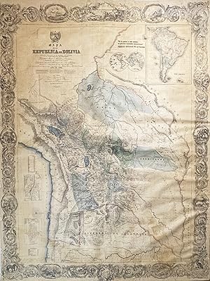
Mapa de la Republica de Bolivia mandado publicar pr el Gobierno de la Nacion en la Administracion del Presidente Doctor Jos� Maria Linares. Levantado y organindo en los anos de 1842 � 1859 Por el Teniente Coronel Juan Ondarza, Commandante Juan Mariano Mujia y Mayor Lucio Camacho.
Published by New York: J.H. Colton, ., 1859
Seller: Antiquariat Dasa Pahor GbR, M�nchen, Germany
Seller Rating:
Map
Lithographed map with full original hand colour, printed on 4 sheets and contemporarly joined and mounted upon old linen, rolled (slightly age-toned, light brown stain in the lower right part, minor scratches and folds on the surface, tiny pin holes in the margins), 182 x 140 cm (71.6 x 55.1 x inches). Very rare Juan Ondarza s large and highly detailed wall map of Bolivia, the first proper survey of the republic and one of the great monuments of the 19th Century cartography of Latin America, published by J.H. Colton in New York; at the centre of an entertaining, yet bizarre, story of intrepid Andean surveying, patriotic pride, financial scandal and earthquakes! - This spectacular wall map of Bolivia is one of the great landmarks of the cartography of Latin America. It represents the first accurate general survey of Bolivia and is by far the largest and most detailed map of the republic produced during the 19th Century. Interestingly, it also shows Bolivia with its territory at its maximum historical extent, before it ceded vast amounts of its landmass following wars and, in some cases, 'bizarre diplomatic incidents involving its neighbours. Printed by the leading American map publisher, Joseph Hutchins Colton, it is also the first national map produced in the United States at the behest of a foreign government (a practice that would become common later in the century). The story behind the map s production is a carnival of extraordinary events. It involves a dangerous 11 year-long reconnaissance of a one of the world s most rugged landscapes, the hindrance of the dissemination of the map by military coups and earthquakes, and a process that resulted in the bankruptcy of America s leading mapmaker. Bolivia was then a vast, geographically diverse and, in many parts, inhospitable land that spanned from the peaks of the Andes to the coastal Atacama Desert (the world s driest region) to the plateau of the Gran Chaco to the Amazonian Rainforest. The dramatic topography is vibrantly expressed through the use of hachures and shading, and the landscape is replete with details as to the locations of cities, towns, mines, rivers, roads, post offices, mountain ridges and other features. The republic s various departments are distinguished in full regional colours typical of the productions of the Colton firm, while the great Andean lakes of Titicaca and Poop� and the shores of the Pacific are coloured in brilliant blue. In the lower left corner of the map are detailed insets of La Paz (the main commercial centre of Bolivia), labeling 18 key sites and Sucre (the national capital), labeling 27 sites, along with a table noting the heights of the nation s major Andean peaks. In the upper right, the map features a large inset of South America, placing Bolivia within its greater geographical context. The title, in the upper left, is surmounted by the national coat of arms, while the map features an elegant border of spiraling acanthus scrolls, containing roundels featuring picturesque Bolivian scenes. The map is signed by Juan Ondarza Lara and his assistant Juan Mariano Mujia, in the lower left. The Bolivia portrayed on the map is far more expansive than it is in its current form. While the centre of the country as shown here, remains Bolivia today, the extremities on north, southeast and southwest are today all part of neighbouring countries. The northern Amazonian portion, along with a sliver of the Mato Grosso in the east, was ceded to Brazil in parts, in 1867 and 1903. The Coastal Atacama region was lost to Chile, following the War of the Pacific (1879-84) and the Gran Chaco region in the southeast was lost to Paraguay following the Chaco War (1932-35). SEE OUR WEB PAGE FOR A LONGER DESCRIPTION.
-
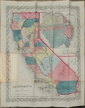
Single sheet, (17 � x 13 � inches). Publisher's Advertisement leaf mounted on inside front cover. Fine folding lithographed map with original hand color in full (some separation along folds, one or two spots). Original publisher's blindstamped red cloth gilt (a bit rubbed). Provenance: With library deaccession stamp of Union Theological Seminary Library to verso. With bookplate of American Bible Society (with stamp indicating deaccession). From the important cartographical library of Warren Heckrotte, his sale, Rare Cartography, Exploration and Voyages, Part II, December 3, 2015, Lot 119. First edition. With large inset of the City of San Francisco at upper right; 1853 census printed (or inkstamped?) on verso of map. First issue of J.H. Colton's little pocket map of California. Wheat notes that "This was probably the best-known map of California in the eastern states during the 'fifties. It was republished annually for a time, with little or no change." Warren Heckrotte describes various issues of the map in his notes: "This was reissued in 1854 as a separate, and also used to illustrate Capon's California. In 1855, it was copyrighted anew and was included in Colton's Atlas. The 1855 map was issued as a separate. The only difference I find between my 1853 issue and the 1854 issue in my copy of Capron, aside from different paper and some differences in color, is that at Nevada City, the 1853 issue has only 'Nevada'; the 1854 issue adds 'City.'" Mr. Heckrotte also states that "this map appears to be rare." Between 1831 and 1890, the Colton firm dominated American map publishing, and their atlases were the finest produced in the U.S. during the nineteenth century. The company was founded by Joseph Hutchins Colton (1800-1893), who had no formal training in geography or cartography; he began by purchasing copyrights of maps prepared by other individuals or companies, and his principal role was to manage the production and distribution of the maps. His first maps were drawn by the esteemed cartographer David H. Burr in the 1830s. By the 1850s Colton was also publishing guidebooks, atlases and immigrant and railroad maps. The firm was renamed G.W. & C.B. Colton in the 1860s when Colton was succeeded by his sons, George Woolworth Colton (1827-1901) and Charles B. Colton (c. 1831-1916). It is believed that George Colton compiled the company's 1855 Atlas of the World and served thereafter as the firm's principal map compiler, cartographer and engraver. The Colton firm refused to compromise quality, choosing to compete for sales in the more expensive international market rather than the cheap domestic one. For this reason, all maps were printed with steel plates, rather than as wax engravings, which was the most common method used at the time. OCLC/WorldCat locates eight copies of the map. Wheat Gold Region 238. Rumsey 2885. Streeter Sale 2734.
-
Folding lithographed map (13 4/8 x 16 4/8 inches) with original hand colour in outline and in part (some archival repairs to wormholes affecting the image). Original red cloth, gilt, title re-stamped in gilt in Spanish "Mapa de Mejico por J. H. Colton Nueva York" on the front cover (thumbed). Provenance: Ink library stamp of a school in Mataro Spain on the inside front cover and verso of the map. A later edition, but still a scarce map showing most of Texas and the United States south of the 34th parallel. In 1861 America was in the throws of Civil War and the Union Navy began a massive effort to blockade the Southern coast to prevent the movement of trade goods, supplies, and arms in and out of the Confederacy. In July, the U.S.S. South Carolina arrived off the coast of Galveston to begin the Union blockade in Texas. In July of 1861, the then president of Mexico Benito Juarez suspended all interest payments to foreign countries. What followed was a planned invasion of Mexico by France, initially supported by both Spain and Britain; being Mexico's largest creditors. Military intervention was further justified by France's Napoleon III on the grounds of maintaining a commitment to free trade. A French friendly government in Mexico would ensure European access to important markets, and prevent monopoly by the United States. It would also give France access to the valuable silver mines in Mexico. In October of 1861 the three nations singed an agreement: the Treaty of London, which united their efforts to receive payments from Mexico. On 8 December the Spanish fleet and troops from Spanish-controlled Cuba arrived at Mexico's main Gulf port, Veracruz. When the British and Spanish discovered that the French planned to invade Mexico, they withdrew their support. France went ahead with its occupation and the resulting Second Mexican Empire lasted from 1864-1867, with Archduke Ferdinand Maximilian of Austria on the Mexican Throne as Maximilian I of Mexico.
-
Provenance: early pencilled annotations to verso. VERY RARE: we can only find four copies of this issue and they are all in Texas. Apparently there is not a copy in the Library of Congress. First edition of Colton's map of Texas to show the information discovered by Charles W. Pressler which he first published in his celebrated map of 1858, and was not published by him again until 1862, with a pocket edition first being issued in 1879. "The accuracy of Pressler's map was a major improvement in presenting Texas geography, particularly in the western areas of the state where errors and guesswork had been common. Pressler emphasized the emerging political entities within the state, as well as accurately depicting the rivers, streams, and developing road system within the state" (Martin & Martin 46). "The 1861 Colton map of Texas is an exceptionally rare and geographically/planimetrically ground-breaking and progressive map from Colton's Texas sequence. Notably, while it does not 'clone' Pressler's geographic detail, it is the first Colton Texas map to extensively embrace many of the important features of Pressler's work - this is particularly evident in the West and Northwest regions of the state. however, one will notice that in some areas certain 'Cordovian' details persist (ie certain county boundaries, road patterns, etc.), and indeed there might be some isolated influences from other maps as well. So like the 1861 Richardson, the 1861 Colton is a melange that means that it is its own thing" (Alexander Johnson). In 1855 Jacob de Cordova had sold the rights to his important 1849 map of Texas to Colton, and Colton published that map in large format from 1855 to 1861. The copyright notice lower left clearly states that the present map was "Entered According to Act of Congress, in the Year 1855, by J.H. Colton & Co. in the Clerk's Office of the District Court of the United States, for the Southern District of New York". In all actuality this probably refers to Colton's map based on Cordova's, as entering a map based on Pressler's information at that date would have been impossible. In 1861 America was in the throws of Civil War and the Union Navy began a massive effort to blockade the Southern coast to prevent the movement of trade goods, supplies, and arms in and out of the Confederacy. In July, the U.S.S. South Carolina arrived off the coast of Galveston to begin the Union blockade in Texas. See Martin & Martin 39 and 46.
-
Folding lithographed map (17 x 25 inches) with original hand colour in full (some separations at folds). Original dark brown cloth, gilt (a bit rubbed). Rare pocket map version of Colton's map of Arizona and New Mexico, with parts of Nevada, California, the Mexican border, Kansas, Colorado, and Texas (western Panhandle and "Camp Stockton" and China Ponds to El Paso). Native American reservations, railroads (existing and proposed, including the Southern Pacific route), mining districts, forts, geological features, and many towns and villages are all shown. Although not shown on this map, peak production of the Comstock Lode in Nevada occurred in 1877, the year this map was published, with the mines producing over $14,000,000 of gold and $21,000,000 of silver that year. The previous year a rancher had found the Lake Valley silver deposits in Sierra County New Mexico, although the site is not marked on the map. Joseph Hutchins Colton had begun publishing maps in New York in the 1830s. Between 1831 and 1890, the Colton firm dominated American map publishing, although Colton had no formal training in geography or cartography; he began by purchasing copyrights of maps prepared by other individuals or companies, and his principal role was to manage the production and distribution of the maps. His first maps were drawn by the esteemed cartographer David H. Burr in the 1830s. By the 1850s Colton was also publishing guidebooks, atlases and immigrant and railroad maps. The firm was renamed G.W. & C.B. Colton in the 1860s when Colton was succeeded by his sons, George and Charles.
-
Map of the United States of America, the British Provinces, Mexico, the West Indies and Central America with part of New Granada and Venezuela.
Published by New York: J.H. Colton, 1849., 1849
Folding engraved map (34 x 42 inches) laid down on linen in 32 sections, as issued, with original hand-colour in outline, and in part, by John M. Atwood. With an inset map of the Atlantic Ocean lower left, the title beneath a fine engraved emblematic vignette of an eagle, all surrounded with a broad decorative border incorporating a grape vine interspersed with vignettes of national monuments by W. S. Barnard (some light spotting and browning); preserved in a red cloth folding box. Provenance: From the map-library of Mark Babinski, his sale Swann Galleries, 8th December 2005, lot 60. Second 1849 edition, differing from the first by the addition of the "El Dorado Gold Region" north of the Feather River in what is now California, and with John Charles Fremont's route shown along the Humboldt River in present day Nevada, but with the spelling of the word "capitol" under the large corner vignette, differing from the copies examined by Wheat and Rumsey. A fine, large scale map of the United States, and one of "the first to show the vast region added to our West by the Treaty of Guadalupe Hidalgo before it was apportioned to the new state of California and to the territories of New Mexico and Utah that were set up in 1850. This map is not in Phillips and should not be confused with the small Colton 1849 map listed on page 900. In this issue the "Gold Region" near New Helvetia, California, is indicated. Among the views are two Oregon scenes, "Astoria, Oregon," and "Willammette Falls, Orego" (Streeter). The map shows a large "Upper or New California", Nebraska and Oregon Territories, and features New Mexico Territory on the west side of Santa Fe. Texas extends on the west as far as Santa Fe and Albuquerque, and to Pike's Peak in the north. The gold regions in California are shown in yellow. An engraved annotation at the edge of Salt Lake declares this region to be a "Mormon Sett," and a "Mormon Fort" is shown nearby. Streeter 3873; cf Wheat, Maps of the Gold Region, 74.