Order Total (1 Item Items):
Shipping Destination:

Louis Larmat (5 results)
Skip to main search results
Search filters
Product Type
- All Product Types
- Books (5)
- Magazines & Periodicals (No further results match this refinement)
- Comics (No further results match this refinement)
- Sheet Music (No further results match this refinement)
- Art, Prints & Posters (No further results match this refinement)
- Photographs (No further results match this refinement)
- Maps (No further results match this refinement)
- Manuscripts & Paper Collectibles (No further results match this refinement)
Condition Learn more
- New (1)
- As New, Fine or Near Fine (2)
- Very Good or Good (2)
- Fair or Poor (No further results match this refinement)
- As Described (No further results match this refinement)
Binding
Collectible Attributes
- First Edition (No further results match this refinement)
- Signed (No further results match this refinement)
- Dust Jacket (No further results match this refinement)
- Seller-Supplied Images (4)
- Not Print on Demand (5)
Language (2)
Free Shipping
- Free Shipping to U.S.A. (No further results match this refinement)
Seller Location
Seller Rating
-

Condition: Neuf.
-
[Bordeaux Wine Maps] Atlas de La France Vinicole, Les Vins de Bordeaux.
Published by Louis Larmat, 1949
Seller: Barry Lawrence Ruderman, La Jolla, CA, U.S.A.
Seller rating 5 out of 5 stars

Hardcover. Condition: vg. Elaborate Cartographic Record of France's Bordeaux Wine Region: Codifying the Appellation d'Origine Contr l e (AOC) ClassificationsLouis Larmat's Les Vins de Bordeaux presents a detailed survey of Bordeaux's legendary vi. Original color pictorial card wrappers. [78] pages plus 16 colored maps (6 folding) and numeruos pages of b&w photographic plates. Spine ends bit chipped. Else a very clean nice example. Elaborate Cartographic Record of France's Bordeaux Wine Region: Codifying the Appellation d'Origine Contr l e (AOC) ClassificationsLouis Larmat's Les Vins de Bordeaux presents a detailed survey of Bordeaux's legendary vineyards. Originating from Larmat's pioneering efforts to map France's wine regions following the establishment of the AOC system in the 1930s, this atlas translates complex viticultural legislation into precise, color-coded cartography. Published under the high patronage of the Institut National des Appellations d'Origine, the work serves as an essential historical document, capturing the vineyard boundaries and terroir classifications of Burgundy as they were officially recognized in the post-war era.The publication context of Larmat's work is rooted in a monumental cartographic undertaking. During the 1940s, Larmat produced the Atlas de la France Vinicole in six folio volumes, universally recognized as the world's first comprehensive national wine atlas. This 1949 edition, issued in a large quarto format (designated on the title page as "Collection in-4 raisin"), incorporates updated maps that reflect post-war legislative refinements while retaining the exacting standards of the original folio production. The map sheets bear a 1949 copyright by L. Larmat.Cartographic Detail and Viticultural ClassificationThe atlas contains several richly detailed, folding color maps that graphically display Bordeaux's premier growing areas. The primary growing areas of the appellation are distinctly colored, standing in stark contrast to the neighboring regions.The maps are:Le Vins de Bordeaux. Carte G n rale"Les Vins de Bordeaux" Haut-M docM docGraves - Graves Sup rieursC ronsR gion de Sauternes et BarsacSt. Emilion"Le Vins de Bordeau"Pomerol.Lalande-de-Pomerol / N acCotes Canon-Fronsac / Cotes de FronsacLoupiac / Ste. Croix-du-Mont / Cotes de Bordeaux - St. MacairePremieres Cote de BordeauxEntre-Deux-Mers / Graves de Vayres / Ste.-Foy-BordeauxCotes de Bourg-BourgeaisIeres. Cotes de Blaye-BlayaisBeyond the strict cartographic survey, the volume features evocative imagery that celebrates the culture of French winemaking. Visual elements include an illustration of cellar workers managing large wooden barrels, lending a human dimension to the highly technical maps. Larmat's is a cornerstone reference for the enophile, the present volume highlighting one of the world's most celebrated wine-pro. Book.
-
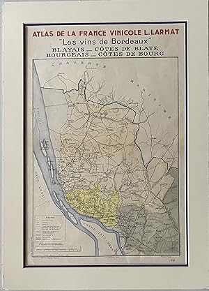
Atlas de la France Vinicole. "Les vins de Bordeaux, Blayais, C�tes de Blaye, Bourgeais, C�tes de Bourg.; English: The Atlas of France Winemaking. "The wines of Bordeaux" : Blayais, C�tes de Blaye, Bourgeais, C�tes de Bourg
Published by Les Proce�de�s Dorel, Paris, 1943
Seller: Sandra L. Hoekstra Bookseller, Thomaston, ME, U.S.A.
Association Member: ABAA ILAB IOBA MABA
Seller rating 4 out of 5 stars

Ephemera no binding. Condition: Fine. Louis Larmat, Paris, copyright. 27 7/8" x 19 7/8" mat size; 23 �" x 15 3/8" mat opening; 19" x 14" within the neat line; color map with legend; horizontal fold as issued; matted in off-white and dark purple; fine. Featuring two areas of Bordeaux, this is a lovely detailed map of French Bordeaux producing wine country. Purchased professionally double matted, it has not been removed from the mat and backing for examination.
-
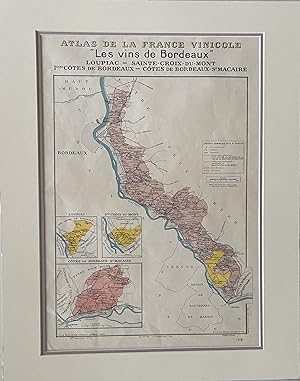
Atlas de la France Vinicole. "Les vins de Bordeaux" : Loupiac, Sainte-Croix-du-Mont, I�res C�tes de Bordeaux, C�tes de Bordeaux St. Macaire.; English: The Atlas of France Winemaking. "The wines of Bordeaux" : Entre-Deux-Mers, Graves de Vayres, and Sainte-Foy-Bordeaux
Published by Les Proce�de�s Dorel, Paris, 1941
Seller: Sandra L. Hoekstra Bookseller, Thomaston, ME, U.S.A.
Association Member: ABAA ILAB IOBA MABA
Seller rating 4 out of 5 stars
Ephemera no binding. Condition: Fine. [MAP]. Louis Larmat, Paris, copyright. 27 7/8" x 21 7/8" mat size; 22 7/8" x 15 7/8" mat opening; 18 7/8" x 14" within the neat line; color map with legend; horizontal fold as issued; matted in off-white and lavender; fine. Featuring three areas of Bordeaux, this is a lovely detailed map of French Bordeaux producing wine country. Purchased professionally double matted, it has not been removed from the mat and backing for examination.
-
Condition: Very Good. La c�te de Nuits.Les Vins de Bourgogne.Louis Larmat, Paris, 1942.Edition originale.Dimension 119,2 x 44,1 cm.Bon �tat, l�g�re oxydation aux plis.Publi�e dans le volume Les Vins de Bourgogne de l?Atlas de la France vinicole, la carte de la C�te de Nuits r�alis�e par Louis Larmat constitue l?une des repr�sentations les plus pr�cises et les plus embl�matiques du vignoble bourguignon au XXe si�cle. Elle offre une cartographie d�taill�e des communes et des climats prestigieux de la C�te de Nuits, tels que Gevrey-Chambertin, Vosne-Roman�e ou Chambolle-Musigny, en distinguant les crus selon un code couleur refl�tant leur hi�rarchie qualitative. Par la finesse de son trac� et la richesse de ses informations, cette carte t�moigne de l?effort de structuration et de reconnaissance des appellations d?origine contr�l�e en cours � cette �poque.Au-del� de son int�r�t propre, cette carte s?inscrit dans un projet �ditorial plus vaste : l?Atlas de la France vinicole de Larmat, entrepris entre 1941 et 1947, qui constitue l?une des premi�res tentatives de cartographie syst�matique des vignobles fran�ais. � la fois outil scientifique et objet esth�tique, cet atlas a durablement marqu� l?histoire de la repr�sentation des terroirs viticoles. Aujourd?hui, les cartes qui le composent, souvent extraites de leur volume d?origine, sont particuli�rement recherch�es pour leur valeur documentaire autant que pour leurs qualit�s graphiques.
![Seller image for [Bordeaux Wine Maps] Atlas de La France Vinicole, Les Vins de Bordeaux. for sale by Barry Lawrence Ruderman](https://pictures.abebooks.com/inventory/md/md32444197187.jpg)