Order Total (1 Item Items):
Shipping Destination:

Pieter Goos (54 results)
Skip to main search results
Product Type
- All Product Types
- Books (40)
- Magazines & Periodicals
- Comics
- Sheet Music
- Art, Prints & Posters
- Photographs
- Maps (14)
-
Manuscripts &
Paper Collectibles
Condition
Binding
- All Bindings
- Hardcover (16)
- Softcover
Collectible Attributes
Free Shipping
Seller Location
Seller Rating
-
![Stock image for De zee-atlas ofte water-wereldwaer in vertoont werden alle de zee-kusten van het bekende des aerd-bodems seer dienstigh voor alle heeren en kooplieden als oock voor alle schippers en stuurlieden [HARDCOVER] for sale by Books Puddle](https://pictures.abebooks.com/isbn/9789333302111-us-300.jpg)
Condition: New. pp. 103.
More buying choices from other sellers on AbeBooks
New offers from US$ 11.60
-
Map: Nieuwe Werelt Kaert Uyt Gegeven Tot Amsterdam By Pieter Goos (Facsimile)
Published by American Heritage, New York (Circa 1970?), 1970
Seller: Arroyo Seco Books, Pasadena, Member IOBA, Pasadena, CA, U.S.A.
Association Member: IOBA
Seller Rating:

Map
No Binding. Condition: Near Fine. No Jacket. Double Globe World Map Printed From The Original (illustrator). Reprint Published By American Heritage. Size: Image About 20 3/4" X 17" On Heavy Glossy Paper.
-
![Seller image for De zee-atlas ofte water-wereld : waer in vertoont werden alle de zee-kusten van het bekende des aerd-bodems : seer dienstigh voor alle heeren en kooplieden, als oock voor alle schippers en stuurlieden (1672) [LeatherBound] for sale by True World of Books](https://pictures.abebooks.com/inventory/md/md31657278886.jpg)
LeatherBound. Condition: New. LeatherBound edition. Condition: New. Reprinted from 1672 edition. Leather Binding on Spine and Corners with Golden leaf printing on spine. Bound in genuine leather with Satin ribbon page markers and Spine with raised gilt bands. A perfect gift for your loved ones. NO changes have been made to the original text. This is NOT a retyped or an ocr'd reprint. Illustrations, Index, if any, are included in black and white. Each page is checked manually before printing. As this print on demand book is reprinted from a very old book, there could be some missing or flawed pages, but we always try to make the book as complete as possible. Fold-outs, if any, are not part of the book. If the original book was published in multiple volumes then this reprint is of only one volume, not the whole set. Sewing binding for longer life, where the book block is actually sewn (smythe sewn/section sewn) with thread before binding which results in a more durable type of binding. Pages: 192 Goos, Pieter, ca. 1616-1675.
-

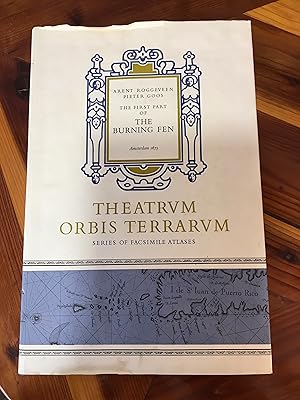
The Burning Fen First Part
Published by Theatrum Orbis Terrarum, Amsterdam Netherlands, 1971
ISBN 10: 902211029XISBN 13: 9789022110294
Book
Hardcover. Facsimile of 1675 Edition. This large valuable book will require extra shipping; please inquire. Pieter Goos' 1675 "Burning Fen the First Part" was the first pilot book containing charts of the Central America coasts and islands that appeared in print. This facsimile is Volume V in the Fifth Series by this pubisher. 68 pages, DJ edges slightly rubbed, one 1" tear, spine top has tiny chips (in mylar protector). ; 12 1/4 x 18 1/4 " Near Fine in Near Fine dust jacket.
More buying choices from other sellers on AbeBooks
Used offers from US$ 40.00
-
Hardcover. Condition: Fine. Dust Jacket Condition: Very Good. The Burning Fen First Part, hardcover, fine condition with minor wear to the dust jacket. Published in 1971.
-

The Burning Fen . The First Part [and] The Second Part.
Published by Amsterdam, Theatrum Orbis Terrarum 1970-1., 1970
Two volumes. Folio. Vol. I. 68pp.( 34 double-page charts) . Vol.II. 40pp. ( 22 double-page charts ). Original cloth in dustwrappers. Black and white illustrations; a near fine set. . Facsimile reprint of the 1675 Amsterdam edition. Theatrum Orbis Terrarum: Series of Atlases. Fifth Series Vols V and VI. " The first printed West Indian Pilot, published as a sequel to the three parts of Goos' well known "Sea Mirrour". It was the prototype of the pilot guides for America produced by Johannes van Keulen (1683) and John Seller and John Thornton (1689)".
-
Couverture rigide. Condition: Bon �tat. 2 volumes. Grand in-4 toil�, sous jaquette illustr�e. Nombreuses illustrations. facsimile atlas in-folio.
-

Riduzione della carta di Mercator & Hondius del 1633, a sua volta derivata da Magini. Si trova in 'Atlas minor, Das iszt: Eine kurtze jedoch gr�ndliche Beschreibung der gantzen Weldt. Scheda bibliografica tratta da 'Il territorio trentino-tirolese nell'antica cartografia' di Gino Tomasi, scheda n. 28. Formato: Incisione di 22x17 cm, in passepartout.
-
The Burning Fen. Two volumes; First Part: Amsterdam 1675. Second Part: Amsterdam 1687. Introduction by Dr. Ir C. Koeman. (Series of Atlases in Facsimile, Fifth Series, Volume V)
Published by Theatrum Orbis Terrarum Ltd, Amsterdam, 1971
Seller: J. HOOD, BOOKSELLERS, ABAA/ILAB, Baldwin City, KS, U.S.A.
Seller Rating:
Hardcover. [lg folios] Vol. l: 34 double-page charts and 70pp of text; Vol. 2: 18 double-page charts and 40pp. Fine / slightly torn & soiled djs. Fine / slightly torn & soiled djs.
-
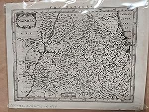
Navarra. Mapa
Published by circa 1628, Pa�ses Bajos, 1628
Seller: LIBRERIA ANTICUARIA LUCES DE BOHEMIA, ZARAGOZA, Spain
Seller Rating:
Mapa grabado, texto en el reverso en aleman. Escala [ca. 1:512.000], 4 leucae hispaniarum [=2,5 cm]; 4 milliaria Gallica communea [2,5 cm] 23,50x18 cm. (tama�o del papel).
-
Portrait of Eleazar Swalmius, theologician and priest in Amsterdam, seated on a chair, right hand on his chest. On the left a bookcase. After a painted portrait by Rembrandt. Under the portrait a poem by Geldorpius. Under the poem on the left: 'Rembrandt Pinxit'; 'I.Suijderhoef Sculpsit'; 'P. Goos Excudit' and 'H. Geldorpius'; below in the center in brown ink '387'. Book nr. 59578 other versionl Engraving with some etching; trimmed on platemark: 328 x 259 mm; total: 330 x 262 mm; state: I/3; Hollstein (Suyderhoef), p. 252, nr. 120. On the verso unidentified collector's mark. PP01S.
-
![Seller image for [Antique portrait print 1691] Portrait of theologician ELEAZARUS SWALMIUS, THEOLOGUS, ECCLESIASTES, AMSTELODAMENSIS. [.], published 1691, 1 p. for sale by Antiquariaat Arine van der Steur / ILAB](https://pictures.abebooks.com/inventory/md/md15097636252.jpg)
[Antique portrait print 1691] Portrait of theologician ELEAZARUS SWALMIUS, THEOLOGUS, ECCLESIASTES, AMSTELODAMENSIS. [.], published 1691, 1 p.
Seller: Antiquariaat Arine van der Steur / ILAB, Den Haag, Netherlands
Seller Rating:

Portrait of Eleazar Swalmius, theologician and priest in Amsterdam, seated on a chair, right hand on his chest. On the left a bookcase. After a painted portrait by Rembrandt. Under the portrait a poem by Geldorpius. Under the poem on the left: 'Rembrandt Pinxit'; 'I.Suijderhoef Sculpsit'; 'P. Goos Excudit' and 'H. Geldorpius'. Book nr. 59578 other version. Engraving with some etching; trimmed within platemark: 328 x 259 mm; state: I/3; Hollstein (Suyderhoef), p. 252, nr. 120. PP01S.
-
Portrait of Eleazar Swalmius, theologician and priest in Amsterdam, seated on a chair, right hand on his chest. On the left a bookcase. After a painted portrait by Rembrandt. Under the portrait a poem by Geldorpius. Under the poem on the left: 'Rembrandt Pinxit'; 'I.Suijderhoef Sculpsit'; 'P. Goos Excudit' and 'H. Geldorpius'. Book nr. 59578 other versionl Engraving with some etching; trimmed on platemark: 328 x 259 mm; total: 333 x 260 mm; state: I/3; Hollstein (Suyderhoef), p. 252, nr. 120. On the verso unidentified collector's mark. PP01S.
-
![Seller image for [ Sea Chart ] . " De Custen Van Engelant tusschen de twee pointen van Poortlandt en Lezard ". for sale by Roger Collicott Books](https://pictures.abebooks.com/inventory/md/md14338734973.jpg)
[ Sea Chart ] . " De Custen Van Engelant tusschen de twee pointen van Poortlandt en Lezard ".
Publication Date: 1650
Seller: Roger Collicott Books, Widecombe in the Moor, DEVON, United Kingdom
Seller Rating:
Map
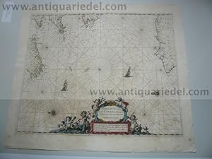
Map. Condition: Near Fine. From De Lichtende Columne Ofte Zee-Spiegel, published in Amsterdam. A rare early hand coloured sea chart of the English Channel from Lizard Point to Portland. Title contained within decorative cartouche, as is the mileage chart. A magnificent galleon, rhumb lines, and compass roses decorate the sea area. Attractive colouring.
-
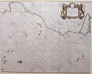
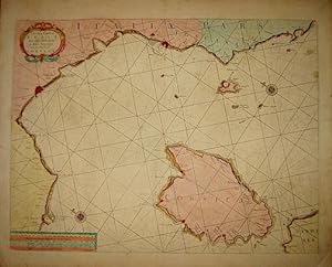
De Cust van Barbaria, Gualata, Arguyn, en Geneheo, van Capo S. Vincente tot Capo Verde.
Published by Pieter Goos, Amsterdam, 1665
Seller: Antiquariaat Dat Narrenschip, Middelburg, Netherlands
Seller Rating:
Map
No Binding. Condition: Near Fine. Nautical chart of the northwest coast of Africa, the Azores, Canary and Cape Verde Islands. Title cartouche with lion and leopard top right. Copper engraving with nice old color, published in Amsterdam by Pieter Goos around 1665 in 'De Nieuwe Groote Zeespiegel, (.).' Dimensions (picture) 43 x 52 cm.
-
Channel,Bay of Biscay, map, Pieter Goos, anno 1666, old colours
Published by Goos Pieter, 1616-1675, 1675
Hardcover. Condition: very good. Channel,Bay of Biscay, map, Pieter Goos, anno 1666, old colours Channel,Bay of Biscay, map, Pieter Goos, anno 1666, old colours Coppermap, edited by Pieter Goos in his Zee-Atlas, anno 1666, old colours, size of the leaf: 52 x 60 cm., little cracs on margins, clean print.
-
De Cust van Barbaryen van out Mamora tot Capo Blanco
Published by Jacques & Gasper Anthoine, Amsterdam, 1669
Seller: Argosy Book Store, ABAA, ILAB, New York, NY, U.S.A.
Seller Rating:
unbound. Sea chart. Uncolored copperplate engraving. Image measures 17 1/4" x 21 1/4". This rare sea chart by Pieter Goos features six charts of northwest Africa on one sheet. The upper chart covers the area once known as the Barbary Coast in Morocco, reaching from Mehdya, near Casablanca, in the north to Ras Nouadhibou (known as Cape Blanc or Cabo Blanco) in the south. The middle chart extends from Ras Nouadhibou along the coast of Western Sahara. The lower part features four insets with detailed charts of the islands of S�o Miguel, Faial, and Terceira in the Azores, and Madeira and Porto Santo in the Madeira Archipelago. In addition to ports, the map includes soundings, sand bars, fishing banks and navigational hazards. Each chart has rhumblines and its own title cartouche and embellished compass rose. This map was published in Goos' "De Zee-Atlas Ofte Water-Weereld" and remains in its original uncolored state, which allows Goos' intricate line work to shine. It is in good condition with slight foxing, soiling, and off-setting. Minor chips to lower margin not affecting the image. Pieter Goos (1616-1675) was a Dutch cartographer, engraver, publisher, printer, and print-seller based in Amsterdam. He belonged to a noted family of cartographers, headed by his father Abraham, who prepared plates for many maps published in the important atlases of the time. His pilot guide, the "Zee-Spiegel," provided some of the first charts of newly explored regions in the West Indies and Western Africa, and his "Zee-Atlas" is considered one of the best sea atlases of its time. This map is a fine example of Goos' high quality, visually appealing sea charts.
-
Cust van Hollant tusschen de Maes ende Texel
Published by Jacques & Gasper Anthoine, Amsterdam, 1669
Seller: Argosy Book Store, ABAA, ILAB, New York, NY, U.S.A.
Seller Rating:
unbound. Sea chart. Uncolored copperplate engraving. Image measures 17 1/4" x 21 1/4". This rare sea chart by Pieter Goos shows a section of the eastern coast of the Netherlands, covering the regions of present-day North and South Holland. It is oriented with north to the lower right and extends from the island of Texel in the north to the Hook of Holland in the south. At the center of the map is the Breeveertien, a large shallow area just off the coast that, today, is used as an offshore wind farm. In addition to ports, the map includes soundings, sand bars, fishing banks and navigational hazards. It also features rhumb lines, scales, a ship, and two embellished compass roses. The title cartouche and scales are decorated with scrollwork. This map was published in Goos' "De Zee-Atlas, Ofte Water-Weereld" and remains in its original uncolored state, which allows Goos' intricate line work to shine. It is in good condition with slight foxing, soiling, and off-setting. No chips or tears, although bottom corners are worn and the center seam is slightly separated, not affecting the image. Pieter Goos (1616-1675) was a Dutch cartographer, engraver, publisher, printer, and print-seller based in Amsterdam. He belonged to a noted family of cartographers, headed by his father Abraham, who prepared plates for many maps published in the important atlases of the time. His pilot guide, the "Zee-Spiegel," provided some of the first charts of newly explored regions in the West Indies and Western Africa, and his "Zee-Atlas" is considered one of the best sea atlases of its time. This map is a fine example of Goos' high quality, visually appealing sea charts.
-
Paskaarte om Achter Yrlandt om te Zeylen van Hitlant tot aen Heijbat
Published by Jacques & Gasper Anthoine, Amsterdam, 1669
Seller: Argosy Book Store, ABAA, ILAB, New York, NY, U.S.A.
Seller Rating:
unbound. Sea chart. Uncolored copperplate engraving. Image measures 19 7/8" x 22 3/4". This handsome sea chart by Pieter Goos depicts Ireland in its entirety, with the north oriented to the right. The chart also extends to parts of Scotland, England, and France. Also prominently featured are rhumb lines, scales, embellished tall ships, an elegant cartouche, and the harp crest for Ireland and the lion crest for Scotland. This map was published in Goos' "De Zee-Atlas Ofte Water-Weereld" and remains in its original uncolored state, which allows Goos' intricate line work to shine. It is in good condition with some foxing, soiling, and off-setting. Minor chips along border. Bottom of the center seam is separated. Pieter Goos (1616-1675) was a Dutch cartographer, engraver, publisher, printer, and print-seller based in Amsterdam. He belonged to a noted family of cartographers, headed by his father Abraham, who prepared plates for many maps published in the important atlases of the time. His pilot guide, the "Zee-Spiegel," provided some of the first charts of newly explored regions in the West Indies and Western Africa, and his "Zee-Atlas" is considered one of the best sea atlases of its time. This map is a classic example of Goos' high quality, visually appealing sea charts.
-
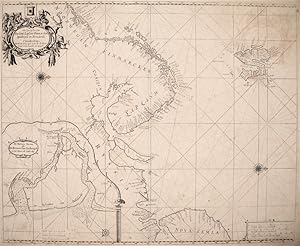
![Seller image for Pascaarte van Engelant Van 't Voorlant tot aen Blakeney waer in te sien is de mont vende Teemse [with] River van Londen for sale by Argosy Book Store, ABAA, ILAB](https://pictures.abebooks.com/inventory/md/md7622158188.jpg)
Pascaarte van Engelant Van 't Voorlant tot aen Blakeney waer in te sien is de mont vende Teemse [with] River van Londen
Published by Amsterdam, 1665
Seller: Argosy Book Store, ABAA, ILAB, New York, NY, U.S.A.
Seller Rating:
unbound. Map. Uncolored copperplate engraving. Image measures 17.5 x 21.5". This sea chart depicts the British Isles with North oriented to the right. The map extends to include the English Chanel and coastline of Normandy. In addition to ports, the index also includes soundings, sand bars, fishing banks and navigational hazards. Each region is adorned with a decorative coat of arms, and embellished compass roses appear at the top and bottom of the map. This map was published in Goos' "De Zee-Atlas Ofte Water-Weereld" and remains in its original uncolored state, which allows Goos' intricate line work to shine. It is in good condition with slight foxing, soiling, and off-setting. Pieter Goos (1616-1675) was a Dutch cartographer, engraver, publisher, printer, and print-seller based in Amsterdam. He belonged to a noted family of cartographers, headed by his father Abraham, who prepared plates for many maps published in the important atlases of the time. His pilot guide, the "Zee-Spiegel," provided some of the first charts of newly explored regions in the West Indies and Western Africa, and his "Zee-Atlas" is considered one of the best sea atlases of its time. This map is a fine example of Goos' high quality, visually appealing sea charts.
-
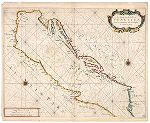
Zee-kaarte van de Golf van Venetien.
Publication Date: 1660
Map
Amsterdan, c.1660. Old colour. 410 x 530mm. A fine example of a scarce chart of the Adriatic, with the coasts of Italy north of Otranto and Brindisi, and Croatia, Montenegro and Albania.
-
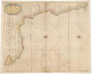
Pas-Caart van Guinea en de Custen daer Aen gelegen Van Cabo verde tot Cabo de Bona Esperanca.
Publication Date: 1680
Map
Amsterdam, c.1680. Old colour. 450 x 550mm. A little surface soiling. Decorative chart of West Africa from Cape Verde south to the Cape of Good Hope, orientated with north to the left. SHIRLEY: World, p. 456, 'Pieter Goos' marine atlases were held to be among the finest printed at the time and were often added to the nine or twelve volumes of Blaeu's Atlas Maior'.
-
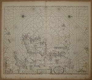
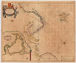
De Zee Custen van Ruslant, Laplant, Finmarcken, Spitsbergen en Nova Zemla
Published by Amsterdam, 1669
Seller: Argosy Book Store, ABAA, ILAB, New York, NY, U.S.A.
Seller Rating:
unbound. Sea chart. Uncolored copperplate engraving. Image measures 17.5" x 21.5". This rare sea chart by Pieter Goos shows the coasts of Russia and Finland with north oriented to the right. The islands of Spitsbergen and the tip of Novaya Zemlya are also visible. An inset map, oriented with north to the lower right, shows the River Dvina as it flows through the city of Arkhangelsk (Archangel), the chief seaport of Russia at the time. In addition to ports, the map includes topographical features, soundings, sand bars, fishing banks and navigational hazards. Around Spitsbergen particularly are detailed demarcations of safe anchorage points and whaling stations from when the islands were used as a whaling base. The map also features rhumb lines, scales, and embellished compass roses. A figured title cartouche adorned with scrollwork and feathers shows inhabitants and wildlife of the region. This map was published in Goos' "De Zee-Atlas, Ofte Water-Weereld" and remains in its original uncolored state, which allows Goos' intricate line work to shine. It is in good condition with slight foxing, soiling, and off-setting, particularly of the cartouche. Very few chips and tears. Pieter Goos (1616-75) was a Dutch cartographer, engraver, publisher, printer, and print-seller based in Amsterdam. He belonged to a noted family of cartographers, headed by his father Abraham, who prepared plates for many maps published in the important atlases of the time. His pilot guide, the "Zee-Spiegel," provided some of the first charts of newly-explored regions in the West Indies and Western Africa. His "Zee-Atlas" is considered one of the best sea atlases of its time. This map is a fine example of Goos' high-quality, visually appealing sea charts.
-
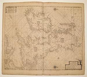
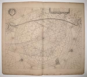
Pas-Caart vant Canaal Vertoonende in 't Gheheel Engelandt, Schotlandt, Yrlandt, en een Gedeelte van Vrancryck
Published by Amsterdam, 1669
Seller: Argosy Book Store, ABAA, ILAB, New York, NY, U.S.A.
Seller Rating:
unbound. Map. Uncolored copperplate engraving. Image measures 17.5 x 21.5". This sea chart depicts the British aisles with North oriented to the right. Centered on the Isle of Man, each countries coat of arms is included. Soundings, sand bars, fishing banks and navigational hazards are noted. The cross-staff is being used in the scale cartouche. It was a navigational tool used to measure the angle between the horizon and a celestial body such as the sun or stars. This map was published in Goos' "De Zee-Atlas Ofte Water-Weereld" and remains in its original uncolored state, which allows Goos' intricate line work to shine. It is in good condition with foxing, soiling, and off-setting, and small mis-fold lower center. Pieter Goos (1616-1675) was a Dutch cartographer, engraver, publisher, printer, and print-seller based in Amsterdam. He belonged to a noted family of cartographers, headed by his father Abraham, who prepared plates for many maps published in the important atlases of the time. His pilot guide, the "Zee-Spiegel," provided some of the first charts of newly explored regions in the West Indies and Western Africa, and his "Zee-Atlas" is considered one of the best sea atlases of its time. This map is a fine example of Goos' high quality, visually appealing sea charts. State 8 of 10 as indicated by the matching dates.
-
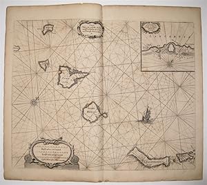
Caarte voor een gedeelte der Canarise Eylanden
Published by Jacques & Gasper Anthoine, Amsterdam, 1669
Seller: Argosy Book Store, ABAA, ILAB, New York, NY, U.S.A.
Seller Rating:
unbound. Sea chart. Uncolored copperplate engraving. Image measures 17 1/4" x 21 1/4". This rare sea chart by Pieter Goos shows the Spanish territory of the Canary Islands off the coast of northwest Africa. It encompasses, from left to right, El Hierro, La Palma, La Gomera, Tenerife, Gran Canaria, Fuerteventura, Isla de Lobos, Lanzarote, La Graciosa, Montaña Clara, and Alegranza. In addition to ports, the map includes soundings, sand bars, fishing banks and navigational hazards. It also features rhumb lines, scales, a ship, and an embellished compass rose, as well as a decorative title cartouche with scrollwork. An inset map shows the harbor of Lanzerote, an important 17th-century Dutch trading center, with another small cartouche and compass rose. This map was published in Goos' "De Zee-Atlas Ofte Water-Weereld" and remains in its original uncolored state, which allows Goos' intricate line work to shine. It is in good condition with slight foxing, soiling, and off-setting. Only small chips to edges, not affecting the image. Pieter Goos (1616-75) was a Dutch cartographer, engraver, publisher, printer, and print-seller based in Amsterdam. He belonged to a noted family of cartographers, headed by his father Abraham, who prepared plates for many maps published in the important atlases of the time. His pilot guide, the "Zee-Spiegel," provided some of the first charts of newly explored regions in the West Indies and Western Africa, and his "Zee-Atlas" is considered one of the best sea atlases of its time. This map is a fine example of Goos' high quality, visually appealing sea charts.
-
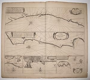
The Sea Coast of Italy from Cape Delle Melle to Mount Argentato with the Island of Corsica
Published by s.l. s.d. (seconda met� del ?600)
Seller: Libreria Ex Libris ALAI-ILAB/LILA member, Roma, Italy
Seller Rating:
Map
Carta geografica originale (cm. 52x40 pi� ampi margini) in bella coloritura coeva all'acquarello. Carta vergellata. Ottimo esemplare. Edizione inglese derivante dalla carta presente nel celebre atlante nautico 'Zee-Spiegel' di Pieter Goos. Rara.
-

Pascaerte van Groen-Landt, Yslandt, Straet Davids en Ian Mayen Eylandt; hoemen de selvige van Hitlandt en de Noortcusten van Schotlandt en Yrlandt beseylen mach.
Publication Date: 1670
Map
Amsterdan, c.1670. Coloured. 435 x 530mm. A Dutch chart of the North Atlantic, showing the British Isles (with the Channel Islands but without South East England) bottom right, clockwise to Jan Mayen Island, Iceland, Greenland, Davis Strait and Baffin Island, the Hudson Strait, Labrador and the northenmost tip of Newfoundland. Of interest are the the cartographical errors created by Martin Frobisher (c.1535-94), the Elizabethan sea captain knighted for his services against the Spanish Armada. Crossing southern Greenland is 'Martin Forbischers Straet' (actually an inlet on Baffin Island; and in the mid-Atlantic is 'Bus', for 'Buss Island', a phantom island reported by Frobisher's third expedition in 1587 and finally disproved by John Ross in 1818. BURDEN: 289, state 3 of 4.
-
Pas-Caart van Guinea en de Custen daer aen gelegan van Cabo verde tot Cabo de Bona Esperanza
Published by Amsterdam, 1666
Seller: Arader Galleries of Philadelphia, PA, Philadelphia, PA, U.S.A.
Seller Rating:
Book
N/A. Condition: Very Good. Dust Jacket Condition: N/A. Copper engraved sea chart with cartouche. Vivid hand color of the period with gilt highlighting. Sheet size: 22 1/8 x 26 1/2". Inventory#: p284pmat. The sea off the west coast of Africa between Cape Verde and the Cape of Good Hope. Goos' atlases are regarded as the best maritime works published in Amsterdam in the mid-17th century. Son of the engraver Adam Goos, he had the training to produce a highly artistic product in addition to a navigationally reliable one. His atlases were reprinted after his death with few revisions.
-
De cust van Barbaria, Gualata, arguyn, en Geneho, van Capo S. Vincente tot Capo Verde
Published by Amsterdam, 1666
Seller: Arader Galleries of Philadelphia, PA, Philadelphia, PA, U.S.A.
Seller Rating:
Book
N/A. Condition: Very Good. Dust Jacket Condition: N/A. Engraved coastal chart, outlined color highlighted in gilt of the period. Sheet size: 22 x 26". Inventory#: p285pmat. The Barbary Coast of north-western Africa with the offshore islands and the Strait of Gibraltar. In addition to the sea-atlases published partly with other Amsterdam chart-makers, Pieter Goos issued several collections of charts in atlas format. This is Chart 20 from the first edition of his popular Zoe-Atlas of 1666.
-
Die Zee Custen van Ruslant, Laplant, Finmarcken, Spitsbergen en Nova Zemla. t'Amsterdam, By Pieter Goos op't water by de Nieuwe brugh in de Vergulde Zee-Spiegel. De Reviere Dwina, oste De Reviere van Archangel soo het Nieuwe als 't Oude diep.
Published by Pieter Goos, Amsterdam, 1666
Seller: Antiquariat Reinhold Berg eK Inh. R.Berg, Regensburg, Germany
Seller Rating:
Map
Other. Copper engraving, finely hand colored in outline, when published. Partially heightened in gold. A highly decorative sea chart showing northern Scandinavia with the neighboring Russia and 'Nova Zemla'. Ornated in the upper left corner with a highly decorative finely hand colored title cartouche, in the lower left corner we do find an inset map of the river Dwina with Archangel. Printed on double thick paper. The paper slightly toned or stained. In very good to excellent condition. 443 by 541mm (17� by 21� inches).