
Order Total (1 Item Items):
Shipping Destination:

Spruner Menke (34 results)
Skip to main search results
Product Type
- All Product Types
- Books (21)
- Magazines & Periodicals
- Comics
- Sheet Music
- Art, Prints & Posters (13)
- Photographs
- Maps
-
Manuscripts &
Paper Collectibles
Condition
- All Conditions
- New
- Used
Binding
- All Bindings
- Hardcover (10)
- Softcover
Collectible Attributes
- First Edition
- Signed
- Dust Jacket
- Seller-Supplied Images (28)
- Not Printed On Demand
Seller Location
Seller Rating
-

Gotha, Justus Perthes, o. J. (ca. 1880), SS. 13 - 16 (Italien), SS. 29 - 32 (Frankreich), mit 8 doppelblattgro�en Farbkarten (kolorierte Kupferstiche) zu Italien (Nr. 21 - 28) und 7 doppelblattgro�en Farbkarten zu Frankreich (Nr. 51 - 57), 2�, Leinwand mit Goldpr�gung, Einbandecken stark besto�en bzw. mit aufgeplatzter Leinwand, am Buchr�cken fehlt die obere Leinwandschicht komplett (Klebehaftung des Buchblocks jedoch noch intakt), Einband auch etwas berieben, Bleistift-Vermerke auf Vorsatz, ohne Titelblatt, da Band nur die f�r Frankreich und Italien relevanten Text- und Bildteile enth�lt (diese aber vollst�ndig), Vors�tze leicht gebr�unt, Bl�tter am Rand leicht gebr�unt, Kartenr�ckseiten teils auch etwas st�rker gebr�unt , 1100 gr.
-
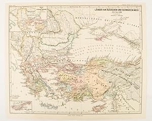
L�nder am �g�ischen und Schwarzen Meer 1311 bis 1390.
Published by Justus Perthes, Gotha, 1877
Seller: Asia Bookroom ANZAAB/ILAB, Canberra, ACT, Australia
Association Member: ANZAAB ILAB
Seller Rating:

Map with original colour and outline hand-colour, 32.2 x 40 cm, two inset maps, text in German, central fold, in very good condition. A most handsome map detailing countries on the Aegean and Black Seas 1311 to 1390. The inset maps depict the kingdom of Stephan Duschan (Serbia) and the land of the Crimean Goths, issued for the "Hand-Atlas f�r die Geschichte des Mittelatters und die Neueren Zeit".
-
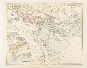
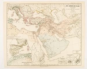
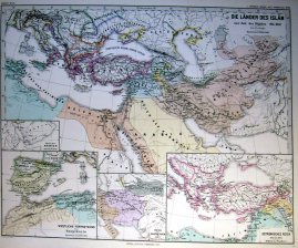
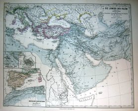
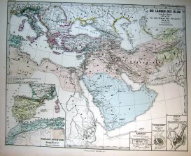
Die L�nder des Isl�m unter den Abb�siden bis zur Einnahme von Baghd�d durch die B�jiden 750 bis 945 n. Ch
Published by Justus Perthes, Gotha, 1877
Seller: Asia Bookroom ANZAAB/ILAB, Canberra, ACT, Australia
Association Member: ANZAAB ILAB
Seller Rating:
Map with original colour and outline hand-colour, 32.2 x 40 cm, three inset maps, text in German, central fold, slight marginal toning, in very good condition. A most handsome map detailing the lands of Islam under the Abbasids up to the capture of Baghd�d by the B�jids from 750 to 945 AD. The inset maps depict Northern Iraq, Baghdad, and a western continuation of the main map, issued for the "Hand-Atlas f�r die Geschichte des Mittelatters und die Neueren Zeit".
-
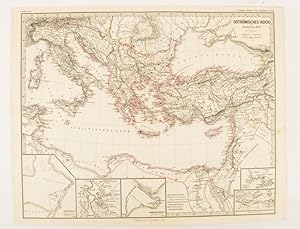
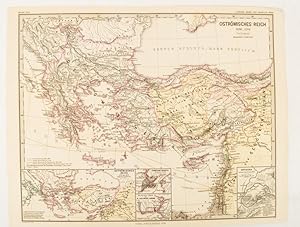
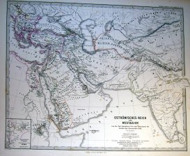
Ostr�misches Reich zu Justinians Zeit.
Published by Justus Perthes., Gotha.
Seller: Asia Bookroom ANZAAB/ILAB, Canberra, ACT, Australia
Association Member: ANZAAB ILAB
Seller Rating:
Map with original colour and outline hand-colour, 32.2 x 40 cm, text in German, five inset maps, central fold, slight marginal toning, and spotting on the verso, but in very good condition. A most handsome and highly detailed map detailing the Eastern provinces of the Byzantine/Roman Empire in the time of the Roman Emperor Justinian 527-565. The inset maps depict Carthage, Rome, Constantinople, Naples, and a Western continuation of the main map, originally issued for the "Hand-Atlas f�r die Geschichte des Mittelatters und die Neueren Zeit".
-
Ostr�misches Reich von der Einwanderung der Ungarn in Ponnonien um 895 bis zur Unterwerfung des Bulgarenreichs durch Kaiser Basilius im J. 1019.
Published by Justus Perthes, Gotha, 1874
Seller: Asia Bookroom ANZAAB/ILAB, Canberra, ACT, Australia
Association Member: ANZAAB ILAB
Seller Rating:
Map with original colour and outline hand-colour, 32.2 x 40 cm, three inset maps, text in German, central fold, slight marginal toning, in very good condition. A most handsome map detailing the Eastern Roman Empire from the immigration of Hungarians in Ponnonia around 895 to the subjugation of the Bulgarian Empire by Emperor Basilius in 1019. The inset maps depict Divisions of the Empire, Palestine, and the Themata around Propontis (present day Sea of Marmara), issued for the "Hand-Atlas f�r die Geschichte des Mittelatters und die Neueren Zeit".
-
Die L�nder des Isl�m von der Hegra 622 n. Ch. bis zum Sturze der Umaijaden 750 n. Ch.
Published by Justus Perthes, Gotha, 1877
Seller: Asia Bookroom ANZAAB/ILAB, Canberra, ACT, Australia
Association Member: ANZAAB ILAB
Seller Rating:
Map with original colour and outline hand-colour, 33.1 x 40.2 cm, four inset maps, text in German, central fold, slight marginal edge wear and spotting to the verso, but in very good condition. A handsome map detailing the lands of Islam from Hegra in AD 622 to the fall of the Umayyads in AD 750. The inset maps depict a western extension to the main map and city plans for Damascus, Jathrib & Medina, and Mecca, issued for the "Hand-Atlas f�r die Geschichte des Mittelatters und die Neueren Zeit".
-
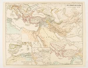
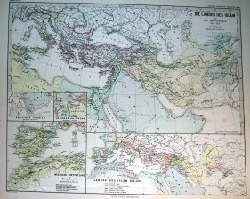
Die L�nder des Isl�m zur Zeit der B�jiden 945-1055.
Published by Justus Perthes, Gotha, 1877
Seller: Asia Bookroom ANZAAB/ILAB, Canberra, ACT, Australia
Association Member: ANZAAB ILAB
Seller Rating:
Map with original colour and outline hand-colour, 32.7 x 40.7 cm, four inset maps, text in German, central fold, slight marginal edge wear and spotting to the verso, but in very good condition. A handsome map detailing the lands of Islam at the time of the Bujids 945-1055. The inset maps depict a western extension to the main map, southern Arabia, the lands of the Ghaznavid sultanate in Central Asia, and lands of the Eastern Roman/Byzantine Empire, issued for the "Hand-Atlas f�r die Geschichte des Mittelatters und die Neueren Zeit".
-
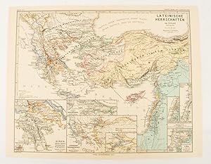
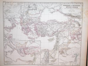
Lateinische Herrschaften im Orient 1210 bis 1311
Published by Justus Perthes, Gotha, 1876
Seller: Asia Bookroom ANZAAB/ILAB, Canberra, ACT, Australia
Association Member: ANZAAB ILAB
Seller Rating:
Map with original colour and outline hand-colour, 32.2 x 40 cm, seven inset maps, text in German, central fold, slight marginal toning, in very good condition. A most handsome and highly detailed map detailing provinces of the Latin Empire in the wake of the Crusades. The inset maps depict Achaia in Greece, Divisions of the Empire, and a city plan of Constantinople, issued for the "Hand-Atlas f�r die Geschichte des Mittelatters und die Neueren Zeit".
-
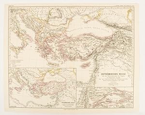
Ostr�misches Reich 1096-1204
Published by Justus Perthes, Gotha, 1876
Seller: Asia Bookroom ANZAAB/ILAB, Canberra, ACT, Australia
Association Member: ANZAAB ILAB
Seller Rating:
Map with original colour and outline hand-colour, 32.2 x 40 cm, text in German, four inset maps, central fold, slight marginal toning, and spotting on the verso, but in very good condition. A most handsome and highly detailed map detailing the Eastern provinces of the Byzantine/Roman Empire before the Fourth Crusade. The inset maps depict Constantinople, Divisions of the Empire, and Antioch, issued for the "Hand-Atlas f�r die Geschichte des Mittelatters und die Neueren Zeit".
-
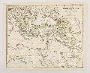
Osmanisches Reich und Seine Schutzstaaten.
Published by Justus Perthes (1880.), Gotha, 1880
Seller: Asia Bookroom ANZAAB/ILAB, Canberra, ACT, Australia
Association Member: ANZAAB ILAB
Seller Rating:
Map with original outline hand-colour, 35.4 x 44 cm (sheet), two inset maps showing Ottoman ruled states in North Africa, and the Arabian Gulf; central fold, some offsetting and browning, but the map in very good condition. Text in German. Historic map showing the extent of the Ottoman Empire in the 17th Century. Prepared as map 90 from the Spruner-Menke Handatlas.
-
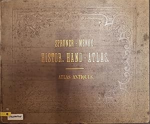
Atlas Antiquus. Historischer Atlas. Karoli Spruneri Opus (KARTENBAND)
Publication Date: 1865
Seller: books4less (Versandantiquariat Petra Gros GmbH & Co. KG), Welling, Germany
Seller Rating:
Book
Condition: Gut. 31 Karten; Das hier angebotene Kartenwerk stammt aus einer teilaufgel�sten wissenschaftlichen Bibliothek und tr�gt die entsprechenden Kennzeichnungen (R�ckenschild, Instituts-Stempel.); Einbandkanten sind leicht besto�en; Titelblatt besch�digt; der Zustand ist ansonsten ordentlich und dem Alter entsprechend gut. Sprache: Deutsch Gewicht in Gramm: 1800 Hardcover-Gro�format; ca. 48 x 40 cm;
-
Atlas Antiquus. Karoli Spruneri Opus, tertio edidit Theodorus Menke (3. Auflage).
Published by Perthes, Gotha,, 1865
Seller: Antiquariat Winfried Scholl (VDA/ILAB), Osnabr�ck, Germany
Seller Rating:

Folio. Doppelblattgro�er Titel, 17 S., 31 doppelblattgro�e Kartentafeln mit Grenzkolorit. Halbleder der Zeit mit goldgepr�gtem R�ckentitel. Einband beschabt, R�ckenbezug am Fu� l�diert. Alter Besitzvermerk auf Vorsatz. Textteil leicht gebr�unt, wenige Karten fleckig oder im Seitenfu� mit kurzem Einriss im Falz. Insgesamt recht ordentlicher Zustand. Beide Abteilungen in einem Band.
-
Atlas Antiquus. Karoli Spruneri Opus, tertio edidit Theodorus Menke. 3. Auflage.
Published by Gotha Perthes, 1865
Seller: Antiquariat Uwe-Karsten Kramm, Stuttgart, Stuttgart, BW, Germany
Seller Rating:

Gr.-4�. Doppelblatt-Titel, 13 nnr. Bl�tter, 31 Doppelblattgr. Karten. Schlichter Halbleineneinband der Zeit. Etwas berieben und besto�en. R�cken mit kleinen Fehlstellen im Leinen. Karten stellenweise etwas gebr�unt, aber sauber und unbesch�digt. *Zwei Abteilungen in 8 Lieferungen. 31 grenzkolorierte gestochene Karten. Sprache: Deutsch 3000 gr.
-
Atlas Antiquus. Karoli Spruneri Opus.
Published by Gotha: Perthes,, 1865
Seller: Altstadt-Antiquariat Nowicki-Hecht UG, Leer, NDS, Germany
Association Member: GIAQ
Seller Rating:
Book
Condition: Gut. Tertio editit Theodor Menke;. 17 S. Erl�uterungen zu den folgenden 31 doppelseitigen farbigen Karten; Dritte (3.) Ausgabe / Auflage; Einband berieben und besto�en, kl. Fehlstellen an d. Kapitalen, im Block sehr guter Zustand. (Schlagw�rter: Atlas, Kartenwerk, Geschichtsatlas) /atlas Sprache: Deutsch Gewicht in Gramm: 2100 2�; gebunden, Orig.-Leinen mit Goldpr�gung;
-
[ATLAS] SPRUNER-MENKE HAND-ATLAS FUR DIE GESCHICHTE DES MITTELALTERS UND DER NEUREN ZEIT DRITTE AUFLAGE
Published by Justus Perthes, Gotha, 1880
Seller: BLACK SWAN BOOKS, INC., ABAA, ILAB, Richmond, VA, U.S.A.
Association Member: ABAA ESA ILAB
Seller Rating:
Hard Cover. Condition: Near Fine binding. Folio; rebound in green cloth with titling in gold to the spine; [ii],[2], 3-42 pages, followed by 89 of 90 double-paged maps [NOTE: this copy appears to be lacking Map VIII: Europa wahrend des Zeitraums der Reformation und der Uebermachtdes Hauses Hapsburgh 1492-1618]; the maps are steel-engraved, with coloring to the borders of the countries; one maps in color lithography.~~This copy is bound quite tightly -- so tightly that it does not lie flat when opened and to the extent that some text and perhaps some part of maps are down in the gutter. Near Fine binding.
-
Die lander des Islam zur Zeit der Bujiden 945-1055 / Arabien / Grazneviden / Ostromisches Reich.
Published by Gotha, 1877
Art / Print / Poster
Condition: ACEPTABLE. Atlas Spruner-Menke, 1880 Gotha : Justus Perthes. 1877 Incluye peque�o mapa de Espa�a Formato (cm): 46x38.
-
Die Lander des Islam zur Zeit der Selguken 1055-1163 / Edessa .
Published by Gotha, 1877
Art / Print / Poster
Condition: ACEPTABLE. Atlas Spruner-Menke, 1880 Gotha : Justus Perthes. 1877 Incluye peque�o mapa de Espa�a Formato (cm): 46x38.
-
Die Lander des Islam unter den Abbasiden.750 bis 945 n. Ch / Nordliches Irak / Baghdad.
Published by Gotha, 1877
Art / Print / Poster
Condition: ACEPTABLE. Atlas Spruner-Menke, 1880 Gotha : Justus Perthes. 1877 Incluye peque�o mapa de Espa�a Formato (cm): 46x38.
-
Die Lander des Islam von der Hegra 622 n. Ch. 750 n. Ch. / Damascus / Medina / Mekka.
Published by Gotha, 1877
Art / Print / Poster
Condition: ACEPTABLE. Atlas Spruner-Menke, 1880 Gotha : Justus Perthes. 1877 Incluye peque�o mapa de Espa�a Formato (cm): 46x38.
-

Lateinische Herrschaften im Orient 1219 bis 1311 / Achaia / Constantinopel / Tyrus.
Published by Gotha, 1876
Art / Print / Poster
Condition: ACEPTABLE. Atlas Spruner-Menke, 1880 Gotha : Justus Perthes. 1876 Formato (cm): 46x38.
-
Ostromisches Reich und Westasien von der Zeit Justinians.642
Published by Gotha, 1871
Art / Print / Poster
Condition: ACEPTABLE. Atlas Spruner-Menke, 1880 Gotha : Justus Perthes. 1871 Formato (cm): 46x38.
-
Condition: ACEPTABLE. Atlas Spruner-Menke, 1880 Gotha : Justus Perthes. 1876 Formato (cm): 46x38.
-
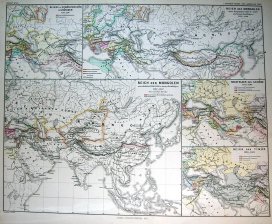
Reich der Mongolen / Nachfolger der Ilkhane / Reich des Timur
Published by Gotha, 1877
Art / Print / Poster
Condition: ACEPTABLE. Atlas Spruner-Menke, 1880 Gotha : Justus Perthes. 1877 Formato (cm): 46x38.
-
Sammelband:1. Orbis antiqui descriptio. 2. Historisch-Geographischer Schul-Atlas.
Published by Gotha, Perthes, 1854 u. 1856., 1854
Book
Durchgehend mit XVII und XXII ganzseitigen Karten. Einb. mit Gebrauchsspuren, Vorsatz u. Titelblatt mit Knickspuren, Vermerk auf Vorsatz, Seiten etw. fingerfl. u. teilw. braunfl. Sprache: Deutsch Quer-4�, goldgepr. Orig.-Halbleder.
-
Condition: ACEPTABLE. Atlas Spruner-Menke, 1880 Gotha : Justus Perthes. 1871 Formato (cm): 46x38.
-
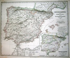
Iberische Halbinsel.kirchlichen Eintheilung.Maurischen Zeit
Published by Gotha, 1871
Art / Print / Poster
Condition: ACEPTABLE. Atlas Spruner-Menke, 1880 Gotha : Justus Perthes. 1871 Formato (cm): 46x38.
-
Condition: ACEPTABLE. Atlas Spruner-Menke, 1880 Gotha : Justus Perthes. 1871 Incluye un peque�o mapa de Navarra y Vascongadas y otro de Portugal Formato (cm): 46x38.
-
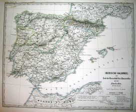
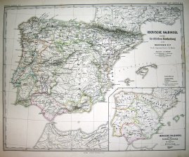
Iberische Halbinsel zur Zeit der Herrschaft der Almoraviden un der Almohaden
Published by Gotha, 1871
Art / Print / Poster
Condition: ACEPTABLE. Atlas Spruner-Menke, 1880 Gotha : Justus Perthes. 1871 Formato (cm): 46x38.
-
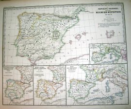
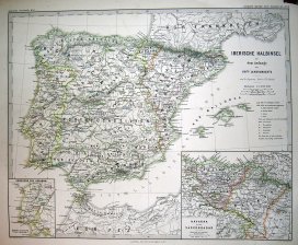
Condition: ACEPTABLE. Atlas Spruner-Menke, 1880 Gotha : Justus Perthes. 1871 Incluye 4 peque�os mapas de Espa�a con parte de Europa Formato (cm): 46x38.
-
Atlas Antiquus. Karoli Spruneri Opus - Tertio Editit. Theodorus Menke.
Published by Gothae : Sumtibus Justi Perthes, Gothae : Sumtibus Justi Perthes, 1865
17 pages de texte en allemand, imprim� sur 2 colonnes, avec 31 planches de cartes sur pages doubles, mont�es sur onglets et d�licatement rehauss�es ; couverture orn�e des titres en lettres dor�es ; dos � 4 nerfs avec filets et titres or ; toutes tranches mouchet�es bleues. in-folio Faibles taches sur le dernier plat, coiffes un peu us�es avec petit manque de cuir, sinon excellent �tat. reli�, demi-cuir marron � coins, et plats de toile bleue,

![Seller image for [ATLAS] SPRUNER-MENKE HAND-ATLAS FUR DIE GESCHICHTE DES MITTELALTERS UND DER NEUREN ZEIT DRITTE AUFLAGE for sale by BLACK SWAN BOOKS, INC., ABAA, ILAB](https://pictures.abebooks.com/inventory/md/md31703818409.jpg)