Order Total (1 Item Items):
Shipping Destination:

Victor Levasseur (451 results)
Feedback
Skip to main search results
Search filters
Product Type
- All Product Types
- Books (244)
- Magazines & Periodicals (No further results match this refinement)
- Comics (No further results match this refinement)
- Sheet Music (No further results match this refinement)
- Art, Prints & Posters (48)
- Photographs (No further results match this refinement)
- Maps (158)
- Manuscripts & Paper Collectibles (1)
Condition Learn more
Binding
Collectible Attributes
- First Edition (6)
- Signed (No further results match this refinement)
- Dust Jacket (No further results match this refinement)
- Seller-Supplied Images (389)
- Not Print on Demand (441)
Language (4)
Free Shipping
Seller Location
Seller Rating
-

Condition: New.
-
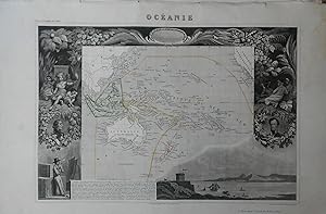
Atlas Universel Illustr�: Oc�anie
Published by A. Combette, Paris, 1856
Language: French
Seller: Stephen Peterson, Bookseller, Eden Prairie, MN, U.S.A.
Seller rating 5 out of 5 stars

Map
No Binding. Condition: Good. 21"X14.5" map of Oc�anie from Atlas Universel Illustr�; illustrated by Raimond Bonheur and engraved by Fr�d�ric-Guillaume Laguillermie. Map has minor soiling, faint staining in margins, and a number of short, edge tears.
-
US$ 7.57
Convert currencyUS$ 13.35 shipping from United Kingdom to U.S.A.Quantity: 1 available
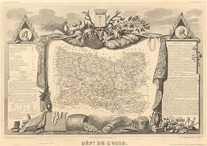
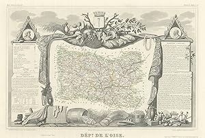
Add to basketCondition: Good. D�partement de l'OISE. Decorative antique map/carte by Victor LEVASSEUR 1852. Antique steel engraved map with outline hand colour (color) applied at the time of printing. Wide margins; V Levasseur (c1852). 29.5 x 42.0cm, 11.5 x 16.5 inches. Condition: Good. The image shown may have been taken from a different example of this map than that which is offered for sale. The map you will receive is in good condition but there may be minor variations in the condition from that shown in the image. This map was coloured by hand at the time of publication, thus the colouration may vary slightly between different examples of the map; the colouring applied to the map you receive may differ slightly from that shown in the image. There is nothing printed on the reverse side, which is plain.
-
US$ 8.25
Convert currencyUS$ 13.35 shipping from United Kingdom to U.S.A.Quantity: 7 available
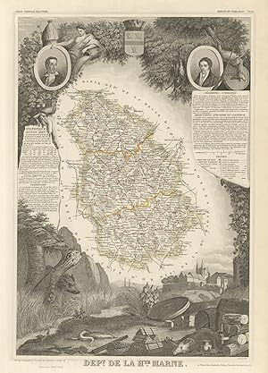
Add to basketCondition: Good. D�partement de la HAUTE-MARNE. Decorative antique map/carte. LEVASSEUR 1856. Antique steel engraved map with outline hand colour (color) applied at the time of printing. Wide margins; Victor Levasseur (1856). 42.0 x 28.5cm, 16.5 x 11.25 inches. Condition: Good. The image shown may have been taken from a different example of this map than that which is offered for sale. The map you will receive is in good condition but there may be minor variations in the condition from that shown in the image. This map was coloured by hand at the time of publication, thus the colouration may vary slightly between different examples of the map; the colouring applied to the map you receive may differ slightly from that shown in the image. There is nothing printed on the reverse side, which is plain.
-
US$ 8.25
Convert currencyUS$ 13.35 shipping from United Kingdom to U.S.A.Quantity: 4 available
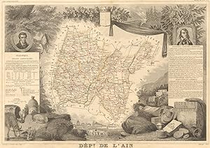
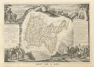
Add to basketCondition: Good. D�partement de l'AIN. Decorative antique map/carte by Victor LEVASSEUR 1852. Antique steel engraved map with outline hand colour (color) applied at the time of printing. Wide margins; V Levasseur (c1852). 29.5 x 42.0cm, 11.75 x 16.5 inches. Condition: Good. The image shown may have been taken from a different example of this map than that which is offered for sale. The map you will receive is in good condition but there may be minor variations in the condition from that shown in the image. This map was coloured by hand at the time of publication, thus the colouration may vary slightly between different examples of the map; the colouring applied to the map you receive may differ slightly from that shown in the image. There is nothing printed on the reverse side, which is plain.
-
US$ 8.25
Convert currencyUS$ 13.35 shipping from United Kingdom to U.S.A.Quantity: 1 available
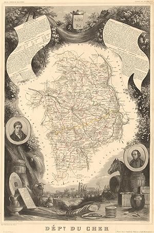
Add to basketCondition: Good. D�partement du CHER. Decorative antique map/carte by Victor LEVASSEUR 1852. Antique steel engraved map with outline hand colour (color) applied at the time of printing. Wide margins; V Levasseur (c1852). 43.5 x 28.5cm, 17 x 11.25 inches. Condition: Good. The image shown may have been taken from a different example of this map than that which is offered for sale. The map you will receive is in good condition but there may be minor variations in the condition from that shown in the image. This map was coloured by hand at the time of publication, thus the colouration may vary slightly between different examples of the map; the colouring applied to the map you receive may differ slightly from that shown in the image. There is nothing printed on the reverse side, which is plain.
-
US$ 8.25
Convert currencyUS$ 13.35 shipping from United Kingdom to U.S.A.Quantity: 4 available
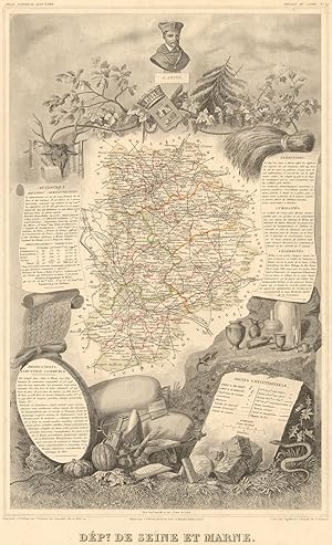
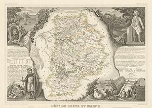
Add to basketCondition: Good. D�partement de SEINE-ET-MARNE. Decorative antique map/carte. LEVASSEUR 1852. Antique steel engraved map with outline hand colour (color) applied at the time of printing. Wide margins; V Levasseur (c1852). 46.5 x 28.0cm, 18.25 x 11 inches. Condition: Good. The image shown may have been taken from a different example of this map than that which is offered for sale. The map you will receive is in good condition but there may be minor variations in the condition from that shown in the image. This map was coloured by hand at the time of publication, thus the colouration may vary slightly between different examples of the map; the colouring applied to the map you receive may differ slightly from that shown in the image. There is nothing printed on the reverse side, which is plain.
-
US$ 8.25
Convert currencyUS$ 13.35 shipping from United Kingdom to U.S.A.Quantity: 4 available
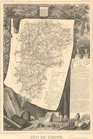
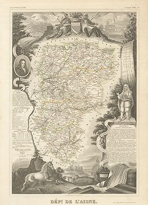
Add to basketCondition: Good. D�partement de l'AISNE. Decorative antique map/carte by Victor LEVASSEUR 1852. Antique steel engraved map with outline hand colour (color) applied at the time of printing. Wide margins; V Levasseur (c1852). 43.5 x 29.0cm, 17 x 11.25 inches. Condition: Good. The image shown may have been taken from a different example of this map than that which is offered for sale. The map you will receive is in good condition but there may be minor variations in the condition from that shown in the image. This map was coloured by hand at the time of publication, thus the colouration may vary slightly between different examples of the map; the colouring applied to the map you receive may differ slightly from that shown in the image. There is nothing printed on the reverse side, which is plain.
-
US$ 8.25
Convert currencyUS$ 13.35 shipping from United Kingdom to U.S.A.Quantity: 3 available
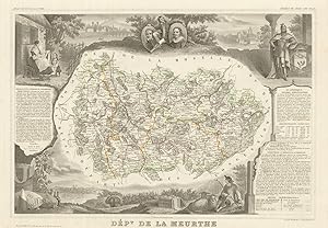
Add to basketCondition: Good. D�partement de la MEURTHE. Decorative antique map/carte. Victor LEVASSEUR 1852. Antique steel engraved map with outline hand colour (color) applied at the time of printing. Wide margins; V Levasseur (c1852). 31.0 x 42.5cm, 12.25 x 16.75 inches. Condition: Good. The image shown may have been taken from a different example of this map than that which is offered for sale. The map you will receive is in good condition but there may be minor variations in the condition from that shown in the image. This map was coloured by hand at the time of publication, thus the colouration may vary slightly between different examples of the map; the colouring applied to the map you receive may differ slightly from that shown in the image. There is nothing printed on the reverse side, which is plain.
-
US$ 5.95
Convert currencyUS$ 23.10 shipping from France to U.S.A.Quantity: 1 available
Add to basketPARIS, chez l'�diteur [15, rue de la Parchemine /// Imprimerie de Lemercier] - s.d. (XIXe) - Carte grav�e en noir et rehauss�e en couleurs [32,5x49,5 cm] et illustr�e par A. M. Perrot et Raimond Bonheur, avec "Statistiques" et l�gendes. Pliure centrale. Bon �tat. Tir�e de l'"Atlas National Illustr�" par V. Levasseur. Fran�ais Cartes g�ographiques.
-
US$ 8.95
Convert currencyUS$ 13.35 shipping from United Kingdom to U.S.A.Quantity: 2 available
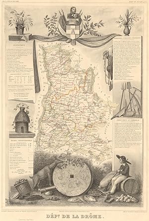
Add to basketCondition: Good. D�partement de la DR�ME. Decorative antique map/carte by Victor LEVASSEUR 1852. Antique steel engraved map with outline hand colour (color) applied at the time of printing. Wide margins; V Levasseur (c1852). 44.5 x 30.0cm, 17.5 x 11.75 inches. Condition: Good. The image shown may have been taken from a different example of this map than that which is offered for sale. The map you will receive is in good condition but there may be minor variations in the condition from that shown in the image. This map was coloured by hand at the time of publication, thus the colouration may vary slightly between different examples of the map; the colouring applied to the map you receive may differ slightly from that shown in the image. There is nothing printed on the reverse side, which is plain.
-
US$ 8.95
Convert currencyUS$ 13.35 shipping from United Kingdom to U.S.A.Quantity: 2 available
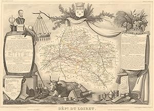
Add to basketCondition: Good. D�partement du LOIRET. Decorative antique map/carte by Victor LEVASSEUR 1852. Antique steel engraved map with outline hand colour (color) applied at the time of printing. Wide margins; V Levasseur (c1852). 30.0 x 41.5cm, 11.75 x 16.25 inches. Condition: Good. The image shown may have been taken from a different example of this map than that which is offered for sale. The map you will receive is in good condition but there may be minor variations in the condition from that shown in the image. This map was coloured by hand at the time of publication, thus the colouration may vary slightly between different examples of the map; the colouring applied to the map you receive may differ slightly from that shown in the image. There is nothing printed on the reverse side, which is plain.
-
US$ 8.95
Convert currencyUS$ 13.35 shipping from United Kingdom to U.S.A.Quantity: 2 available
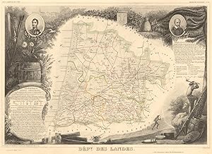
Add to basketCondition: Good. D�partement des LANDES. Decorative antique map/carte by Victor LEVASSEUR 1852. Antique steel engraved map with outline hand colour (color) applied at the time of printing. Wide margins; V Levasseur (c1852). 31.0 x 42.5cm, 12 x 16.75 inches. Condition: Good. The image shown may have been taken from a different example of this map than that which is offered for sale. The map you will receive is in good condition but there may be minor variations in the condition from that shown in the image. This map was coloured by hand at the time of publication, thus the colouration may vary slightly between different examples of the map; the colouring applied to the map you receive may differ slightly from that shown in the image. There is nothing printed on the reverse side, which is plain.
-

Lithographie d�partementale extraite de L'Atlas National Illustr� des 86 d�partements et des possessions de la France, divis� par arrondissements, cantons et communes avec le trac� de toutes les routes et chemins de fer.
Published by A. Combette, Editeur � Paris, 15, rue de la parcheminerie, 1852
Seller: LIVRES ANCIENS ET CONTEMPORAINS, HASPARREN, France
Seller rating 5 out of 5 stars
Map
US$ 33.91
Convert currencyUS$ 6.93 shipping from France to U.S.A.Quantity: Over 20 available
Add to basketCouverture souple. Condition: Assez bon. Il s'agit de lithographies extraites de cet Atlas d�partemental ; format 36 X 43 ; le prix s'entend � l'unit� ; nous faire part de vos recherches.
-
US$ 9.63
Convert currencyUS$ 13.35 shipping from United Kingdom to U.S.A.Quantity: 2 available
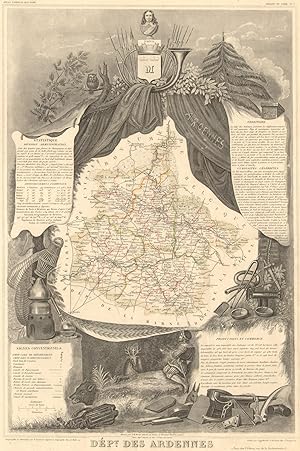
Add to basketCondition: Good. D�partement des ARDENNES. Decorative antique map/carte by Victor LEVASSEUR 1852. Antique steel engraved map with outline hand colour (color) applied at the time of printing. Wide margins; V Levasseur (c1852). 44.0 x 29.5cm, 17.25 x 11.5 inches. Condition: Good. The image shown may have been taken from a different example of this map than that which is offered for sale. The map you will receive is in good condition but there may be minor variations in the condition from that shown in the image. This map was coloured by hand at the time of publication, thus the colouration may vary slightly between different examples of the map; the colouring applied to the map you receive may differ slightly from that shown in the image. There is nothing printed on the reverse side, which is plain.
-
US$ 9.63
Convert currencyUS$ 13.35 shipping from United Kingdom to U.S.A.Quantity: 2 available
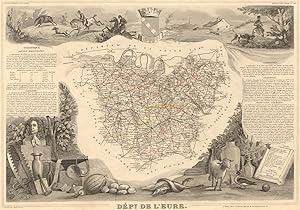
Add to basketCondition: Good. D�partement de l'EURE. Decorative antique map/carte by Victor LEVASSEUR 1852. Antique steel engraved map with outline hand colour (color) applied at the time of printing. Wide margins; V Levasseur (c1852). 29.5 x 42.5cm, 11.75 x 16.75 inches. Condition: Good. The image shown may have been taken from a different example of this map than that which is offered for sale. The map you will receive is in good condition but there may be minor variations in the condition from that shown in the image. This map was coloured by hand at the time of publication, thus the colouration may vary slightly between different examples of the map; the colouring applied to the map you receive may differ slightly from that shown in the image. There is nothing printed on the reverse side, which is plain.
-
US$ 10.32
Convert currencyUS$ 13.35 shipping from United Kingdom to U.S.A.Quantity: 6 available
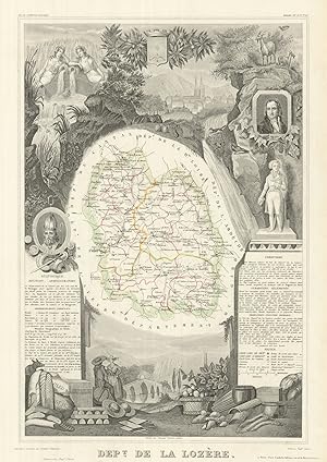
Add to basketCondition: Good. D�partement de la LOZ�RE. Decorative antique map/carte by Victor LEVASSEUR 1856. Antique steel engraved map with outline hand colour (color) applied at the time of printing. Wide margins; Victor Levasseur (1856). 43.0 x 29.0cm, 17 x 11.5 inches. Condition: Good. The image shown may have been taken from a different example of this map than that which is offered for sale. The map you will receive is in good condition but there may be minor variations in the condition from that shown in the image. This map was coloured by hand at the time of publication, thus the colouration may vary slightly between different examples of the map; the colouring applied to the map you receive may differ slightly from that shown in the image. There is nothing printed on the reverse side, which is plain.
-

US$ 10.32
Convert currencyUS$ 13.35 shipping from United Kingdom to U.S.A.Quantity: 5 available
Add to basketCondition: Good. D�partement du CHER. Decorative antique map/carte by Victor LEVASSEUR 1856. Antique steel engraved map with outline hand colour (color) applied at the time of printing. Wide margins; Victor Levasseur (1856). 43.5 x 28.5cm, 17 x 11.25 inches. Condition: Good. The image shown may have been taken from a different example of this map than that which is offered for sale. The map you will receive is in good condition but there may be minor variations in the condition from that shown in the image. This map was coloured by hand at the time of publication, thus the colouration may vary slightly between different examples of the map; the colouring applied to the map you receive may differ slightly from that shown in the image. There is nothing printed on the reverse side, which is plain.
-
US$ 10.32
Convert currencyUS$ 13.35 shipping from United Kingdom to U.S.A.Quantity: 2 available
Add to basketCondition: Good. D�partement de SEINE-ET-MARNE. Decorative antique map/carte. LEVASSEUR 1856. Antique steel engraved map with outline hand colour (color) applied at the time of printing. Wide margins; Victor Levasseur (1856). 46.5 x 28.0cm, 18.25 x 11 inches. Condition: Good. The image shown may have been taken from a different example of this map than that which is offered for sale. The map you will receive is in good condition but there may be minor variations in the condition from that shown in the image. This map was coloured by hand at the time of publication, thus the colouration may vary slightly between different examples of the map; the colouring applied to the map you receive may differ slightly from that shown in the image. There is nothing printed on the reverse side, which is plain.
-

US$ 10.32
Convert currencyUS$ 13.35 shipping from United Kingdom to U.S.A.Quantity: 6 available
Add to basketCondition: Good. D�partement de l'ARD�CHE. Decorative antique map/carte by Victor LEVASSEUR 1856. Antique steel engraved map with outline hand colour (color) applied at the time of printing. Wide margins; Victor Levasseur (1856). 42.0 x 28.0cm, 16.5 x 11 inches. Condition: Good. The image shown may have been taken from a different example of this map than that which is offered for sale. The map you will receive is in good condition but there may be minor variations in the condition from that shown in the image. This map was coloured by hand at the time of publication, thus the colouration may vary slightly between different examples of the map; the colouring applied to the map you receive may differ slightly from that shown in the image. There is nothing printed on the reverse side, which is plain.
-
US$ 10.32
Convert currencyUS$ 13.35 shipping from United Kingdom to U.S.A.Quantity: 2 available
Add to basketCondition: Good. D�partement de l'AISNE. Decorative antique map/carte by Victor LEVASSEUR 1856. Antique steel engraved map with outline hand colour (color) applied at the time of printing. Wide margins; Victor Levasseur (1856). 43.5 x 29.0cm, 17 x 11.25 inches. Condition: Good. The image shown may have been taken from a different example of this map than that which is offered for sale. The map you will receive is in good condition but there may be minor variations in the condition from that shown in the image. This map was coloured by hand at the time of publication, thus the colouration may vary slightly between different examples of the map; the colouring applied to the map you receive may differ slightly from that shown in the image. There is nothing printed on the reverse side, which is plain.
-
US$ 10.32
Convert currencyUS$ 13.35 shipping from United Kingdom to U.S.A.Quantity: 2 available
Add to basketCondition: Good. D�partement de l'AIN. Decorative antique map/carte by Victor LEVASSEUR 1856. Antique steel engraved map with outline hand colour (color) applied at the time of printing. Wide margins; Victor Levasseur (1856). 29.5 x 42.0cm, 11.75 x 16.5 inches. Condition: Good. The image shown may have been taken from a different example of this map than that which is offered for sale. The map you will receive is in good condition but there may be minor variations in the condition from that shown in the image. This map was coloured by hand at the time of publication, thus the colouration may vary slightly between different examples of the map; the colouring applied to the map you receive may differ slightly from that shown in the image. There is nothing printed on the reverse side, which is plain.
-
US$ 11.00
Convert currencyUS$ 13.35 shipping from United Kingdom to U.S.A.Quantity: 1 available
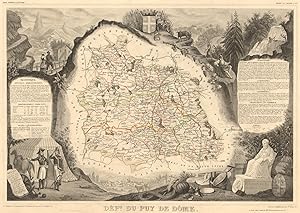
Add to basketCondition: Good. D�partement du PUY-DE-D�ME. Decorative antique map/carte. LEVASSEUR 1852. Antique steel engraved map with outline hand colour (color) applied at the time of printing. Wide margins; V Levasseur (c1852). 30.5 x 43.0cm, 12 x 17 inches. Condition: Good. The image shown may have been taken from a different example of this map than that which is offered for sale. The map you will receive is in good condition but there may be minor variations in the condition from that shown in the image. This map was coloured by hand at the time of publication, thus the colouration may vary slightly between different examples of the map; the colouring applied to the map you receive may differ slightly from that shown in the image. There is nothing printed on the reverse side, which is plain.
-
US$ 11.70
Convert currencyUS$ 13.35 shipping from United Kingdom to U.S.A.Quantity: 4 available
Add to basketCondition: Good. D�partement de l'OISE. Decorative antique map/carte by Victor LEVASSEUR 1856. Antique steel engraved map with outline hand colour (color) applied at the time of printing. Wide margins; Victor Levasseur (1856). 29.5 x 42.0cm, 11.5 x 16.5 inches. Condition: Good. The image shown may have been taken from a different example of this map than that which is offered for sale. The map you will receive is in good condition but there may be minor variations in the condition from that shown in the image. This map was coloured by hand at the time of publication, thus the colouration may vary slightly between different examples of the map; the colouring applied to the map you receive may differ slightly from that shown in the image. There is nothing printed on the reverse side, which is plain.
-
US$ 11.70
Convert currencyUS$ 13.35 shipping from United Kingdom to U.S.A.Quantity: 5 available
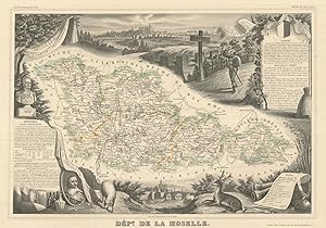
Add to basketCondition: Good. D�partement de la MOSELLE. Decorative antique map/carte. Victor LEVASSEUR 1856. Antique steel engraved map with outline hand colour (color) applied at the time of printing. Wide margins; Victor Levasseur (1856). 30.5 x 42.0cm, 12 x 16.5 inches. Condition: Good. The image shown may have been taken from a different example of this map than that which is offered for sale. The map you will receive is in good condition but there may be minor variations in the condition from that shown in the image. This map was coloured by hand at the time of publication, thus the colouration may vary slightly between different examples of the map; the colouring applied to the map you receive may differ slightly from that shown in the image. There is nothing printed on the reverse side, which is plain.
-

US$ 13.07
Convert currencyUS$ 13.35 shipping from United Kingdom to U.S.A.Quantity: 5 available
Add to basketCondition: Good. D�partement de la HAUTE-SA�NE. Decorative antique map/carte. LEVASSEUR 1856. Antique steel engraved map with outline hand colour (color) applied at the time of printing. Wide margins; Victor Levasseur (1856). 30.5 x 42.5cm, 12 x 16.75 inches. Condition: Good. The image shown may have been taken from a different example of this map than that which is offered for sale. The map you will receive is in good condition but there may be minor variations in the condition from that shown in the image. This map was coloured by hand at the time of publication, thus the colouration may vary slightly between different examples of the map; the colouring applied to the map you receive may differ slightly from that shown in the image. There is nothing printed on the reverse side, which is plain.
-
US$ 13.07
Convert currencyUS$ 13.35 shipping from United Kingdom to U.S.A.Quantity: 5 available
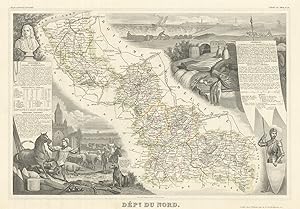
Add to basketCondition: Good. D�partement du NORD. Decorative antique map/carte by Victor LEVASSEUR 1856. Antique steel engraved map with outline hand colour (color) applied at the time of printing. Wide margins; Victor Levasseur (1856). 30.5 x 42.5cm, 12 x 16.75 inches. Condition: Good. The image shown may have been taken from a different example of this map than that which is offered for sale. The map you will receive is in good condition but there may be minor variations in the condition from that shown in the image. This map was coloured by hand at the time of publication, thus the colouration may vary slightly between different examples of the map; the colouring applied to the map you receive may differ slightly from that shown in the image. There is nothing printed on the reverse side, which is plain.
-
US$ 13.07
Convert currencyUS$ 13.35 shipping from United Kingdom to U.S.A.Quantity: 2 available
Add to basketCondition: Good. D�partement de la MEURTHE. Decorative antique map/carte. Victor LEVASSEUR 1856. Antique steel engraved map with outline hand colour (color) applied at the time of printing. Wide margins; Victor Levasseur (1856). 31.0 x 42.5cm, 12.25 x 16.75 inches. Condition: Good. The image shown may have been taken from a different example of this map than that which is offered for sale. The map you will receive is in good condition but there may be minor variations in the condition from that shown in the image. This map was coloured by hand at the time of publication, thus the colouration may vary slightly between different examples of the map; the colouring applied to the map you receive may differ slightly from that shown in the image. There is nothing printed on the reverse side, which is plain.
-
US$ 13.07
Convert currencyUS$ 13.35 shipping from United Kingdom to U.S.A.Quantity: 5 available
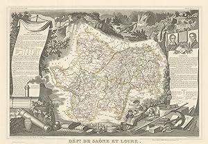
Add to basketCondition: Good. D�partement de SA�NE-ET-LOIRE. Decorative antique map/carte. LEVASSEUR 1856. Antique steel engraved map with outline hand colour (color) applied at the time of printing. Wide margins; Victor Levasseur (1856). 30.0 x 43.0cm, 11.75 x 16.75 inches. Condition: Good. The image shown may have been taken from a different example of this map than that which is offered for sale. The map you will receive is in good condition but there may be minor variations in the condition from that shown in the image. This map was coloured by hand at the time of publication, thus the colouration may vary slightly between different examples of the map; the colouring applied to the map you receive may differ slightly from that shown in the image. There is nothing printed on the reverse side, which is plain.
-
Atlas National Illustre Colonies Francaises en Amerique No. 92 (one page)
Published by V. Levasseur, Paris, 1840
disbound. Condition: Good -. Early Edition. folio, ca. 14.75" x 22.3 (ca. 37cm x 56cm). paper size with map with wonderful b&w illustrations around the central map - map areas colored in Outline. Paper is aged toned, and there are several very small chips lacking from around the edges and there are 5 closed tears around the edges ca 1 " long and ond ca. 3 " long - all not encroaching on the printed area. Fair to Good condition fair due to tears that might be repaired, Illistrated area very good. Colors fairly bright, but each map is very striking- a beautifully produced work. Text in French. There is light soiling around the edges along with the age darkening. No Publication date is noted, so 1840 is an estimate. Overall, contents are good perhaps a bit better and exterior is fair. Note: The page has not been folded, so it will, likely be shipped rolled up to protect it and to cost less, but it may cost more than an average books to send.