Beckwith Capt (4 results)

Reports of Explorations and Surveys to Ascertain the Most Practicable and Economical Route for a Railroad from the Mississippi River to the Pacific Ocean.Volume II
Beckwith, Lt. E.G. & Lander, F.W. & Pope, Capt. John & Parke, Lt. John G. & Emory, Lt. Col. W.H.
Language: English
Published by Beverley Tucker, Printer, Washington, D.C. 1855
- Hardcover
- First Edition
Seller: Springer Books, Sequim, WA, U.S.A.Springer Books
Contact seller4-star sellerCondition: Used - Fair
US$ 150.00
US$ 5.50 shippingShips within U.S.A.Quantity: 1 available
Hardcover. Condition: Fair. 1st Edition. Brown embossed boards. Contains: "Report of Explorations for a Route for the Pacific Railroad by Capt. J.W. Gunnison, Topographical Engineers Near the 38th and 39th Parallels of North Latitude from the Mouth of the Kansas River, Mo. to the Sevier Lake in the Great Basin." "Report of Explo…rations for a Route for the Pacific Railroad on the Line of the Forty-First Parallel of North Latitude" by Lt. E.G. Beckwith. "Synopsis of a Report of the Reconnaissance of a Railroad Route From Puget Sound via South Pass to the Mississippi River" by Fred W. Lander. "Report of Exploration of a Route for the Pacific Railroad near the Thirty-Second Parallel of North Latitude from the Red River to the Rio Grande" by Brevet Capt. John Pope. Many color and black and white plates. Some light foxing to several. Top 3/4 of spine detached and laid in. Binding itself is still tight. FAIR.
Published by Selmar Siebert's Engraving & Printing Establishment, Washington DC 1859
Seller: Antipodean Books, Maps & Prints, ABAA, Garrison, NY, U.S.A.Antipodean Books, Maps & Prints, ABAA
Contact seller3-star sellerFrom Explorations and Surveys made under the direction of Hon. Jefferson Davis, Secretary of War by Capt. E. G. Beckwith, 3d. Artillery, F. W. Egloffstein, Topographer for the Route, 1855. Lithograph map of the rivers and towns between 119°30 and 123°00 west longitude and 39° and 42° degrees north latitude, showing Pyramid Lake…in the east, the Klamath River in the west, and the Sacramento River at roughly the center. From the series of maps from surveys authorized by Congress in 1853 to find potential rail routes between the Mississippi River and the Pacific Ocean. Slightly toned at folds, short slit at center fold, very good. References: Wheat, C.I. (TM) 825.

Published by Selmar Siebert's Engraving & Printing Establishment, Washington DC 1859
Seller: Antipodean Books, Maps & Prints, ABAA, Garrison, NY, U.S.A.Antipodean Books, Maps & Prints, ABAA
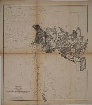
Contact seller3-star sellerFrom Explorations and Surveys made under the direction of Hon. Jefferson Davis, Secretary of War by Capt. E. G. Beckwith, 3d. Artillery, F. W. Egloffstein, Topographer for the Route, 1855. Lithograph map of the rivers and towns between 112° and 115°30 west longitude and 39° and 42° degrees north latitude, showing the Great Salt…Lake and Great Salt Lake City; to the south, along the Sevier River, is the place where a previous survey leader, Capt. Gunnison, was "killed by Indians". From the series of maps from surveys authorized by Congress in 1853 to find potential rail routes between the Mississippi River and the Pacific Ocean. Slightly toned at folds, sort slit at center fold, very good. References: Wheat, C.I. (TM) 823.
Published by United States War Department., Washington DC, United States 1855
- Map
Seller: Alexandre Antique Prints, Maps & Books, Toronto, ON, CanadaAlexandre Antique Prints, Maps & Books
Contact seller4-star sellerCondition: Used
US$ 375.00
US$ 6.00 shippingShips from Canada to U.S.A.Quantity: 1 available
A survey map of the Great Salt Lake towards the Humboldt Mountains, a path clearly laid out for the proposed railway route. The map covers present-day Utah and Nevada., Size : 528x463 (mm), 20.79x18.23 (Inches), Hand Colored Very Good, backed on acid free tissue paper for long term preservation.

