Order Total (1 Item Items):
Shipping Destination:

Blaeu G (12 results)
Author:
blaeu g
Refine with Advanced Search
Skip to main search results
Search filters
Product Type
- All Product Types
- Books (9)
- Magazines & Periodicals (No further results match this refinement)
- Comics (No further results match this refinement)
- Sheet Music (No further results match this refinement)
- Art, Prints & Posters (No further results match this refinement)
- Photographs (No further results match this refinement)
- Maps (3)
- Manuscripts & Paper Collectibles (No further results match this refinement)
Condition Learn more
- New (No further results match this refinement)
- As New, Fine or Near Fine (No further results match this refinement)
- Very Good or Good (5)
- Fair or Poor (No further results match this refinement)
- As Described (7)
Binding
- All Bindings
- Hardcover (2)
- Softcover (No further results match this refinement)
Collectible Attributes
- First Edition (1)
- Signed (No further results match this refinement)
- Dust Jacket (No further results match this refinement)
- Seller-Supplied Images (8)
- Not Print on Demand (12)
Language (1)
Free Shipping
- Free Shipping to U.S.A. (No further results match this refinement)
Seller Location
Seller Rating
-

Deutschland vor drei Jahrhunderten. Seine St�dte, Fl�sse u. W�lder betrachtet. M. e. nachw. v. C. Broekema.
Published by (G�tersloh) Bertelsmann (), 1971
Seller: Zentralantiquariat Leipzig GmbH, Leipzig, Germany
Seller rating 5 out of 5 stars

4�. M. zahlr. Ktn u. Abb. 300 S. OPp. m. OPp.-Schuber. Sprache: Deutsch.
-

Theatrum orbis terrarum, sive atlas novus tertia pars cum appendice.
Published by Dalmine, Milano, 1958
Seller: Studio Bibliografico Benacense, Riva del garda, TN, Italy
Seller rating 5 out of 5 stars
hardcover. Condition: Good. In-folio (cm. 50). Cartella contenente frontespizio, pp. (2) + 20 tavole a doppia pagina a colori raffiguranti le varie parti d'Italia. Entro custodia edit. in cart. rigido con dorso in pelle e titoli in oro. Ottima conservazione. Tiratura limitata di 1000 esemplari numerati. Book.
-
Gallaecia Regnum, descripta a F. Fer. Ojea Ord. Praed. et postmodum multis in locis emendata et aucta.
Published by Blaeu c. 1635, Amsterdam, 1635
Seller: Alexandre Antique Prints, Maps & Books, Toronto, ON, Canada
Seller rating 4 out of 5 stars

Map
Condition: Very Good; Two winged putti hold up a crown and shield in the upper left corner, and in their free hand hold a cloth with musical notation written upon it. The scale and legend are near the upper right corner, and a sea god carries the title cartouche within a sea shell. Several tall ships decorate the sea around Galicia, as well as two compass roses and a sea monster., Size : 382x503 (mm), 15.04x19.80 (Inches), Original Outline Coloring.
-
![Seller image for [Portfolio]: Antique Maps of the World in Color for sale by Between the Covers-Rare Books, Inc. ABAA](https://pictures.abebooks.com/inventory/md/md31614799540.jpg)
[Portfolio]: Antique Maps of the World in Color
Published by Sterling Publishing House, Co., Inc, New York, 1960
Seller: Between the Covers-Rare Books, Inc. ABAA, Gloucester City, NJ, U.S.A.
Association Member: ABAA ESA ILAB IOBA
Seller rating 5 out of 5 stars
First Edition
Unbound. Condition: Very Good. Portfolio. Color facsimiles of 36 historical maps. Each map measures approximately 12" x 9", printed on 17" x 11�" paper with descriptive text in the left margin. Housed with a title page sheet and unprinted top sheet in a four-fold chemise. Unprinted topsheet sunned at the edges, first two leaves with some very light toning and a couple of tiny corner creases; the maps are otherwise bright and fine. The chemise is good only with toning, wear, and soil, and a 1" creased tear on the cover panel. A nice production, and the chemise has done its job, keeping the maps bright and fresh.
-
Kein Einband. Condition: Gut. 38,2 x 50 cm gefaltete Landkarte, mit Mittelfalz, Papier altersbedingt etwas gebr�unt, sonst GUTES EXEMPLAR---Mit lateinischem R�ckseitentext. Blatt: 44 x 55,2 cm F�r Ihre Zufriedenheit versenden wir mit DHL und ausschlie�lich mit Trackingcode f�r eine sichere Sendungsverfolgung! Weitere Angebote unter antiquariat-kastanienhof , 1 Seiten. nein.
-
Territorio perugino
Published by 1660 ca., 1660
Seller: TABERNA LIBRARIA - ALAI - ILAB, Pistoia, PT, Italy
Seller rating 5 out of 5 stars
Carta tratta dall'atlante di Guglielmo Blaeu (circa 1660) impreziosita da vivace coloritura d'epoca, piu accentuata ai cartigli che contengono il tit. e la scala delle miglia. Ottima conservaz., fresca e nitida impressione.
-
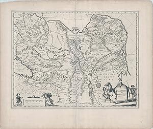
Tartaria sive Magni Chami Imperium
Published by Amsterdam, 1638
Seller: Antipodean Books, Maps & Prints, ABAA, Garrison, NY, U.S.A.
Association Member: ABAA ANZAAB ESA ILAB
Seller rating 4 out of 5 stars
Map. Condition: Very good overall. Blaeu's map of China, Tartary and Central Asia, from Mongolia to the Caspian Sea and the Volga River, and to Tibet and the Upper Ganges River. The map illustrates how mountainous the region is, along with several large lakes. The Great Wall of China is shown in great detail, separating China from the rest of north-central Europe. The tip of Korea is shown as an unnamed peninsula. The Great Wall of China is a distinctive feature, with a description that it was meant to deter Tartars invading. The map scale is decorated by a turbaned man and a cherub. The cartouche on the right has a man leading a camel with a child riding it. Black & white. Title surrounded by cartouche. 19 1/2 x 15 with wide margins.
-
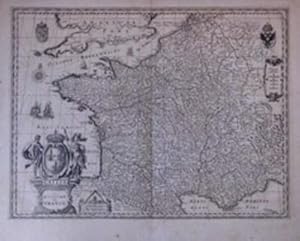
Gallia le Royaume de France
Published by Amsterdam, 1635
Seller: Antipodean Books, Maps & Prints, ABAA, Garrison, NY, U.S.A.
Association Member: ABAA ANZAAB ESA ILAB
Seller rating 4 out of 5 stars
Black & white. Title surrounded by cartouche. Few worm holes restored. 19 1/2 x 15 with wide margins. France.
-
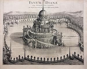
Fanum Dianae; Cum Circumambiente Naumachia, Ad Regiae Venationis Nemora, Moles omnino visenda
Published by Joannes Blaeu, Amsterdam, 1680
Seller: Argosy Book Store, ABAA, ILAB, New York, NY, U.S.A.
Seller rating 5 out of 5 stars
unbound. Print. Uncolored engraving. Image measures 19.25 x 24 inches, sheet measure 20.5 x 26 inches. Shows some light foxing, as well as a repaired ~2 inch tear at left margin. Top edge trimmed to neat line. In very good condition. Outstanding view of a baroque pleasure palaces and garden from 'Theatrum Statuum Regiae Sabaudiae'. The series features maps, topographic views of Turin and cities and towns of Piedmont and Savoy. One of the most prolific Dutch mapmakers of his time, Willem Blaeu (1571-1638) started one of the most famous map publishing firms of the 17th century. It was at this time that the Dutch controlled the map trade, and their ornate and beautiful maps had immense popularity. Blaeu and his family worked out of Amsterdam and was instrumental in driving this dominance in his lifetime, and this legacy was continued by his sons. "Theatrum Statuum Regiae Sabaudiae" was published by his son Johannes (c. 1599-1673), who took over the business upon his father's death.
-
Navarra Regnum.
Published by G. Blaeu c. 1620, Amsterdam, 1620
Seller: Alexandre Antique Prints, Maps & Books, Toronto, ON, Canada
Seller rating 4 out of 5 stars
Map
Condition: Very Good; Title cartouche in lower left corner features a Navarran army camp, while various regional shields decorate the borders of Navarre., Size : 418x503 (mm), 16.46x19.80 (Inches), Original Outline Coloring.
-
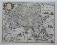
Asia noviter delineata
Published by Amsterdam, 1645
Seller: Alexandre Antique Prints, Maps & Books, Toronto, ON, Canada
Seller rating 4 out of 5 stars
Map
This map is the same famous map of Asia by Blaeu but is printed without the ornamental boarder cartouches. "Korea is drawn as an island marked Corea Ins. There is no hint at all of Australia to the south of the East Indies, but there is a strong suggestion of a sea passage from Europe via a Northeast passage through the Strait of Anian between Norteastern Asia and America.\\\"The map highly decorated with animals, sea monsters and sailing ships. A large island labeled Ceiram probably represents the western part of New Guinea. In the interior, the Caspian Sea is oriented on an east-west axis as opposed to the correct north-south orientation., Size : 370x465 (mm), 14.5x18.25 (Inches), Hand Colored in Outline, 0 Margins shaved closely and laid on acid free paper for long term preservation, otherwise a very good copy.
-