Celestial Chart (51 results)

Language: German
- Map
Seller: Antiquariat Clemens Paulusch GmbH, Berlin, , GermanyAntiquariat Clemens Paulusch GmbH
Contact seller5-star sellerCondition: Used
US$ 23.84
US$ 31.14 shippingShips from Germany to U.S.A.Quantity: 1 available
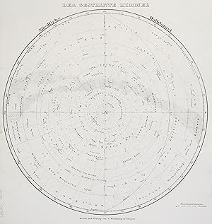
um 1835, 15 x 10,5 (H).

Language: German
- Map
Seller: Antiquariat Clemens Paulusch GmbH, Berlin, , GermanyAntiquariat Clemens Paulusch GmbH
Contact seller5-star sellerCondition: Used
US$ 35.77
US$ 31.14 shippingShips from Germany to U.S.A.Quantity: 1 available
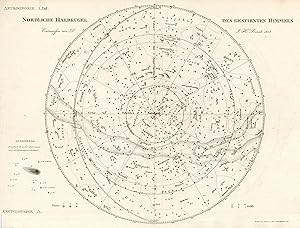
nach 1856, 20 x 26 Zeigt die wichtigsten Sternbilder um die Milchstrasse. Daneben "Einige Figuren zur mathematischen Geographie.".

Language: German
- Map
Seller: Antiquariat Clemens Paulusch GmbH, Berlin, , GermanyAntiquariat Clemens Paulusch GmbH
Contact seller5-star sellerCondition: Used
US$ 47.69
US$ 31.14 shippingShips from Germany to U.S.A.Quantity: 1 available
dat. 1846, 29,4 x 35,3 Der südl. Sternenhimmel mit den Sternbildern.

Language: German
- Map
Seller: Antiquariat Clemens Paulusch GmbH, Berlin, , GermanyAntiquariat Clemens Paulusch GmbH
Contact seller5-star sellerCondition: Used
US$ 53.65
US$ 31.14 shippingShips from Germany to U.S.A.Quantity: 1 available
Deutsche A 1719, 15 x 10,5 (H) Dargestellt sind 5 Tierkreiszeichen, darunter Schwan, Andromeda usw.

Language: German
- Map
Seller: Antiquariat Clemens Paulusch GmbH, Berlin, , GermanyAntiquariat Clemens Paulusch GmbH
Contact seller5-star sellerCondition: Used
US$ 53.65
US$ 31.14 shippingShips from Germany to U.S.A.Quantity: 1 available
Deutsche A 1719, 15 x 10,5 (H) Dargestellt sind 3 Tierkreiszeichen, darunter großer und kleiner Bär, Fisch.

Language: German
- Map
Seller: Antiquariat Clemens Paulusch GmbH, Berlin, , GermanyAntiquariat Clemens Paulusch GmbH
Contact seller5-star sellerCondition: Used
US$ 59.61
US$ 31.14 shippingShips from Germany to U.S.A.Quantity: 1 available
altkol., 1873, 20 x 39 Der nördl. u. südl. Sternenhimmel in 2 Hemisphären.

Language: German
- Map
Seller: Antiquariat Clemens Paulusch GmbH, Berlin, , GermanyAntiquariat Clemens Paulusch GmbH
Contact seller5-star sellerCondition: Used
US$ 59.61
US$ 31.14 shippingShips from Germany to U.S.A.Quantity: 1 available
um 1840, 20 x 24,4 Zeigt den nördl. Sternenhimmel m. d. Sternbildern.

Language: German
- Map
Seller: Antiquariat Clemens Paulusch GmbH, Berlin, , GermanyAntiquariat Clemens Paulusch GmbH
Contact seller5-star sellerCondition: Used
US$ 59.61
US$ 31.14 shippingShips from Germany to U.S.A.Quantity: 1 available
Deutsche A 1719, 14 x 10 (H) Zeigt den südl. Sternenhimmel, darunter Erklärungen zu den Sternbildern in franz. Sprache.
Language: German
- Map
Seller: Antiquariat Clemens Paulusch GmbH, Berlin, , GermanyAntiquariat Clemens Paulusch GmbH
Contact seller5-star sellerCondition: Used
US$ 59.61
US$ 31.14 shippingShips from Germany to U.S.A.Quantity: 1 available
1854, 36 x 34 (H) Zeigt die nördl. Sternenhimmel.

Language: German
- Map
Seller: Antiquariat Clemens Paulusch GmbH, Berlin, , GermanyAntiquariat Clemens Paulusch GmbH
Contact seller5-star sellerCondition: Used
US$ 71.53
US$ 31.14 shippingShips from Germany to U.S.A.Quantity: 1 available
Deutsche A 1719, 14,5 x 10 (H) Zeigt den südl. Sternenhimmel.

Language: German
- Map
Seller: Antiquariat Clemens Paulusch GmbH, Berlin, , GermanyAntiquariat Clemens Paulusch GmbH
Contact seller5-star sellerCondition: Used
US$ 89.42
US$ 31.14 shippingShips from Germany to U.S.A.Quantity: 1 available
dat. 1718, 25,5 ( Durchmesser ).
Language: German
- Map
Seller: Antiquariat Clemens Paulusch GmbH, Berlin, , GermanyAntiquariat Clemens Paulusch GmbH
Contact seller5-star sellerCondition: Used
US$ 89.42
US$ 31.14 shippingShips from Germany to U.S.A.Quantity: 1 available
dat. 1718, 25,5 ( Durchmesser ).
 More images
- Map
Seller: Geographicus Rare Antique Maps, Brooklyn, NY, U.S.A.Geographicus Rare Antique Maps
Contact seller4-star sellerGood. Closed edge tears not entering printed image professionally repaired on verso. Foxing. Size 10.5 x 12.5 Inches. A hand-colored example of Julius Schiller's 1627 depiction of the Lupus Constellation, represented by the Biblical figure Jacob. It appeared in Schiller's rare star atlas Coelum Stellatum Christianum , which aime…d but failed to have fellow astronomers exchange the classical zodiac and Greco-Roman figures for Christian icons. A Closer Look The stars of the Lupus Constellation are represented by the patriarch Jacob, the forefather of the Israelites. The stars are numbered, corresponding to an index that would have appeared on the preceding page (due to the design and pagination of Schiller's atlas, most of the constellations are explained on the preceding page, with the verso of each plate explaining the following image; therefore, the verso here discusses the Ara constellation / Altaris Thymiamatis). Other constellations are similarly represented by Biblical imagery, including the just mentioned Ara (the Showbread Table, at the center towards the right), Centaurus (as Abraham and Isaac, at far left), and Scorpius (as Bartholomew the Apostle, at the top). Schiller's Coelum Stellatum Christianum The Coelum Stellatum Christianum is a star atlas published in 1627 by Julius Schiller (1580 - 1627), a German lawyer and astronomer, in collaboration with Johann Bayer (1572 - 1625), who had published his own highly influential star atlas in 1603, the Uranometria Omnium Asterismorum . Schiller, however, sought to replace the traditional Greco-Roman constellations with Christian figures. Zodiac signs were replaced by the Twelve Apostles; the Sun was replaced by Jesus Christ, the Moon by Mary, and so on, with a range of figures drawn from the Old and New Testaments. In astronomical terms, Schiller incorporated findings from Johannes Kepler's 1627 Tabulae Rudolphinae and other recent observations, thus improving upon Bayer's Uranometria . Although Schiller's work did not convince other astronomers to replace the terminology and imagery of the heavens, in retrospect, it constituted the best star atlas until nearly the end of the century (when it was bested by Hevelius' 1690 Firmamentum Sobiescianum sive Uranographia ). Publication History and Census This plate was prepared by Julius Schiller for his 1627 work Coelum Stellatum Christianum , published in Augsburg by Andreas Aperger. It is worth noting that Schiller simultaneously published a second atlas titled Coelum Stellatum Christianum Concavum , consisting of counter-proofs of the plates from the first atlas, including the stars but before the constellation figures had been added. This was done in part because Schiller rather atypically projected the stars and constellations as if on the surface of a globe viewed externally in the Coelum Stellatum Christianum , while the Concavum projected them as seen from the Earth, as Bayer and others had done. This plate is not independently cataloged in the holdings of any institution, and the entire Coelum Stellatum Christianum is quite rare. A complete census is difficult to establish given inconsistent cataloging and the complicating factor of the Concavum , but we can confirm that in North America, examples of the entire atlas are held by the Library of Congress, Stanford University, and the Linda Hall Library.

- Map
Seller: Geographicus Rare Antique Maps, Brooklyn, NY, U.S.A.Geographicus Rare Antique Maps
Contact seller4-star sellerVery good. Light discoloration around border. Text on verso. Size 10.5 x 12.25 Inches. A lovely hand-colored 1627 celestial chart of the Hydra constellation, reimagined as the River Jordan, with surrounding constellations similarly replaced by Biblical imagery. It appeared in Julius Schiller's rare 1627 star atlas Coelum Stellat…um Christianum , which aimed, but failed, to supplement classical zodiac Greco-Roman celestial nomenclature for Christian-themed naming conventions. A Closer Look The River Jordan (Hydra constellation) appears at the center and towards top-right, denoted by rocks, with coordinate lines drawn and stars labeled with letters and Latin numerals. Portions or the entirety of neighboring constellations can be seen as well, including Crater and Corvus (reimagined as the Ark of the Covenant), Argo Navis (Noah's Ark), and Centaurus (Abraham and Isaac). The verso includes tables and text explaining Schiller's Christian nomenclature for stars next to their more common classically derived names. However, due to the design and pagination of Schiller's atlas, most of the constellations are explained on the preceding page, with the verso of each plate explaining the following image. Therefore, the verso here discusses the Crater and Corvus constellations (Ark of the Covenant), while the corresponding text for the recto image of the River Jordan would have appeared on the preceding page. Schiller's 'Coelum Stellatum Christianum' The Coelum Stellatum Christianum is a star atlas published in 1627 by Julius Schiller (1580 - 1627), a German lawyer and astronomer, in collaboration with Johann Bayer (1572 - 1625), who had published his own highly influential star atlas in 1603, the Uranometria Omnium Asterismorum . Schiller, however, sought to replace the traditional Greco-Roman constellations with a Christian naming system. Schiller's Zodiac signs were replaced by the Twelve Apostles, the Sun was replaced by Jesus Christ, the Moon by Mary, and so on, with a range of figures drawn from the Old and New Testaments. In astronomical terms, Schiller incorporated findings from Johannes Kepler's 1627 Tabulae Rudolphinae and other recent observations, thus improving upon Bayer's Uranometria . Although Schiller's work did not succeed in introducing a new heavenly nomenclature, in retrospect, it constituted the best star atlas until nearly the end of the century (when it was bested by Hevelius' 1690 Firmamentum Sobiescianum sive Uranographia ). Publication History and Census This plate was prepared by Julius Schiller for his 1627 work Coelum stellatum Christianum , published in Augsburg by Andreas Aperger. It is worth noting that Schiller simultaneously published a second atlas titled Coelum stellatum Christianum Concavum , consisting of counter-proofs of the plates from the first atlas, including the stars but before the constellation figures had been added. This was done in part because Schiller rather atypically projected the stars and constellations as if on the surface of a globe viewed externally in the Coelum stellatum Christianum , while the Concavum projected them as seen from the Earth, as Bayer and others had done. This plate is not independently cataloged in the holdings of any institution, and the entire Coelum stellatum Christianum is quite rare. A complete census is difficult to establish given inconsistent cataloging and the complicating factor of the Concavum , but we can confirm that in North America, examples of the atlas are held by the Library of Congress, Stanford University, and Linda Hall Library.

Neue Himmelsbeschreibung oder sehr leichte Methode die Sternbilder durch die außere Gestalt der vornehmsten Sterne unter denselben kennen zu lernen.
1804 Walch Celestial Chart w/ Manuscript Record of Great Comet of 1811
- Map
Seller: Geographicus Rare Antique Maps, Brooklyn, NY, U.S.A.Geographicus Rare Antique Maps
Contact seller4-star sellerGood. Old mounting on thick paper for binding. Wear along original centerfold. Trimmed to border on left and right sides. Size 18.5 x 23 Inches. This is an 1804 celestial map, with extensive manuscript annotations, prepared by Johannes Walch. Aside from its aesthetic qualities, the chart is noteworthy for its manuscript annotati…ons recording the Great Comet of 1811. Overall, the chart captures the state of astronomical knowledge at the time, including the discovery of Uranus by astronomer William Herschel (1738-1822). A Closer Look The top part of the sheet contains a dual hemispheric depiction of the heavens, the 'midday' or northern hemisphere at left and the 'midnight' or southern hemisphere at right, with both hemispheres ringed by a border with the months of the year subdivided into sections. Constellations are labeled throughout in German or, in some cases, Latin, while the constellations' individual stars are labeled according to the Bayer system of classification. Stars, including nebula stars, are represented with symbols reflecting their size, as indicated in a small legend on the left. The hemispheres, particularly the right, contain significant manuscript annotations, including illustrations and dates of major comets, such as the Great Comet of 1811. Below the meeting point of the hemispheres are two quotes from poems, one by the ancient astronomer Marcus Manilius (c. 1st century CE) and the other by 18th-century naturalist Albrecht von Haller (1708 - 1777). The bottom portion of the sheet traces the seasonal deviation of the stars and also the recent (c. 1790s) movements of Mars, Jupiter, Saturn, and a body marked 'Herschel 1787.' This was perhaps one of the moons of Uranus (Oberon and Titania) discovered by German-British astronomer William Herschel that year, but more likely a reference to his earlier (1781) discovery of Uranus itself; the name of the new planet was not settled for decades and it was commonly referred to after its discoverer in these years. Herschel and his sister Caroline (1750-1848), who was his lifelong collaborator, pioneered many innovations in telescopy and astronomical spectroscopy that set off a period of improved astronomical observations. Publication History and Census This chart was prepared and published by Johannes Walch in Augsburg in 1804. Subsequent editions were published in 1820, 1826, 1833, and 1836, which, like the present edition, are quite scarce in institutional collections, especially outside of Germany. The only known institutional holding in North America is at Harvard University. References: OCLC 729688955.
 More images
[Bootes]. / Tabula. Quinta Bootes. [handwritten on verso]
1603 / c. 1640 Bayer Celestial Chart of the Boötes Constellation
- Map
Seller: Geographicus Rare Antique Maps, Brooklyn, NY, U.S.A.Geographicus Rare Antique Maps
Contact seller4-star sellerVery good. Manuscript writing on recto and verso. Tab attached to left margin. Size 11.25 x 15 Inches. A lovely c. 1640 example of Johannes Bayer's celestial chart of the zodiacal constellation Boötes (the 'herdsman' or 'ploughman'), published in his seminal Uranometria , one of the most important celestial atlases of the early…modern period. As the forerunner of all later celestial atlases, the significance and relevance of this work are emphasized by its continued publication throughout the mid-17th century. A Groundbreaking Atlas of the Heavens Bayer's Uranometria was built on the work of Tycho Brahe and Alessandro Piccolomini, but he added roughly a thousand additional stars. Bayer's breakthrough was, first, to fix all of these discovered stars to a reference grid (visible just inside the border) and, second, to provide a systematic format for their classification. Bayer's system - still in use - is known as the Bayer Designation. Bayer assigned Greek letters to each star of a given constellation in order of apparent size; thus, the brightest star of the Boötes constellation was classified as Alpha Boötis (also known by its ancient Greek name, Arcturus). Beta Boötis (also known by its Arabic-derived name Nekkar or Nakkar) appears at the top of Boötes' scythe, Gamma Boötis (also known as Ceginus, seemingly a late Medieval or Renaissance era mistranslation of the Arabic version of the ancient Greek 'Boötes' ??????) sits near Boötes' left shoulder, and so on. Handwritten notes record nearby stars in the tail of Ursa Major, and mention that Nu Boötis overlaps with the Hercules constellation. Publication History and Census This plate was engraved by Alexander Mair for inclusion in the 1603 Augsburg edition of Johann Bayer's Uranometria , published by Christoph Mang. The plates were acquired in the late 1630s by Johann Görlin the Elder, an Ulm bookseller, who republished Bayer's work several times beginning in the 1630s. The Ulm editions are distinguishable from the Augsburg editions by the absence of verso text on the plates; otherwise, they are unchanged. Some later editions (such as the 1655 edition in the Rumsey Map Collection) are printed on a single, unfolded sheet. This example is also distinctive for the crossed lines in the margin at the upper-left, which we have only seen in one other example, though the implications of this fact for dating the chart are unclear. The tag attached at left suggests that the charts may have been delivered to their original owner unbound. While the various editions of Uranometria are well represented in institutional collections, the separate plates are ill-cataloged and are fairly scarce to the market. References: Rumsey 12181.007 (1655 ed.).

[Auriga]. / Tabula Duodecima Auriga et Erichthonius [handwritten on verso].
1603 / c. 1640 Bayer Celestial Chart of the Auriga Constellation
- Map
Seller: Geographicus Rare Antique Maps, Brooklyn, NY, U.S.A.Geographicus Rare Antique Maps
Contact seller4-star sellerVery good. Manuscript writing on verso. Tab attached to left margin. Size 11 x 14.75 Inches. A charming c. 1640 example of Johannes Bayer's celestial chart of the zodiacal constellation Auriga ('the charioteer'), published in his seminal Uranometria , one of the most important celestial atlases of the early modern period. As the… forerunner of all later celestial atlases, the significance and relevance of this work are emphasized by its continued publication throughout the mid-17th century. A Groundbreaking Atlas of the Heavens Bayer's Uranometria was built on the work of Tycho Brahe and Alessandro Piccolomini, but he added roughly a thousand additional stars. Bayer's breakthrough was, first, to fix all of these discovered stars to a reference grid (visible just inside the border) and, second, to provide a systematic format for their classification. Bayer's system - still in use - is known as the Bayer Designation. Bayer assigned Greek letters to each star of a given constellation in order of apparent size; thus, the brightest star of the Auriga constellation was classified as Alpha Aurigae (Capella, the sixth-brightest star in the night sky). Beta Aurigae (also known by its Arabic-derived name Menkalinan) appears near Auriga's left shoulder, Gamma Aurigae (considered by Bayer to be shared with the Taurus Constellation but now generally known only as Beta Tauri) sits at Auriga's left ankle, and so on. The river-like feature overlying the constellation is the Milky Way. The version contains extensive handwritten text on the verso, listing the largest stars in the constellation according to Bayer's system and describing the constellation in German. Publication History and Census A charming c. 1640 example of Johannes Bayer's celestial chart of the zodiacal constellation Auriga ('the charioteer'), published in his seminal Uranometria , one of the most important celestial atlases of the early modern period. As the forerunner of all later celestial atlases, the significance and relevance of this work are emphasized by its continued publication throughout the mid-17th century. References: Rumsey 12181.014 (1655 ed.). OCLC 435639611.
 More images
Contellatio XIX. [Mitrae Pontificalis S. Petri].
1627 Schiller Celestial Chart of the Triangulum Constellation
- Map
Seller: Geographicus Rare Antique Maps, Brooklyn, NY, U.S.A.Geographicus Rare Antique Maps
Contact seller4-star sellerVery good. Minor discoloration lower margin. Size 11.25 x 13 Inches. A beautiful 1627 celestial chart of the Triangulum constellation, reimagined as an angel holding the Papal tiara, with surrounding constellations similarly replaced by Biblical imagery. It appeared in Julius Schiller's rare 1627 star atlas Coelum Stellatum Chri…stianum , which aimed, but failed, to have fellow astronomers exchange the classical zodiac and Greco-Roman figures for Christian ones. A Closer Look The stars of the Triangulum constellation are represented as an angel holding the Papal tiara. Other nearby constellations are similarly represented with Biblical figures and references, such as St. Paul (Perseus) at top-right, the Holy Sepulcher (Andromeda) at top-left, and St. Peter (Aries), clutching the Keys of Heaven, at bottom. The verso includes tables and text explaining Schiller's Christian nomenclature for stars next to their more common classically derived names. However, due to the design and pagination of Schiller's atlas, most of the constellations are explained on the preceding page, with the verso of each plate explaining the following image. Therefore, the verso here discusses the Aries constellation (Sancti Petri Principus Apostolorum), while the corresponding text for the recto image of the Triangulum constellation would have appeared on the preceding page. Schiller's 'Coelum Stellatum Christianum' The Coelum Stellatum Christianum is a star atlas published in 1627 by Julius Schiller (1580 - 1627), a German lawyer and astronomer, in collaboration with Johann Bayer (1572 - 1625), who had published his own highly influential star atlas in 1603, the Uranometria Omnium Asterismorum . Schiller, however, sought to replace the traditional Greco-Roman constellations with Christian figures. Zodiac signs were replaced by the Twelve Apostles, the Sun was replaced by Jesus Christ, the Moon by Mary, and so on, with a range of figures drawn from the Old and New Testaments. In astronomical terms, Schiller incorporated findings from Johannes Kepler's 1627 Tabulae Rudolphinae and other recent observations, thus improving upon Bayer's Uranometria . Although Schiller's work did not convince other astronomers to replace the terminology and imagery of the heavens, in retrospect, it constituted the best star atlas until nearly the end of the century (when it was bested by Hevelius' 1690 Firmamentum Sobiescianum sive Uranographia ). Publication History and Census This plate was prepared by Julius Schiller for his 1627 work Coelum Stellatum Christianum , published in Augsburg by Andreas Aperger. It is worth noting that Schiller simultaneously published a second atlas titled Coelum Stellatum Christianum Concavum , consisting of counter-proofs of the plates from the first atlas, including the stars but before the constellation figures had been added. This was done in part because Schiller rather atypically projected the stars and constellations as if on the surface of a globe viewed externally in the Coelum Stellatum Christianum , while the Concavum projected them as seen from the Earth, as Bayer and others had done. This plate is not independently cataloged in the holdings of any institution, and the entire Coelum Stellatum Christianum is quite rare. A complete census is difficult to establish given inconsistent cataloging and the complicating factor of the Concavum , but we can confirm that in North America examples of the entire atlas are held by the Library of Congress, Stanford University, and Linda Hall Library.

- Map
Seller: Geographicus Rare Antique Maps, Brooklyn, NY, U.S.A.Geographicus Rare Antique Maps
Contact seller4-star sellerGood. Light soiling. Notable creasing along centerfold, especially at bottom. Spots of discoloration and surface abrasion on and near centerfold. Size 16.75 x 22.5 Inches. An intricately engraved 1687 double hemisphere celestial chart prepared by Francesco Brunacci for inclusion in Giacomo Giovanni Rossi's atlas Mercurio Geograf…ico, overo Guida Geografica in tutte le parti del Mondo , one of the most beautiful Italian atlases of the 17th century. A Closer Look The night sky is presented in two hemispheres on a polar stereographic projection, centered on the ecliptic poles, which differ slightly from the Arctic and Antarctic poles noted nearby. Stars are classified into six sizes (noted on a legend at bottom towards left). The mythological figures associated with the major constellations are illustrated, superimposed over the stars, and labeled. Longitude lines marking out degrees at intervals of 30 crisscross the hemispheres, as do curved lines representing the paths of tropics and equinoxes. Beyond the hemispheres, the sun (at center-top), moon (at center-bottom), and other planets (in the corners) are depicted, corresponding to a legend at bottom. The presentation of the sun and moon is especially interesting, given the inclusion of sunspots on the former and a profusion of craters and mare on the latter. The lower part of the sheet includes a 'Description of the Celestial Globe by Francesco Brunacci,' explaining the representation of the night sky above (inspired by Johann Bayer's 1603 star atlas Uranometria ), discussing the number of stars and other celestial features included, their distances from Earth, and similar details. Publication History and Census This sheet was prepared by Francesco Brunacci and engraved by Vincenzo Mariotti in 1687 for Giacomo Giovanni Rossi's atlas Mercurio Geografico, overo Guida Geografica in tutte le parti del Mondo . It served as the first chart or map in the atlas, following the title page. It is listed among the holdings of the Bibliothèque nationale de France, the Biblioteca Nacional de España, the Sächsische Landesbibliothek - Staats- und Universitätsbibliothek, the Bayerische Staatsbibliothek, the National Library of Australia, and the National Library of New Zealand in the OCLC. References: OCLC 949815644, 1410545555, 312894217, 243523933.

- Map
Seller: Geographicus Rare Antique Maps, Brooklyn, NY, U.S.A.Geographicus Rare Antique Maps
Contact seller4-star sellerVery good. 2-inch tear on top-side border professionally repaired. Size 11 x 15 Inches. This is a beautiful Johann Bayer's celestial chart of the zodiacal constellation Aquarius. It was engraved for Bayer's seminal 1603 celestial atlas, Uranometria: omnium asterismorum content schemata, nova methodo delineata, aereis laminis exp…ressa . As the forerunner of all later celestial atlases, the importance and relevance of this work are emphasized by its continued publication throughout the mid-17th century. A Groundbreaking Atlas of the Heavens Bayer's Uranometria was built on the work of Tycho Brahe and Alessandro Piccolomini, but he added roughly a thousand additional stars. Bayer's breakthrough was, first, to fix all of these discovered stars to a reference grid (visible just inside the border) and, second, to provide a systematic format for their classification. Bayer's system - still in use - is known as the Bayer Designation. Bayer assigned Greek letters to each star of a given constellation in order of apparent size; thus, the brightest star of the Aquarius constellation was classified as Alpha Aquarii (also known by its Arabic-derived name, Sadalmelik). Beta Aquarii (Sadalsuud) appears next to Aquarius' right shoulder (the Greek letter obscured by hand-painting), Gamma Aquarii (Sadachbia) sits near Aquarius' left forearm and the handle holding his water jug, and so on. Publication History and Census This plate was engraved by Alexander Mair for inclusion in the 1603 Augsburg edition of Johann Bayer's Uranometria . The plates were acquired in the late 1630s by Johann Görlin the Elder, an Ulm bookseller who republished Bayer's work in two separate volumes - first in 1639, and thereafter in apparently identical editions in 1648, 1655, and 1661 - the present map is from one of the Ulm editions. The Ulm editions are distinguishable from the Augsburg editions by the absence of verso text on the plates; otherwise, they are unchanged. The various editions of Uranometria are well represented in institutional collections. The separate plates are ill-cataloged, with only one 1603 example of this plate identified in OCLC at the National Library of Australia. References: OCLC 435639646 (1603 printing).

- Map
Seller: Geographicus Rare Antique Maps, Brooklyn, NY, U.S.A.Geographicus Rare Antique Maps
Contact seller4-star sellerVery good. Light wear along original centerfold. Size 11.75 x 14.5 Inches. This is a 1690 Johannes Hevelius celestial chart or star map of the Virgo constellation from his influential work Firmamentum Sobiescianum, sive Uranographia . Virgo dominates the sheet, which also includes adjacent Bootes, Mons Menalus, Libra, Scorpius,…Centaurus, Hydra, Corvus, Crader, and Leo. Publication History and Census This map was created by Johannes Hevelius and published in 1690 in his Firmamentum Sobiescianum, sive Uranographia by his widow Elisabeth Hevelius.

Ephemerides Motuum Coelestium Geometricae.
1710 Homann / Doppelmayr Celestial Chart Explaining Planetary Motion
- First Edition
- Map
Seller: Geographicus Rare Antique Maps, Brooklyn, NY, U.S.A.Geographicus Rare Antique Maps
Contact seller4-star seller1st Edition. Very good. Old mounting on thick paper for binding; attractive original hand color. Marginal soiling to lower corners; else excellent with no mends or tears. Size 19 x 22.5 Inches. This fascinating 1710 celestial chart is a collaboration between mathematician and astronomer Johan Gabriel Doppelmayr and Johann Baptis…t Homann. It was produced to explain Copernicus' theories of planetary motion and apparent retrograde motion using data from observations in 1708 and 1709. Ingeniously Composed The ingeniously composed chart is embellished with an allegorical depiction of the discovered planets: Earth is shown as a regal, winged Gaia with a cornucopia; the other planets are putti wearing the classical garb associated with them - Mercury with his winged sandals and caduceus; Venus with a torch (alluding the brightness of the morning star); Mars with sword, shield, and helm; lightning-spitting Jupiter, and Saturn with his scythe and hourglass. Both these latter are attended by their orbiting moons. A Closer Look The central, circular diagram depicts a simplified Copernican solar system with the sun at center. The diagram's scale prevents the inclusion of Mercury and Venus, and so the first depicted orbit is that of Earth, beyond which are the concentric orbits of Mars, Jupiter, and Saturn. Each orbit is marked with the observed, monthly positions of their respective planets for the years 1708 and 1709, as well as their projected positions throughout the rest of their orbit around the sun (as late as 1757 for Saturn, an overestimation: Saturn's year is only 29.4 of our own.) The purpose of the diagram is to explain the phenomenon of retrograde motion. From the perspective of an observer on Earth, the planets appear to move in a predictable manner - only to apparently reverse direction for a span of months before resuming their journey across the sky. This phenomenon is caused by the fact that while the observed planets move, Earth itself remains in motion, overtaking the slower outer planets (or being overtaken by the inner planets) and creating the illusion of the other planet's apparent reversal. Thus, in addition to the central chart of the solar system, there are diagrams showing the 1708-9 observations of the apparent retrograde motion of each of the planets, keyed to their actual positions on the diagram. Publication History and Census This is the first edition of this celestial, engraved for inclusion in the 1710 issue of Homann's Neuer Atlas . It remained in Homann and Homann Heirs atlases well into the 18th century. In its various editions, the map is represented in 18 institutional collections. References: OCLC 248598463. Rumsey 12499.044 (1716 state).

Language: German
- Map
Seller: Antiquariat Clemens Paulusch GmbH, Berlin, , GermanyAntiquariat Clemens Paulusch GmbH
Contact seller5-star sellerCondition: Used
US$ 154.99
US$ 31.14 shippingShips from Germany to U.S.A.Quantity: 1 available
1875, 49,6 cm. im Durchmesser farblich grundiert.

Language: German
- Map
Seller: Antiquariat Clemens Paulusch GmbH, Berlin, , GermanyAntiquariat Clemens Paulusch GmbH
Contact seller5-star sellerCondition: Used
US$ 178.84
US$ 31.14 shippingShips from Germany to U.S.A.Quantity: 1 available
kol., um 1800, 16 x 19,9 Hübsches Blatt aus dem 1erstmals 1768 (und dann mehrfach in verschiedenen Auflagen) erschienenen Werk "Anleitung zur Kenntnis des gestirnten Himmels". Zeigt die im Monat Oktober zu sehenden Sternenbilder. Minimal knitterig, aber sauber und farbfrisch erhalten.

Language: German
- Map
Seller: Antiquariat Clemens Paulusch GmbH, Berlin, , GermanyAntiquariat Clemens Paulusch GmbH
Contact seller5-star sellerCondition: Used
US$ 178.84
US$ 31.14 shippingShips from Germany to U.S.A.Quantity: 1 available
kol., um 1800, 15,8 x 20 Hübsches Blatt aus dem 1erstmals 1768 (und dann mehrfach in verschiedenen Auflagen) erschienenen Werk "Anleitung zur Kenntnis des gestirnten Himmels". Zeigt die im Monat Oktober zu sehenden Sternenbilder. Minimal knitterig, aber sauber und farbfrisch erhalten.

Language: German
- Map
Seller: Antiquariat Clemens Paulusch GmbH, Berlin, , GermanyAntiquariat Clemens Paulusch GmbH
Contact seller5-star sellerCondition: Used
US$ 238.45
US$ 31.14 shippingShips from Germany to U.S.A.Quantity: 1 available
1738, 12 x 20 Seltene, kleine Karte. Sternkarte in 2 Hemispheren. Zeigen den südl. und nördl. Sternenhimmel.

Language: German
- Map
Seller: Antiquariat Clemens Paulusch GmbH, Berlin, , GermanyAntiquariat Clemens Paulusch GmbH
Contact seller5-star sellerCondition: Used
US$ 298.06
US$ 31.14 shippingShips from Germany to U.S.A.Quantity: 1 available
dat. 1857, jeweils 50 cm. im Durchmesser Dargestellt ist in je einem Blatt der nördl. bzw. südl. Sternenhimmel. Etwas gebräunt.

Language: German
- Map
Seller: Antiquariat Clemens Paulusch GmbH, Berlin, , GermanyAntiquariat Clemens Paulusch GmbH
Contact seller5-star sellerCondition: Used
US$ 357.67
US$ 31.14 shippingShips from Germany to U.S.A.Quantity: 1 available
1787, je 24,5 cm. Durchmesser Die Karten zeigen den südl. und nördl. Sternenhimmel.

Language: German
- Map
Seller: Antiquariat Clemens Paulusch GmbH, Berlin, , GermanyAntiquariat Clemens Paulusch GmbH
Contact seller5-star sellerCondition: Used
US$ 429.20
US$ 31.14 shippingShips from Germany to U.S.A.Quantity: 1 available
mit dekorativem Kolorit, aus Atlas Celeste, 1776, 17,3 x 22,5 Aus der französiscen Ausgabe. - Eine rote Linie, die durch die Darstellung verläuft, stellt die Ekliptik dar (scheinbare Bahn der Sonne am Himmel). - Sauber koloriert und dekorativ.
Language: German
- Map
Seller: Antiquariat Clemens Paulusch GmbH, Berlin, , GermanyAntiquariat Clemens Paulusch GmbH
Contact seller5-star sellerCondition: Used
US$ 476.89
US$ 31.14 shippingShips from Germany to U.S.A.Quantity: 1 available
mit altem Grenzkolorit, dat. 1787, Durchmesser 60 cm. Doerflinger, S. 173. Atlantes Austriaci, Schal/Schr A/1. - Dargestellt ist der nördl. Sternenhimmel. In der unteren und oberen Ecke etwas wasserrandig.


