
Clark Estra (3 results)

Published by Waterlow & Sons Ltd 1952
- Softcover
- Map
Seller: Angelika C. J. Friebe Ltd. - MapWoman, Dorking, United KingdomAngelika C. J. Friebe Ltd. - MapWoman
Contact seller5-star sellerCondition: Used - Very good
US$ 169.95
US$ 26.40 shippingShips from United Kingdom to U.S.A.Quantity: 1 available
Soft cover. Condition: Very Good. folding map; overall 37 x 49 cm, image 33 x 47 cm, folds down to 18 x 12 cm. folds as issued; some dusting; some minor marginal splits in folds; some small tears in crossfolds; o/w vg cond. A very charming bird's-eye-view of Canterbury with lots of historical annotations and small vignettes with…in the map by Estra Clark.
Published by Ben Johnson & Co Ltd York 1947
- Map
Seller: Angelika C. J. Friebe Ltd. - MapWoman, Dorking, United KingdomAngelika C. J. Friebe Ltd. - MapWoman
Contact seller5-star sellerCondition: Used - Very good
US$ 407.88
US$ 26.40 shippingShips from United Kingdom to U.S.A.Quantity: 1 available
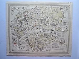
No Binding. Condition: Very Good. colour printed map; overall 38 x 45 cm, image 34 x 43 cm, two horizontal creases along top and lower margin not affecting image; 4 small pin holes in margin corner; a few small tears in top and lower edges not affecting image; o/w vg cond. A very charming map of Historic York by Estra Clark whic…h shows sites, events and people from Roman times to early 19th century, the beginning of the reign of Queen Victoria as well as the city walls. There is a small vignette with 'A Brief History' to the lower right hand, decorated with a jester and a windrose. In the lower left corner is the title cartouche, embellished with historical figures as well s the coat-of-arms of York. The map is framed by a decorative border. Clark did several historic maps of English towns and regions as well as an Old Testament map of the Holy Land. She was born and bred in York and worked as a mapmaker, commercial artist and a school teacher. There are two versions of this map: one was printed in full colour, the other printed in 3 colours.

- Map
Seller: Geographicus Rare Antique Maps, Brooklyn, NY, U.S.A.Geographicus Rare Antique Maps
Contact seller4-star sellerVery good. Size 21 x 26 Inches. A stunning 1947 pictorial map of York, England by the New York artist Estra Clark. Oriented to the North East, this map illustrates central York between the River Foss (Browney Dyke) and the River Ouse. It focuses on York's mediaeval buildings, both those that remained in 1947, and those that were… destroyed. Buildings are represented in vignette fashion, along with annotations, and illustrations of local personalities and characters from folklore. This is one of Clark's first, if not the first, published maps. Publication History and Census This map was drawn by Estra Clark and printed by Ben Johnson and Company of York. There seem to be at least two variants, one, as here in full color, and a 2-color variant. References: Rumsey 8546.000. OCLC 756786049.


