Order Total (1 Item Items):
Shipping Destination:

Claude Joseph Sauthier (6 results)
Feedback
Skip to main search results
Search filters
Product Type
- All Product Types
- Books (2)
- Magazines & Periodicals (No further results match this refinement)
- Comics (No further results match this refinement)
- Sheet Music (No further results match this refinement)
- Art, Prints & Posters (1)
- Photographs (No further results match this refinement)
- Maps (3)
- Manuscripts & Paper Collectibles (No further results match this refinement)
Condition Learn more
- New (No further results match this refinement)
- As New, Fine or Near Fine (No further results match this refinement)
- Very Good or Good (2)
- Fair or Poor (No further results match this refinement)
- As Described (4)
Binding
- All Bindings
- Hardcover (No further results match this refinement)
- Softcover (No further results match this refinement)
Collectible Attributes
- First Edition (No further results match this refinement)
- Signed (No further results match this refinement)
- Dust Jacket (No further results match this refinement)
- Seller-Supplied Images (6)
- Not Print on Demand (6)
Language (1)
Price
- Any Price
- Under US$ 25 (No further results match this refinement)
- US$ 25 to US$ 50 (No further results match this refinement)
- Over US$ 50
Free Shipping
Seller Location
Seller Rating
-

A Topographical Map of the Northern Part of New York Island, Exhibiting the Plan of Fort Washington, now Fort Knyphausen, with the Rebels Lines to the Southward, which were Forced by the Troops under the Command of the Rt. Honble. Earl Percy, on the 16th Novr 1776, and Survey'd immediately after by Claude Joseph Sauthier. To which is added the Attack made to the Northd. By the Hessians. Survey'd by Order of Lieut. Genl. Knyphausen
Published by William Faden, London, 1777
Seller: Donald A. Heald Rare Books (ABAA), New York, NY, U.S.A.
Seller rating 4 out of 5 stars

Map
Copper-engraved map, with original colour to the rivers and battle elements, in excellent condition. One of the very few Revolutionary War battle plans that relate to the City of New York. Sauthier's delineation of upper Manhattan was the most accurate and detailed to date. After the British occupation of New York, George Washington evacuated Manhattan, with the exception of Fort Washington at the northern tip of the island. The British under Sir William Howe moved north and attacked the main American army at White Plains in October 1776. However, the Americans still retained control of Fort Washington behind their forward lines. On November 16, the British mounted a six-column attack on the fort that forced the patriots to surrender. Washington's decision not to evacuate Fort Washington was one of his most serious tactical errors of the war. Almost three thousand men were taken prisoner and the British seized large quantities of supplies and weapons. Four days later General Cornwallis was sent to take Fort Lee on the opposite New Jersey shore, but the Americans stationed there had retreated. Sauthier illustrated the four phases of the attack with the letters A through D. The key at the right identifies the first attack as that by General Knyphausen, the second by Matthews and Cornwallis, the third as a feint, and the fourth by Lord Percy. Sauthier's original manuscript, on which the present map is based, currently resides in the Faden Collection at the Library of Congress. Cumming, British Maps of Colonial America, pp. 72-74; Guthorn, British Maps of the American Revolution, 100/5 & 12; Nebenzahl, Atlas of the American Revolution, pp. 90-91; Nebenzahl, Bibliography of Printed Battle Plans of the American Revolution, 116; Wallis, The American War of Independence, 116.
-

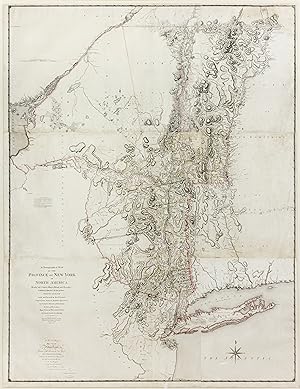
Chorographical Map of the Province of New York
Published by London, London, 1779
Seller: High Ridge Books, Inc. - ABAA, South Deerfield, MA, U.S.A.
Association Member: ABAA ESA ILAB SNEAB
Seller rating 5 out of 5 stars

fine condition, small separations at some fold junctions, light offsetting. This huge map on six sheets, joined into three, includes the disputed area between New York and New Hampshire which is now Vermont. According to Cumming, p. 23, it is "the culminating cartographic achievement of maps of New York, rapidly improving in quality during the 1770's. It shows the clarity and delicate skill of Sauthier's work as a draftsman." This is among the foundational 18th century maps of Vermont, along with the Romans' Map of the Northern Department and Doolittle's Topographical Map of the State of Vermont from 1789. This map also has the distinction of being the last large-scale map of an American colony. A very rare map provided much greater detail than two large-scale predecessor maps of New York, by Jeffreys and Montressor. Adams, British Headquarters Maps and Sketches Used by Sir Henry Clinton.now preserved in the William L. Clements Library, 118; Cumming, British Maps of Colonial America, pp. 72-74; Phillips, A List of Maps of America, p.505; Sellers & Van Ee, Maps & Charts of North America and & West Indies 1750-1789 , 1070.
-

A Map of the provinces of New-York and New-Jersey, with a part of Pennsylvania and Quebec.
Published by Augsburg: M. A. Lotter, dat. ,, 1777
Seller: Antiquariat Ruthild J�ger, Lueneburg, Germany
Seller rating 2 out of 5 stars

Art / Print / Poster
US$ 5,176.60
Convert currencyUS$ 34.27 shipping from Germany to U.S.A.Quantity: 1 available
Add to basketAltkolor. Kupferstich (in 2 Sectionen), 2 Kartenbl�tter � 58 x 39 (zusammengef�gt 58 x 78 cm). Sehr gut erhalten. * BMC (Maps) IX,253; Tooley, Mapmakers 401+560; Sellers/Van Ee Nr. 1048; McCorcle 777.20; McCorkle 777.20;not in Goss. Seltene Spezialkarte. Sch�nes Exemplar der detaillierten Karte der Staaten New York und New Jersey, vom Delaware bis Lake Ontario, Martha's Vineyard und bis an den St.Lorenz-Strom reichend. C. J. Sauthier (1736-1802) war der bedeutendste Landmesser des Staates New York im sp�ten 18. Jahrhundert. A fresh and uncut copy of this large and rare 18th century map (covering the area between Lake Ontario, Montreal, Boston and Baltimore) in two sheets (not joined); giving good detail of the area between Lake Ontario, Montreal, Boston and Baltimore, printed from two plates, loose as issued, in fresh contemporary colouring, "Engraved and published by Matthew Albert Lotter, Augsburg 1777". The map was designed after the topographical observations of Sauthier and based on the Meridian of New York (=74 degrees W from Greenwich). C. J. Sauthier was a German surveyor from Strassburg who immigrated to Carolina. He is known especially as a surveyor in the employ of the Governor William Tryon of New York, a formerly British Major-General. Sauthier's first map of the Province, including surveys by Bernard Ratzer as well as his own, was published in 1776. The boundaries of the regions are clearly indicated by an engraved printed and coloured line, and elsewhere in the provinces, much place-name detail is given. A rare map in very good condition (if two sheets pasted together, the size is 58 x 78 cm).
-
A Chorographical Map of the Province of New York in North America
Published by London: William Faden, 1779., 1779
Seller: Arader Galleries - AraderNYC, New York, NY, U.S.A.
Seller rating 5 out of 5 stars
Map
No Binding. Condition: Good. Fine engraved map on six sheets joined, framed (72 x 56 inches; framed 28 x 64 inches). A MAGNIFICENT MAP OF NEW YORK, with original hand-colour in outline, the title and dedication lower left, key middle right. This map by Claude Joseph Sauthier is one of the most celebrated maps of New York of the entire colonial period. It shows all existing towns, counties, and major roads, and gives an excellent portrait of the extent of settlement (still largely confined to the Hudson Valley). Western New York is portrayed as a vast wilderness and is, thus, labeled simply as "Country of the Six Nations, Indian Country." C.J. Sauthier was born on November 10, 1736 in Strasbourg, (Alsace) France. He received training as a draftsman and illustrator, and early in life was greatly inspired by the master gardeners Dezallier d'Argenville and Alexandre Le Blond). In 1763 Sauthier wrote his first great work, A Treatis on Public Architecture and Garden Planning. Sauthier arrived in North America in 1767, accompanying then British Royal Governor of North Carolina, William Tryon, around the Province. Between 1768 and 1771, Sauthier dedicated himself to mapping towns (and even one camp and battlefield) in North Carolina, all of which were deemed militarily important to the British government. (During his lifetime, Sauther also created superb maps of Bath, Beaufort, Brunswick, Cross Creek (now Fayatteville), Edenton, Halifax, Hillsborough, New Bern, Salisbury, Wilmington and the Camp and Battlefield of Alamance.) Today, these maps form part of King George III's esteemed Topographical Collection at the British Library, though some are also contained in the collections of the Public Record Office in London, the North Carolina Division of Archives and History in Raleigh, North Carolina, and the Clinton Collection at the William L. Clements Library of the University of Michigan. During this time period, Sauthier also played a key role in the planning of the Tryon Palace gardens in New Bern. In 1771, Sauthier left North Carolina with Tryon. That year Tryon rose to the position of Governor of New York and Sauthier was appointed surveyor of the Province of New York by Tryon. Thus, Sauthier's efforts were crucial to the surveying of the boundary between New York and Quebec. Nevertheless, it was the American Revolution that most cemented Sauthier's status as a master surveyor and mapmaker. Indeed, the maps Sauthier produced during this period were of incalculable military importance to the British government. On July 12, 1776, British General William Howe arrived on Staten Island and asked Sauthier to survey and produce a map of the island. Soon after making this request, General Howe successfully captured the City of New York. In addition, after British General Hugh Percy (commander of the 5th Regiment of Foot) made his successful attack on Fort Washington (at the northern tip of Manhattan Island) in November 1776, he, like General Howe, requested that Sauthier survey and map the area. Moreover, General Percy grew to like Sauthier so much that he asked him to accompany his British forces up to Newport, Rhode Island. Sauthier also chose to join Percy at his ancestral home at Alnwick Castle in England following the country's defeat in the war. Sauthier worked as Percy's private secretary. Inventory #: JEL00005.
-
A Map of The Provinces of New-York and New Jersey, with Part of Quebec
Published by Tobias Conrad Lotter, Augsburg, 1777
Seller: James Cummins Bookseller, ABAA, New York, NY, U.S.A.
Seller rating 4 out of 5 stars
Hand-colored map. Engraved by Tobias Conrad Lotter. 1 vols. 30-1/8 x 22-1/4 inces (765 x 565 mm) 2 sheets. This map is Lotter's German edition of Sauthier's map of 1776 done by William Faden. Minor creasing, light toning, original reinforcement on verso of joint. Framed but without glass Hand-colored map. Engraved by Tobias Conrad Lotter. 1 vols. 30-1/8 x 22-1/4 inces (765 x 565 mm) 2 sheets.
-

Mappa Geographica Provinciae Novae Eboraci ab Anglis New York
Published by Nuremburg, 1778
Seller: Alexandre Antique Prints, Maps & Books, Toronto, ON, Canada
Seller rating 5 out of 5 stars
Map
US$ 1,500.00
Convert currencyUS$ 6.00 shipping from Canada to U.S.A.Quantity: 1 available
Add to basketCondition: Very Good. An important revolutionary map of New York and New Jersey. Sauthier was a prominent surveyor and topographer. He arrived in America in 1767 as surveyor for Governor Tryon of North Carolina, moved to New York when Tryon was Governor in 1771. He made extensive plans of New York City and the surrounding area. He was appointed surveyor for the Province of New York; sometime collaborator with Benard Ratzer. He was Military draughtsman during the American Revolution. (Tooley), Size : 735x590 (mm), 28.875x23.25 (Inches), Hand Colored in Outline, 0.