Close Colonel Charles (18 results)

Language: English
Published by His Majestys Stationery Office, London 1925
- Hardcover
Seller: Malcolm Orchard, Salisbury, , United KingdomMalcolm Orchard
Contact seller5-star sellerCondition: Used - Very good
US$ 27.26
US$ 28.91 shippingShips from United Kingdom to U.S.A.Quantity: 1 available
Hardcover. Condition: Very Good. 3rd Edition. Third edition, Eighteenth Thousand, 1925. 566 pages. Illustrated. Folding maps. Original cloth. Very Good.
 More images
Published by Chatham. Published by the Institution of Royal Engineers. 1926 1926
- Hardcover
Seller: J. Patrick McGahern Books Inc. (ABAC), Ottawa, ON, CanadaJ. Patrick McGahern Books Inc. (ABAC)
Contact seller4-star sellerCondition: Used
US$ 29.08
US$ 10.00 shippingShips from Canada to U.S.A.Quantity: 1 available
hard cover. tall 8vo, 24.5cm, 157p., frontis, 15 illustrations, dark blue cloth, gilt titles on spine & front, near fine (cmt). - A history of the Ordnance Survey between 1746 and 1846 reprinted from the "Royal Engineers Journal". The first ordnance map issued for public use by the Survey was of Kent, in 1795.

Published by His Majesty's Stationery Office 1925 (3rd edition) 1925
- Hardcover
Seller: Hard to Find Books NZ (Internet) Ltd., Dunedin, OTAGO, New ZealandHard to Find Books NZ (Internet) Ltd.
Contact seller5-star sellerCondition: Used
US$ 23.65
US$ 20.71 shippingShips from New Zealand to U.S.A.Quantity: 1 available
Quarto, red cloth boards with gilt lettering to spine, page edges stained mottled red, iv + 366pp, illus plus folding map in pocket at rear, VG- (moderately heavy soiling & staining to boards, fading & browning to spine, heavy browning to page edges, dampstaining to fep edges,). Boards are VG- but text block is VG.

Published by Published by David & Charles Ltd., Brunel House, Newton Abbot, Devon Reprinted Edition . 1969. 1969
- Hardcover
Seller: Little Stour Books PBFA Member, Canterbury, United KingdomLittle Stour Books PBFA Member
Contact seller5-star sellerCondition: Used - Very good
US$ 10.90
US$ 39.69 shippingShips from United Kingdom to U.S.A.Quantity: 1 available
Condition: Very Good. Reprinted edition hard back binding in publisher's original tangerine cloth covered boards, blocked and lettered gilt back. 8vo. 8½'' x 6''. Contains (xxxv),164 pp with monochrome and maps and illustrations throughout. Fine condition book in Very Good condition dust wrapper with sun fading down the spine. M…ember of the P.B.F.A. CARTOGRAPHY, MAPS, PLANS.
Published by His Majesty's Stationery Office 1925 1925
- Hardcover
Seller: Hard to Find Books NZ (Internet) Ltd., Dunedin, OTAGO, New ZealandHard to Find Books NZ (Internet) Ltd.
Contact seller5-star sellerCondition: Used
US$ 33.99
US$ 20.71 shippingShips from New Zealand to U.S.A.Quantity: 1 available
Imperial octavo, red buckram boards, gilt lettering to spine, blind rule to boards, red speckling to page edges, pocket to rear pastedown (maps NOT included), iv + 366pp, illus/plates/maps- not counted presumed all present, VG- (light bruising to extrems, heavy scuffing & staining to boards, light tanning to page edges, prev. ow…ners' names in ink to both pastedowns, occasional foxing to pgs sporadically throughout).
Published by Published by Colonel Sir Charles Close and Printed at the Ordnance Survey Office Southampton Revised Edition . 1919. 1919
- Hardcover
Seller: Little Stour Books PBFA Member, Canterbury, United KingdomLittle Stour Books PBFA Member
Contact seller5-star sellerCondition: Used
US$ 20.44
US$ 39.69 shippingShips from United Kingdom to U.S.A.Quantity: 1 available
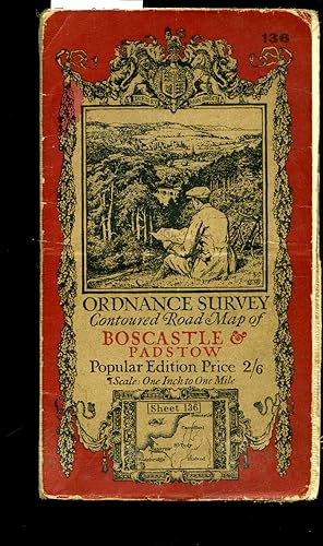
Original russet and beige paper front cover with an illustration by Ellis Martin of a man sitting on a hillside with a map and bicycle, small inset map section. This revised edition first printed in 1919 and without print code). Cloth backed paper folded 21 + 7 half section map opening to 27'' x 24''. Popular Edition Price 2/6.…One Inch to One Mile. Splits to the folded lines. Member of the P.B.F.A. CORNWALL (Kernow).

Published by Published by Colonel Sir Charles Close and Printed at the Ordnance Survey Office Southampton . 1938. 1938
- Hardcover
Seller: Little Stour Books PBFA Member, Canterbury, United KingdomLittle Stour Books PBFA Member
Contact seller5-star sellerCondition: Used
US$ 20.44
US$ 39.69 shippingShips from United Kingdom to U.S.A.Quantity: 1 available
Original russet and beige paper front cover with an illustration by Ellis Martin of a man sitting on a hillside with a map and bicycle, small inset map section. First printed in 1925, this is a reprint from 1938 (print code 3038). Cloth backed paper folded 21 section map opening to 30'' x 21''. Popular Edition Price 2/6. One Inc…h to One Mile. Rubbing to the covers, small holes to the cross corners. Member of the P.B.F.A. YORKSHIRE (Jórvík).

Published by Published by Ordnance Survey Office Chessington, Surrey . 1913. 1913
- Hardcover
Seller: Little Stour Books PBFA Member, Canterbury, United KingdomLittle Stour Books PBFA Member
Contact seller5-star sellerCondition: Used - Very good
US$ 20.44
US$ 39.69 shippingShips from United Kingdom to U.S.A.Quantity: 1 available
Condition: Very Good. Folding cloth backed colour map 25" x 31". Foxing to outside covers and edges, no tears and in Very Good clean condition. Member of the P.B.F.A. CARTOGRAPHY, MAPS, PLANS.

Published by Published by Colonel Sir Charles Close and Printed at the Ordnance Survey Office Southampton . 1927. 1927
- Hardcover
Seller: Little Stour Books PBFA Member, Canterbury, United KingdomLittle Stour Books PBFA Member
Contact seller5-star sellerCondition: Used
US$ 20.44
US$ 39.69 shippingShips from United Kingdom to U.S.A.Quantity: 1 available
The Half-Inch Layered series in green and beige paper front cover with open-top car and signpost illustration by Ellis Martin. First printed in 1915, this is a reprint from 1927 (print code 5000/27). Cloth backed paper folded 24 section map opening to 30'' x 21''. Three Shillings Edition ½ Inch to 1 Mile. With small slits to the… folded cross corners. Member of the P.B.F.A. YORKSHIRE (Jórvík).
 More images
Published by His Majestyâs Stationery Office 1925
- Hardcover
Seller: Hall of Books, Shropshire, United KingdomHall of Books
Contact seller5-star sellerCondition: Used - Very good
US$ 40.82
US$ 21.10 shippingShips from United Kingdom to U.S.A.Quantity: 1 available
Hardback. Condition: Very Good. Third edition hardback, 1925, with no jacket. In overall very good used condition with only minor signs of age, handling and storage - boards slightly rubbed with a couple of light marks. Binding tight and appears little read. Internally clean, no annotation or inscriptions - ownership signature t…o front pastedown dated 1940; text, diagrams, maps, tables and plates (some folding) bright and clear throughout. Photographs available. Not an old library book.
Published by Published by Colonel Sir Charles Close and Printed at the Ordnance Survey Office Southampton . London 1920. 1920
- Hardcover
Seller: Little Stour Books PBFA Member, Canterbury, United KingdomLittle Stour Books PBFA Member
Contact seller5-star sellerCondition: Used
US$ 27.26
US$ 39.69 shippingShips from United Kingdom to U.S.A.Quantity: 1 available
Original russet and beige paper front cover with an illustration by Ellis Martin of a man sitting on a hillside with a map and bicycle, small inset map section. Cloth backed paper folded 24 section map opening to 30'' x 21''. Popular Edition Price 2/6. One Inch to One Mile. Thin brown stain across the horizontal crease lines, no… tears. Member of the P.B.F.A. SUSSEX [Eastbourne].

Published by Published by Colonel Sir Charles Close and Printed at the Ordnance Survey Office Southampton . London 1921. 1921
- Hardcover
Seller: Little Stour Books PBFA Member, Canterbury, United KingdomLittle Stour Books PBFA Member
Contact seller5-star sellerCondition: Used - Very good
US$ 27.26
US$ 39.69 shippingShips from United Kingdom to U.S.A.Quantity: 1 available
Condition: Very Good. Original russet and beige paper front cover with an illustration by Ellis Martin of a man sitting on a hillside with a map and bicycle, small inset map section. Cloth backed paper folded 24 section map opening to 30'' x 21''. Popular Edition Price 2/6. One Inch to One Mile. In Very Good clean and neat condi…tion, no tears. Member of the P.B.F.A. SUSSEX [Hastings].

Published by Published by Colonel Sir Charles Close and Printed at the Ordnance Survey Office Southampton . London 1922. 1922
- Hardcover
Seller: Little Stour Books PBFA Member, Canterbury, United KingdomLittle Stour Books PBFA Member
Contact seller5-star sellerCondition: Used - Very good
US$ 27.26
US$ 39.69 shippingShips from United Kingdom to U.S.A.Quantity: 1 available
Condition: Very Good. Original russet and beige paper front cover with an illustration by Ellis Martin of a man sitting on a hillside with a map and bicycle, small inset map section. Cloth backed paper folded 20 section map opening to 22'' x 35''. Popular Edition Price 2/6. One Inch to One Mile. In Very Good clean and neat condi…tion, no tears. Member of the P.B.F.A. WALES & WELSH LITERATURE.

Published by Published by Colonel Sir Charles Close and Printed at the Ordnance Survey Office Southampton . Southampton 1919. 1919
- Hardcover
Seller: Little Stour Books PBFA Member, Canterbury, United KingdomLittle Stour Books PBFA Member
Contact seller5-star sellerCondition: Used - Very good
US$ 29.98
US$ 39.69 shippingShips from United Kingdom to U.S.A.Quantity: 1 available
Condition: Very Good. Original russet and beige paper front cover with an illustration by Ellis Martin of a man sitting on a hillside with a map and bicycle, small inset map section. Cloth backed paper folded 24 section map opening to 24'' x 25''. Popular Edition Price 2/6. One Inch to One Mile. In Very Good condition with light… soiling to the covers and the folded sections, no tears. Member of the P.B.F.A. DEVONSHIRE (Dumnonia).

Published by Published by Colonel Sir Charles Close and Printed at the Ordnance Survey Office Southampton . London 1922. 1922
- Hardcover
Seller: Little Stour Books PBFA Member, Canterbury, United KingdomLittle Stour Books PBFA Member
Contact seller5-star sellerCondition: Used - Very good
US$ 40.88
US$ 39.69 shippingShips from United Kingdom to U.S.A.Quantity: 1 available
Condition: Very Good. Original russet and beige paper front cover with an illustration by Ellis Martin of a man sitting on a hillside with a map and bicycle, small inset map section. Cloth backed paper folded 36 section map opening to 38'' x 26''. Popular Edition Price 2/6. One Inch to One Mile. In Very Good clean and neat condi…tion, no tears. Member of the P.B.F.A. WALES & WELSH LITERATURE.
Seller: Oast Park Books, Southend -on- Sea, ESSEX, United KingdomOast Park Books
Contact seller5-star sellerCondition: Used
US$ 29.98
US$ 26.46 shippingShips from United Kingdom to U.S.A.Quantity: 1 available
1969. David and Charles Reprints. Hardback. Book - Fair, ex-lib, a little shaken.
 More images
- Softcover
- Map
Seller: Versandantiquariat Funke, Dresden, GermanyVersandantiquariat Funke
Contact seller4-star sellerCondition: Used - Near fine
US$ 35.45
US$ 63.23 shippingShips from Germany to U.S.A.Quantity: 1 available
Condition: guter bis sehr guter Zustand. guter bis sehr guter Zustand, geringe Gebrauchs- und Alterungsspuren: Umschlag an Ecken und Kanten teils etwas abgenutzt, teils mit kleinen Blessuren - Karte sauber und ordentlich Engraved 1872-1885, published 1887-90, Revisited in 1892 and 1902, Revisited in 1914, printed in 1919, Reprin…t 1930 Buchreihe: One-Inch Map of Great Britain, Sheet 94 Format: ca. 11 x 19 (Plan aufgeklappt ca. 74 x 56) kartoniert / Papier Englisch.


