
Order Total (1 Item Items):
Shipping Destination:

Coloured Manuscript Navigational Map Kagoshima (1 results)
Skip to main search results
Product Type
- All Product Types
- Books
- Magazines & Periodicals
- Comics
- Sheet Music
- Art, Prints & Posters
- Photographs
- Maps (1)
-
Manuscripts &
Paper Collectibles
Condition
- All Conditions
- New
- Used
Binding
- All Bindings
- Hardcover
- Softcover
Collectible Attributes
- First Edition
- Signed
- Dust Jacket
- Seller-Supplied Images
- Not Printed On Demand
Seller Location
Seller Rating
-
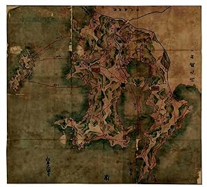
Oh-Sumi-Satsuma-Ryougoku-no Zu .
Published by Matsudaira Ohsumi, 1690
Seller: H�nersdorff Rare Books ABA ILAB, London, United Kingdom
Seller Rating:

Map First Edition
No Binding. Condition: Good. No Jacket. 1st Edition. (JAPAN - Kagoshima peninsula). Oh-Sumi-Satsuma-Ryougoku-no Zu . [Kagoshima ? c1690] Coloured manuscript navigational map painted on paper (99.3 x 109cm ) with landscape and coastlines in coloured pictorial relief of blue, green and grey; charting distances between fortified towns, and nautical miles from ports to neighbouring islands in red; original calligraphic title and seal still visible in top left margin; lower left margin with calligraphic ownership signature for the daimyo Matsudaira Ohsumi-no-kami of the Shimazu clan, chief of the Osumi domain; mounted on paper; artist unknown. Folded in modern blue paper cover on soft cardboard with title inscription repeated. A fine manuscript map of the provinces of Satsuma and Osumi drawn up for its feudal lord, the daimyo Matsudaira Ohsumi-no-kami of the Shimazu clan, probably in order to provide geographical information of his large and politically important domain to the Shogunate which ordered each feudal lord to furnish a map of his fief, as a form of indirect control. The present map may be a copy of the original sent to the shogun. Japan had about 300 daimyo during this period with greatly varying sizes of territory, so that the map of the rich trading southwestern peninsula would have been of special interest to the government. The port city of Kagoshima became the capital of Satsuma province, the feudal territory of the powerful Shimazu clan which also controlled the Osumi domain. Such manuscript maps later provided the basis for a new map of Japan, known as the Genruko Map , completed in 1702. Charted are land and sea routes between the main castle towns and ports of the peninsula, the distances between them and the neighbouring islands. Reference is made to : Yakushima in the south, one of the Osumi islands (famous for its cedarwood - 135 km from Kagoshima), in the west, to the [Koshikijima] islands (not named - 40km from Kagoshima), to the north to : Tanegashima, another Osumi island (known as a historic landing point for the introduction of European firearms to Japan - 115km from Kagoshima), and to the Amakusa islands off the west coast of Kyushu, also ruled by the Shimazu clan during the Edo period (135 km from Kagoshima). An interesting provenance; the powerful daimyo Matsudaira-Ohsumi-no-Kami, chief of Osumi domain, had an annual rice yield of 600,000 koku (- see Kyoto University Economic Review, volume II, 1927, page 45). Repairs to sectional folds, corners & edges; mounted on paper. Generally well preserved.