Connecticut Map (31 results)

Published by Rand, McNally & Co, N.p. 1888
- Map
Seller: Main Street Fine Books & Mss, ABAA, Galena, IL, U.S.A.Main Street Fine Books & Mss, ABAA
Contact seller5-star seller20 3/4" X 14¼" (image 19½" X 12¼"). Printed coloring. Very good. Faintly age toned, with a few small edge tears, but overall attractive. Printed text on verso. Handsome copy of this atlas map.
Published by S. Augustus Mitchell, Jr., New York 1862
- Map
Seller: Main Street Fine Books & Mss, ABAA, Galena, IL, U.S.A.Main Street Fine Books & Mss, ABAA
Contact seller5-star sellerFolio (15¼" X 12¼", image area 14" X 11½"). Hand colored. Very good. Lightly age toned and faintly soiled ; single small discreet stain. Nice example of this tri-state county map, from the 1864 edition of "Mitchell's New General Atlas, Containing Maps of the Various Countries of the World, Plans of Cities, Etc." Well colored and… with sharp floral border.
 More images
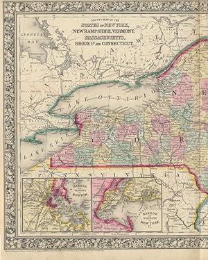
County Map of the States of New York, New Hampshire, Vermont, Massachusetts, Rhode Id. and Connecticut
(NEW YORK -- NEW HAMPSHIRE -- VERMONT -- MASSACHUSETTS -- RHODE ISLAND -- CONNECTICUT -- Map)
Published by S. Augustus Mitchell, Jr., New York 1860
- Map
Seller: Main Street Fine Books & Mss, ABAA, Galena, IL, U.S.A.Main Street Fine Books & Mss, ABAA
Contact seller5-star sellerFolio (23½" X 15¼", image area 21¼" X 13½"). Hand colored. Very good. Slightly age toned and mildly soiled about the edges, with single vertical fold (as issued). Nice centerfold map of New England, from the 1864 edition of "Mitchell's New General Atlas, Containing Maps of the Various Countries of the World, Plans of Cities, Etc…." Two insets at lower left show "Harbor and Vicinity of Boston" and "Harbor and Vicinity of New York." Well colored, with sharp floral border.
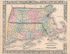
Map of Massachusetts Connecticut and Rhode Island from the latest Authorities.1838.
(Map: Massachusetts, Connecticut, Rhode Island -- Brown & Parsons.)
Published by Published by Brown & Parsons. Hartford. 1838. 1838
- Hardcover
Seller: Bickerstaff's Books, Maps &c., Scarborough, ME, U.S.A.Bickerstaff's Books, Maps &c.
Contact seller4-star sellerIn addition to the three states, this uncommon map encompasses eastern New York state including Long Island. The counties of Massachusetts, Connecticut and Rhode Island are colored. Scarce. This attractively colored map folds into a green leather folder. Folder, embossed with "Massachusetts Connecticut & Rhode Island," is scuffe…d and worn. Map has four quarter-sized spots, perhaps old ink. There are two fold separations of about 1" each, one of which has been mended with archival tape. Map dimensions are 15 x 20." Folds into a case of 5 1/4 x 3 1/4.".
 More images
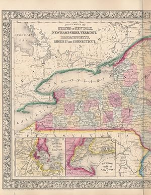
County Map of the States of New York, New Hampshire, Vermont, Massachusetts, Rhode Id. and Connecticut
(NEW YORK -- NEW HAMPSHIRE -- VERMONT -- MASSACHUSETTS -- RHODE ISLAND -- CONNECTICUT -- Map)
Published by S. Augustus Mitchell, Jr., New York 1860
- Map
Seller: Main Street Fine Books & Mss, ABAA, Galena, IL, U.S.A.Main Street Fine Books & Mss, ABAA
Contact seller5-star sellerFolio (23½" X 15¼", image area 21¼" X 13½"). Hand colored. Very good. Faintly age toned, with single vertical fold (as issued). Bright and quite attractive centerfold map of New England, from the 1864 edition of "Mitchell's New General Atlas, Containing Maps of the Various Countries of the World, Plans of Cities, Etc." Two inset…s at lower left show "Harbor and Vicinity of Boston" and "Harbor and Vicinity of New York." Handsomely colored, with fine decorative border.

Published by S. Augustus Mitchell, Jr., New York 1862
- Map
Seller: Main Street Fine Books & Mss, ABAA, Galena, IL, U.S.A.Main Street Fine Books & Mss, ABAA
Contact seller5-star sellerFolio (15¼" X 12¼", image area 14" X 11½"). Hand colored. Very good. Faint age toning only. Handsome example of this tri-state county map, from the 1864 edition of "Mitchell's New General Atlas, Containing Maps of the Various Countries of the World, Plans of Cities, Etc." Sharp, bright coloring and with handsome decorative borde…r.
Published by J.B. Beers & Co, New York 1886
- Map
Seller: Arader Books, New York, NY, U.S.A.Arader Books
Contact seller5-star sellerCondition: Used - Very good
US$ 3,800.00
Free ShippingShips within U.S.A.Quantity: 1 available
No binding. Condition: Very good. One sheet (52" x 46 3/4" sheet, 57 5/8" x 51 3/4" framed). Hand-colored lithograph, mounted on linen. Mild scattered foxing. Slight toning and tearing around the center fold. James Botsford Beers (1811-1901) of the J.B Beers & Co. map publishing firm was born in Connecticut and began publishing…maps and county atlases around 1870. J.B. was the patriarch of the Beers family of map publishers; both his son Frederick W. Beers and his distant cousin John Hobart Beers also published maps and atlases. J.B. Beers published more than 150 county and city atlases and about sixty maps that were offered for sale by the firm. Although he published maps of the whole of the United States, Connecticut was doubtless a special interest, as he was born and buried in Newtown. The map includes a table giving the population as of 1800 and dates of settlement or organization of towns, arranged by Senatorial district, as well as a table giving 1870 and 1880 populations for counties, arranged by Congressional district.

1861 Johnsons Massachusetts Connecticut and Road Island
Antique Map: Johnsons Massachusetts Connecticut and Road Island, 1861
- Map
Seller: New World Cartographic, Chicago, IL, U.S.A.New World Cartographic
Contact seller4-star sellerBy: Johnson and BrowningDate: 1861 (published) New YorkDimensions:17.5 x 24 inches (44.5 x61 cm)This is an original antique map ofMassachusetts, Connecticut, and Rhode Island,published by Johnson andBrowning out of New York in 1861. The map is color coded by county and shows railroads, wagon roads, rivers, canals, ports, major c…ities and villages of the mid-19th century. Notable places of interest include Cape Cod, Marthas Vineyard, Boston, Newport, Portland, and New Haven to name a few.Condition: This map is in A condition with bright and bold coloring on clean paper with ample margins on all sides. Some light paper toning is apparent along the centerfold and outer edges of the page.Inventory #NA1111200 W. 35th Street #425 Chicago, IL 60609 | P: (312) 496 - 3622.

Johnson's Massachusetts, Connecticut, and Rhode Island.
1861 Johnson Map of Massachusetts, Connecticut and Rhode Island
- Map
Seller: Geographicus Rare Antique Maps, Brooklyn, NY, U.S.A.Geographicus Rare Antique Maps
Contact seller4-star sellerVery good. Even overall toning. Verso repair of centerfold separation. Blank on verso. Size 17.75 x 25 Inches. This is an 1861 Johnson and Browning map of Massachusetts, Connecticut, and Rhode Island. The map depicts the region from New York to the Atlantic Ocean and from Vermont and New Hampshire to Long Island Sound and East H…ampton and Montauk. Individual counties in Massachusetts, Connecticut, and Rhode Island are illustrated, labeled, and shaded different colors to allow for easy differentiation. Myriad cities, towns, and villages are labeled throughout, including Boston, Cambridge, Providence, Hartford, and New Haven along with roads, railroads, and canals. Nantucket, Cape Cod and Martha's Vineyard also appear on the map. The whole features the ribbon style border common to Johnson's atlas work from 1860 to 1862. This map is a steel plate engraving prepared by A. J. Johnson for publication as plates no. 25 and 25 in the 1861 edition of his New Illustrated Atlas . This is the last edition of the Johnson's Atlas to bear the Johnson and Browning imprint. References: Rumsey 2905.012.

Johnson's Massachusetts, Connecticut, and Rhode Island.
1862 Johnson Map of Massachusetts, Connecticut and Rhode Island
- First Edition
- Map
Seller: Geographicus Rare Antique Maps, Brooklyn, NY, U.S.A.Geographicus Rare Antique Maps
Contact seller4-star seller1st Edition. Good. Light wear along original centerfold. Verso repairs to centerfold splits and closed margin tears. Text on verso. Size 17.75 x 25 Inches. This is Johnson and Ward's 1862 map of Massachusetts, Connecticut and Rhode Island and it offers a fascinating snapshot of these two New England states shortly following the…outbreak of the American Civil War. The map depicts the region from New York to the Atlantic Ocean and from New Hampshire and Vermont to Long Island and Long Island Sound. Highly detailed, each state features color coding according to county and district, and the ever-expanding transportation network is illustrated, including roads, railroads, and canals. East Hampton and Montauk on Long Island are included along the bottom border, along with Nantucket, Cape Cod and Martha's Vineyard near the right border. The whole is surrounded by the strapwork style border common to Johnson's atlas work from 1860 to 1863. This map is a steel plate engraving prepared by A. J. Johnson for publication in the 1862 edition of his New Illustrated Atlas . This is the first edition of the Johnson's Atlas to bear the Johnson and Ward imprint. References: Rumsey 2905.012 (1860 edition). Phillips (Atlases) 6140,18-19 (1860 editon).

Massachusetts, Rhode Island, and Connecticut.
1842 Greenleaf Map of Massachusetts, Connecticut, Rhode Island
- Map
Seller: Geographicus Rare Antique Maps, Brooklyn, NY, U.S.A.Geographicus Rare Antique Maps
Contact seller4-star sellerVery good. Slight toning and margin foxing. Size 11.5 x 14.5 Inches. This is a beautiful example of Jeremiah Greenleaf's 1842 map of Massachusetts, Rhode Island, and Connecticut. A Closer Look Coverage embraces the three states with color-coding highlighting counties. The overall map reflects the advanced cartographical model es…tablished by local civil and private surveys in the prior decades. The map includes some of the region's earliest railroads, particularly the Boston-Providence Line and the Housatonic Railroad. Publication History and Census This map is a much-revised Greenleaf issue of the David Hugh Burr / 'Illman and Pilbrow' map of 1834. The Burr map plates fell into the hands of Jeremiah Greenleaf, who revised them for publication in his own Universal Atlas . The present example is from the 1842 edition of the atlas, the second Greenleaf edition. References: Rumsey 4850.038.

- First Edition
- Map
Seller: Geographicus Rare Antique Maps, Brooklyn, NY, U.S.A.Geographicus Rare Antique Maps
Contact seller4-star seller1st Edition. Very good. Original platemark visible. Minor spotting at places. Blank on verso. Size 8.5 x 10.5 Inches. This is a fine example of T. G. Bradford's 1835 map of Connecticut and Rhode Island. It covers the two states in detail along with parts of Long Island. Block Island is also included. The map notes rivers, towns,… cities, roads, proposed railroads and canals, with elevation rendered by hachure and color coding according to counties. This map was published as plate no. 29 in Thomas G. Bradford's 1835 Comprehensive Atlas Geographical, Historical and Commercial . Bradford's atlas, published in 1835 was an important work on many levels. First, it was one of the first American atlases to follow an encyclopedic format, offering readers extensive geographical and statistical tables to supplement the maps themselves. Second, it was published in Boston and influenced the city's rise as a publishing center later in the 19th century (at the time most publishing in the United States was restricted to New York and Philadelphia). Third, this atlas was the first to contain a separate and specific map showing the Republic of Texas. Fourth and finally, Bradford's atlas in some instances broke the Euro-centric mold regarding atlas production. Among other things, Bradford focused his atlas on the Americas and abandoned the classical decoration common in European atlases in favor of a more informational and inherently American approach. Bradford published this atlas in several editions and with various partners. The first edition was published by William D. Ticktor and did not contain the iconic Republic of Texas map (although we have in fact seen Ticktor examples with a Texas map, suggesting, against conventional wisdom, that there may have been two Ticktor editions). The second official edition, published in the same year by the American Stationers Company, was the first to contain the Republic of Texas map, which is based on Austin's map, with two pages of descriptive text. A third edition was issued in 1836, also by American Stationers (though still dated 1835), and contained an unaltered Republic of Texas map with only a single page of descriptive test. A fourth edition appeared later, possibly 1837, and included an updated and revised map of Texas that replaces the old Mexican land grants with new inchoate counties. The maps from this atlas are an important addition to any collection focusing on early American cartography and Republic of Texas cartography. All maps in this atlas, though not specifically noted as such, were most likely engraved by G. W. Boynton of Boston, who also engraved most of the maps for Bradford's later publication. References: Rumsey 2643.029 (1838 edition).

- Map
Seller: Geographicus Rare Antique Maps, Brooklyn, NY, U.S.A.Geographicus Rare Antique Maps
Contact seller4-star sellerVery good. Even overall toning. Blank on verso. Size 12 x 14.5 Inches. This is an 1846 Thomas G. Bradford map of Connecticut. The map depicts the region from New York to Rhode Island and from Massachusetts to Long Island Sound. As is the case among many maps from Bradford's A Universal Illustrated Atlas , the recently constructe…d rail network throughout Connecticut is highlighted. Railroads in Connecticut The oldest railroad in the state, the Hartford and New Haven Railroad, was chartered in 1833 and is illustrated here between Hartford and New Haven but is simply labeled 'Rail Road'. This is due to the fact that the Hartford and New Haven merged with the Hartford and Springfield Railroad in 1845, the year before this map was published. The Hartford and Springfield runs north from Hartford and is labeled here, but, as the Hartford and New Haven was technically an extension of this line, it is probable that Bradford elected to not label both lines with the same name. In 1846, the New York and New Haven Railroad, meant to connect New Haven and New York City, was still under construction. The line would not open until 1849 but accomplished what many believed to be a difficult task. The New York and New Haven built along the shore of Long Island Sound, which, due to the many rivers that emptied into Long Island Sound, many believed to be an overly difficult task. When this line was opened, it created a much more direct route between New York and Boston, avoiding a trip north via the New York Central or Boston and Albany lines, or a trip by steamship along the Sound to a harbor in Connecticut, Rhode Island, or Massachusetts. These three lines would merge into the New York, New Haven, and Hartford Railroad in 1872. The Housatonic Railroad, chartered in 1836, is also illustrated near the Connecticut-New York state line. The Housatonic operated from 1840 until 1971, on one form or another. A new Housatonic Railroad was incorporated in 1983 and operated 2011. Like all of Bradford's maps, each county is illustrated, labeled, and shaded a different color to allow for easy differentiation. Individual townships are also labeled, along with numerous cities and towns, such as Hartford, New Haven, and New London. The Farmington Canal, a private canal built to provide water transportation from New Haven to Hartford and beyond, is also illustrated. This map was engraved by George Boynton and published in the 1846 edition of Bradford and Goodrich's A Universal Illustrated Atlas . References: Rumsey 0089.013 (1838 edition).

- Map
Seller: Geographicus Rare Antique Maps, Brooklyn, NY, U.S.A.Geographicus Rare Antique Maps
Contact seller4-star sellerVery good. Blank on verso. Size 8.75 x 11.5 Inches. This is an 1828 Anthony Finley map of Connecticut. The map depicts the state from New York to Rhode Island and from Massachusetts to Long Island in Finley's classic minimalist style. Rivers, roads, canals, and some topographical features are illustrated. Numerous towns and citi…es are included, such as New Haven, Litchfield, and Norwich. Counties are differentiated by color and labeled. It is very uncommon to find an early 19th century exclusively depicting Connecticut, as most maps of the period bundled it with Rhode Island or Massachusetts. Engraved by Young and Delleker for the 1828 edition of Anthony Finley's General Atlas . References: Rumsey 0285.012 (1831 edition). Phillips (Atlases) 4314, 760, 752, 6045.

- Map
Seller: Geographicus Rare Antique Maps, Brooklyn, NY, U.S.A.Geographicus Rare Antique Maps
Contact seller4-star sellerVery good. Minor foxing and overall toning. Minor edge wear. Size 13 x 16 Inches. An elegant example of S. A. Mitchell's detailed 1849 map of Connecticut. Centered on Hartford and Middlesex, this map covers the entire state of Connecticut extending eastward from Fairfield to Windham and New London. Two insets in the lower right…detail the vicinities of Hartford and New Haven. The upper left quadrant a statistical table listing population in various towns, counties and eras. The whole is engraved and colored in Mitchell's distinctive style with green border work and vivid pastels. Political and topographical features are noted and color coded with elevation rendered by hachure. Mitchell published this chart in his atlas from 1846 to the late 1850s before discontinuing the series and selling his map plates to DeSilver. This map was issued in the 1849 edition of the New Universal Atlas . It was the last edition of that atlas to be published by Mitchell prior to selling the plates and rights to the atlas to Thomas Cowperthwait in 1850. References: Rumsey 0545.013.

- Map
Seller: Geographicus Rare Antique Maps, Brooklyn, NY, U.S.A.Geographicus Rare Antique Maps
Contact seller4-star sellerVery good condition. Blank on verso. Size 13 x 16 Inches. An elegant example of S. A. Mitchell's detailed 1854 map of Connecticut. Centered on Hartford and Middlesex, this map covers the entire state of Connecticut extending eastward from Fairfield to Windham and New London. Two insets in the lower right detail the vicinities of… Hartford and New Haven. The upper left quadrant a statistical table listing population in various towns, counties and eras. The whole is engraved and colored in Mitchell's distinctive style with green border work and vivid pastels. Political and topographical features are noted and color coded with elevation rendered by hachure. This map was prepared by S. A. Mitchell for publication by the Philadelphia firm of Thomas Cowperthwait & Co. as plate no. 9 in the 1854 edition of Mitchell's New General Atlas . Dated and copyrighted, 'Entered according to act of Congress in the year 1850 by Thomas Cowperthwait & Co. in the Clerk's office of the Eastern District of Pennsylvania. References: Rumsey 0537.010 (1846 edition). Phillips (Atlases) 814.

Massachusetts, Rhode Island and Connecticut.
1835 Burr Map of New England (Massachusetts, Connecticut and Rhode Island)
- First Edition
- Map
Seller: Geographicus Rare Antique Maps, Brooklyn, NY, U.S.A.Geographicus Rare Antique Maps
Contact seller4-star seller1st Edition. Very good. Original platemark visible. Minor wear along original centerfold. Blank on verso. Minor spotting here and there, especially in margins. Size 11 x 13 Inches. This is a fine first edition 1835 map of Massachusetts, Connecticut and Rhode Island by David H. Burr. It covers the New England states in their enti…rety, with color coding according to counties. Notes several important towns, cities, roads, rivers and topography throughout, with relief shown by hachures. According to Ristow, Although Burr is credited on the title page, he left this atlas incomplete. He was appointed as topographer to the U.S. Post Office, and of the sixty three maps finally included in this atlas, only completed eight. The rest of the maps were then completed by Illman and Pilbrow in Burr's style. This map was 'Entered according to act of Congress Feb 17th in the year 1835 by Thomas Illman, in the Clerk's office of the District Court of New York. References: Rumsey 4628.038. Philips (Atlases) 771-38,1379a-38.

Railroad and Township Map of Massachusetts.
1882 Williams Railroad Map of Massachusetts, Connecticut, and Rhode Island
- Map
Seller: Geographicus Rare Antique Maps, Brooklyn, NY, U.S.A.Geographicus Rare Antique Maps
Contact seller4-star sellerVery good. Wear along original fold lines. Verso repairs to fold separations. Slight loss at some fold intersections. Size 21.25 x 31.75 Inches. This is an 1882 A. Williams and Company railroad map of Massachusetts, Connecticut, and Rhode Island. Bold black lines detail the railroad network. Distances between stops are noted, pr…oviding detail on travel distances. Among the illustrated railroads are the Boston and Providence Railroad, the New York and New England Railroad, and the Vermont and Massachusetts Railroad. A Closer Look Apart from detailing railroads, the map offers significant supplementary data. Cities and towns are delineated, with populations and valuations. Postroads are noted for those who prefer road travel. Data from the 1880 census for Massachusetts appears in the lower left. Publication History and Census This map was copyrighted by Cook and Ellis in 1876 and published by A. Williams and Company in 1882. We note six examples cataloged in OCLC: Yale University, Wesleyan University, Harvard University, the Boston Athenaeum, the State Library of Massachusetts, and the National Library of Scotland. References: OCLC 8539776.

Map of Massachusetts, Connecticut, and Rhode Island constructed from the Latest Authorities.
1825 Finley Folding Map of Massachusetts, Connecticut, and Rhode Island
- Map
Seller: Geographicus Rare Antique Maps, Brooklyn, NY, U.S.A.Geographicus Rare Antique Maps
Contact seller4-star sellerAverage. Verso repairs to fold separations and at fold intersections. Old verso repairs along fold lines. Wear along fold lines. Slight loss at a fold intersection. Top margin trimmed to border. All other margins very tight. Size 17 x 21.25 Inches. This is an attractive 1825 folding map of southern New England - Massachusetts, C…onnecticut, and Rhode Island - produced by Anthony Finley, James H. Young, and David H. Vance. A Closer Look The states of Massachusetts, Connecticut, and Rhode Island are displayed with counties color-shaded for easy distinction, while portions of New York, New Jersey, Vermont, and New Hampshire also appear. Cities and towns, roads, canals, waterways, mountains, islands, and other features are noted throughout. Population statistics and information on the area of each state is provided in a statistical table at bottom. Boston appears almost as an island, connected by bridges and a narrow 'neck' of land with nearby communities; in the following decades land reclamation would expand the 'neck' considerably to create entire new areas of the city. Another notable feature of the map is the inclusion of some Native American communities, such as the Shincock (Shinnecock) and Montaug (Montaukett or Montauk) Indians on Long Island. Nearby on Manhattan Island, the City of New York stands out prominently, though its expansion was still limited enough that Greenwich Village remained a distinct settlement (it was best known at the time as the home of Newgate Prison, New York's first state penitentiary). One additional point worth noting is the appearance of the Middlesex and Erie ('Grand') Canals. The Middlesex Canal was one of the earliest civil engineering projects in the United States, built between 1793 and 1803. The canal's construction necessitated several innovations that were used on later canals, including the far longer Erie Canal, completed the same year as this map's publication. Although the railway age was beckoning (the earliest railway in New England would be completed in 1827 to carry granite from quarries in Quincy, Massachusetts to the nearby Neponset River), canals would remain the primary means of long-distance inland commercial transportation until the 1840s. Publication History and Census This map was drafted by David H. Vance, engraved by James H. Young, and published by Anthony Finley in 1825 or perhaps 1826. Though missing its covers, it was once a pocket map, rather than the atlas map that appeared in Finley's 1826 edition of the New American Atlas (Rumsey 0278.004) (aside from publication format, there are no noticeable difference between the two). Regardless of publication format, this map went on to form the basis of maps of these states for subsequent American mapmakers, including pocket maps by Mitchell (1831, Rumsey 2714.002, previously sold by us) and Brown and Parsons (also offered by us, MACTRI-brownparsons-1838). The present map is only independently cataloged at the University of Michigan, Yale University, and the American Antiquarian Society.

- Map
Seller: Geographicus Rare Antique Maps, Brooklyn, NY, U.S.A.Geographicus Rare Antique Maps
Contact seller4-star sellerFair. Mended along centerfold split. Light foxing outside border. Size 12 x 14.5 Inches. A fascinating 1795 map of the state of Connecticut, drawn and engraved by Amos Doolittle for Matthew Carey's Carey's American Edition of Guthrie's Geography Improved , the first atlas published in the United States of America. A Closer Look…The state of Connecticut is displayed as divided into counties. Cities and towns, roads, hills, waterways, and other features are noted throughout. Along the coast, points, harbors, beaches, and hazards are all recorded. The lighthouse near New London is the New London Harbor Light, built in 1760, the earliest lighthouse in Connecticut and the only one at the time of this map's publication. Fort Griswold, also near New London, was captured by the British (under Benedict Arnold) during the Revolutionary War in 1781, before being abandoned and recaptured by the Americans. As indicated in a legend at top-left, illustrations mark cities and towns hosting courthouses, including New York City, New Haven, Hartford, Tolland, Litchfield, Danbury, Windham, and New London. The title cartouche includes an illustration of a coastal area with ships on the water, along with the state motto 'Qui transtulit sustinet,' harkening to the state's colonial history. The 'Oblong' Notable in the western part of the state is the 'Oblong,' marked out with a dashed line. This area was the site of disputes between landowners dating back decades, itself the result of a broader territorial dispute between the colonies of New York and Connecticut. Although the colonies had resolved their disagreements in 1731, by setting aside the 'Oblong' as compensation to New York for the Connecticut Panhandle, New York landowners did not always enforce their ownership claims. This laxity allowed squatters to move in and claim rights to the land after several years. This problem was especially acute along the border with Putnam County, New York, owned by the Philipse Family. However, as the family were ardent Loyalists during the American Revolutionary War (1775 - 1783), the problem was mostly resolved at the end of the conflict when their lands were confiscated and the squatters given deeds. Publication History and Census This map was drawn and engraved by Amos Doolittle for inclusion in Matthew Carey's Carey's American Edition of Guthrie's Geography Improved , published in Philadelphia in 1795. The same map also appeared in the largely overlapping Carey's American Atlas , published soon afterwards. Regardless of printing, roughly ten institutions independently catalog this map in the OCLC, though the intermingling of digital and physical examples makes a precise census difficult. References: Rumsey 2542.006. OCLC 5565254, 950941475, 163340530.

- Map
Seller: Geographicus Rare Antique Maps, Brooklyn, NY, U.S.A.Geographicus Rare Antique Maps
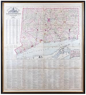
Contact seller4-star sellerGood. Professionally restored and backed with fresh linen. Original rollers. Part of top border missing - see image. Measurement includes rollers. Size 57 x 73 Inches. A 1859 first-edition example of Richard Clark and Robert and George Tackabury's important wall map of Connecticut. When published, it was by far the best and larg…est map of the state obtainable. A Closer Look The map covers the entire state of Connecticut with impressive detail, including topography, color coding by county and township, notes on railroad lines, rivers, and roads, and countless depth soundings along the Long Island Sound. There are multiple insets of Connecticut cities. Drawn on a scale of 1.5 miles to the inch, Clark and Tackabury's map purports to be the most complete map of Connecticut ever published, identifying 'the location of all public buildings, churches, school-houses, manufacturing establishments, and private residences'. Nine insets focus on the cities of Norwalk, New London, Bridgeport, Hartford, Norwich, Middleton, Waterbury, Norwich, Waterbury, Stamford, and New Haven, where Yale College is identified. To the left of the map proper are 1850 census population statistics for both counties and cities arrayed in a table. Publication History and Census The cartography is an amalgam of older maps and new private survey work produced by G. M. Hopkins and Company of Philadelphia. The countless depth soundings along the Long Island Sound are drawn from the U.S. Coast Survey. This is one of the last great wall maps of Connecticut in the 19th-century. It was printed in Philadelphia and sold by subscription in both wall and case format from March 2, 1859. References: Thompson, E., Maps of Connecticut for the Years of the Industrial Revolution, #181.

- Map
Seller: Geographicus Rare Antique Maps, Brooklyn, NY, U.S.A.Geographicus Rare Antique Maps
Contact seller4-star sellerAverage. Toning and some foxing. Laid down on archival tissue. Several large tears, mended and stabilized on verso. Size 21.5 x 21.5 Inches. This is an attractive 1854 schoolgirl manuscript map of Connecticut drawn by 13-year-old Exene E. Tobey of New Canaan. A Closer Look The artfully drawn map covers all of Connecticut and the… eastern forks of Long Island, including Shelter Island, Gardiner's Island, and Fisher Island. The map is contracted on the east-west axis, likely to accommodate the nearly square paper. The whole is whimsically well executed with town, county, and topographical detail. It features a few interesting points of local history, such as Devil's Den in Weston County, where from April 25 to April 27, 1777, residents of Redding and Weston were thought to have taken refuge to escape harassment by a column of British troops marching north from Long Island Sound to destroy a military supply depot in Danbury. It also names Yale University, the Connecticut Literary Institute (Suffield School from 1816), and various religious societies, including the Shakers (Enfield Co.). Exene Toby Exene E. Tobey (1841 - February 1934) was born in New Canaan, Connecticut in 1841, the daughter of George Ephriam Tobey (1745 - 1823) and Abigail Knapp (1751 - 1824). George Ephriam Tobey appears to have been a man of some means and left behind a moderate estate, though the nature of his work remains unknown. Exene married Martin Pratt Fitch (1832 - 1866) in 1858, becoming Exene Tobey Fitch. In 1863, Fitch was drafted to fight the American Civil War (1861 - 1865) and died in 1866 of typhoid contracted during his service. In 1910, the widow Exene married Samuel A. Bennet, becoming Exene Tobey Fitch Bennett. Schoolgirl Maps While the use of mapmaking in teaching is first seen in Europe, mainly England, the Schoolgirl Map became a peculiarly American pedagogical tool in the first part of the 19th Century, a period in which standards and purposes in women's education were changing. While boys were frequently taught the practical execution of surveys and charts, the production of attractive and informative maps appears to have been primarily the domain of young women. Such maps can be found of the world, the United States, or specific states. These were usually based on generally available reference maps, such as those found in the atlases produced by Carey and Lea, Finley, and Mitchell. The goals of these exercises were more far-reaching than teaching geography. Girls learned penmanship, with maps commonly incorporating three or more lettering styles. Mapmaking sharpened the retention and recall of factual information. Students were encouraged to take pains in their draftsmanship and often achieved beautiful flourishes of artistic expression. But most peculiar to the American iterations of educational mapping was the goal of instilling a sense of civic pride and responsibility. Indeed, the key desired result of the education of girls in the post-Revolutionary-War United States was to prepare for the education of the next generation of American citizens, a patriotic duty which would primarily fall on the shoulders of these young women. For a good overview of Schoolgirl Maps, see Betty Mason's '19th Century Schoolgirls Were Incredibly Good at Drawing Maps.' Published July 27, 2016 by National Geographic . Publication History and Census This map is a unique manuscript.
 More images
Colton's Railroad and Township Map of Massachusetts, Rhode Island, and Connecticut, with Parts of Maine, New Hampshire, Vermont, and New York.
1873 Colton Railroad Map of Massachusetts, Connecticut, and Rhode Island
- Map
Seller: Geographicus Rare Antique Maps, Brooklyn, NY, U.S.A.Geographicus Rare Antique Maps
Contact seller4-star sellerFair. Wear along original fold lines. Loss along fold lines and at fold intersections. Old repairs at fold intersections. Light toning. Printer's crease. Size 31.75 x 32.25 Inches. This is a rare 1873 G.W. and C.B. Colton railroad map of Massachusetts, Connecticut, and Rhode Island. A Closer Look Coverage embraces Massachusetts,… Connecticut, and Rhode Island, most of Vermont and New Hampshire, and the lower half of Maine and eastern New York. Townships throughout are shaded and labeled. Cities, towns, and villages are identified, along with mountains and lakes. Black lines highlight the railroad network, from major routes to small regional railroads, almost all of which are named. An inset along the right border depicts New England and Canada from Bennington, Vermont, to Newfoundland, including the Canadian Maritimes. Publication History and Census This map was created by J.H. Colton and published by his sons, G.W. and C.B. Colton, in 1873. We note 4 examples of the 1873 edition cataloged in OCLC: Yale University, the Connecticut Museum of Culture and History, Harvard University, and the Boston Public Library. Also, we note cataloged examples of editions published in 1862, 1866, 1871, 1886, and 1890. Due to cataloging inconsistencies, some of these other editions may represent examples of the 1873. We note only a handful of instances in the last decade when examples of any edition of this map appeared on the private market. References: OCLC 57396467.
 More images
- First Edition
- Map
Seller: Geographicus Rare Antique Maps, Brooklyn, NY, U.S.A.Geographicus Rare Antique Maps
Contact seller4-star seller1st Edition. Good. Original linen backing stable. Overall toning. Some surface abrasion and edge wear. Some dampstaining. Custom clamshell box. Size 57 x 72 Inches. An attractive 1859 first edition example of Richard Clark and Robert and George Tackabury's important wall map of Connecticut. Drawn on a scale of 1.5 miles to the i…nch, this is the largest and most complete map of Connecticut to appear in the 19th century. A Closer Look The map covers Connecticut with detail including topography by hachure, color coding by county and township, notes on railroad lines, rivers, and roads, and countless depth soundings. It identifies 'the location of all public buildings, churches, school-houses, manufacturing establishments, and private residences'. Nine insets focus on the cities of Norwalk, New London, Bridgeport, Hartford, Norwich, Middleton, Waterbury, Norwich, Waterbury, Stamford and New Haven, where Yale College is identified. To the left of the map proper are 1850 census population statistics for both counties and cities arrayed in a table. Sources Cartographically this map is an amalgam of older maps and new private survey work ordered by G. M Hopkins and Company of Philadelphia. The countless depth soundings along the Long Island Sound are drawn from the U.S. Coast Survey. Publication History and Census This map was prepared by Robert M. and George N. Tackabury based upon surveys performed by G. M. Hopkins. It was published by Clark and Tackabury, and printed in Philadelphia by Thomas S. Wagner Lithography. It was sold by subscription in both wall and case format from March 2, 1859. The first edition of this map is scarce - especially as here in dissected format. We note examples of this edition at 4 institutions: Yale University Library, the Connecticut Historical Society, the University of Connecticut, and the Boston Athenaeum. Scarce to the market. References: OCLC 806491344. Thompson, E., Maps of Connecticut for the Years of the Industrial Revolution, #181.
 More images
- Map
Seller: Geographicus Rare Antique Maps, Brooklyn, NY, U.S.A.Geographicus Rare Antique Maps
Contact seller4-star sellerGood. Minimal toning. Varnished over by publisher. Original linen backing stable; some visible wear in upper border images with minor loss. Original rollers. Size 69.6 x 47 Inches. This is a rare 1855 wall map of Hartford County, Connecticut, by Edgar M. Woodford, a native of the county, based in West Avon. A Closer Look Centere…d on the city of Hartford and the Connecticut River, this map covers the county and is color coded by township. Important landmarks, businesses, and the mansions of prominent citizens are depicted in views framing the map. These include the State House in Hartford, State Normal School in New Britain, Connecticut Literary Institution in Suffield, the home of Col. A. G. Hazard in Enfield, the elegant Residence of Wm. H. Jones with View of Silk Factory, the Charter Oak, wildlife, and an Indian Warrior. Property holders and homes are identified throughout. Twenty inset maps surround the central map, including large and detailed town plans of Hartford, Farmington, Rockyhill, New Britain, Wethersfield, Glastonbury (Glastenbury), South Glastonbury (Glastenbury), Windsor Locks, Thompsonville, Broad Brook, Warehouse Point, Plainville, Cheneyville, Southington, Unionville, Collinsville, Hazardville, Plantsville, and Berlin Publication History and Census This map was drawn based upon surveys completed by Edgar M. Woodford in 1855. It was engraved and printed by Wagner and McGuigan, and published by H. and C.T. Smith, both Philadelphia firms. OCLC lists ten examples in institutional collections. Scarce on the market. References: OCLC 793203850. Stephenson, Land Ownership Maps: A Checklist of Nineteenth Century County Maps in the Library of Congresss, #60. Thompson, E., Maps of Connecticut for the Years of the Industrial Revolution, #164. Library of Congress, Map Division, G3783.H3G46 1855 .W6 TIL. Ristow, W., American Maps and Mapmakers: Commercial Cartography in the Nineteenth Century, p. 388.

- First Edition
- Map
Seller: Geographicus Rare Antique Maps, Brooklyn, NY, U.S.A.Geographicus Rare Antique Maps
Contact seller4-star seller1st Edition. Good. Detached from and missing original binder. Some minor damage just encroaching on the left border were once attached to binder - see image. Backed with archival tissue for stability. Size 18.5 x 22.5 Inches. A scarce map, this is Willis Thrall's 1831 pocket map of Connecticut, published in New Haven. It is a fi…ne example of the short-lived but prosperous publishing community once based in Harford and New Haven. A Closer Look Thrall's map, which is dated at bottom center, covers Connecticut as well as the adjacent Long Island Sound. Connecticut is divided into eight color-coded counties. Inset plans of New Haven, Hartford, and the New England States occupy the lower right. The upper right features a profile of the Farmington Canal. A list of Connecticut governors in the upper left, starting with John Winthrop (1665), is updated to include John S. Peters (1831). Publication History and Census According to the Connecticut map historian Edmond Thompson, this map was first engraved by Daggert and issued between 1827 and 1829. This is the second edition, published in 1831 with an update to the list of governors and the names of Thrall and Ely added to the imprint. It was later reissued by different publishers in 1836, 1847, 1854 and 1858. This edition and the virtually unknown first edition are by far the most desirable and found in few collections. It is also noteworthy that this map was published in New Haven, Connecticut. References: Thompson, E., Maps of Connecticut for the Years of the Industrial Revolution 1801-1860, #78.

Map of Massachusetts Connecticut and Rhode Island constructed from the latest authorities.
1838 Brown and Parsons Pocket Map of Massachusetts, Connecticut, and Rhode Island
- Map
Seller: Geographicus Rare Antique Maps, Brooklyn, NY, U.S.A.Geographicus Rare Antique Maps
Contact seller4-star sellerGood. Verso repairs to marginal tears and small areas of loss at fold intersections, and to reinforce fold lines. Discoloration along fold line at left due to earlier adhesive. Light foxing throughout. Size 16.5 x 22 Inches. A hand-colored 1838 pocket map of Massachusetts, Connecticut, and Rhode Island, published by Flavius Brow…n and Edward Parsons. It captures the region in the early days of the railroad boom, when both canals and railroads were being proposed and built at a frenetic pace. A Closer Look Massachusetts, Connecticut, and Rhode Island are presented, divided into counties, which are brightly hand-colored to easily differentiate them (the exception to this rule being Cohasset, an exclave of Norfolk County within Plymouth County, Massachusetts, shaded the same color as the latter). The statistical table at bottom lists the population and area of the states, including the 1820 and 1830 populations of their constituent counties. Cities and towns are identified throughout, along with waterways and elevation, with relief shown by hachures. A legend records the notation for roads, canals, and railroads, including both proposed and existing lines. Early American Railroads This map was produced in the early days of railroads in the United States. Boston emerged as one of the main nodes of early railroad construction and, as can be seen here, already had lines running to the north through Newburyport to Maine, to the west to Worcester, and to the south through Providence to Stonington. Many more routes were proposed throughout the three states at the time of publication. In fact, some of Brown and Parsons' information was a bit out of date, as Plymouth (Old Colony Railroad) and Fall River (Fall River Railroad) had been reached by 1846. At the same time, however, the full length of the Hartford and New Haven Railroad is presented, which was not completed until 1839 (it is likely that, as they were based in Hartford, Brown and Parsons were better informed about the railroad being built towards their hometown from New Haven). It is worth noting that canals also remained an integral mode of transportation, and new canals continued to be proposed even as railways gained momentum as a preferred means of conveying goods and people. Publication History and Census This map was published by Flavius Brown and Edward Parsons in Hartford, Connecticut in 1838. It was originally engraved by D.H. Vance and J.H. Young for Anthony Finley's New American Atlas , published in 1825, and the plate was inherited by Samuel Augustus Mitchell in 1831. Brown and Parsons then inherited the plate from Mitchell and updated it accordingly. The two men published several editions of this map between 1833 and 1849, all of which are quite rare, with each edition held by a small handful of universities. The present edition is only noted among the holdings of the Connecticut State Library and Brown University. References: OCLC 36860559.

- Map
Seller: Geographicus Rare Antique Maps, Brooklyn, NY, U.S.A.Geographicus Rare Antique Maps
Contact seller4-star sellerVery good. Verso repairs to fold separations. Closed tear extending one-and-one-quarter (1.25) inches into printed area from left margin professionally repaired on verso. Size 21.25 x 27.75 Inches. This is a striking 1875 Samuel D. Tilden map of Connecticut in an astounding well-preserved state. With intense color, Tilden's map…focuses on Connecticut's well-established but still growing road and railroad network. A Closer Look Strong color highlights townships across Connecticut. Connecticut's extensive railroad network is detailed, including the Boston, Hartford, and Erie Railroad; the New York, New Haven, and Hartford Railroad; the Connecticut Western Railroad; and the Hartford, Providence, and Fishkill Railroad. Proposed new railroads are marked by dashed black lines. Steamboat lines connecting Norwalk, Bridgeport, Derby, New Haven, Hartford, Norwich, New London, and Stonington with New York City are noted in Long Island Sound. The northeastern most part of Long Island is included along the bottom border with Greenport, Sag Harbor, Shelter Island, and Montauk named. Tables line the left and right borders and detail Connecticut's counties, providing census data for both 1860 and 1870. Publication History and Census This map was published by Samuel D. Tilden and printed in 1875 by Bingham and Dodd. It is well represented in institutional collections. The present example is the cleanest examples to appear on the private market in years. Most known examples varnished and suffer related typical condition issues. The present example is an exception in that it has never been varnished and retains bright original color and strong paper integrity. If this map is on your radar, this is the one you want. References: OCLC 56776624.

- Map
Seller: Geographicus Rare Antique Maps, Brooklyn, NY, U.S.A.Geographicus Rare Antique Maps
Contact seller4-star sellerVery good. Size 20.5 x 28 Inches. This is a rare 1939 Roger Selchow pictorial map of Greenwich, Connecticut, created to celebrate the 300th anniversary of its founding. A Closer Look Depicting Greenwich from Byram Point to Stamford and from The Fincherie Ezekiel Finch House to Elisabeth's Neck and Long Island Sound, Selchow capt…ures the area during the American Revolutionary War (1775 - 1783). Homesteads, taverns, and mills are identified and dated. Stars denote surviving historic buildings. The Indian village, where a 1644 massacre perpetrated by Dutch colonists as part of Kieft's War, is noted. So, too, is the site on Elizabeth's Neck where Captain Daniel Patrick and Robert Feaks landed on July 18, 1640. Greenwich and the American Revolution Most of the annotations highlight events during the American Revolutionary War. Selchow identifies houses plundered and burned by the British and the sloop burned during General Tryon's February 26, 1779, raid. Selchow adds that General Tryon was almost shot in the Evenezer Mead Tavern. A vignette of people firing a cannon remarks that 'at Chimney Corner, citizens drove off British sloop with a cannon'. Charming Details Apart from facts concerning the Revolution, illustrations of fences, flowers, trees, horseback riders, farmers, and wildlife provide charm. The whole is surrounded by a pictorial border decorated with crops along the top and sea creatures along the bottom - underscoring Greenwich's dual agrarian and maritime connections. The title is flanked by a Revolutionary War soldier armed with a musket and an American Indian holding a fishing net and a spear. Six views of 'historic buildings erected after 1800' are illustrated along the left border, and another six views of 'buildings of great fame and beauty' are illustrated along the right. Publication History and Census This map was created by Roger H. Selchow and published in 1939. Selchow also published a companion map of Northern Greenwich (Geographicus: northerngreenwich-selchow-1948-2). The OCLC notes two examples which are part of the collections at the Connecticut Historical Society and the New York Public Library. We are aware of only two other examples that have entered the private market. References: OCLC 38290058.

- First Edition
- Map
Seller: Geographicus Rare Antique Maps, Brooklyn, NY, U.S.A.Geographicus Rare Antique Maps
Contact seller4-star seller1st Edition. Very good. Wear and light toning along original fold lines. Areas of reinforcement along left side where previously attached to binder. Accompanied by original binder. Size 22.75 x 28.25 Inches. This is a strikingly vivid 1852 example of Roderick Nevers' map of Connecticut, Long Island, and eastern New York - publis…hed in Hartford. The map focuses on Connecticut, but emphasizes its connections to New York City via railroads in Connecticut, the Hudson Valley, and Long Island. A Railroad Map To produce this map, Roderick updated William Damerum's excellent map, retooling it to emphasize Connecticut's burgeoning railroad network. Among the railroads present are the New York and New Haven; the New Haven, Hartford, and Springfield; and the Norwich and Worcester. The Hartford, Providence and Fishkill Railroad also appears, along with its proposed route west of Hartford to Fishkill, where it was to meet the Hudson River Railroad. In New York, the Hudson River Railroad runs from Manhattan north to Redhook Landing. The Long Island Railroad stretches across Long Island from Brooklyn to Greenport. Even More Detail Townships are highlighted with vivid wash color. The same level of detail does not translate to eastern New York, where the colors differentiate more generally between counties rather than townships. Towns and villages are labeled along the Hudson, along with other locations such as the U.S. Military Academy at West Point. Topography is loosely rendered with visual depictions of mountains. Publication History and Census This 1852 map was published in Hartford by Roderick Nevers. Per Rumsey, First edition was 1851, a reissue of Damerum's 1815 map. The sixteen stars that surround the eagle in the cartouche stand for the sixteen states in the union when Damerum's plate was engraved by Peter Maverick in 1815, whose plate has been reengraved to produce the map. Stebbins in 1859 produced a map that follows this plate closely. Many changes have been made to the original plate to bring it up to date, particularly the delineation of railroads. While the original Maverick plate would have been in copper or steel, it is likely that this edition was transferred to lithographic stone - as was common in the 1850s. Scarce. We note three examples in OCLC: New York Public Library, the Connecticut Historical Society, and the Connecticut State Library. An example is also part of the David Rumsey Map Collection. Limited market history. References: Rumsey 2562.002. OCLC 20254230.


