Daniel Wallingford (3 results)

Published by Daniel K. Wallingford, Columbia University Bookstore, New York 1936
- Hardcover
Seller: John K King Used & Rare Books, Detroit, MI, U.S.A.John K King Used & Rare Books
Contact seller4-star sellerCondition: Used - Very good
US$ 339.25
US$ 5.50 shippingShips within U.S.A.Quantity: 1 available
Hardcover. Condition: Very Good. Map approximately 14.5 x 19" in brown wood frame 15.5 x 20", printed on brown paper, red and green borders. Very light creasing, light spotting along left side, small light area in upper text else very good condition, frame has scratches and nicks, backing paper is torn and spotted. Not examined…out of frame. The colors are not faded/sunned. Lower right corner shows "Boston and Environs". "A person born in the city of Boston and residing in Boston may not be a Bostonian.The lack of a definite text-book definition for A Bostonian has added to the many difficulties encountered by the Publishers of this map." Extra postage required.

Published by Boston : Daniel K. Wallingford 1939
Seller: Sequitur Books, Boonsboro, MD, U.S.A.Sequitur Books
Contact seller5-star sellerCondition: Used - As new
US$ 275.00
US$ 4.97 shippingShips within U.S.A.Quantity: 1 available
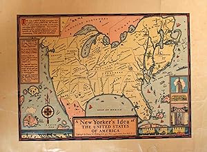
Loose Leaf. Condition: As New. Original print. Third issue, 1939 with the World's Fair, 1939 on Long Island. Uncolored. Mostly clean and unmarked. Far left and bottom. edge has a hint of tanning. This black and white poster is a reprint of a satirical map of the United States by Daniel K. Wallingford. The map represents a "compo…site of New Yorkers' ideas concerning the rest of the United States." The U.S. is reimagined through the collective and biased perspective of New Yorkers who lack interest in the rest of America, since New York is described as a unique "nation within a NATION" and it is drawn in a much larger and disproportional scale than the other de-emphasized states, which are often labeled and described incorrectly. For example, on the map, Minneapolis and Indianapolis are situated in Michigan and listed as The Twin Cities. California has become three separate states, San Francisco, California, and Hollywood, complete with a small figure of a movie director shouting orders in the State of Hollywood. This map is surrounded by an ocean dotted with small ships, and the Empire State Building, the Brooklyn Bridge, and a Fifth Avenue Coach bus are depicted in small boxes on the margins beneath New York State. Wallingford map was first published by The Columbia University Press for the 1936 Times Book Fair and later again for the 1937 fair. This issue was reprinted in 1939 in connection with the New York World's Fair.
Published by New York c. 1939, New York 1939
Seller: High Ridge Books, Inc. - ABAA, South Deerfield, MA, U.S.A.High Ridge Books, Inc. - ABAA
Contact seller5-star sellerWhimsical map of the United States, printed on heavy off-white paper. Some short tears, mended on reverse, and light wear and wrinkling. This is scarce and whimsical 1939 map depicting a New Yorker's idea of the United States by Daniel K. Wallingford. The map depicts a distorted view of the United States, where New York State, M…anhattan and Brooklyn are shown in oversize proportion to the rest of the country. The map is a charming combination of humor and satire, presenting in print the provincialism of New Yorkers, to whom the rest of the country is unimportant. Names of places are either inaccurate or random, demonstrating the presumed lack of interest in such details. For example, southern United States is humorously depicted, with a massive Florida containing the cities of Nashville and New Orleans, and four rivers, each named 'Swanee River.' Louisiana is shown between Alabama and Mississippi. Hollywood and San Francisco, shown as separate states, take up two-thirds of California. Minneapolis and Indianapolis are shown as 'twin cities' in Michigan. Nevada is a city in Reno, New Mexico a city in Texas, etc., etc., etc. The map also includes beautiful illustration of ships, whales, islands etc. The lower right corner of the map includes four small views of New York, including the Empire State building and the Fifth Avenue Coach. Two illustrations along the lower border depict a view of the desert and wagons on the left and a city and cars on the right. Originally published in 1936 by the Columbia University Press, and later in 1937 for the Times Book Fair, this map, larger than the previous two states and colored, can be dated to 1939 as it notes the New York World's Fair. An rare and desireable piece of New York City cartography, predating Saul Steinberg's very similar concept for the New Yorker by 40 years.

