Elwe Jan (58 results)
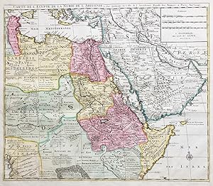
"Carte de l'Egypte, de la Nubie, de l'Abissinie" - Egypt Arabia Ägypten Arabie Red Sea Sudan Somalia Eritrea Africa Afrika Afrique Arabien
Elwe, Jan Barend (active 1777-1815) und Guillaume Delisle (1675-1726):
Language: French
Published by Amsterdam 1792
- Map
Seller: Antiquariat Steffen Völkel GmbH, Seubersdorf, GermanyAntiquariat Steffen Völkel GmbH
Contact seller5-star sellerCondition: Used
US$ 141.67
US$ 34.39 shippingShips from Germany to U.S.A.Quantity: 1 available
Seltene und große altkolorierte Kupferstich-Karte von 1792. -- Blatt-Maße: ca. 54 x 63 cm. --gut erhalten. || Rare hand colored engraved map from 1792. -- in good condition. // Wir, das Antiquariat Steffen Völkel, kaufen und verkaufen alte Bücher, Handschriften, Zeichnungen, Autographen, Grafiken und Fotografien. Wir sind stets…am Ankauf von kompletten Bibliotheken, Sammlungen und Nachlässen interessiert. Sprache: Französisch Gewicht in Gramm: 550.
Language: French
Published by Amsterdam 1792
- Map
Seller: Antiquariat Steffen Völkel GmbH, Seubersdorf, GermanyAntiquariat Steffen Völkel GmbH
Contact seller5-star sellerCondition: Used
US$ 165.27
US$ 34.39 shippingShips from Germany to U.S.A.Quantity: 1 available
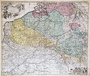
Seltene und große altkolorierte Kupferstich-Karte von 1792. -- Blatt-Maße: ca. 54 x 63 cm. -- gut erhalten. || Rare hand colored engraved map from 1792. Very decorative map of the Low Countries, based on the cartography of Guillaume Delisle. -- in good condition. // Wir, das Antiquariat Steffen Völkel, kaufen und verkaufen alte…Bücher, Handschriften, Zeichnungen, Autographen, Grafiken und Fotografien. Wir sind stets am Ankauf von kompletten Bibliotheken, Sammlungen und Nachlässen interessiert. Sprache: Französisch Gewicht in Gramm: 550.

Language: French
Published by Amsterdam 1792
- Map
Seller: Antiquariat Steffen Völkel GmbH, Seubersdorf, GermanyAntiquariat Steffen Völkel GmbH
Contact seller5-star sellerCondition: Used
US$ 224.30
US$ 34.39 shippingShips from Germany to U.S.A.Quantity: 1 available
Seltene und große altkolorierte Kupferstich-Karte von 1792. -- Blatt-Maße: ca. 54 x 63 cm. -- im unteren Mittelbug hinterlegt, sonst gut erhalten. || Rare hand colored engraved map from 1792. -- deposited on the lower centerfold, otherwise in good condition. || Dies ist ein Original! - Kein Nachdruck! - Keine Kopie! -- This is a…n original! - No copy! - No reprint! // Wir, das Antiquariat Steffen Völkel, kaufen und verkaufen alte Bücher, Handschriften, Zeichnungen, Autographen, Grafiken und Fotografien. Wir sind stets am Ankauf von kompletten Bibliotheken, Sammlungen und Nachlässen interessiert. Sprache: Französisch Gewicht in Gramm: 550.
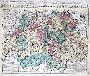
"Nova et accuratissima Helvetiae Foederatarumque cum ea, nec non Subditarum, Regionum Tabula, primum Composita per de l'Isle. | Les Cantons Suisses, leurs Allies & Pays sujets" - Schweiz Suisse Switzerland carte gravure
Elwe, Jan Barend (active 1777-1815) und Guillaume Delisle (1675-1726):
Language: French
Published by Amsterdam 1792
- Map
Seller: Antiquariat Steffen Völkel GmbH, Seubersdorf, GermanyAntiquariat Steffen Völkel GmbH
Contact seller5-star sellerCondition: Used
US$ 224.30
US$ 34.39 shippingShips from Germany to U.S.A.Quantity: 1 available
Seltene und große altkolorierte Kupferstich-Karte von 1792. -- Blatt-Maße: ca. 54 x 63 cm. -- gut erhalten. || Rare hand colored engraved map from 1792. Very decorative map of Switzerland -- in good condition. // Wir, das Antiquariat Steffen Völkel, kaufen und verkaufen alte Bücher, Handschriften, Zeichnungen, Autographen, Grafi…ken und Fotografien. Wir sind stets am Ankauf von kompletten Bibliotheken, Sammlungen und Nachlässen interessiert. Sprache: Französisch Gewicht in Gramm: 550.

Language: French
Published by Amsterdam 1792
- Map
Seller: Antiquariat Steffen Völkel GmbH, Seubersdorf, GermanyAntiquariat Steffen Völkel GmbH
Contact seller5-star sellerCondition: Used
US$ 224.30
US$ 34.39 shippingShips from Germany to U.S.A.Quantity: 1 available
Seltene und große altkolorierte Kupferstich-Karte von 1792. -- Blatt-Maße: ca. 54 x 63 cm. -- im unteren Mittelbug hinterlegt, sonst gut erhalten. || Rare hand colored engraved map from 1792. Very decorative map of Holland and the 7 Provinces. -- deposited on the lower part of the centerfold, otherwise in good condition. || Dies… ist ein Original! - Kein Nachdruck! - Keine Kopie! -- This is an original! - No copy! - No reprint! // Wir, das Antiquariat Steffen Völkel, kaufen und verkaufen alte Bücher, Handschriften, Zeichnungen, Autographen, Grafiken und Fotografien. Wir sind stets am Ankauf von kompletten Bibliotheken, Sammlungen und Nachlässen interessiert. Sprache: Französisch Gewicht in Gramm: 550.

Language: French
Published by Amsterdam 1792
- Map
Seller: Antiquariat Steffen Völkel GmbH, Seubersdorf, GermanyAntiquariat Steffen Völkel GmbH
Contact seller5-star sellerCondition: Used
US$ 259.73
US$ 34.39 shippingShips from Germany to U.S.A.Quantity: 1 available
Seltene und große altkolorierte Kupferstich-Karte von 1792. Von 2 Platten gedruckt. -- Blatt-Maße: jede Karte ca. 54 x 63 cm. -- gut erhalten. || Rare hand colored engraved map from 1792. Rare two sheet map of Delisle's important map of the Russian Empire in Europe. Printed on two plates. -- in good condition. // Wir, das Antiqu…ariat Steffen Völkel, kaufen und verkaufen alte Bücher, Handschriften, Zeichnungen, Autographen, Grafiken und Fotografien. Wir sind stets am Ankauf von kompletten Bibliotheken, Sammlungen und Nachlässen interessiert. Sprache: Französisch Gewicht in Gramm: 550.

Language: French
Published by Amsterdam 1792
- Map
Seller: Antiquariat Steffen Völkel GmbH, Seubersdorf, GermanyAntiquariat Steffen Völkel GmbH
Contact seller5-star sellerCondition: Used
US$ 342.37
US$ 34.39 shippingShips from Germany to U.S.A.Quantity: 1 available
Seltene und große altkolorierte Kupferstich-Karte von 1792. -- Blatt-Maße: ca. 54 x 63 cm. -- im unteren Mittelbug etwas hinterlegt, sonst gut erhalten. || Rare hand colored engraved map from 1792. Large, detailed map of the Holy Land, based on De Wit's map. With an engraving of the Tabernacle surrounded by the 12 tribes and fla…nked by Moses and Aaron. -- somewhat deposited on the lower centerfold, otherwise in good condition. || Dies ist ein Original! - Kein Nachdruck! - Keine Kopie! -- This is an original! - No copy! - No reprint! // Wir, das Antiquariat Steffen Völkel, kaufen und verkaufen alte Bücher, Handschriften, Zeichnungen, Autographen, Grafiken und Fotografien. Wir sind stets am Ankauf von kompletten Bibliotheken, Sammlungen und Nachlässen interessiert. Sprache: Französisch Gewicht in Gramm: 550.

"Les Isles Britanniques qui contiennent les Royaumes d'Angleterre, Escosse, et Irlande distingues en leurs principales provinces" - British Isles Great Britain Ireland Irland United Kingdom Großbritannien
Elwe, Jan Barend (active 1777-1815) und Alexis Hubert Jaillot (1632-1712):
Language: French
Published by Amsterdam 1792
- Map
Seller: Antiquariat Steffen Völkel GmbH, Seubersdorf, GermanyAntiquariat Steffen Völkel GmbH
Contact seller5-star sellerCondition: Used
US$ 342.36
US$ 34.39 shippingShips from Germany to U.S.A.Quantity: 1 available
Seltene und große altkolorierte Kupferstich-Karte von 1792. -- Blatt-Maße: ca. 54 x 63 cm. -- gut erhalten. || Rare hand colored engraved map from 1792. A very decorative map of the British Isles. This is the last state of Jaillot's map. -- in very good condition. || Dies ist ein Original! - Kein Nachdruck! - Keine Kopie! -- Thi…s is an original! - No copy! - No reprint! // Wir, das Antiquariat Steffen Völkel, kaufen und verkaufen alte Bücher, Handschriften, Zeichnungen, Autographen, Grafiken und Fotografien. Wir sind stets am Ankauf von kompletten Bibliotheken, Sammlungen und Nachlässen interessiert. Sprache: Französisch Gewicht in Gramm: 550.

Language: French
Published by Amsterdam 1792
- Map
Seller: Antiquariat Steffen Völkel GmbH, Seubersdorf, GermanyAntiquariat Steffen Völkel GmbH
Contact seller5-star sellerCondition: Used
US$ 377.79
US$ 34.39 shippingShips from Germany to U.S.A.Quantity: 1 available
Seltene und große altkolorierte Kupferstich-Karte von 1792. -- Blatt-Maße: ca. 54 x 63 cm. -- gut erhalten. || Rare hand colored engraved map from 1792. Rare, decorative map of South Africa, including the island of Madagascar, with 2 interesting insets of the Cape of Good Hope. The map is based on Visscher's map of 1710. -- in g…ood condition. // Wir, das Antiquariat Steffen Völkel, kaufen und verkaufen alte Bücher, Handschriften, Zeichnungen, Autographen, Grafiken und Fotografien. Wir sind stets am Ankauf von kompletten Bibliotheken, Sammlungen und Nachlässen interessiert. Sprache: Französisch Gewicht in Gramm: 550.

Language: French
Published by Amsterdam 1792
- Map
Seller: Antiquariat Steffen Völkel GmbH, Seubersdorf, GermanyAntiquariat Steffen Völkel GmbH
Contact seller5-star sellerCondition: Used
US$ 413.21
US$ 34.39 shippingShips from Germany to U.S.A.Quantity: 1 available
Seltene und große altkolorierte Kupferstich-Karte von 1792. -- Blatt-Maße: ca. 54 x 63 cm. -- gut erhalten. || Rare hand colored engraved map from 1792. -- in good condition. || Dies ist ein Original! - Kein Nachdruck! - Keine Kopie! -- This is an original! - No copy! - No reprint! // Wir, das Antiquariat Steffen Völkel, kaufen…und verkaufen alte Bücher, Handschriften, Zeichnungen, Autographen, Grafiken und Fotografien. Wir sind stets am Ankauf von kompletten Bibliotheken, Sammlungen und Nachlässen interessiert. Sprache: Französisch Gewicht in Gramm: 550.

Language: French
Published by Amsterdam 1792
- Map
Seller: Antiquariat Steffen Völkel GmbH, Seubersdorf, GermanyAntiquariat Steffen Völkel GmbH
Contact seller5-star sellerCondition: Used
US$ 460.43
US$ 34.39 shippingShips from Germany to U.S.A.Quantity: 1 available
Seltene und große altkolorierte Kupferstich-Karte von 1792. -- Blatt-Maße: ca. 54 x 63 cm. -- gut erhalten. || Rare hand colored engraved map from 1792. Rare map of Africa, based on Jaillot's influential map from 1674. -- in very good condition. || Dies ist ein Original! - Kein Nachdruck! - Keine Kopie! -- This is an original! -… No copy! - No reprint! // Wir, das Antiquariat Steffen Völkel, kaufen und verkaufen alte Bücher, Handschriften, Zeichnungen, Autographen, Grafiken und Fotografien. Wir sind stets am Ankauf von kompletten Bibliotheken, Sammlungen und Nachlässen interessiert. Sprache: Französisch Gewicht in Gramm: 550.
 More images
Language: French
Published by Jan Barent Elwe, Amsterdam 1792
- Map
Seller: Antiquariaat Dat Narrenschip, Middelburg, NetherlandsAntiquariaat Dat Narrenschip
Contact seller5-star sellerCondition: Used - Very good
US$ 566.68
US$ 30.95 shippingShips from Netherlands to U.S.A.Quantity: 1 available
No Binding. Condition: Very Good. Antique map of India, Tibet, Indochina and surrounding areas in Southeast Asia. Title above the map. Scale sticks in frame lower left. Minor age toning at the bottom center. Copper engraving with nice old color, published in Amsterdam in 1792 by Jan Barent Elwe. Dimensions (picture): 52 x 60 cm.

Language: French
Published by Amsterdam 1792
- Map
Seller: Antiquariat Steffen Völkel GmbH, Seubersdorf, GermanyAntiquariat Steffen Völkel GmbH
Contact seller5-star sellerCondition: Used
US$ 649.33
US$ 34.39 shippingShips from Germany to U.S.A.Quantity: 1 available
Seltene und große altkolorierte Kupferstich-Karte von 1792. -- Blatt-Maße: ca. 54 x 63 cm. -- gut erhalten. || Rare hand colored engraved map from 1792. Large, decorative map, based on the Jaillot-Sanson map from 1674. -- in very good condition. || Dies ist ein Original! - Kein Nachdruck! - Keine Kopie! -- This is an original! -… No copy! - No reprint! // Wir, das Antiquariat Steffen Völkel, kaufen und verkaufen alte Bücher, Handschriften, Zeichnungen, Autographen, Grafiken und Fotografien. Wir sind stets am Ankauf von kompletten Bibliotheken, Sammlungen und Nachlässen interessiert. Sprache: Französisch Gewicht in Gramm: 550.
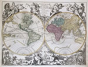
"Mappe Monde ou Description du Globe Terrestre & Aquatique suivant les dernieres & meilleures" - World map Weltkarte Mappemonde California island
Elwe, Jan Barend (active 1777-1815) und Alexis Hubert Jaillot (1632-1712):
Language: French
Published by Amsterdam 1792
- Map
Seller: Antiquariat Steffen Völkel GmbH, Seubersdorf, GermanyAntiquariat Steffen Völkel GmbH
Contact seller5-star sellerCondition: Used
US$ 1,416.71
US$ 34.39 shippingShips from Germany to U.S.A.Quantity: 1 available
Seltene und große altkolorierte Kupferstich-Karte von 1792. -- Blatt-Maße: ca. 54 x 63 cm. -- im unteren Mittelbug etwas hinterlegt, sonst gut erhalten. || Rare hand colored engraved map from 1792. -- Very decorative Dutch world map in the traditional style of 17th century maps. This is probably the last map to show California a…s an island. -- somewhat deposited on the lower centerfold, otherwise in very good condition. || Dies ist ein Original! - Kein Nachdruck! - Keine Kopie! -- This is an original! - No copy! - No reprint! // Wir, das Antiquariat Steffen Völkel, kaufen und verkaufen alte Bücher, Handschriften, Zeichnungen, Autographen, Grafiken und Fotografien. Wir sind stets am Ankauf von kompletten Bibliotheken, Sammlungen und Nachlässen interessiert. Sprache: Französisch Gewicht in Gramm: 550.

Published by Amsterdam: [um ] 1790
- Art Print
Seller: Antiquariat Tautenhahn, Lübeck, , GermanyAntiquariat Tautenhahn
Contact seller5-star sellerCondition: Used
US$ 82.64
US$ 120.35 shippingShips from Germany to U.S.A.Quantity: 1 available
Altkolorierte Radierung 7,5 x 24 cm, Blattgröße 20,5 x 26,5 cm. Die Karte zeigt die Gebiete von Pommern mit Vorpommern sowie Brandenburg mit zahlreichen Details. Die umgebenden Gebiete nur mit den Hauptorten benannt. Unten rechts die Titelkartusche und ein Meilenanzeiger. - Aus: Nieuwe Reis-Atlas van Geheel Deutschland. - Jan Ba…rend Elwe, 1746 - 1818, Geograph. - Das Papier im Bereich des Passepartoutausschnittes deutlich gebräunt, die Darstellung klar und sauber.

Published by Amsterdam 1792
- First Edition
- Art Print
Seller: Trillium Antique Prints & Rare Books, Franklin, TN, U.S.A.Trillium Antique Prints & Rare Books
Contact seller3-star sellerCondition: Used - Fine
US$ 275.00
US$ 10.00 shippingShips within U.S.A.Quantity: 1 available
Condition: Fine. 1st Edition. This first edition, originally hand-colored map is from Jan Berend Elwe's "Atlas". The work was published in Amsterdam for the author circa 1792. --- The frontispiece from the work was engraved by I. van Munnikhuyse after L. Webbers. Most of the maps available from the atlas are dated 1792. Many of…the maps appear to be directly influenced by R. & I. Ottens atlas. (Koeman p. 105) --- The work is in very good to excellent condition overall. There may be a few minor imperfections or fox marks to be expected with age. Please review the image carefully for condition and contact us with any questions. --- Paper Size ~ 25" by 21 1/4" (Fold Out).

Published by Amsterdam 1792
- First Edition
- Art Print
Seller: Trillium Antique Prints & Rare Books, Franklin, TN, U.S.A.Trillium Antique Prints & Rare Books
Contact seller3-star sellerCondition: Used - Fine
US$ 375.00
US$ 10.00 shippingShips within U.S.A.Quantity: 1 available
Condition: Fine. 1st Edition. This first edition, originally hand-colored map is from Jan Berend Elwe's "Atlas". The work was published in Amsterdam for the author circa 1792. --- The frontispiece from the work was engraved by I. van Munnikhuyse after L. Webbers. Most of the maps available from the atlas are dated 1792. Many of…the maps appear to be directly influenced by R. & I. Ottens atlas. (Koeman p. 105) --- The work is in very good to excellent condition overall. There is a light water stain in the upper right corner. There may be a few minor imperfections or fox marks to be expected with age. Please review the image carefully for condition and contact us with any questions. --- Paper Size ~ 25" by 21 1/4" (Fold Out).

Published by Amsterdam 1792
- First Edition
- Art Print
Seller: Trillium Antique Prints & Rare Books, Franklin, TN, U.S.A.Trillium Antique Prints & Rare Books
Contact seller3-star sellerCondition: Used - Fine
US$ 375.00
US$ 10.00 shippingShips within U.S.A.Quantity: 1 available
Condition: Fine. 1st Edition. This first edition, originally hand-colored map is from Jan Berend Elwe's "Atlas". The work was published in Amsterdam for the author circa 1792. --- The frontispiece from the work was engraved by I. van Munnikhuyse after L. Webbers. Most of the maps available from the atlas are dated 1792. Many of…the maps appear to be directly influenced by R. & I. Ottens atlas. (Koeman p. 105) --- The work is in very good to excellent condition overall. There may be a few minor imperfections or fox marks to be expected with age. Please review the image carefully for condition and contact us with any questions. --- Paper Size ~ 25" by 21 1/4" (Fold Out).

Published by Amsterdam 1792
- First Edition
- Art Print
Seller: Trillium Antique Prints & Rare Books, Franklin, TN, U.S.A.Trillium Antique Prints & Rare Books
Contact seller3-star sellerCondition: Used - Fine
US$ 375.00
US$ 10.00 shippingShips within U.S.A.Quantity: 1 available
Condition: Fine. 1st Edition. This first edition, originally hand-colored map is from Jan Berend Elwe's "Atlas". The work was published in Amsterdam for the author circa 1792. --- The frontispiece from the work was engraved by I. van Munnikhuyse after L. Webbers. Most of the maps available from the atlas are dated 1792. Many of…the maps appear to be directly influenced by R. & I. Ottens atlas. (Koeman p. 105) --- The work is in very good to excellent condition overall. There is a light water stain in the upper right corner. There may be a few minor imperfections or fox marks to be expected with age. Please review the image carefully for condition and contact us with any questions. --- Paper Size ~ 25" by 21 1/4" (Fold Out).

Published by Amsterdam 1792
- First Edition
- Art Print
Seller: Trillium Antique Prints & Rare Books, Franklin, TN, U.S.A.Trillium Antique Prints & Rare Books
Contact seller3-star sellerCondition: Used - Fine
US$ 375.00
US$ 10.00 shippingShips within U.S.A.Quantity: 1 available
Condition: Fine. 1st Edition. This first edition, originally hand-colored map is from Jan Berend Elwe's "Atlas". The work was published in Amsterdam for the author circa 1792. --- The frontispiece from the work was engraved by I. van Munnikhuyse after L. Webbers. Most of the maps available from the atlas are dated 1792. Many of…the maps appear to be directly influenced by R. & I. Ottens atlas. (Koeman p. 105) --- The work is in very good to excellent condition overall. There may be a few minor imperfections or fox marks to be expected with age. Please review the image carefully for condition and contact us with any questions. --- Paper Size ~ 25" by 21 1/4" (Fold Out).

Published by Amsterdam 1792
- First Edition
- Art Print
Seller: Trillium Antique Prints & Rare Books, Franklin, TN, U.S.A.Trillium Antique Prints & Rare Books
Contact seller3-star sellerCondition: Used - Fine
US$ 375.00
US$ 10.00 shippingShips within U.S.A.Quantity: 1 available
Condition: Fine. 1st Edition. This first edition, originally hand-colored map is from Jan Berend Elwe's "Atlas". The work was published in Amsterdam for the author circa 1792. --- The frontispiece from the work was engraved by I. van Munnikhuyse after L. Webbers. Most of the maps available from the atlas are dated 1792. Many of…the maps appear to be directly influenced by R. & I. Ottens atlas. (Koeman p. 105) --- The work is in very good to excellent condition overall. There may be a few minor imperfections or fox marks to be expected with age. Please review the image carefully for condition and contact us with any questions. --- Paper Size ~ 25" by 21 1/4" (Fold Out).

Published by Amsterdam. 1792 1792
Seller: Peter Harrington. ABA/ ILAB., London, United KingdomPeter Harrington. ABA/ ILAB.
Contact seller5-star sellerCondition: Used
US$ 442.10
US$ 29.06 shippingShips from United Kingdom to U.S.A.Quantity: 1 available
Elwe was a Dutch 'bookseller and publisher who produced a small number of maps copied from his predecessors.' A map of Italy south from Rome. It shows the Albanian coast, and the northern tip of Sicily in outline. Ornamental cartouche at top right Moreton and Bannister p123 Copper engraving. Very good condition, good margins. Wa…terstain at lower centrefold, not affecting map Original colour. Size: 54 x 44 cm.
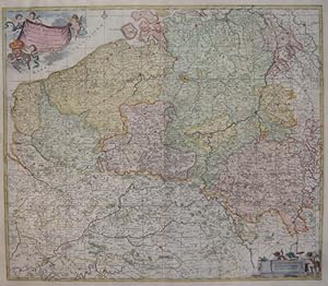
Published by Artist: Elwe Jan Barend ( - 1777 ) Amsterdam dated : 1792 1777
Seller: Antique Sommer& Sapunaru KG, München, , GermanyAntique Sommer& Sapunaru KG
Contact seller4-star sellerCondition: Used
US$ 448.63
US$ 51.58 shippingShips from Germany to U.S.A.Quantity: 1 available
Technic: Copper print, colorit: original colored, condition: Perfect condition, size (in cm): 52 x 60 cm, The ?New Map of the Catholic Netherlands? shows today's entire Belgium, Luxembourg and partly the Netherlands with e.g. Breda and Maastrich. Furthermore, a title cartouche held by three putti and the coat of arms of the Span…ish Netherlands, at the bottom right a mileage cartouche with two putti.


