Order Total (1 Item Items):
Shipping Destination:

End World, Signed (5 results)
Author:
end world
Refine with Advanced Search
Skip to main search results
Search filters
Product Type
- All Product Types
- Books (3)
- Magazines & Periodicals (No further results match this refinement)
- Comics (No further results match this refinement)
- Sheet Music (No further results match this refinement)
- Art, Prints & Posters (No further results match this refinement)
- Photographs (No further results match this refinement)
- Maps (1)
- Manuscripts & Paper Collectibles (1)
Condition Learn more
- New (No further results match this refinement)
- As New, Fine or Near Fine (3)
- Very Good or Good (1)
- Fair or Poor (No further results match this refinement)
- As Described (1)
Binding
- All Bindings
- Hardcover (2)
- Softcover (No further results match this refinement)
Collectible Attributes
Language (2)
Price
- Any Price
- Under US$ 25 (No further results match this refinement)
- US$ 25 to US$ 50
- Over US$ 50
Free Shipping
- Free Shipping to U.S.A. (No further results match this refinement)
Seller Location
Seller Rating
-

Falklands Conflict | The Argentinian (Argentinean) Invasion | Signed First Day Royal Navy Cover Stamped Envelope | In Memory of the Men Who Lost Their Lives When HMS Sheffield Was Hit by an Exocet Missile off The Falkland Islands on 4th May 1982
Published by 4th May ., 1999
Seller: Little Stour Books PBFA Member, Canterbury, United Kingdom
Association Member: PBFA
Seller rating 5 out of 5 stars

Signed
US$ 41.43
US$ 40.22 shipping
Ships from United Kingdom to U.S.A.Quantity: 1 available
Add to basketCondition: Fine. 8�'' x 5''. Certified Copy No. 103 of 150 first day Royal Navy cover stamped envelope. SIGNED 'Sam Salter'. One cachet insert. In Fine condition. Member of the P.B.F.A. FALKLAND ISLANDS.
-
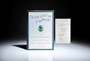
The Putt at the End of the World
Published by Warner Books, New York, 2000
Seller: The First Edition Rare Books, LLC, Cincinnati, OH, U.S.A.
Association Member: ABAA ILAB IOBA MWABA
Seller rating 5 out of 5 stars
First Edition Signed
Hardcover. Condition: Fine. Dust Jacket Condition: fine. Signed first edition of The Putt at the End of the World by Lee K. Abbott, Dave Barry, Richard Bausch, James Crumley, James W. Hall, Tami Hoag, Tim O'Brien, Ridley Pearson, and Les Standiford. (illustrator). First Edition, First Printing. Octavo, [10], 242pp. Black spine, green boards, title in gilt on spine. Solid text block, appears unread, a fine example. In the publisher's dust jacket, $23.95 retail price on front flap, a stunning, fine example. Signed by all nine authors on the half title. The aforementioned nine authors each wrote one chapter to create this piece of fiction. Signed.
-
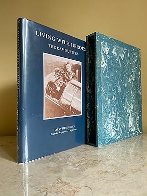
Living with Heroes | The Story of the Dam Busters + (Signed Dam Busters at War | 617 Squadron Flown Cover)
Published by Published by The Erskine Press, The Old Bakery, Banham, Norwich, Norfolk First Edition . 2003., 2003
Seller: Little Stour Books PBFA Member, Canterbury, United Kingdom
Association Member: PBFA
Seller rating 5 out of 5 stars
First Edition Signed
US$ 186.43
US$ 40.22 shipping
Ships from United Kingdom to U.S.A.Quantity: 1 available
Add to basketCondition: Fine. First edition hard back binding in publisher's original scarlet cloth covered boards, blocked and lettered gilt back. Quarto. 9�'' x 7''. Contains (xii)-ii, 129 pp with monochrome archive photographs throughout. Fine condition book in Fine condition dust wrapper, not price clipped. + No. 47 of 50 'Dam Busters at War | 617 Squadron' flown cover SIGNED by the author 'Harry Humphries' to the front cover. Dust wrapper supplied in archive acetate film protection. Housed in Fine condition marble paper covered open-fronted slip case. Member of the P.B.F.A. ROYAL AIR FORCE (RAF).
-
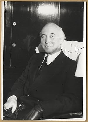
John Simon, 1st Viscount Simon (1873-1954) - Rare signed photo 1934
Language: French
Publication Date: 1934
Manuscript / Paper Collectible Signed
Pas de couverture. Condition: Assez bon. Rare photo signed in 1934. Size : 13x18 cm. Condition : please see scans. Provenance : Yvon Lef�vre collection (30s) Certificate of Authenticity and lifetime guarantee. Sign� par l'auteur.
-

China Front.
Publication Date: 1945
Seller: Geographicus Rare Antique Maps, Brooklyn, NY, U.S.A.
Association Member: ABAA ESA ILAB
Seller rating 4 out of 5 stars

Map Signed
Good. Newsprint. Verso repairs to fold separations. Closed tear extending 2 inches within printed area professionally repaired on verso. Closed tear extending 1.5 inches into printed area from left margin professionally repaired on verso. Closed edge tears professionally repaired on verso. Text and printed images on verso. Size 14.5 x 20.75 Inches. This is a 1945 Edwin Sundberg map of China marking American air bases. It predicts future military operations in the region near the end of World War II (1939 - 1945). Nonetheless, it appeared just 9 days before the atomic bomb was dropped on Hiroshima, Japan, and the end of the Pacific War. A Closer Look The map depicts from Nagasaki (in the upper right corner) south to northern Luzon and from Yunnan to Amami in the Ryukyu Islands. Red stars mark American airbases in southern China. The largest identifies Chongqing (labeled Chungking), Chiang Kai-shek's provisional capital after the 1937 Japanese capture of Nanjing (Nanking). Cities and towns are labeled throughout China, French Indochina, and Japanese Taiwan (Formosa). A short caption in the lower right corner provides additional information, stating that this part of China is where the fighting between the Chinese and Japanese is taking place. It also predicts military operations likely to commence within the next few months. At this time, the Allies had indeed been planning a massive ground operation in southeastern China to capture a port. However, after the atomic bombs were dropped on Hiroshima (August 6) and Nagasaki (August 9), and the Soviets invaded Manchuria (August 9), the Japanese surrendered. Emperor Hirohito announced the surrender on August 15, and it was formally signed on September 2. The Second Sino-Japanese War The Second Sino-Japanese War was fought between the Republic of China and the Empire of Japan. Some disagreement exists as to when the war officially started. Two different 'Incidents' are used to mark the beginning of hostilities. Historically, the July 7, 1937, Marco Polo Bridge Incident is considered the official start, when Chinese and Japanese troops began exchanging fire at the Marco Polo (Lugou) Bridge, along a main access route to Beijing. This exchange of fire escalated into an all-out battle, leading to Japanese forces capturing both Beijing and its port city, Tianjin. Other scholars, and since 2017 the Chinese government, trace the beginning of the Second Sino-Japanese War to the Mukden Incident and the September 1931 Japanese invasion of Manchuria. This 'incident' was based on trumped-up Japanese charges that their rights in Manchuria, which had been guaranteed following the Russo-Japanese War (1904 - 1905), were being infringed upon. More likely, the Japanese simply saw an opportunity to easily capture an essentially limitless supply of raw materials, a new market for their manufactured goods, and create a 'buffer zone' between Japanese-occupied Korea and the Soviet Union. After five months of fighting, in early 1932, the Japanese created the puppet state of Manchukuo and installed Puyi, the last Emperor of China, as its ruler. Even though there is some debate over when the war started, the result is the same: years of war, famine, atrocities, and death. Following the December 7, 1941, Japanese attack on Pearl Harbor, the Second Sino-Japanese War is usually folded into the China-Burma-India Theater of World War II. Although there is some debate on when the war began, there is no doubt when it ended. Following the atomic bombings of Hiroshima and Nagasaki in August 1945, the Japanese unconditionally surrendered to the Allies on September 2, 1945, bringing an end to the largest Asian war of the 20th century. Publication History and Census This map was drawn by Edwin Sundberg and published in the July 29, 1945 edition of the Sunday News . This is the only known cataloged example. Signed by Author(s).