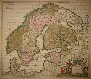
Frederick Wit 1630 (84 results)

Published by [Amsterdam: after 1715] 1715
- Hardcover
Seller: Arader Galleries - AraderNYC, New York, NY, U.S.A.Arader Galleries - AraderNYC
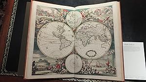
Contact seller5-star sellerHardcover. Folio (21 x 13 4/8 inches). Near contemporary manuscript index leaf listing 147maps. Engraved allegorical title-page for "Atlas Maior", fine double-page engraved map of the world "Planisphaerium Terrestre, sive Terrarum Orbis. Amsterdam ca., 1705 by Carol Allard (Shirley 578, a bit creased), and 146 maps, including 7…folding, numbered in a contemporary hand, ALL COLORED IN A CONTEMPORARY HAND (map of Great Britain with chipping to green coloring due to oxidization, map of Hungary torn along fold, some maps trimmed closely, some light browning and staining, some edges a bit frayed). Original Dutch vellum, panelled in blind (lower hinge split at the head and foot of the spine, a bit soiled, lacking two pairs of ties) Provenance: early ink library stamp of the "Historical Association" on the front paste-down. A fine and comprehensive composite atlas, most published by de Wit but with additional maps by Visscher, Allard, Chatelain and Mortier. In addition to the striking world map by Allard with its black background and numerous projections, and found in the "Atlas Major" from about 1705, there are maps of the continents, regional maps of Europe; and unusually high number of maps of Asia (11) Ottens's "Imperium Japonicum .", Amsterdam, dated 1715, and a fine map of the East Indies showing the northern coastline of Australia; 5 maps of Africa; and 11 maps of the Americas, notably including Carel Allard's "Recentissima Novi Orbis sive Americae Septentrionalis et Meridionalis" Amsterdam, ca. 1700; Visscher's "Nova Tabula Geographica Complectens Borealiorem Americae Partem." Amsterdam, ca. 1690 or later; Visscher's "Carte Nouvelle Contenant la Partie d'Amerique la Plus Septentrionale." Amsterdam, ca. 1685 or later; Ottens' "Totius Neobelgii Nova et Accuratissima Tabula" Amsterdam, ca. 1708 (Burden 373, state 6); Henry Chatelain's "Carte de la Nouvelle France, ou se Voit le Cours des Grandes Rivieres de S. Laurens & de Mississipi . de la Floride, de la Louisiane, de la Virginie, de la Marie-Lande, de la Pensilvanie, du Nouveau Jersay, de la Nouvelle Yorck . " (no date). De Wit was born in Gouda in 1630 became one of the "most famous engravers of maps of the second half of the 17th-century" (Koeman), his earliest maps issued in 1654. In addition to being geographically correct, de Wit's maps are full of detail and are often decorated with elaborate cartouches. "Frederick de Wit, who was the sole proprietor of the firm, was not just a conveyor of maps but also an innovator in the field of commercial cartography. His maps and in particular his atlas production changed the form in which atlases were consumed in the second half of the seventeenth century. de Wit produced and successfully marketed the first concise reference atlas. de Wit's cartographic production is one of the key factors that joined the early Netherlands period in cartography ca 1550 to ca. 1675, to the latter years of Dutch commercial cartography, and European atlas production in the eighteenth century" (George Carhart).
 More images
Published by Amsterdam: F. de Wit, 1690. 1690
- Hardcover
- Signed
Seller: Arader Galleries - AraderNYC, New York, NY, U.S.A.Arader Galleries - AraderNYC
Contact seller5-star sellerCondition: Used - Very good
US$ 78,000.00
Free ShippingShips within U.S.A.Quantity: 1 available
Hardcover. Condition: Very Good. WIT, Frederick de (1630-1706). Orbis Maritimus ofte Zee. Amsterdam: F. de Wit, 1690. Folio (21 x 12 4/8 inches). Engraved allegorical title-page showing the globe surmounted by the figure of Atlas with printed index listing 27 subjects on verso, 27 double-page engraved charts, and 1 fold-out map,… all with FINE CONTEMPORARY HAND COLOR (occasional light offsetting). 19th-century calf antique with blind floral tooled borders (re-backed, repair on front hinge). Provenance: engraved armorial bookplate of Baron de Launoit on the front free endpaper; Christopher Henry Beaumont Pease, Lord Wardington (1924-2005), Library of Important Atlases and Geographies, Sotheby's 10th October 2006, lot 541. A late issue of this remarkable sea atlas. A dramatic image of Atlas pressed against the ceiling of a star filled sky, perched at the top of a globe depicting Europe, Asia, and Africa (with the western edge of Australia unidentified in the lower right) opens this incredible atlas. All maps very clear with coloring still bright and vibrant, particularly the large fold-out map of Europe and North Africa. Pages turn as if they were bound yesterday with maps that lay flat, making this a wonderful presentation copy. More than a collection of detailed maps of every known corner of the Earth, his work serves as a world tour in the form of the fanciful and imaginative cartouches and map embellishments that illustrate this impressive atlas. A wonderful polar projection is enrobed in scenes of whalers killing and processing what look like giant trout, and a particularly jarring scene accompanying the map of Russia depicts a bear hunt in the wild. While most of the map details draw on the work of earlier cartographers, for this edition deWit draws on his substantial skills as a realiser of scenes from the vast Unknown to tickle the imaginations of readers safe at home. Truly the Hieronymus Bosch of Atlas illustration. "It's an amazingly attractive sea atlas and, unlike Goos, Doncker, Robijn, Van Keulen etc., it seems to have been continuously revised and updated. I have since added a copy of the last (third) state of de Wit's chart of the Channel which shows the coastline of France and the Channel Islands re-engraved" (Lord Wardington). Koeman IV, Wit I; Phillips 485. Signed by Author(s).
Condition: Used - Good
US$ 326.73
US$ 57.68 shippingShips from Spain to U.S.A.Quantity: 1 available
Condition: ACEPTABLE. Edición de Pieter van der Aa para la Galerie Agreable du Monde. Formato (cm): 25x29.

Published by c. 1700, Amsterdam 1700
- Art Print
Seller: Frame, Madrid, M, SpainFrame
Contact seller5-star sellerCondition: Used - Good
US$ 392.08
US$ 57.68 shippingShips from Spain to U.S.A.Quantity: 1 available
Condition: ACEPTABLE. Formato (cm): 20x28.
Published by c. 1700, Amsterdam 1700
- Art Print
Seller: Frame, Madrid, M, SpainFrame
Contact seller5-star sellerCondition: Used - Good
US$ 392.08
US$ 57.68 shippingShips from Spain to U.S.A.Quantity: 1 available
Condition: ACEPTABLE. Formato (cm): 20x28.
 More images
Published by Amsterdam, F. de Wit, [c.]. 1680
- Art Print
Seller: Inanna Rare Books Ltd., Skibbereen, CORK, IrelandInanna Rare Books Ltd.
Contact seller5-star sellerCondition: Used
US$ 469.31
US$ 32.30 shippingShips from Ireland to U.S.A.Quantity: 1 available
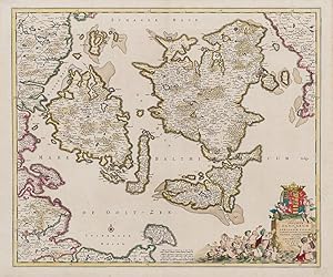
Original hand-coloured engraving. Plate Size: 58.1 cm x 48.8 cm. Sheet Size: 63.8 cm x 53 cm. Original map. In very good condition with only the slightest hints of browning to outer margns only. This beautifully engraved chart shows the main Danish islands of Funen and Zealand plus the eastern coastline of the Jutland peninsula…and a little of southern Sweden. The major Danish cities like Copenhagen, Aarhus and Odense are shown on the map. The map is filled with minute detail of fortresses, cities, towns and tiny villages. Relief depicted pictorially The lower right corner of the map bears a stunningly decorative cartouche featuring the Danish royal coat-of-arms and a Classical scene of putti and merfolk frolicking in the sea with the god Mercury in the foreground. A small compass rose lies off the Schleswig Holstein coast in the Colberger Heide. Frederick de Wit (1629/1630 1706) was a Dutch cartographer and artist who drew, printed and sold maps. By 1648, during the height of the Dutch Golden Age, De Wit had moved from Gouda to Amsterdam. As early as 1654 he had opened a printing office and shop under the name "De Drie Crabben" (the Three Crabs) which was also the name of his house on the Kalverstraat. In 1655, De Wit changed the name of his shop to the "Witte Pascaert" (the White Chart). Under this name De Wit and his firm became internationally known. The first cartographic images that De Wit engraved were a plan of Haarlem that has been dated to 1648. The first charts engraved by De Wit were published in 1654 under the "De Drie Crabben" address. The first map that was both engraved and dated by De Wit was that of Denmark: "REGNI DANIÆ Accuratissima delineatio Perfeckte Kaerte van 't CONJNCKRYCK DENEMARCKEN" in 1659. His first world maps, "NOVA TOTIUS TERRARUM ORBIS TABULA AUCTORE F. DE WIT" and Nova Totius Terrarum Orbis Tabula appeared around 1660. His Atlas began to appear around 1662 and by 1671 included anywhere from 17 to 151 maps each. In the 1690s he began to use a new title page "Atlas Maior" but continued to use his old title page. His atlas of the Low Countries first published in 1667, was named Nieuw Kaertboeck van de XVII Nederlandse Provinciën and contained 14 to 25 maps. De Wit quickly expanded upon his first small folio atlas which contained mostly maps printed from plates that he had acquired, to an atlas with 27 maps engraved by or for him. By 1671 he was publishing a large folio atlas with as many as 100 maps. After Frederick de Wit's death in 1706 his wife Maria continued the business for four years printing and editing De Wit's maps until 1710. However, as De Wit's son Franciscus was already a prosperous merchant by this time and had little interest in his father's business, he did not take over the publishing house. In 1710 Maria sold the firm at auction. At the auction most of the atlas plates and some of the wall map were sold to Pieter Mortier, whose publishing company grew to become one of the largest cartography publishing houses of the 18th century. The 27 chart plates from his 1675 Sea atlas were sold at the 1710 auction, to the Amsterdam print seller Luis Renard, who published them under his own name in 1715, and then sold them to Rennier and Joshua Ottens who continued to publish them until the mid-1700s. (Wikipedia).

Published by Amsterdam s.d. (1710 ca.) 1710
- Map
Seller: Libreria Ex Libris ALAI-ILAB/LILA member, Roma, RM, ItalyLibreria Ex Libris ALAI-ILAB/LILA member
Contact seller5-star sellerCondition: Used
US$ 475.25
US$ 34.61 shippingShips from Italy to U.S.A.Quantity: 1 available
Carta geografica originale (cm. 59x49,5 più margini bianchi) edita da P. Mortier (1661-1711). Splendida coloritura d'epoca all'acquarello. Marigini laterali esigui, altrimenti esemplare in ottimo stato di conservazione. Rara tiratura.

Published by Amsterdam s.d. (1710 ca.) 1710
- Map
Seller: Libreria Ex Libris ALAI-ILAB/LILA member, Roma, RM, ItalyLibreria Ex Libris ALAI-ILAB/LILA member
Contact seller5-star sellerCondition: Used
US$ 534.65
US$ 34.61 shippingShips from Italy to U.S.A.Quantity: 1 available
Carta geografica originale (cm. 58x51 più margini bianchi) edita da P. Mortier (1661-1711). Splendida coloritura d'epoca all'acquarello. Esemplare in ottimo stato di conservazione. Rara tiratura.

Published by Amsterdam s.d. (1710 ca.) 1710
- Map
Seller: Libreria Ex Libris ALAI-ILAB/LILA member, Roma, RM, ItalyLibreria Ex Libris ALAI-ILAB/LILA member
Contact seller5-star sellerCondition: Used
US$ 534.65
US$ 34.61 shippingShips from Italy to U.S.A.Quantity: 1 available
Carta geografica originale (cm. 55x47,5 più ampi margini bianchi) edita da P. Mortier (1661-1711). Splendida coloritura d'epoca all'acquarello. Lievi imperfezioni lungo la piega centrale, altrimenti esemplare in ottimo stato di conservazione. Rara tiratura.

Published by Amsterdam s.d. (1710 ca.) 1710
- Map
Seller: Libreria Ex Libris ALAI-ILAB/LILA member, Roma, RM, ItalyLibreria Ex Libris ALAI-ILAB/LILA member
Contact seller5-star sellerCondition: Used
US$ 534.65
US$ 34.61 shippingShips from Italy to U.S.A.Quantity: 1 available
Carta geografica originale (cm. 58x49 più margini bianchi) edita da P. Mortier (1661-1711). Splendida coloritura d'epoca all'acquarello. Esemplare in ottimo stato di conservazione. Rara tiratura.
Published by Amsterdam 1690 ca. 1690
- Map
Seller: Libreria Ex Libris ALAI-ILAB/LILA member, Roma, RM, ItalyLibreria Ex Libris ALAI-ILAB/LILA member
Contact seller5-star sellerCondition: Used
US$ 534.65
US$ 34.61 shippingShips from Italy to U.S.A.Quantity: 1 available
Incisione originale su rame (cm. 59x50,5 più margini). Splendida coloritura coeva all'acquerello. Carta controfondata e con alcuni piccoli restauri lungo la piegatura centrale. Buon esemplare.

Published by c.1690, Amsterdam 1690
- Art Print
Seller: Frame, Madrid, M, SpainFrame
Contact seller5-star sellerCondition: Used - Good
US$ 653.47
US$ 57.68 shippingShips from Spain to U.S.A.Quantity: 1 available
Condition: ACEPTABLE. [Un] Mapa representando la zona noroeste de la Península Ibérica, abarcando Galicia, el norte del actual Portugal, Parte de Castilla y León, Asturias, Cantabria y País Vasco, y por el sur hasta Madrid y Toledo. Obra de Frederik de Wit (c.1630-1706), un destacado cartógrafo y editor belga activo en Amsterdam… durante el Siglo de Oro Neerlandés. En 1648, de Wit se trasladó a Ámsterdam, donde se convertiría en uno de los grabadores de mapas más famosos de la segunda mitad del siglo XVII. En 1654 abrió una tienda de impresión llamada De Drie Crabben ("los Tres Cangrejos") y, al año siguiente, renombró el negocio con el nombre Witte Pascaert ("la Carta Blanca"), bajo el cual alcanzó fama internacional. De Wit residió y trabajó en Ámsterdam desde 1648 hasta su muerte en 1706. Su obra se destacó por la calidad y precisión de sus mapas, contribuyendo significativamente al comercio y la navegación de la época. Publicó varios atlas mundiales, un atlas marítimo y un atlas de los Países Bajos. La datación de sus mapas es compleja. Sin embargo, dado que se le otorgó un privilegio en 1689, la anotación 'cum privilegio' indica una edición posterior a 1688. Alrededor del año 1700, De Wit entró en el mercado con un atlas de ciudades. Produjo dos volúmenes con un total de 260 planos y vistas; la mayoría fueron impresos a partir de planchas utilizadas anteriormente para los atlas de ciudades de Janssonius y Blaeu. Tras su muerte, su mujer María Van Der Way continuó el negocio por cuatro años imprimiendo y editando los mapas de De Wit hasta 1710, fecha en que vendió la empresa y las planchas pasaron a manos de Pieter Mortier (1661-1711). ["Accuratissima Descriptio Per F. de Wit, Amstelodami ; Amstelodami ex officina Frederici de Wit cum Gratia et Privilegio Potentiss DD Ordinum Hollandie et Westfrisie."] . Formato (cm): 54x63.
Published by Amsterdam 1680
- Map
Seller: Alexandre Antique Prints, Maps & Books, Toronto, ON, CanadaAlexandre Antique Prints, Maps & Books
Contact seller4-star sellerCondition: Used
US$ 675.00
US$ 6.00 shippingShips from Canada to U.S.A.Quantity: 1 available
A beautiful and detailed map of Portugal, with decorative cartouches; by renowned Dutch cartographer Frederick de Wit (1630-1706)., Size : 595x494 (mm), 23.43x19.45 (Inches), Original Hand Coloring Very Good, backed on acid free tissue paper for long term preservation.
Published by Amsterdam: 1671. 1671
Seller: Arader Galleries - AraderNYC, New York, NY, U.S.A.Arader Galleries - AraderNYC
Contact seller5-star sellerSingle sheet (22 ¼ x 19 ½) Full margins showing the plate mark. (light foxing & browning along margin, light offsetting). A rare road map showing the routes for travelers and merchants from the north of Italy to Bohemia, the Netherlands, and east France, across Germany and Switzerland. The map further embraces the area of the Al…ps, north Italy, Tyrol, Bavaria and south Germany, and parts of Slovenia and Istria. The title cartouche features two peasants, one standing on solid ground, the other atop two parcels. This map is taken from Vissher's compiled Atlas Minor siue Geographia Compendiosa, Qua Orbis Terrarum, per paucas attamen novissimas tabulas ostenditu. This map is in excellent condition. It features full margins, original hand coloring, light browning of the edges, and slight foxing. Verso exhibits some oxidation of the ink. The route depicted here is one of the main routes used for trade in the 17th century. This Atlas acted as a guide for those involved in the various guilds, between wool, paper, ink, silver, etc. Each of the routes here held a different significance for every merchant reading the map. The key in the upper margin lists the distances. The map was published by a Dutch cartographer Frederick de Wit (1629/1630 - 1706), however it was made on commission by merchants of Bregenz, Austria. This city, known as a major trading center since the times of antiquity, is shown here in the center of the map. The unusual orientation of the map is intentional in order to fit in all the routes between the north of Italy and the Netherlands. This map is a very rare find in the market. It was frequently published individually and sometimes included in composite atlases. Such was the case with this map. It was a part of composite Visscher atlas. The Atlas Minor is a fine and comprehensive composite atlas, and one of a series of large atlases compiled and sold by the Visscher family of art dealers and cartographers in the 17th century. Founded by Nicholas Visscher, this work is known for the high quality of engraving, exceptionally fine ornament, and accurate geographical information. No two of the Visscher atlases seem to have been identical in content, and most contain, like this one, a selection of maps by the Visschers themselves as well as other cartographers. In this case the majority of the maps are published by Visscher. In addition to the striking world map by Allard with its black background and numerous projections, and found in the "Atlas Major" from about 1705, there are maps of the continents, regional maps of Europe, ten maps of Asia, and seven maps related to America. For more information on this map, or a warm welcome to see other maps and books of our collection at 72nd Street NYC, please contact Natalie Zadrozna.
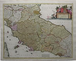
Status Ecclesiasticus et Magnus Ducatus Thoscanae.
DE WIT, Frederick (c. 1630-1706) after Cornelis Danckerts (1603-1656).
Published by Amsterdam: Frederick De Wit, c. 1705. 1705
Seller: Arader Galleries - AraderNYC, New York, NY, U.S.A.Arader Galleries - AraderNYC
Contact seller5-star sellerSingle sheet, (21 x 24 ½ inches). Fine engraved map of central Italy, surrounded by a border of yellow wash, with EXTREMELY FINE ORIGINAL HAND COLOR IN FULL, HEIGHTENED IN LIQUID GOLD, the individual territories shown in different bold watercolors of yellow, green, and pink, the title within an ELABORATE HISTORIATED CARTOUCHE, a…nd decorated with a fine compass rose pointing north with a GOLD-ENHANCED FLEUR-DE-LIS (old central fold, slightly toned). Beautifully engraved map of central Italy, with original hand color in full and SUMPTUOUS GOLD HIGHLIGHTS. The elegant title cartouche shows two royal figures beside two coats-of-arms with a depiction of the Emperor Constantine at center, and a merman in the blue water below bearing a banner, with two putti looking on. The lovely compass rose is colored red and green with a fleur-de-lis ENHANCED WITH LIQUID GOLD indicating north. The map's title translates to "Papal States and the Grand Duchy of Tuscany." In addition to these, the map shows the Duchy of Ferrara, the island of Elba, and part of Corsica. The Papal States were among the major historical states of Italy from roughly the 6th century until the Italian peninsula was unified in 1861. They saw their greatest extent in the 18th century, when they included most of Central Italy - Lazio, Umbria, Marche, and the Legations of Ravenna, Ferrara, and Bologna extending north into the Romagna. The Grand Duchy of Tuscany was a monarchy in central Italy that replaced the Duchy of Florence in 1569 and ruled for almost 300 years, until 1859. At the time this map was created, Cosimo III de' Medici was the Grand Duke of Tuscany, whose 53-year reign - the longest in Tuscan history - saw much upheaval and decline in the Duchy. De' Medici passed stringent morality laws taxing prostitutes and beheading sodomites, and he censored education and suppressed the Jewish minority. In response to a steep decline in population, he raised taxes exponentially to make up the difference; nevertheless, by 1705 the grand ducal treasury was nearly bankrupt, and the population had dwindled by 40%. The map is extremely detailed, showing the road that leads from Piacenza to Rimini on the Gulf of Venice. The topographical features are rendered pictorially, with the larger cities depicted as fortified citadels.

Published by Amsterdam 1680
- Map
Seller: Alexandre Antique Prints, Maps & Books, Toronto, ON, CanadaAlexandre Antique Prints, Maps & Books
Contact seller4-star sellerCondition: Used - Very good
US$ 700.00
US$ 6.00 shippingShips from Canada to U.S.A.Quantity: 1 available
Condition: Very Good. Detailed and decorative map of Holland by famous Dutch cartographer Frederick de Wit., Size : 455x555 (mm), 17.875x21.875 (Inches), Original Hand Coloring.

Published by Amsterdam 1680
- Map
Seller: Alexandre Antique Prints, Maps & Books, Toronto, ON, CanadaAlexandre Antique Prints, Maps & Books
Contact seller4-star sellerCondition: Used - Very good
US$ 675.00
US$ 6.00 shippingShips from Canada to U.S.A.Quantity: 1 available
Condition: Very Good. Detailed map of Bohemia, Silesia, Moravia and Lusatia by renowned Dutch cartographer Frederick de Wit (1630-1706)., Size : 480x570 (mm), 18.875x22.375 (Inches), Original Hand Coloring.

Published by Amsterdam 1680
- Map
Seller: Alexandre Antique Prints, Maps & Books, Toronto, ON, CanadaAlexandre Antique Prints, Maps & Books
Contact seller4-star sellerCondition: Used
US$ 700.00
US$ 6.00 shippingShips from Canada to U.S.A.Quantity: 1 available
Decorative and detailed map of seventeen provinces of the Low Countries.The map shows both the Netherlands and Belgium with two large decorative cartouches. , Size : 475x555 (mm), 18.75x21.875 (Inches), Original Hand Coloring Very Good, laid on acid free tissue paper for long term preservation. Some browning due to the colour tr…ansfer of the image on the opposite page while in the atlas.
Published by c.1697, Amsterdam 1697
- Map
Seller: Alexandre Antique Prints, Maps & Books, Toronto, ON, CanadaAlexandre Antique Prints, Maps & Books
Contact seller4-star sellerCondition: Used - Very good
US$ 1,000.00
US$ 6.00 shippingShips from Canada to U.S.A.Quantity: 1 available
Condition: Very Good. A detailed and decorative map of the Americas, with an elaborate cartouche. Eighth state.The map shows California as an island, the Great Lakes are open-ended in the west, and the R. del Norte flows from a large western lake and empties into the sea between the mainland and California, labeled Mare Vermio.…In South America, the mythical lakes of Parime Lacus and Xarayes are shown, along with vignettes of a battle scene and a village in the Brazilian interior. , Size : 494x590 (mm), 19.45x23.23 (Inches), Original Hand Coloring, 0.

Published by Amsterdam s.d. (1710 ca.) 1710
- Map
Seller: Libreria Ex Libris ALAI-ILAB/LILA member, Roma, RM, ItalyLibreria Ex Libris ALAI-ILAB/LILA member
Contact seller5-star sellerCondition: Used
US$ 891.09
US$ 34.61 shippingShips from Italy to U.S.A.Quantity: 1 available
Carta geografica originale (cm. 55,5x44,5 più ampi margini bianchi) edita da P. Mortier (1661-1711). Splendida coloritura d'epoca all'acquarello. Esemplare in ottimo stato di conservazione. Rara tiratura.

Published by Amsterdam s.d. (1710 ca.) 1710
- Map
Seller: Libreria Ex Libris ALAI-ILAB/LILA member, Roma, RM, ItalyLibreria Ex Libris ALAI-ILAB/LILA member
Contact seller5-star sellerCondition: Used
US$ 772.28
US$ 34.61 shippingShips from Italy to U.S.A.Quantity: 1 available
Carta geografica originale (cm. 58x49 più margini bianchi) edita da P. Mortier (1661-1711). Splendida coloritura d'epoca all'acquarello. Minime imperfezioni lungo la piega centrale, altrimenti esemplare in ottimo stato di conservazione. Rara tiratura.

Published by Amsterdam s.d. (1710 ca.) 1710
- Map
Seller: Libreria Ex Libris ALAI-ILAB/LILA member, Roma, RM, ItalyLibreria Ex Libris ALAI-ILAB/LILA member
Contact seller5-star sellerCondition: Used
US$ 831.68
US$ 34.61 shippingShips from Italy to U.S.A.Quantity: 1 available
Carta geografica originale (cm. 55x45,5 più ampi margini bianchi) edita da P. Mortier (1661-1711). Splendida coloritura d'epoca all'acquarello. Esemplare in ottimo stato di conservazione. Rara tiratura.

Published by Amsterdam s.d. (1710 ca.) 1710
- Map
Seller: Libreria Ex Libris ALAI-ILAB/LILA member, Roma, RM, ItalyLibreria Ex Libris ALAI-ILAB/LILA member
Contact seller5-star sellerCondition: Used
US$ 772.28
US$ 34.61 shippingShips from Italy to U.S.A.Quantity: 1 available
Carta geografica originale (cm. 58x50 più margini bianchi) edita da P. Mortier (1661-1711). Splendida coloritura d'epoca all'acquarello. Esemplare in ottimo stato di conservazione. Rara tiratura.

Published by Amsterdam s.d. (1710 ca.) 1710
- Map
Seller: Libreria Ex Libris ALAI-ILAB/LILA member, Roma, RM, ItalyLibreria Ex Libris ALAI-ILAB/LILA member
Contact seller5-star sellerCondition: Used
US$ 831.68
US$ 34.61 shippingShips from Italy to U.S.A.Quantity: 1 available
Carta geografica originale (cm. 57x49 più margini bianchi) edita da P. Mortier (1661-1711). Splendida coloritura d'epoca all'acquarello. Alcune macchioline e lieve imperfezione lungo la piega centralre, altrimenti esemplare in ottimo stato di conservazione. Rara tiratura. Cfr. Borri, n. 122.

Published by Amsterdam s.d. (1710 ca.) 1710
- Map
Seller: Libreria Ex Libris ALAI-ILAB/LILA member, Roma, RM, ItalyLibreria Ex Libris ALAI-ILAB/LILA member
Contact seller5-star sellerCondition: Used
US$ 891.09
US$ 34.61 shippingShips from Italy to U.S.A.Quantity: 1 available
Carta geografica originale (cm. 49,5x58,5 più margini bianchi) edita da P. Mortier (1661-1711). Splendida coloritura d'epoca all'acquarello. Margini superiore ed inferiore esigui, peraltro esemplare in ottimo stato di conservazione. Rara tiratura.

Published by Amsterdam s.d. (1710 ca.) 1710
- Map
Seller: Libreria Ex Libris ALAI-ILAB/LILA member, Roma, RM, ItalyLibreria Ex Libris ALAI-ILAB/LILA member
Contact seller5-star sellerCondition: Used
US$ 831.68
US$ 34.61 shippingShips from Italy to U.S.A.Quantity: 1 available
Carta geografica originale (cm. 52,5x43,5 più ampi margini bianchi) edita da P. Mortier (1661-1711). Splendida coloritura d'epoca all'acquarello. Due macchioline marginali che toccano in minima parte l'incisione, peraltro esemplare in ottimo stato di conservazione. Rara tiratura.

Published by Amsterdam s.d. (1710 ca.) 1710
- Map
Seller: Libreria Ex Libris ALAI-ILAB/LILA member, Roma, RM, ItalyLibreria Ex Libris ALAI-ILAB/LILA member
Contact seller5-star sellerCondition: Used
US$ 712.87
US$ 34.61 shippingShips from Italy to U.S.A.Quantity: 1 available
Carta geografica originale (cm. 58x50 più margini bianchi) edita da P. Mortier (1661-1711). Splendida coloritura d'epoca all'acquarello. Esemplare in ottimo stato di conservazione. Rara tiratura.

Published by Amsterdam s.d. (1710 ca.) 1710
- Map
Seller: Libreria Ex Libris ALAI-ILAB/LILA member, Roma, RM, ItalyLibreria Ex Libris ALAI-ILAB/LILA member
Contact seller5-star sellerCondition: Used
US$ 1,188.12
US$ 34.61 shippingShips from Italy to U.S.A.Quantity: 1 available
Carta geografica originale (cm. 58x49 più margini bianchi) edita da P. Mortier (1661-1711). Splendida coloritura d'epoca all'acquarello. Alcuni minimi antichi restauri, altrimenti esemplare in ottimo stato di conservazione. Rara tiratura.

Published by Amsterdam s.d. (1710 ca.) 1710
- Map
Seller: Libreria Ex Libris ALAI-ILAB/LILA member, Roma, RM, ItalyLibreria Ex Libris ALAI-ILAB/LILA member
Contact seller5-star sellerCondition: Used
US$ 1,009.90
US$ 34.61 shippingShips from Italy to U.S.A.Quantity: 1 available
Carta geografica originale (cm. 57x49 più margini bianchi) edita da P. Mortier (1661-1711). Splendida coloritura d'epoca all'acquarello. Due minuscoli forellini nella parte incisa, altrimenti esemplare in ottimo stato di conservazione. Rara tiratura.

Published by Amsterdam s.d. (1710 ca.) 1710
- Map
Seller: Libreria Ex Libris ALAI-ILAB/LILA member, Roma, RM, ItalyLibreria Ex Libris ALAI-ILAB/LILA member
Contact seller5-star sellerCondition: Used
US$ 772.28
US$ 34.61 shippingShips from Italy to U.S.A.Quantity: 1 available
Carta geografica originale (cm. 58x50 più margini bianchi) edita da P. Mortier (1661-1711). Splendida coloritura d'epoca all'acquarello. Esemplare in ottimo stato di conservazione. Rara tiratura.


