Order Total (1 Item Items):
Shipping Destination:

General Drafting Company (33 results)
Skip to main search results
Search filters
Product Type
- All Product Types
- Books (31)
- Magazines & Periodicals (No further results match this refinement)
- Comics (No further results match this refinement)
- Sheet Music (No further results match this refinement)
- Art, Prints & Posters (No further results match this refinement)
- Photographs (No further results match this refinement)
- Maps (2)
- Manuscripts & Paper Collectibles (No further results match this refinement)
Condition Learn more
Binding
Collectible Attributes
- First Edition (No further results match this refinement)
- Signed (No further results match this refinement)
- Dust Jacket (No further results match this refinement)
- Seller-Supplied Images (25)
- Not Print on Demand (26)
Language (2)
Free Shipping
Seller Location
Seller Rating
-
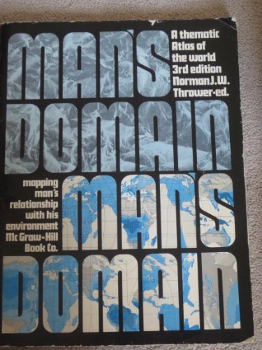
Man's domain, a thematic atlas of the world: Mapping man's relationship with his environment
Language: English
Published by McGraw-Hill Book Co (edition 3rd), 1975
ISBN 10: 0070230838 ISBN 13: 9780070230835
Paperback. Condition: Fair. 3rd. The item might be beaten up but readable. May contain markings or highlighting, as well as stains, bent corners, or any other major defect, but the text is not obscured in any way.
-
Condition: Acceptable. COVER SHOWS WEAR. OTHERWISE IN GOOD CONDITION A readable copy. All pages are intact, and the cover is intact (However the dust cover may be missing). Pages can include considerable notes--in pen or highlighter--but the notes cannot obscure the text. Book may be a price cutter or have a remainder mark.
-
Man's domain, a thematic atlas of the world: Mapping man's relationship with his environment
Language: English
Published by McGraw-Hill Book Co, New York, 1975
ISBN 10: 0070230838 ISBN 13: 9780070230835
Seller: Manning's Books & Prints, ABAA, Pacifica, CA, U.S.A.
Seller rating 4 out of 5 stars

Soft cover. Condition: Good. 3rd Edition. The Book Is In Good Condition, Pages & Binding Are Clean And Tight,
-

Two 1951 road maps. {#1} OFFICIAL HIGHWAY MAP OF MISSISSIPPI. COMPLEMENTS STATE HIGHWAY DEPARTMENT and {#2} STANDARD OIL. MISSISSIPPI ARKANSAS LOUISIANA ROAD MAP WITH PICTORIAL GUIDE.
Published by Jackson, MS: Traffic & Planning Division for State Highway Commission [Mississippi State Highway Department - Mississippi Department of Transportation], July 1951. [Louisville, KY] - New York: Standard Oil Company (Kentucky) - General Drafting Co., Inc., 1951., 1951
Seller: David Hallinan, Bookseller, Columbus, MS, U.S.A.
Seller rating 5 out of 5 stars

{ITEM #1.} OFFICIAL HIGHWAY MAP OF MISSISSIPPI. COMPLEMENTS STATE HIGHWAY DEPARTMENT (with map legend title as "Official Road Map. State of Mississippi. Fielding L. Wright, Governor . . . "). Jackson, MS: Traffic & Planning Division for State Highway Commission, July 1951. Double-sided foldout color road map of Mississippi. Total of 8 panels per side. Approximate unfolded dimensions: H 17 inches x L 22 inches. Light toning and light creasing to exterior rear panel; a few edge nicks and negligibly small chips. Full-length color state map on verso primarily printed in white, black, and blue with extensive border area in pink with small inset maps for major towns. Map shows major state highways as paved or gravel (i.e. unpaved) as well as county borders, cities, towns, etc. Map title provides date of July 1951. Recto side features color photographs of state industry, agriculture, tourism-related, etc. with brief captions. {ITEM #2.} STANDARD OIL. MISSISSIPPI ARKANSAS LOUISIANA ROAD MAP WITH PICTORIAL GUIDE. [Louisville, KY] - New York: Standard Oil Company (Kentucky) - General Drafting Co., Inc., 1951. Double-sided foldout color road map. Total of 15 panels per side. Approximate unfolded dimensions: H 26 inches x L 19.25 inches. Library stamp on rear cover panel and short crease at bottom left corner. Full color highway map of the tri-state region on verso. Recto has mileage chart, town index, a "Pictorial Guide to Mississippi" map, and general maps for New Orleans, Natchez, Jackson, Vicksburg, and Memphis.
-
hardcover. Condition: Good. No Highlighting or writing. Some Wear but overall good condition. 100% Satisfaction Guaranteed.
-

Condition: Good. 2nd. Pages intact with minimal writing/highlighting. The binding may be loose and creased. Dust jackets/supplements are not included. Stock photo provided. Product includes identifying sticker. Better World Books: Buy Books. Do Good.
-
paperback. Condition: Good. Tape repair along outer spine and hinges. Rubmarks/minor chipping on edges of covers. Book shows common (average) signs of wear and use. Binding is still tight. Covers are intact but may be repaired. We have 75,000 books to choose from -- Ship within 24 hours -- Satisfaction Guaranteed!
-
Man's domain, a thematic atlas of the world: Mapping man's relationship with his environment
Language: English
Published by Brand: McGraw-Hill Inc.,US, 1975
ISBN 10: 0070230838 ISBN 13: 9780070230835
Condition: new.
-
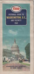
ESSO pictorial guide of Washington, D.C., and vicinity : our nation's capital
Published by Standard Oil Co., New York?, 1942
Map
No Binding. Condition: Very Good. folding map,2 maps on 1 sheet : both sides, color ; 47 x 63 cm and 47 x 41 cm, sheet 50 x 66 cm, folded to 25 x 11 cm separation at 2 folds, some over all soil, Esso pictorial map of Washington, our nation's capital Happy motoring in Washington and vicinity Selected buildings shown pictorially on city map Panel title "Copyright, General Drafting Co., Inc." Includes text, indexes to points of interest, Alexandria inset, sector diagram, col. ill., and advertisement POSTAGE WILL BE REDUCED. Map.
-
![Seller image for Markets of the world; a series of economic maps & statistical abstracts of the principal countries of the world . comp. by General drafting co., inc. 1920 [LeatherBound] for sale by S N Books World](https://pictures.abebooks.com/inventory/md/md31376382995.jpg)
LeatherBound. Condition: New. BOOKS ARE EXEMPT FROM IMPORT DUTIES AND TARIFFS; NO EXTRA CHARGES APPLY. Leatherbound edition. Condition: New. Leather Binding on Spine and Corners with Golden leaf printing on spine. Bound in genuine leather with Satin ribbon page markers and Spine with raised gilt bands. Pages: 58. A perfect gift for your loved ones. Reprinted from 1920 edition. NO changes have been made to the original text. This is NOT a retyped or an ocr'd reprint. Illustrations, Index, if any, are included in black and white. Each page is checked manually before printing. As this print on demand book is reprinted from a very old book, there could be some missing or flawed pages, but we always try to make the book as complete as possible. Fold-outs, if any, are not part of the book. If the original book was published in multiple volumes then this reprint is of only one volume, not the whole set. IF YOU WISH TO ORDER PARTICULAR VOLUME OR ALL THE VOLUMES YOU CAN CONTACT US. Resized as per current standards. Sewing binding for longer life, where the book block is actually sewn (smythe sewn/section sewn) with thread before binding which results in a more durable type of binding. Language: English Pages: 58.
-
![Seller image for Of maps and mapping 1959 [LeatherBound] for sale by S N Books World](https://pictures.abebooks.com/inventory/md/md30863607877.jpg)
Of maps and mapping 1959 [LeatherBound]
Language: English
Publication Date: 2025
Leatherbound. Condition: NEW. BOOKS ARE EXEMPT FROM IMPORT DUTIES AND TARIFFS; NO EXTRA CHARGES APPLY. Leatherbound edition. Condition: New. Leather Binding on Spine and Corners with Golden leaf printing on spine. Bound in genuine leather with Satin ribbon page markers and Spine with raised gilt bands. Pages: 64. A perfect gift for your loved ones. Reprinted from 1959 edition. NO changes have been made to the original text. This is NOT a retyped or an ocr'd reprint. Illustrations, Index, if any, are included in black and white. Each page is checked manually before printing. As this print on demand book is reprinted from a very old book, there could be some missing or flawed pages, but we always try to make the book as complete as possible. Fold-outs, if any, are not part of the book. If the original book was published in multiple volumes then this reprint is of only one volume, not the whole set. IF YOU WISH TO ORDER PARTICULAR VOLUME OR ALL THE VOLUMES YOU CAN CONTACT US. Resized as per current standards. Sewing binding for longer life, where the book block is actually sewn (smythe sewn/section sewn) with thread before binding which results in a more durable type of binding. Language: English Pages: 64.
-
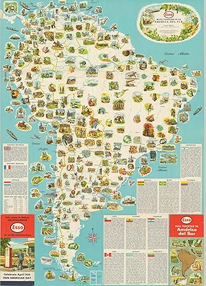
Mapa Panoramico de America Del Sur - Mid-century road map of South America.
Published by c. 1955, 1955
Seller: Curtis Wright Maps, Berwyn, IL, U.S.A.
Seller rating 4 out of 5 stars
Condition: Fine. This Spanish-language map of South America was published around 1955 by the General Drafting Company to promote ESSO oil products and encourage motor tourism across the continent. One side presents a beautiful pictorial map that completely omits national borders. Dozens of vibrantly illustrated vignettes highlight South America's myriad of attractions, historic sites, natural features, and recreational opportunities. A brief description of each country is accompanied by an image of its flag. The verso is a more traditional road map of the continent, with an index of cities and towns and an inset physical map. Sheet Width (in) 24 Sheet Height (in) 33.5 Condition Description Creasing and minor wear along originally issued fold lines, including some light wrinkling and tiny tears along the outer edges of the sheet. Very good to near fine overall.
-
![Seller image for Markets of the world. : A series of economic maps & statistical abstracts of the principal countries of the world. / Compiled and published by the First National Bank of Boston, Mass., U.S.A 1920 [LeatherBound] for sale by S N Books World](https://pictures.abebooks.com/inventory/md/md30638766926.jpg)
Leatherbound. Condition: NEW. BOOKS ARE EXEMPT FROM IMPORT DUTIES AND TARIFFS; NO EXTRA CHARGES APPLY. Leatherbound edition. Condition: New. Leather Binding on Spine and Corners with Golden leaf printing on spine. Bound in genuine leather with Satin ribbon page markers and Spine with raised gilt bands. Pages: 146. A perfect gift for your loved ones. Reprinted from 1920 edition. NO changes have been made to the original text. This is NOT a retyped or an ocr'd reprint. Illustrations, Index, if any, are included in black and white. Each page is checked manually before printing. As this print on demand book is reprinted from a very old book, there could be some missing or flawed pages, but we always try to make the book as complete as possible. Fold-outs, if any, are not part of the book. If the original book was published in multiple volumes then this reprint is of only one volume, not the whole set. IF YOU WISH TO ORDER PARTICULAR VOLUME OR ALL THE VOLUMES YOU CAN CONTACT US. Resized as per current standards. Sewing binding for longer life, where the book block is actually sewn (smythe sewn/section sewn) with thread before binding which results in a more durable type of binding. Language: English Pages: 146.
-
![Seller image for Markets of the world, United States & Canada series; a compilation of commercial maps & statistical data. Prepared and published by the First National Bank of Boston 1922 [LeatherBound] for sale by S N Books World](https://pictures.abebooks.com/inventory/md/md30638764206.jpg)
Leatherbound. Condition: NEW. BOOKS ARE EXEMPT FROM IMPORT DUTIES AND TARIFFS; NO EXTRA CHARGES APPLY. Leatherbound edition. Condition: New. Leather Binding on Spine and Corners with Golden leaf printing on spine. Bound in genuine leather with Satin ribbon page markers and Spine with raised gilt bands. Pages: 82. A perfect gift for your loved ones. Reprinted from 1922 edition. NO changes have been made to the original text. This is NOT a retyped or an ocr'd reprint. Illustrations, Index, if any, are included in black and white. Each page is checked manually before printing. As this print on demand book is reprinted from a very old book, there could be some missing or flawed pages, but we always try to make the book as complete as possible. Fold-outs, if any, are not part of the book. If the original book was published in multiple volumes then this reprint is of only one volume, not the whole set. IF YOU WISH TO ORDER PARTICULAR VOLUME OR ALL THE VOLUMES YOU CAN CONTACT US. Resized as per current standards. Sewing binding for longer life, where the book block is actually sewn (smythe sewn/section sewn) with thread before binding which results in a more durable type of binding. Language: English Pages: 82.
-
Asia, Eastern Europe & Australia Reference & Resource Map
Language: English
Published by Asia, Journal of the American Asiatic Association, New York, 1918
US$ 649.18
US$ 33.17 shipping
Ships from United Kingdom to U.S.A.Quantity: 1 available
Add to basketNo Binding. Condition: Very Good. Colour printed paper map 97x86cm. Very good, neatly folded with closed fold tears. Compiled, engraved and printed by the General Drafting Co. Ltd, New York. Undated, but Worldcat entries generally estimate 1918-19. This is about consistent with the Turkish (Ottoman) border still extending through Mesopotamia to the head of the Persian Gulf. The Journal of the American Asiatic Association ran from 1898-1946. In 1917 it was bought by Willard and Dorothy Straight who prefixed the name with "Asia". Drawing on their experience promoting US trade and investment in Korea and China, it became a vehicle for the Straights to promote US influence across Asia by overcoming "the ignorance of our people" (March 1917 issue). This map was issued with that aim in mind. Centred on the Chinese Republic, coverage is bounded by Scotland (NW), the Gulf of Anadyr (NE), Arapura Sea (SE), and Arabian Sea (SW) on a scale of about 1 inch to 190 miles. Australia is shown in an inset at about 1 inch to 270 miles, with an inset for Tasmania. Details include international and provincial boundaries, 4 classes of settlement, 2 classes of railroad, caravan routes, steamship routes with distances, canals, heads of navigation, and seaports. Symbols are used for 17 types of mineral, agricultural product and fisheries, with several other resources or products named in the image. India for example is shown as widely rich in cattle and teak, with other significant resources including buffalo, sheep, jute, iron, coal and salt. The pre-oil Arabian Peninsula is labelled with pearls on the Persian Gulf and Red Sea coasts (the former naming Sharjah and Ras al Khaimah), dates, camels, horses, myrrh, and frankincense.
-
Southern Cruising Guide - Savannah, Jacksonville, Miami, Key West, Tampa, and Gulf Coast to New Orleans. [Gulf Coast Navigation, Florida Waterways, Illustrated Nautical Chart, Corporate Travel Ephemera]
Seller: Blind-Horse-Books (ABAA), DeLand, FL, U.S.A.
Association Member: ABAA ESA FABA ILAB IOBA
Seller rating 5 out of 5 stars
Map
Condition: Very Good. Cartography by General Drafting Co., New York. (illustrator). The boating map that sold Florida before Disney Large-format illustrated cruising chart produced by Standard Oil during the postwar leisure-boating boom, covering the Intracoastal Waterway and Gulf Coast routes from Savannah through Florida to New Orleans. Designed as both a functional navigation aid and a promotional travel object, the chart blends precise coastal cartography with pictorial lighthouse vignettes and regional landmarks, making it equally appealing to navigators and collectors of mid-century American ephemera. Physical description: Single large double-sided printed sheet, folded as issued, multiple-color offset lithography on thin stock, nautical soundings, route lines, compass roses, lighthouse and harbor illustrations, key map and legend panels, Standard Oil branding and General Drafting imprint present, approximate unfolded size large-format, exact measurements to be supplied. Condition: Paper is clean and supple with light, even age toning, original folds intact, minor handling wear at fold intersections, no losses, no tape repairs, graphics remain sharp and legible throughout, folds remain sound, issued folding format restated. Scarcity note: Surviving examples are increasingly scarce in clean, complete condition, particularly double-sided sheets retaining strong color and intact folds, most examples encountered show heavier fold wear or staining. The Southern Cruising Guide reflects the moment when recreational boating became accessible to middle-class Americans, supported by improved waterways, standardized navigation aids, and the rise of automobile and petroleum-sponsored tourism. General Drafting's crisp cartography is softened by charming illustrative elements that turn functional navigation into visual storytelling. The chart reads as both a working tool and a piece of Americana, merging maritime precision with aspirational travel culture. Historical significance Issued as part of Standard Oil's broader travel and mobility outreach, the chart illustrates how petroleum companies positioned themselves as partners in leisure and exploration, not merely fuel suppliers. It documents the growth of Florida and Gulf Coast boating infrastructure just prior to the massive postwar development boom, making it a valuable artifact for maritime, regional, and advertising history. Subjects: Intracoastal Waterway, Florida Gulf Coast, Recreational boating history, Maritime navigation, Petroleum advertising, Mid-century American design Maps and charts, Printed ephemera, Nautical material Single-sheet, double-sided folding nautical chart.
-

New York to Florida 'Upside-Down Map' - A Novel Aid to Happy Motoring!'
Publication Date: 1955
Seller: Curtis Wright Maps, Berwyn, IL, U.S.A.
Seller rating 4 out of 5 stars
Condition: Fine. " Nearly all road maps point North. But we've found that many travelers turn their maps upside down when going South.So Esso has designed this special map for the increasing number of drivers who go South each season." - Text, center left. This interesting (albeit gimmicky) road map of the Atlantic Coast was published in 1955 by the General Drafting Company on behalf of ESSO Oil. The relatively standard image is flipped upside down to better serve those travelers who head for warmer weather each winter season. Summaries of various locations of interest are printed on the verso." Sheet Width (in) 8.25 Sheet Height (in) 27.75 Condition Description 7 panel folding brochure, printed on both sides. Light wear, consistent with age and use. Near fine condition overall.
-

Pictorial Map of the American Continent featuring the Pan American Highway - Beautiful pictorial map of the Western Hemisphere promoting Pan-American relations (and road trips).
Published by c. 1941, 1941
Seller: Curtis Wright Maps, Berwyn, IL, U.S.A.
Seller rating 4 out of 5 stars
Condition: Very Good. "It's perhaps not surprising that the General Drafting Company, a subsidiary of Standard Oil, would be interested in promoting (and heavily lobbying for) the construction of the Pan American highway. First conceived in 1923, construction by individual countries on their respective portion of the road would not begin until 1937. This map was published a few years later, likely around 1941 or 1942 based on population statistics on the verso. Completed and projected routes are shown in solid and hashed red lines, while numerous vignettes scattered throughout the image illustrate local industries, scenery, influential figures, and landmarks. Accompanying the map is extensive text presenting the Americas as a cohesive entity, unified by miles of pavement and asphalt. " The leading civil engineers of the Americas have conquered equatorial swamps, landslides, burning deserts, and snowy peaks so that someday the motorists of two continents may visit their neighbors swiftly, safely, and in comfort." The threat of global war also likely contributed to these suggested feelings of Pan-American harmony." Sheet Width (in) 18 Sheet Height (in) 24.5 Condition Description Color map/brochure printed on both sides. Scattered spotting along the outer edges of the sheet, concentrated most heavily in the lower corners and upper right margin. Soft creasing along old fold lines (as issued) and light toning on the verso that does not affect the image.
-
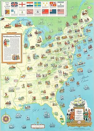
Life in Colonial America - Pictorial map issued in conjunction with the 1957 Jamestown Festival in Virginia.
Publication Date: 1957
Seller: Curtis Wright Maps, Berwyn, IL, U.S.A.
Seller rating 4 out of 5 stars
Condition: Fine. "The " Jamestown Festival" took place over an eighth month period in Virginia during 1957, to celebrate the 350th anniversary of the settlement's founding. This pictorial map was issued to commemorate the event and provides a historical overview of life in colonial America between the original landing at Jamestown and the Revolution. Numerous vignettes accompanied by succinct captions highlight many of the important places, people, and events that led to the formation of the United States in the late 18th century. The various flags of colonial America can be seen at the top of the sheet, while a brief paragraph provides a whitewashed summary of the events that led to the conquest of the continent. The verso shows vivid reproductions of several early important maps of America, including John Smith's map of Virginia, John White's map of North Carolina, and surveys of New York, Philadelphia, Boston, and New Orleans. Published in 1957 by the General Drafting Company on behalf of Esso Oil." Sheet Width (in) 23.9 Sheet Height (in) 33.4 Condition Description Creasing along originally issued fold lines, but otherwise in near fine condition.
-
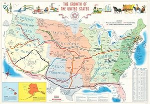
The Growth of the United States - General Drafting Company's map celebrating America's bicentennial.
Publication Date: 1976
Seller: Curtis Wright Maps, Berwyn, IL, U.S.A.
Seller rating 4 out of 5 stars
Condition: Fine. This lovely map of the United States was issued by the General Drafting Company in 1976 to celebrate America's 200th birthday. The image presents the growth of the United States as an iterative process that began with the Revolution and culminated with the annexation of Hawaii and the U.S. Overseas Territories. Bright colors highlight each major acquisition, with the major trails that facilitated Westward Expansion also colored and labeled. Small illustrations throughout the map and across the top reflect the historical development of the nation, especially in terms of its transportation system. The verso presents a pictorial map of America in colonial times, from the earliest European settlers to the outbreak of the Revolution. Sheet Width (in) 33.75 Sheet Height (in) 23.25 Condition Description Creasing along originally issued fold lines, otherwise in fine condition overall.
-

A Pictorial Map of the United States - A visual representation of American postwar prosperity.
Published by c. 1955, 1955
Seller: Curtis Wright Maps, Berwyn, IL, U.S.A.
Seller rating 4 out of 5 stars
Condition: Fine. Designed by the General Drafting Company and published by the Esso (S-O, a company created from the dissolution of Standard Oil) Oil Company in the mid 1950's, this pictorial map highlights the industrial, agricultural, and recreational bounty of the postwar United States. Small, charming illustrations showing all that America has to offer can be found in every state and along every coast. Emphasis and priority is given to regional exports and local financial engines like manufacturing, produce, etc., but numerous prominent landmarks are also featured; blurring the distinction between cultural identity and economic development. Three insets at the bottom of the sheet show oil production, refineries and pipelines across the United States. According to text on the verso, the map was designed to be hung in a classroom and was distributed freely simply by inquiring with Esso's marketing department. By broadly circulating material such as this, a global oil company was able to successfully associate their financial success with the economic well-being of an entire nation! Sheet Width (in) 35.9 Sheet Height (in) 23.9 Condition Description Originally folded into a 24 panel brochure. Creasing along original fold lines and a few pinholes in the outer margins from where the map was previously hung. Otherwise in excellent condition.
-
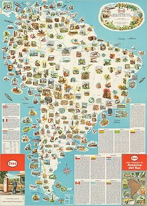
Mapa Panoramico de America del Sur - Double sided map of South America from the mid-20th century.
Publication Date: 1953
Seller: Curtis Wright Maps, Berwyn, IL, U.S.A.
Seller rating 4 out of 5 stars
Condition: Fine. This eye-catching map of South America was published in New Jersey by the General Drafting Company on behalf of Esso Oil. One side presents a stunning pictorial depiction of the continent, highlighting primary industrial exports, agricultural products, historic sites, recreational opportunities, and more. Accompanying text (in Spanish) describes the various countries in some detail. The verso presents a transportation outline of South America as well as a physical map of the continent. The map is emblematic of ongoing efforts by American multi-national corporations to extend operations into foreign markets during the 20th century. Sheet Width (in) 23.75 Sheet Height (in) 33.5 Condition Description Light creasing and faint wear along fold lines, as issued.
-

Pictorial Map of Alaska - Pictorial celebration of Alaska's statehood.
Publication Date: 1959
Seller: Curtis Wright Maps, Berwyn, IL, U.S.A.
Seller rating 4 out of 5 stars
Condition: Fine. "This wonderful pictorial map was issued by the General Drafting Company in 1959 to welcome the 49th of the United States of America. The industries, cultural heritage, and transportation network of Alaska are highlighted with various pictorial icons and colored illustrations. Two inset maps are present. The first (upper right) shows the strategic geographic situation secured with Alaska's statehood, including its connection to the U.S. Interstate System via the Alaska Highway. The second inset (lower center) shows the Aleutian Island chain. The verso features extensive text outlining further the region's history, agriculture, geography, and commercial opportunities. It also presents advertisements for Westinghouse appliances and characters from the popular show 'I Love Lucy." " Sheet Width (in) 20 Sheet Height (in) 16.75 Condition Description Faint creasing along originally issued fold lines and faint wear along the outer edges of the sheet. Very good to fine condition overall.
-
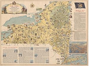
"New York " The Empire State" " - "Postwar pictorial celebration of " The Empire State" "
Published by c. 1946, 1946
Seller: Curtis Wright Maps, Berwyn, IL, U.S.A.
Seller rating 4 out of 5 stars
Condition: Very Good. "This attractive pictorial map of New York was designed by the General Drafting Company and published in Albany by the New York State Department of Commerce in 1946. With the horrors of World War II in the rearview, the map leverages the New York's relatively short (Western) history to highlight its incredible rise to the status of " Empire State." Illustrated vignettes show prominent figures, historic sites, recreational opportunities, industrial products, and notable events. A brief essay in the lower left, written by Dr. Albert B. Corey, provides a timeline of New York history from Henry Hudson into the 1940s, though there is no reference to either WWI or WWII. Additional text in the upper right presents contemporary statistics and facts that would have been very persuasive to individuals and businesses looking to relocate in the postwar years. Source: Rumsey 8987.000" Sheet Width (in) 39.25 Sheet Height (in) 29.5 Condition Description Moderate wear and creasing along former fold lines. Moderate wear along the outer edges of the sheet, most evident in the lower right with a few small tears and chips in the paper. One damp stain in the center-right, just to the left of the NEW YORK STATE INSIGNIA text. Between good and very good overall.
-
Atlantic Road Map Pennsylvania - Delaware [Title on Verso] - " "THERE IS AN ATLANTIC PUMP ON THE ROAD YOU ARE TRAVELING" "
Publication Date: 1927
Seller: Curtis Wright Maps, Berwyn, IL, U.S.A.
Seller rating 4 out of 5 stars
Condition: Very Good. This promotional road map covering the states of Delaware and Pennsylvania was published by the Atlantic Refining Company of Philadelphia and Pittsburgh in 1927. Atlantic was one of the 34 companies established as a result of Standard Oil's Supreme Court-mandated dissolution in 1911 and would eventually merge with Richfield Oil to become ARCO. Four different maps across the recto and verso were designed by the General Drafting Companies and show 1. Road Map of Pennsylvania, 2. Southeastern Pennsylvania, Delaware, and Routes to New York, Atlantic City, N.J. and Washington, D.C., and city plans of 3. Philadelphia and 4. Pittsburgh. Advertisements for Atlantic Motor Oil and a list of mileage tables are also present. Sheet Width (in) 26.1 Sheet Height (in) 16.75 Condition Description Moderate wear and discoloration along fold lines, especially on the front panels and vertical centerfold. Small spots of paper loss at fold intersections and minor tears visible along the outer edges of the sheet. Good condition overall.
-
Souvenir Map of the Pennsylvania Turnpike - Pictorial map of the Pennsylvania Turnpike issued the year after the road first opened.
Publication Date: 1941
Seller: Curtis Wright Maps, Berwyn, IL, U.S.A.
Seller rating 4 out of 5 stars
Condition: Fine. Though it would ultimately extend across the entire breadth of the state, what you're seeing here is the first section of the newly constructed Pennsylvania Turnpike - approximately 160 of the 360 completed miles. Opened between Carlisle and Irwin on Oct. 1, 1940, the route (highlighted in red) is billed as 'America's Greatest Highway' on this promotional brochure by General Drafting Company. Pictorial illustrations highlight many of the local attractions along the toll road as well as the numerous tunnels and bridges necessary to traverse the mountainous terrain. Service stations are also noted, allowing the motorist to stay refreshed without a long detour. An inset in the lower right shows a typical traffic interchange, with the toll booth located on entry/exit ramp. Sheet Width (in) 32.9 Sheet Height (in) 8 Condition Description Originally issued folded into six panels, with faint wear and light creasing along fold lines. Includes a original mailing envelope, slightly soiled.
-
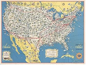
American Airlines System Map Route of the Flagships - Vibrant map of the United States highlighting the domestic airlines in operation during the early 1950's.
Published by c. 1950, 1950
Seller: Curtis Wright Maps, Berwyn, IL, U.S.A.
Seller rating 4 out of 5 stars
Condition: Fine. Published near the beginning of air travel's ascendancy (overtaking rail), this pictorial map outlines the flight routes available to travelers in the United States, Canada, and Mexico shortly after the end of WWII. Routes operated by American and other companies are shown, as this was a time when regional airlines still dominated a large section of the market. The workhorse of the fleet, the DC-3, is shown on the cover and revolutionized consumer air travel in the United States. However, a coast-to-coast flight would still require several refueling stops and take as long as 20 hours! Small illustrations highlight many of the natural attractions, historic sites, and important landmarks accessible by air across the country, and strip maps on the verso provide further information on twelve of the most popular routes across the country. Sheet Width (in) 31.75 Sheet Height (in) 23.75 Condition Description Very light wear and creasing along originally issued fold lines. Near fine condition overall.
-
???????.?????????????????. [Amerika Gassh?koku. Shuy? chih? shigen sanbutsu oyobi f?kei eiri chizu]. [Pictorial Map of the United States of America Showing Principal Regional Resources, Products and Natural Features].
Published by ???. [Kokumish?]. No date. (circa1955)., Washington D.C., 1955
Seller: Asia Bookroom ANZAAB/ILAB, Canberra, ACT, Australia
Association Member: ANZAAB ILAB
Seller rating 5 out of 5 stars
Large folding Japanese coloured map of the United States, with 3 inset maps at foot of map showing main railways, air and highway routes and hemispheres at the top right. Some browning mainly visible on reverse, still a good copy. 66 x 81cm. An intricate and detailed pictorial map of the United States, published in Japanese by the US State Department. The same type of map had been published since 1945 in English and subsequently in other languages. The Japanese language map is hard to find. The map is undated, but was probably produced in the 1950's. The images include depictions of women board riders in two piece swimsuits of the sort popular in the 1950s, but the inset text lists Alaska and Hawaii as external territories of the US, indicating that the map was produced before they attained statehood in 1959. An inset panel provides information on the area and population of the US, the population of major American cities, mineral and other resources, climate and topography. A note at the bottom right hand corner of the map states that copies of the map can be obtained free of charge from your nearest US Information Office. Every region of the country is decorated with an illustration of the natural resources, industries or cultural or historical resources associated with that particular place. These include images of early colonial settlers, the birthplaces of Mark Twain and Woodrow Wilson, Booker T. Washington's house and Abraham Lincoln's grave; images of major dams, oil fields, coal mines, cotton plantations etc., various animals and crops and images of ships, cars and public buildings (including the Statue of Liberty, located rather oddly far out at sea).
-
Map of the easterly half of Cuba showing the mills of Compania Azucarera Vertientes - Scarce prospectus for growing sugar in Cuba during the Roaring '20s.
Publication Date: 1922
Seller: Curtis Wright Maps, Berwyn, IL, U.S.A.
Seller rating 4 out of 5 stars
Condition: Fine. "The Vertientes Sugar Company was established in Cuba in 1914 and opened its first mill, Agramonte, the following year. Production gradually increased after World War I, culminating in over 270,000 bags in 1922. However, additional capital was needed to expand production capacity, and this circular was distributed in late 1922 or early 1923 to solicit funding through the National City Company of New York. Ten million dollars were to be raised through the sale of bonds offering a 7% yield in the hopes of increasing production to 750,000 bags annually. The two-page pamphlet provides cherry-picked financial statements and statistics, letters of support, and a perfectly squared company balance sheet. A small map designed by the General Drafting Company shows the location of the two mills in operation by the Compania Azucarera Vertientes, as well as the local branches of the National City Bank of New York. Source: The Morgan Library" Sheet Width (in) 8.5 Sheet Height (in) 14 Condition Description "Double-sided two page proof prospectus, folded into a tri-panel brochure. Moderate toning along the uppermost fold line on the front page, but otherwise in very good condition. Includes a small map that measure about 6.5" x 3.5" .".
-
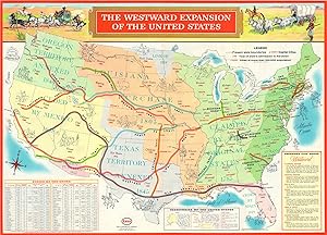
The Westward Expansion of the United States - Rosy overview of the American conquest of much of North America.
Publication Date: 1958
Seller: Curtis Wright Maps, Berwyn, IL, U.S.A.
Seller rating 4 out of 5 stars
Condition: Fine. This colorful overview of the United States highlights the gradual development of the modern day conception of America and its overseas possessions. Various stages of the country's development are shown in different shades, with little mention of the inevitable conflict resulting from the growth. Major early trails and roads are also colored and labeled, linking America's expansion and apparently inevitable success with its system of transportation. The attempted association is unsurprising, given the image was produced and distributed by General Drafting Company, a division of the Esso Oil Company and strong proponent of the growing Interstate Highway System. The verso of the image features an attractive pictorial map of early colonial America, with numerous illustrated vignettes showing important historical events east of the Mississippi River. Accompanying the map is a list of Famous Flags of Colonial America and a brief Euro-centric history of the early colonization of the continent. Sheet Width (in) 33.5 Sheet Height (in) 23.9 Condition Description Originally folded into 20 panels, with faint creasing along fold lines. Otherwise in fine condition.


![Seller image for Southern Cruising Guide - Savannah, Jacksonville, Miami, Key West, Tampa, and Gulf Coast to New Orleans. [Gulf Coast Navigation, Florida Waterways, Illustrated Nautical Chart, Corporate Travel Ephemera] for sale by Blind-Horse-Books (ABAA)](https://pictures.abebooks.com/inventory/md/md32381554843.jpg)
![Seller image for Atlantic Road Map Pennsylvania - Delaware [Title on Verso] - " "THERE IS AN ATLANTIC PUMP ON THE ROAD YOU ARE TRAVELING" " for sale by Curtis Wright Maps](https://pictures.abebooks.com/inventory/md/md31695373546.jpg)

![Seller image for ???????.?????????????????. [Amerika Gassh?koku. Shuy? chih? shigen sanbutsu oyobi f?kei eiri chizu]. [Pictorial Map of the United States of America Showing Principal Regional Resources, Products and Natural Features]. for sale by Asia Bookroom ANZAAB/ILAB](https://pictures.abebooks.com/inventory/md/md31966588282.jpg)