
Order Total (1 Item Items):
Shipping Destination:

H F Walling C E (23 results)
Feedback
Skip to main search results
Search filters
Product Type
- All Product Types
- Books (23)
- Magazines & Periodicals (No further results match this refinement)
- Comics (No further results match this refinement)
- Sheet Music (No further results match this refinement)
- Art, Prints & Posters (No further results match this refinement)
- Photographs (No further results match this refinement)
- Maps (No further results match this refinement)
- Manuscripts & Paper Collectibles (No further results match this refinement)
Condition Learn more
- New (No further results match this refinement)
- As New, Fine or Near Fine (No further results match this refinement)
- Very Good or Good (No further results match this refinement)
- Fair or Poor (No further results match this refinement)
- As Described (23)
Binding
- All Bindings
- Hardcover (2)
- Softcover (No further results match this refinement)
Collectible Attributes
- First Edition (1)
- Signed (No further results match this refinement)
- Dust Jacket (No further results match this refinement)
- Seller-Supplied Images (21)
- Not Print on Demand (23)
Language (1)
Price
- Any Price
- Under US$ 25 (No further results match this refinement)
- US$ 25 to US$ 50
- Over US$ 50
Free Shipping
- Free Shipping to U.S.A. (No further results match this refinement)
Seller Location
Seller Rating
-
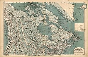
Map to Illustrate the Climatology of the Dominion of Canada
Publication Date: 1875
Seller: Art Source International Inc., Boulder, CO, U.S.A.
Seller rating 2 out of 5 stars

H. F. Walling made the maps in "Tackaburys Atlas of the Dominion of Canada" in 1875. This map shows the climatological features of the Dominion of Canada. A key describes the features used to identify seasonal temperatures and rainfall (partially obscured by the remains of a label that was placed on top of the key). This map measures 50 inches by 26 inches.
-
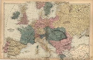
Map of Europe
Publication Date: 1875
Seller: Art Source International Inc., Boulder, CO, U.S.A.
Seller rating 2 out of 5 stars
H. F. Walling made the maps in "Tackaburys Atlas of the Dominion of Canada" in 1875. These detailed county maps show the names of counties and cities, rivers and lakes. Europe is illustrated on this beautiful, hand colored double page map. The bottom of the map continues through the margins to the edge of the page. This map measures 50 inches by 25.25 inches.
-

Atlas of the Dominion of Canada with General Descriptions by T.Sterry Hunt LL.D., F.R.S., Etc, ; Robert Bell, C.E., F.G.S., Etc; A.R.C. Selwyn, F.G.S.,Etc: H. Alleyne Nicholson, M.D., D.Sc., F.R.S.E., Etc.; W.H. Ellis, M.A.; H.H. Miles, Ll.D., D.C.L.,J.George Hodgins, L.L.D., Etc; WM. Canniff, M.D., M.R.C.S., (Eng.), Lorin Blodget, Esq; Hugh Fletcher, and Charles Robb, C.E.
Published by George N. Tackabury, Montreal,Toronto, London, 1876
Seller: Alexandre Antique Prints, Maps & Books, Toronto, ON, Canada
Seller rating 5 out of 5 stars

US$ 1,250.00
Convert currencyUS$ 6.00 shipping from Canada to U.S.A.Quantity: 1 available
Add to basketOriginal full calf boards with matching tooled gilt morocco boards., Size : Folio: 445mm x 355mm, Illustrated with maps of which include the following:Map of the Dominion of Canada Colored to show the principal geological formations, Map of the Canadian Pacific Railway Between Manitoba and Lake Nipissing, Map to Illustrate the climatology of the Dominion of Canada, Map of the Dominion of Canada and the British Possessions in North America with a portion of the United States, Atlas of the Dominion Map of British Columbia, Map of the Province of New Brunswick, Map of the Province of Manitoba, Map of the Province of Nova Scotia, Map of Newfoundland, Map of the Western Part of the Province of Quebec Canada, Map of the Central Part of the Province of Quebec Canada, Map of the Eastern Part of the Province of Quebec Canada, Map of the Western Part of the Algoma District of the North Shore of Lake Superior, Map of the Eastern Part of Algoma District of the North Shore of Lake Huron, Map of the Province of Ontario Shewing Counties, Electoral Districts, Township, Railways Et., Discrtict of Nipissing Province of Ontario, Counties of Kent and Essex Provice of Ontario, City of Toronto, Counties of Middlesex, Elgin, Lambton, Counties fof Huron, Wellington, Perth, and Waterloo, City of Montreal, Counties of Oxford, Brant Wentworth, Norfolk and Haldmand Province of Ontario, Counties of Lincoln and Welland Province of Ontario, Counties of Peterboro, Victoria, Northumberland and Durham. Province of Ontario, County of Bruce. Province of Ontario, County of Grey. Province of Ontario, Counties of Hastings, Frontenac, Addington, Prince Edward and Lenox. Province of Ontario, District of Moskoka Province of Ontario, Counties of Joliette, Berthier, Maskinonge, Laval, Montcalm, L?Assomtion, Two Mountains, Terrebonne, Argenteuil, Vaudreuil, Soulanges, Jacque Cartier, Hochelaga, Huntingdon, Beauharnois, Chateauguay, St. John?s, Napierville, Laprairie, Vercheres and Chambly. Province of Quebec, Counties of Halton, Peel, York and Ontario. Province of Ontario, County of Simcoe. Province of Ontario, Counties of St. Maurice, Champlain, Maskinonge, St. Hyacinthe, Richeliu, Iberville, Rouville, Missiquoi, Nicolet, Arthabaska, Yamaska, Drummond, Richmond, Shefford, Bagot, Brome, Stanstead, and Sherbrooke Town. Province of Quebec., County of Refrew. Province of Ontario, Plan of Ottawa. Carlton County Ontario, Counties of Lanark, Leeds, Grenville, and Carelton, Counties of Dundas, Russell, Prescott, Stormont, and Glengary. Province of Ontario, Plan of Hamilton Wehntworth County Ontario, Plan of London Middlesex County Ontario, Counties of Quebecm Monmorency, Portneuf, Lislet, Montmagny, Bellechasse, Dorchester, Levis and Lotvinere. Province of Quebec, County of Pontiac Province of Quebec, County of Ottawa Province of Quebec , County of Chicoutimi and part of Saguenay Province of Quebec, Counties of Wolfe and Compton Province of Quebec, Counties of Beauce and Megantic Province of Quebec, Counties of Temiscouata with parts of Saguenay, Bonaventure and Rimouski. Province of Quebec, Plan of Kingston Frontenac County Ontario; Plan of the City of Quebec; County of Gaspe and parts of Bonaventure and Rimouski, Province of Quebc; Counties of Charlivoix and Kamouaska, Province of Quebec, Map of the United States of America, Map of Europe. Boards and spine are worn but otherwise in good condtion. Maps are clean.
-
Tackabury`s Atlas of the Dominion of Canada with General Descriptions by T.Sterry Hunt LL.D., F.R.S., Etc, ; Robert Bell, C.E., F.G.S., Etc; A.R.C. Selwyn, F.G.S.,Etc: H. Alleyne Nicholson, M.D., D.Sc., F.R.S.E., Etc.; W.H. Ellis, M.A.; H.H. Miles, Ll.D., D.C.L.,J.George Hodgins, L.L.D., Etc; WM. Canniff, M.D., M.R.C.S., (Eng.), Lorin Blodget, Esq; Hugh Fletcher, and Charles Robb, C.E.
Published by George N. Tackabury, Montreal,Toronto, London, 1875
Seller: Alexandre Antique Prints, Maps & Books, Toronto, ON, Canada
Seller rating 5 out of 5 stars
First Edition
US$ 1,375.00
Convert currencyUS$ 6.00 shipping from Canada to U.S.A.Quantity: 1 available
Add to basketEdition : 1st Edition , Original full calf boards with matching tooled gilt morocco boards., Size : Folio: 445mm x 355mm, Illustrated with maps of which include the following:Map of the Dominion of Canada Colored to show the principal geological formations, Map of the Canadian Pacific Railway Between Manitoba and Lake Nipissing, Map to Illustrate the climatology of the Dominion of Canada, Map of the Dominion of Canada and the British Possessions in North America with a portion of the United States, Atlas of the Dominion Map of British Columbia, Map of the Province of New Brunswick, Map of the Province of Manitoba, Map of the Province of Nova Scotia, Map of Newfoundland, Map of the Western Part of the Province of Quebec Canada, Map of the Central Part of the Province of Quebec Canada, Map of the Eastern Part of the Province of Quebec Canada, Map of the Western Part of the Algoma District of the North Shore of Lake Superior, Map of the Eastern Part of Algoma District of the North Shore of Lake Huron, Map of the Province of Ontario Shewing Counties, Electoral Districts, Township, Railways Et., Discrtict of Nipissing Province of Ontario, Counties of Kent and Essex Provice of Ontario, City of Toronto, Counties of Middlesex, Elgin, Lambton, Counties of Huron, Wellington, Perth, and Waterloo, City of Montreal, Counties of Oxford, Brant Wentworth, Norfolk and Haldmand Province of Ontario, Counties of Lincoln and Welland Province of Ontario, Counties of Peterboro, Victoria, Northumberland and Durham. Province of Ontario, County of Bruce. Province of Ontario, County of Grey. Province of Ontario, Counties of Hastings, Frontenac, Addington, Prince Edward and Lenox. Province of Ontario, District of Moskoka Province of Ontario, Counties of Joliette, Berthier, Maskinonge, Laval, Montcalm, L?Assomtion, Two Mountains, Terrebonne, Argenteuil, Vaudreuil, Soulanges, Jacque Cartier, Hochelaga, Huntingdon, Beauharnois, Chateauguay, St. John?s, Napierville, Laprairie, Vercheres and Chambly. Province of Quebec, Counties of Halton, Peel, York and Ontario. Province of Ontario, County of Simcoe. Province of Ontario, Counties of St. Maurice, Champlain, Maskinonge, St. Hyacinthe, Richeliu, Iberville, Rouville, Missiquoi, Nicolet, Arthabaska, Yamaska, Drummond, Richmond, Shefford, Bagot, Brome, Stanstead, and Sherbrooke Town. Province of Quebec., County of Refrew. Province of Ontario, Plan of Ottawa. Carlton County Ontario, Counties of Lanark, Leeds, Grenville, and Carelton, Counties of Dundas, Russell, Prescott, Stormont, and Glengary. Province of Ontario, Plan of Hamilton Wehntworth County Ontario, Plan of London Middlesex County Ontario, Counties of Quebecm Monmorency, Portneuf, Lislet, Montmagny, Bellechasse, Dorchester, Levis and Lotvinere. Province of Quebec, County of Pontiac Province of Quebec, County of Ottawa Province of Quebec , County of Chicoutimi and part of Saguenay Province of Quebec, Counties of Wolfe and Compton Province of Quebec, Counties of Beauce and Megantic Province of Quebec, Counties of Temiscouata with parts of Saguenay, Bonaventure and Rimouski. Province of Quebec, Plan of Kingston Frontenac County Ontario; Plan of the City of Quebec; County of Gaspe and parts of Bonaventure and Rimouski, Province of Quebc; Counties of Charlivoix and Kamouaska, Province of Quebec, Map of the United States of America, Map of Europe. Boards and spine are slightly worn but otherwise a very good copy. Maps are clean and crisp.
-

Map of the Western Part of Algoma District on the North Shore of Lake Superior
Publication Date: 1875
Seller: Art Source International Inc., Boulder, CO, U.S.A.
Seller rating 2 out of 5 stars
H. F. Walling made the maps in "Tackaburys Atlas of the Dominion of Canada" in 1875. These detailed, hand colored county maps show the names of counties and cities, rivers, lakes, important landmarks and the names of major land owners. Western Algoma on the north shore of Lake Superior is illustrated on this beautiful pastel colored map. This map measures 13.25 inches by 11 inches.
-

Map of the Western Part of the Province of Quebec, Canada
Publication Date: 1875
Seller: Art Source International Inc., Boulder, CO, U.S.A.
Seller rating 2 out of 5 stars
H. F. Walling made the maps in "Tackaburys Atlas of the Dominion of Canada" in 1875. These detailed, hand colored county maps show the names of counties and cities, rivers, lakes, important landmarks and the names of major land owners. The western portion of Quebec is illustrated on this beautiful pastel colored map. This map measures 60 inches by 24 inches.
-

Counties of Charlevoix and Kamouraski- Province of Quebec
Publication Date: 1875
Seller: Art Source International Inc., Boulder, CO, U.S.A.
Seller rating 2 out of 5 stars
H. F. Walling made the maps in "Tackaburys Atlas of the Dominion of Canada" in 1875. These detailed, hand colored county maps show the names of counties and cities, rivers, lakes, important landmarks and the names of major land owners. The counties of Charlevoix and Kamouraska in Quebec are illustrated on this beautiful pastel map. This map measures 65 inches by 16.75 inches.
-

Map of the Dominion of Canada and the British Possessions in North America with a portion of the United States
Publication Date: 1875
Seller: Art Source International Inc., Boulder, CO, U.S.A.
Seller rating 2 out of 5 stars
H. F. Walling made the maps in "Tackaburys Atlas of the Dominion of Canada" in 1875. These detailed county maps show the names of counties and cities, rivers, lakes, important landmarks and the names of major land owners. The Dominion of Canada and North American British Possessions are illustrated on this beautiful double page, hand colored map. An inset shows the environs of Kennedy Channel and Smith Strait. This map measures 25.5 inches by 16.5 inches.
-

County of Gaspe and parts of Bonaventure and Rimouski- Province of Quebec
Publication Date: 1875
Seller: Art Source International Inc., Boulder, CO, U.S.A.
Seller rating 2 out of 5 stars
H. F. Walling made the maps in "Tackaburys Atlas of the Dominion of Canada" in 1875. These detailed, hand colored county maps show the names of counties and cities, rivers, lakes, important landmarks and the names of major land owners. The county of Gaspe, and parts of Bonaventure and Rimouski in Quebec are illustrated on this beautiful double page map. This map measures 75 inches by 26 inches.
-

Map of the Central Part of the Province of Quebec, Canada
Publication Date: 1875
Seller: Art Source International Inc., Boulder, CO, U.S.A.
Seller rating 2 out of 5 stars
H. F. Walling made the maps in "Tackaburys Atlas of the Dominion of Canada" in 1875. These detailed, hand colored county maps show the names of counties and cities, rivers, lakes, important landmarks and the names of major land owners. The central portion of Quebec is illustrated on this beautiful pastel colored map. This map measures 85 inches by 15 inches.
-

Map of the Eastern Part of the Province of Quebec, Canada
Publication Date: 1875
Seller: Art Source International Inc., Boulder, CO, U.S.A.
Seller rating 2 out of 5 stars
H. F. Walling made the maps in "Tackaburys Atlas of the Dominion of Canada" in 1875. These detailed, hand colored county maps show the names of counties and cities, rivers, lakes, important landmarks and the names of major land owners. The eastern portion of Quebec is illustrated on this beautiful pastel colored map. This map measures 85 inches by 23.25 inches.
-

Plan of the City of Quebec
Publication Date: 1875
Seller: Art Source International Inc., Boulder, CO, U.S.A.
Seller rating 2 out of 5 stars
H. F. Walling made the maps in "Tackaburys Atlas of the Dominion of Canada" in 1875. These detailed, hand colored county maps show the names of counties and cities, rivers, lakes, important landmarks and the names of major land owners. The plan of the city of Quebec is illustrated on this beautiful pastel map. An inset has a key listing many important buildings and landmarks. This map measures 85 inches by 15.5 inches.
-

County of Simcoe- Province of Ontario
Publication Date: 1875
Seller: Art Source International Inc., Boulder, CO, U.S.A.
Seller rating 2 out of 5 stars
H. F. Walling made the maps in "Tackaburys Atlas of the Dominion of Canada" in 1875. These detailed, hand colored county maps show the names of counties and cities, rivers, lakes, important landmarks and the names of major land owners. The county of Simcoe in Ontario is illustrated on this beautiful pastel map. This map measures 85 inches by 11 inches.
-

Map of the Province of New Brunswick
Publication Date: 1875
Seller: Art Source International Inc., Boulder, CO, U.S.A.
Seller rating 2 out of 5 stars
H. F. Walling made the maps in "Tackaburys Atlas of the Dominion of Canada" in 1875. These detailed, hand colored county maps show the names of counties and cities, rivers, lakes, important landmarks and the names of major land owners. New Brunswick is illustrated on this beautiful pastel colored map. The bottom of the map runs off the page at the Bay of Fundy. This map measures 85 inches by 15 inches.
-

Map of the Province of Nova Scotia
Publication Date: 1875
Seller: Art Source International Inc., Boulder, CO, U.S.A.
Seller rating 2 out of 5 stars
H. F. Walling made the maps in "Tackaburys Atlas of the Dominion of Canada" in 1875. These detailed, hand colored county maps show the names of counties and cities, rivers, lakes, important landmarks and the names of major land owners. Nova Scotia is illustrated on this beautiful pastel colored map. The bottom of the map continues through the margins, into the fold. This map measures 85 inches by 17.5 inches.
-

Counties of Wolfe and Compton- Province of Quebec
Publication Date: 1875
Seller: Art Source International Inc., Boulder, CO, U.S.A.
Seller rating 2 out of 5 stars
H. F. Walling made the maps in "Tackaburys Atlas of the Dominion of Canada" in 1875. These detailed, hand colored county maps show the names of counties and cities, rivers, lakes, important landmarks and the names of major land owners. The Counties of Wolfe and Compton in Quebec are illustrated on this beautiful pastel map. This map measures 85 inches by 10.75 inches.
-

Map of Newfoundland
Publication Date: 1875
Seller: Art Source International Inc., Boulder, CO, U.S.A.
Seller rating 2 out of 5 stars
H. F. Walling made the maps in "Tackaburys Atlas of the Dominion of Canada" in 1875. These detailed county maps show the names of counties and cities, rivers, lakes, important landmarks and the names of major land owners. Newfouldland is illustrated on this beautiful pink and blue colored map. This map measures 85 inches by 11.75 inches.
-

County of Renfrew- Province of Ontario
Publication Date: 1875
Seller: Art Source International Inc., Boulder, CO, U.S.A.
Seller rating 2 out of 5 stars
H. F. Walling made the maps in "Tackaburys Atlas of the Dominion of Canada" in 1875. These detailed, hand colored county maps show the names of counties and cities, rivers, lakes, important landmarks and the names of major land owners. The county of Renfrew in Ontario is illustrated on this beautiful pastel map. This map measures 85 inches by 11.75 inches.
-

Map of the Canadian Pacific Railway Between Manitoba and Lake Nipissing
Publication Date: 1875
Seller: Art Source International Inc., Boulder, CO, U.S.A.
Seller rating 2 out of 5 stars
H. F. Walling made the maps in "Tackaburys Atlas of the Dominion of Canada" in 1875. This map shows the Canadian Pacific Railway from Manitoba to Lake Nipissing as mapped in 1874. This map measures 85 inches by 11 inches.
-

County of Temiscouata with parts of Saguenay, Bonaventure and Rimouski. Province of Quebec
Publication Date: 1875
Seller: Art Source International Inc., Boulder, CO, U.S.A.
Seller rating 2 out of 5 stars
H. F. Walling made the maps in "Tackaburys Atlas of the Dominion of Canada" in 1875. These detailed, hand colored county maps show the names of counties and cities, rivers, lakes, important landmarks and the names of major land owners. The counties of Temiscouata with parts of Saguenay, Bonaventure and Rimouski, in Quebec are illustrated on this beautiful double page map. This map measures 85 inches by 16.25 inches.
-

Plan of Ottawa, Carleton County, Ontario, Canada
Publication Date: 1875
Seller: Art Source International Inc., Boulder, CO, U.S.A.
Seller rating 2 out of 5 stars
H. F. Walling made the maps in "Tackaburys Atlas of the Dominion of Canada" in 1875. These detailed, hand colored county maps show the names of counties and cities, rivers, lakes, important landmarks and the names of major land owners. A plan of Ottawa, Ontario is illustrated on this beautiful pastel map. This map measures 14.25 inches by 13.25 inches.
-

Map of the Province of Manitoba
Publication Date: 1875
Seller: Art Source International Inc., Boulder, CO, U.S.A.
Seller rating 2 out of 5 stars
H. F. Walling made the maps in "Tackaburys Atlas of the Dominion of Canada" in 1875. These detailed, hand colored county maps show the names of counties and cities, rivers, lakes, important landmarks and the names of major land owners. Manitoba is illustrated on this beautiful pastel colored map. This map measures 100 inches by 19 inches.
-

Counties of St. Maurice, Champlain, Maskinonge, St. Hyacinthe, Richelieu, Iberville, Rouville, Missisquoi, Nicolet, Arthabaska, Yamaska, Drummond, Richmond, Shefford, Bagot, Brome, Stanstead and Sherbrooke Town- Province of Quebec
Publication Date: 1875
Seller: Art Source International Inc., Boulder, CO, U.S.A.
Seller rating 2 out of 5 stars
H. F. Walling made the maps in "Tackaburys Atlas of the Dominion of Canada" in 1875. These detailed, hand colored county maps show the names of counties and cities, rivers, lakes, important landmarks and the names of major land owners. The counties of St. Maurice, Champlain, Maskinonge, St. Hyacinthe, Richelieu, Iberville, Rouville, Missisquoi, Nicolet, Arthabaska, Yamaska, Drummond, Richmond, Shefford, Bagot, Brome, Stanstead and Sherbrooke Town in Quebec are illustrated on this beautiful pastel map. This map measures 16.5 inches by 24.5 inches.
