Heydrick Mapping (9 results)

Heydrick's Ownership Map of Collingsworth County, Texas. Scale 1 Inch = 4000 Feet.
Wells and Wells / Heydrick Mapping Company (Lawrence C. Heydrick and Waldo H. Haven).
Published by Heydrick Mapping Company., Corpus Christi, Texas, U.S.A., 1954
- Map
Seller: Eryops Books, Stephenville, TX, U.S.A.Eryops Books
Contact seller5-star sellerCondition: Used - Very good
US$ 19.95
US$ 6.00 shippingShips within U.S.A.Quantity: 1 available
No Binding. Condition: Very Good. Large Folded Ownership Map (45 X 43 inches!); in very good condition. Map.

Published by Wichita Falls, Texas, Wichita Falls, Texas, 1950
Seller: High Ridge Books, Inc. - ABAA, South Deerfield, MA, U.S.A.High Ridge Books, Inc. - ABAA
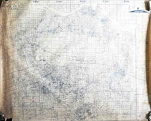
Contact seller5-star sellerUncolored unbacked map of this county in the north central Texas panhandle, printed in blue. fine condition with minor staining near the top and a few manuscript notations. Land owners identified throughout. Also identifies oil exploration results, with drilling, producing, gas and abandoned wells shown, along with dry holes. Mo…st striking are the depictions of three oil derricks, one of which is gushing oil, in the cartouche at the top right. The map was copyrighted in 1950 and bears a rubber stamp with a date in 1952.

Published by Wichita Falls, TX, Wichita Falls, TX, 1952
Seller: High Ridge Books, Inc. - ABAA, South Deerfield, MA, U.S.A.High Ridge Books, Inc. - ABAA
Contact seller5-star sellerSurvey map of Gray County, Texas, showing property lines, ownership, and plat numbers. Discoloration across the bottom from outer roll being exposed. The map also includes towns, bodies of water, roads, railroads, and oil fields. A legend indicating drilling wells, gas wells, abandoned wells, and dry holes is included in the upp…er-right corner. Copyrighted in 1947, this map has a rubber stamp indicating that it was dated August 14, 1952. Gray County is in the northern Texas panhandle, east of Amarillo. Heydrick Mapping Co. produced maps of the areas in Texas which had active oil drilling. Their logo at the top right supports this niche. Some counties were mapped by Heydrick as early as the 1870's, while others, like Gray County, were not mapped until oil was discovered. Heydrick's maps were produced in relatively small numbers and are quite scarce.
Published by Wichita Falls, TX, Wichita Falls, TX, 1950
Seller: High Ridge Books, Inc. - ABAA, South Deerfield, MA, U.S.A.High Ridge Books, Inc. - ABAA
Contact seller5-star sellerUncolored survey map of Wichita County, Texas, containing the city of Wichita Falls, showing property lines, ownership, owners of drilling rights, and plat numbers. Very good condition, with small loss at bottom left corner and discoloration at sides. Also includes towns, bodies of water, roads, railroads, and oil fields. A lege…nd indicating drilling wells, gas wells, abandoned wells, and dry holes is included in the upper-right corner. Copyrighted in 1947, this map has a rubber stamp indicating that it was updated to April 12, 1950. Heydrick Mapping Co. produced maps of the areas in Texas which had active oil drilling. Their logo at the top right supports this niche. Some counties were mapped by Heydrick as early as the 1870's, while others were not mapped until oil was discovered. Heydrick's maps were produced in relatively small numbers and are quite scarce.

Published by Wichita Falls, TX, Wichita Falls, TX, 1952
Seller: High Ridge Books, Inc. - ABAA, South Deerfield, MA, U.S.A.High Ridge Books, Inc. - ABAA
Contact seller5-star sellerUncolored survey map of Carson County, Texas, just east of Amarillo, showing property lines, ownership, owners of drilling rights, and plat numbers. fine condition. Also includes towns, bodies of water, roads, railroads, and oil fields. A legend indicating drilling wells, gas wells, abandoned wells, and dry holes is included in…the upper-right corner. Copyrighted in 1947, this map has a rubber stamp indicating that it was updated to August 14, 1952. Heydrick Mapping Co. produced maps of the areas in Texas which had active oil drilling. Their logo at the top right supports this niche. Some counties were mapped by Heydrick as early as the 1870's, while others were not mapped until oil was discovered. Heydrick's maps were produced in relatively small numbers and are quite scarce.

Published by Wichita Falls, TX, Wichita Falls, TX, 1950
Seller: High Ridge Books, Inc. - ABAA, South Deerfield, MA, U.S.A.High Ridge Books, Inc. - ABAA
Contact seller5-star sellerUncolored survey map of Clay County, Texas, east of Wichita Falls and north of Fort Worth, showing property lines, ownership, and plat numbers. fine condition, with two small areas of discoloration at the bottom. Also includes towns, bodies of water, roads, railroads, and oil fields. A legend indicating drilling wells, gas wells…, abandoned wells, and dry holes is included in the upper-right corner. Copyrighted in 1947, this map has a rubber stamp indicating that it was updated to April 12, 1950. Heydrick Mapping Co. produced maps of the areas in Texas which had active oil drilling. Their logo at the top right supports this niche. Some counties were mapped by Heydrick as early as the 1870's, while others were not mapped until oil was discovered. Heydrick's maps were produced in relatively small numbers and are quite scarce.

Published by Wichita Falls, TX, Wichita Falls, TX, 1952
Seller: High Ridge Books, Inc. - ABAA, South Deerfield, MA, U.S.A.High Ridge Books, Inc. - ABAA
Contact seller5-star sellerSurvey map of Baylor County, Texas, showing property lines, ownership, and plat numbers. Some creasing at the top edge. The map also includes towns, bodies of water, roads, railroads, and oil fields. A legend indicating drilling wells, gas wells, abandoned wells, and dry holes is included in the upper-right corner. Copyrighted i…n 1948, this map has a rubber stamp indicating that it was updated to August 11, 1952. Donley County is in North Texas, southwest of Wichita Falls. Heydrick Mapping Co. produced maps of the areas in Texas which had active oil drilling. Their logo at the top right supports this niche. Some counties were mapped by Heydrick as early as the 1870's, while others, like Donley County, were not mapped until oil was discovered. Heydrick's maps were produced in relatively small numbers and are quite scarce.

Published by Wichita Falls, TX, Wichita Falls, TX, 1952
Seller: High Ridge Books, Inc. - ABAA, South Deerfield, MA, U.S.A.High Ridge Books, Inc. - ABAA
Contact seller5-star sellerSurvey map of Donley County, Texas, showing property lines, ownership, and plat numbers. The map also includes towns, bodies of water, roads, railroads, and oil fields. A legend indicating drilling wells, gas wells, abandoned wells, and dry holes is included in the upper-right corner. Copyrighted in 1950, this map has a rubber s…tamp indicating that it was dated August 14, 1952. Donley County is in the northern Texas panhandle, east of Amarillo. Heydrick Mapping Co. produced maps of the areas in Texas which had active oil drilling. Their logo at the top right supports this niche. Some counties were mapped by Heydrick as early as the 1870's, while others, like Donley County, were not mapped until oil was discovered. Heydrick's maps were produced in relatively small numbers and are quite scarce.


