Order Total (1 Item Items):
Shipping Destination:

Hondius Jodocus (923 results)
Skip to main search results
Search filters
Product Type
- All Product Types
- Books (248)
- Magazines & Periodicals (No further results match this refinement)
- Comics (No further results match this refinement)
- Sheet Music (No further results match this refinement)
- Art, Prints & Posters (158)
- Photographs (No further results match this refinement)
- Maps (516)
- Manuscripts & Paper Collectibles (1)
Condition Learn more
Binding
Collectible Attributes
- First Edition (169)
- Signed (No further results match this refinement)
- Dust Jacket (2)
- Seller-Supplied Images (690)
- Not Print on Demand (858)
Language (6)
Free Shipping
Seller Location
Seller Rating
-

Map Of The World
Seller: Rarewaves.com USA, London, LONDO, United Kingdom
Seller rating 5 out of 5 stars

US$ 19.38
Free Shipping
Ships from United Kingdom to U.S.A.Quantity: Over 20 available
Add to basketPaperback. Condition: New.
-

PAP. Condition: New. New Book. Shipped from UK. Established seller since 2000.
-

The World Map of 1669 / by Jodocus Hondius the Elder and Nicolaes Visscher ; Gunter Schilder
Language: English
Published by Amsterdam : N. Israel, 1669
ISBN 10: 9060721195 ISBN 13: 9789060721193
US$ 13.13
US$ 13.55 shipping
Ships from United Kingdom to U.S.A.Quantity: 1 available
Add to basketPaperback. Condition: New.
-
Map of the World Classic Reprint
Seller: PBShop.store UK, Fairford, GLOS, United Kingdom
Seller rating 4 out of 5 stars

US$ 23.61
US$ 4.41 shipping
Ships from United Kingdom to U.S.A.Quantity: 15 available
Add to basketPAP. Condition: New. New Book. Shipped from UK. Established seller since 2000.
-

Condition: New.
-
Map of the World by Jodocus Hondius, 1611
Seller: Ria Christie Collections, Uxbridge, United Kingdom
Seller rating 5 out of 5 stars
US$ 17.66
US$ 16.07 shipping
Ships from United Kingdom to U.S.A.Quantity: Over 20 available
Add to basketCondition: New. In.
-

Map Of The World
Seller: Ria Christie Collections, Uxbridge, United Kingdom
Seller rating 5 out of 5 stars
US$ 17.67
US$ 16.07 shipping
Ships from United Kingdom to U.S.A.Quantity: Over 20 available
Add to basketCondition: New. In.
-

Map of the World by Jodocus Hondius, 1611;; text
Seller: Ria Christie Collections, Uxbridge, United Kingdom
Seller rating 5 out of 5 stars
US$ 18.59
US$ 16.07 shipping
Ships from United Kingdom to U.S.A.Quantity: Over 20 available
Add to basketCondition: New. In.
-
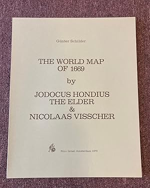
The World Map of 1669
Language: English
Published by Nico Israel Da Capo Press, Amsterdam, 1978
ISBN 10: 9060721195 ISBN 13: 9789060721193
Softcover. Condition: Fine. Folio. We specialize in fine books in collectible condition. Orders are professionally packaged and shipped promptly. P40.
-

Map Of The World
Seller: Ria Christie Collections, Uxbridge, United Kingdom
Seller rating 5 out of 5 stars
US$ 31.90
US$ 16.07 shipping
Ships from United Kingdom to U.S.A.Quantity: Over 20 available
Add to basketCondition: New. In.
-

Map of the World by Jodocus Hondius, 1611
Seller: Ria Christie Collections, Uxbridge, United Kingdom
Seller rating 5 out of 5 stars
US$ 32.17
US$ 16.07 shipping
Ships from United Kingdom to U.S.A.Quantity: Over 20 available
Add to basketCondition: New. In.
-
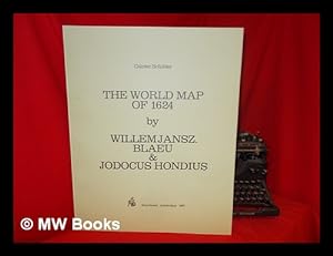
The World Map of 1624 / by Willem Jansz. Blaeu and Jodocus Hondius ; Gunter Schilder
Language: English
Published by Amsterdam : N. Israel, 1977
ISBN 10: 9060721187 ISBN 13: 9789060721186
1st Edition in this form. Fine paperback copy. Particularly and surprisingly well-preserved; tight, bright, clean and especially sharp-cornered.; 8vo 8" - 9" tall; 0 pages; Description: 17 leaves, A-V leaves of plates : ill., maps ; 56 cm. Includes bibliographical references. Reprint of the 1624 map by W. J. Blaeu, as revised and published by J. Hondius, Amsterdam. Title of original map reads: Nova universi terrarum orbis mappa. Series: Wall-maps of the 16th and 17th centuries ; 1. Subjects: World maps --Early works to 1800 --Early maps. 3 Kg.
-
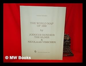
The World Map of 1669 / by Jodocus Hondius the Elder and Nicolaes Visscher ; Gunter Schilder
Language: English
Published by Amsterdam : N. Israel, 1978
ISBN 10: 9060721195 ISBN 13: 9789060721193
1st Edition in this form. Fine paperback copy. Particularly and surprisingly well-preserved; tight, bright, clean and especially sharp-cornered.; 8vo 8" - 9" tall; 0 pages; Description: 35 leaves, 20 leaves of plates : ill., maps ; 56 cm. Includes bibliographical references. Reprint of the 1669 map by J. Hondius, as updated by C. J. Visscher, published by N. Visscher, Amsterdam. Title of original map reads: Novissima ac exactissima totius orbis terrarum descriptio magna. Series: Wall-maps of the 16th and 17th centuries ; 2. Subjects: World maps --Early works to 1800. Early maps. 3 Kg.
-
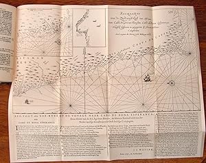
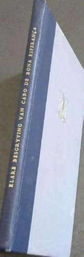
A Clear Description of the Cape of Good Hope - Klare besgryving van Cabo De Bona Esperanca
Published by Jodocus Hondius, 1952
Hardcover. Condition: Very Good. No Jacket. The boards are in a very good condition, except for some minor marks. Internally clean and tightly bound. Complete with 37 pages. English and partly Afrikaans language. [B.K.]. Our orders are shipped using tracked courier delivery services.
-

The World Map of 1624 / by Willem Jansz. Blaeu and Jodocus Hondius ; Gunter Schilder
Language: English
Published by Amsterdam : N. Israel, 1977
ISBN 10: 9060721187 ISBN 13: 9789060721186
1st Edition in this form. Fine paperback copy. Particularly and surprisingly well-preserved; tight, bright, clean and especially sharp-cornered.; 8vo 8" - 9" tall; 0 pages; Description: 17 leaves, A-V leaves of plates : ill., maps ; 56 cm. Includes bibliographical references. Reprint of the 1624 map by W. J. Blaeu, as revised and published by J. Hondius, Amsterdam. Title of original map reads: Nova universi terrarum orbis mappa. Series: Wall-maps of the 16th and 17th centuries ; 1. Subjects: World maps --Early works to 1800 --Early maps. 3 Kg. Item is Shipped from Ireland or US locations.
-

The World Map of 1669 / by Jodocus Hondius the Elder and Nicolaes Visscher ; Gunter Schilder
Language: English
Published by Amsterdam : N. Israel, 1978
ISBN 10: 9060721195 ISBN 13: 9789060721193
1st Edition in this form. Fine paperback copy. Particularly and surprisingly well-preserved; tight, bright, clean and especially sharp-cornered.; 8vo 8" - 9" tall; 0 pages; Description: 35 leaves, 20 leaves of plates : ill., maps ; 56 cm. Includes bibliographical references. Reprint of the 1669 map by J. Hondius, as updated by C. J. Visscher, published by N. Visscher, Amsterdam. Title of original map reads: Novissima ac exactissima totius orbis terrarum descriptio magna. Series: Wall-maps of the 16th and 17th centuries ; 2. Subjects: World maps --Early works to 1800. Early maps. 3 Kg. Item is Shipped from Ireland or US locations.
-

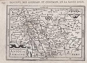
"Aniou et Lemaine" - Anjou Maine Pays de la Loire map Karte carte
Language: French
Published by Amsterdam, J. Hondius, 1618
Seller: Antiquariat Steffen V�lkel GmbH, Seubersdorf, Germany
Seller rating 5 out of 5 stars
Map First Edition
Kupferstich-Karte aus der ersten franz�sischen Ausgabe von Bertius' "Atlas Minor" gedruckt in Amsterdam bei J. Hondius im Jahre 1618. Mit franz�sischem Text auf der R�ckseite. -- Ma�e: ca. 9,5 x 13,5 cm. -- im unteren Au�enrand leicht fleckig, sonst gut erhalten. || Copper engraved map out of the first French edition of Bertius' "Atlas Minor", published by J. Hondius in Amsterdam in 1618. With French text on verso. -- slightly stained on the lower outer margin, otherwise in good condition. // Wir, das Antiquariat Steffen V�lkel, kaufen und verkaufen alte B�cher, Handschriften, Zeichnungen, Autographen, Grafiken und Fotografien. Wir sind stets am Ankauf von kompletten Bibliotheken, Sammlungen und Nachl�ssen interessiert. Sprache: Franz�sisch Gewicht in Gramm: 1550.
-

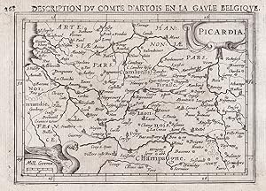
"Picardia" - Picardie Aisne Oise Somme map Karte carte
Language: French
Published by Amsterdam, J. Hondius, 1618
Seller: Antiquariat Steffen V�lkel GmbH, Seubersdorf, Germany
Seller rating 5 out of 5 stars
Map First Edition
Kupferstich-Karte aus der ersten franz�sischen Ausgabe von Bertius' "Atlas Minor" gedruckt in Amsterdam bei J. Hondius im Jahre 1618. Mit franz�sischem Text auf der R�ckseite. -- Ma�e: ca. 9,5 x 13,5 cm. -- gut erhalten. || Copper engraved map out of the first French edition of Bertius' "Atlas Minor", published by J. Hondius in Amsterdam in 1618. With French text on verso. -- in good condition. // Wir, das Antiquariat Steffen V�lkel, kaufen und verkaufen alte B�cher, Handschriften, Zeichnungen, Autographen, Grafiken und Fotografien. Wir sind stets am Ankauf von kompletten Bibliotheken, Sammlungen und Nachl�ssen interessiert. Sprache: Franz�sisch Gewicht in Gramm: 10.
-

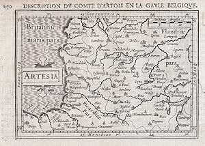
"Artesia" - Artois Pas-de-Calais Boulogne-sur-Mer map Karte carte
Language: French
Published by Amsterdam, J. Hondius, 1618
Seller: Antiquariat Steffen V�lkel GmbH, Seubersdorf, Germany
Seller rating 5 out of 5 stars
Map First Edition
Kupferstich-Karte aus der ersten franz�sischen Ausgabe von Bertius' "Atlas Minor" gedruckt in Amsterdam bei J. Hondius im Jahre 1618. Mit franz�sischem Text auf der R�ckseite. -- Ma�e: ca. 9,5 x 13,5 cm. -- rechts und unten leicht beschnitten (mit leichtem Textverlust auf der R�ckseite), sonst gut erhalten. || Copper engraved map out of the first French edition of Bertius' "Atlas Minor", published by J. Hondius in Amsterdam in 1618. With French text on verso. -- slightly cut on the lower and right margins (with some loss of text on verso), otherwise in good condition. // Wir, das Antiquariat Steffen V�lkel, kaufen und verkaufen alte B�cher, Handschriften, Zeichnungen, Autographen, Grafiken und Fotografien. Wir sind stets am Ankauf von kompletten Bibliotheken, Sammlungen und Nachl�ssen interessiert. Sprache: Franz�sisch Gewicht in Gramm: 10.
-
"Artesia" - Artois Pas-de-Calais Boulogne-sur-Mer map Karte carte
Language: French
Published by Amsterdam, J. Hondius, 1618
Seller: Antiquariat Steffen V�lkel GmbH, Seubersdorf, Germany
Seller rating 5 out of 5 stars
Map First Edition
Original Kupferstich-Karte aus der ersten franz�sischen Ausgabe von Bertius' "Atlas Minor" gedruckt in Amsterdam bei J. Hondius im Jahre 1618. Mit franz�sischem Text auf der R�ckseite. -- Blatt-Ma�e: ca. 12 x 17,5 cm. -- gut erhalten. || Original engraved map out of the first French edition of Bertius' "Atlas Minor", published by J. Hondius in Amsterdam in 1618. With French text on verso. -- in good condition. // Wir, das Antiquariat Steffen V�lkel, kaufen und verkaufen alte B�cher, Handschriften, Zeichnungen, Autographen, Grafiken und Fotografien. Wir sind stets am Ankauf von kompletten Bibliotheken, Sammlungen und Nachl�ssen interessiert. Sprache: Franz�sisch Gewicht in Gramm: 10.
-
"Aniou et Lemaine" - Anjou Maine Pays de la Loire map Karte carte
Language: French
Published by Amsterdam, J. Hondius, 1618
Seller: Antiquariat Steffen V�lkel GmbH, Seubersdorf, Germany
Seller rating 5 out of 5 stars
Map First Edition
Original Kupferstich-Karte aus der ersten franz�sischen Ausgabe von Bertius' "Atlas Minor" gedruckt in Amsterdam bei J. Hondius im Jahre 1618. Mit franz�sischem Text auf der R�ckseite. -- Blatt-Ma�e: ca. 12 x 17,5 cm. -- gut erhalten. || Original engraved map out of the first French edition of Bertius' "Atlas Minor", published by J. Hondius in Amsterdam in 1618. With French text on verso. -- in good condition. // Wir, das Antiquariat Steffen V�lkel, kaufen und verkaufen alte B�cher, Handschriften, Zeichnungen, Autographen, Grafiken und Fotografien. Wir sind stets am Ankauf von kompletten Bibliotheken, Sammlungen und Nachl�ssen interessiert. Sprache: Franz�sisch Gewicht in Gramm: 1550.
-
"Picardia" - Picardie Aisne Oise Somme map Karte carte
Language: French
Published by Amsterdam, J. Hondius, 1618
Seller: Antiquariat Steffen V�lkel GmbH, Seubersdorf, Germany
Seller rating 5 out of 5 stars
Map First Edition
Original Kupferstich-Karte aus der ersten franz�sischen Ausgabe von Bertius' "Atlas Minor" gedruckt in Amsterdam bei J. Hondius im Jahre 1618. Mit franz�sischem Text auf der R�ckseite. -- Blatt-Ma�e: ca. 12 x 17,5 cm. -- gut erhalten. || Original engraved map out of the first French edition of Bertius' "Atlas Minor", published by J. Hondius in Amsterdam in 1618. With French text on verso. -- in good condition. // Wir, das Antiquariat Steffen V�lkel, kaufen und verkaufen alte B�cher, Handschriften, Zeichnungen, Autographen, Grafiken und Fotografien. Wir sind stets am Ankauf von kompletten Bibliotheken, Sammlungen und Nachl�ssen interessiert. Sprache: Franz�sisch Gewicht in Gramm: 10.
-
A Clear Description of the Cape of Good Hope / Klare Besgryving van Cabo de Bona Esperan�a
Published by (Cape Town: Book Exhibition Committee Van Riebeeck Festival, 1952), 1952
Seller: Christison Rare Books, IOBA SABDA, Port Elizabeth, South Africa
Association Member: IOBA
Seller rating 3 out of 5 stars

Facsimile of the text compiled by Jodocus Hondius and published by him at Amsterdam in 1652, with an English translation by L. C. van Oordt and introduction and notes by Prof. P. Serton. 8vo; original blue cloth-backed grey cloth over boards, with gilt lettering to spine and gilt Van Riebeeck Festival device to upper cover; pp. xv + (i) + 33 + (i) + 37; three folding plates, and one large, folding chart. Very good condition. The introduction by P. Serton is in English with an Afrikaans translation, while the actual translation of the facsimile is in English only. Mendelssohn paraphrases the original full title and explains the work's significance as follows: "A lucid description of the Cape of Good Hope, with the adjoining coast, to Cape Negro in Angola. With information respecting the harbours, divisions, places, states, &c. As also the nature of the climate, the means of existence, crops, animals. Together with the nature of the people, their existing customs and conditions, with any peculiarities which distinguish them. Compiled with great care and industry, and very clearly written. This compilation was published at about the time that Van Riebeeck arrived at the Cape to lay the foundations of the new settlement, and probably served as the first handbook to the new colony. . The pamphlet was published by Jodocus Hondius, who was well known as an able cartographist in the seventeenth century." - Mendelssohn I, p. 734.
-

MAP: "Map of North America by Jodocus Hondius, 1609".from The Penokee Iron-Bearing Series of Michigan and Wisconsin (Volume XIX, Monographs of the United States Geological Survey)
Language: English
Published by Government Printing Office, Washington D.C., 1892
Seller: Dorley House Books, Inc., Hagerstown, MD, U.S.A.
Seller rating 4 out of 5 stars
Map First Edition
No Binding. Condition: Very Good. Dust Jacket Condition: New. colored map (illustrator). 1st. 11.5" x 9" map reproduction of the 1609 Dutch map original a fairly descent representation of the outlne to the western continents, text in Latin.
-

US$ 17.09
Free Shipping
Ships from United Kingdom to U.S.A.Quantity: Over 20 available
Add to basketPaperback. Condition: New. Print on Demand. This book presents a meticulous facsimile reproduction of J. Hondius's 1611 world map, a cartographic marvel that provides a remarkable snapshot of the world's geographical knowledge at the dawn of the 17th century. Hondius's map not only reflects the latest discoveries and explorations of his time, but also serves as a testament to the advancements in mapmaking and printing techniques that were just beginning to flourish. Through its stunning depictions of continents, coastlines, and cultural details, this map offers a captivating glimpse into the past, inviting readers to explore the evolution of cartography and appreciate the enduring human quest for knowledge about our planet. This book is a reproduction of an important historical work, digitally reconstructed using state-of-the-art technology to preserve the original format. In rare cases, an imperfection in the original, such as a blemish or missing page, may be replicated in the book. print-on-demand item.
-

Condition: New. KlappentextThis work has been selected by scholars as being culturally important, and is part of the knowledge base of civilization as we know it.This work is in the public domain in the United States of America, and possibly .
-
Klare Besgryving van Cabo De Bona Esperanca / A Clear Description of the Cape of Good Hope
Published by Book Exhibition Committee Van Riebeeck Festival, 1952
Hardcover. Condition: Very Good. No Jacket. the boards are bit worn and shelf rubbed.internally clean and tightly bound. Bilingual, English and Afrikaans. [Restored]29-07-2019. Our orders are shipped using tracked courier delivery services.
-
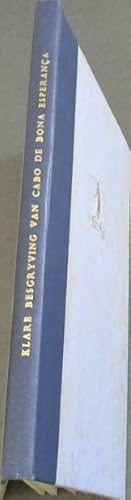
A Clear Description of the Cape Of Good Hope / Klare Besgryving Van Cabo De Bona Esperanca / Facsimile of the text compiled by Jodocus Hondius and Published by Him at Amsterdam in 1652. With an English Translation By L.C.Van Oord and Introduction and Notes By Prof. P. Serton (With three plates and one map)
Published by Book Exhibition Committee Van Riebeeck Festival, 1952
Hardcover. Condition: Good. English and Afrikaans text. There is gilt on the spine and the front of the book. The boards are a little shelf rubbed and edge worn. There is sporadic foxing on the wrap and on the early pages and slightly around the block of the book, but very little in the body of the book. The binding is excellent. GK. Our orders are shipped using tracked courier delivery services.
-
PAP. Condition: New. New Book. Shipped from UK. THIS BOOK IS PRINTED ON DEMAND. Established seller since 2000.
-
PAP. Condition: New. New Book. Shipped from UK. THIS BOOK IS PRINTED ON DEMAND. Established seller since 2000.