Howdell Thomas (4 results)

Published by printed for John Bowles, Robert Sayer, Thos. Jefferys, Carington Bowles and Henry Parker, London 1768
- Art Print
Seller: Donald A. Heald Rare Books (ABAA), New York, U.S.A.Donald A. Heald Rare Books (ABAA)
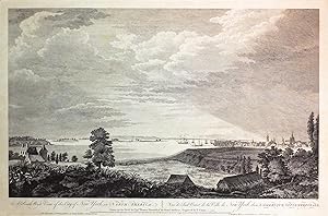
Contact seller5-star sellerAn engraved view by Canot after Howdell. Sheet sizes: 19 1/4 x 26 1/8 inches. The famed Howdell-Canot South West view of New York. Published following the conclusion of the French and Indian War, and in a period of great public interest in the American colonies, the Scenographia Americana was the first book dedicated to a large-…scale artistic depiction of the American landscape. From the Gulf of St. Lawrence to the West indies, the scenes include locations of battles, views of strategic provincial capitals, and newly secured areas of commercial importance. Just as clear is the celebration of nature's 'astonishingly great' expanse, to cite Pownall, great in width and in height. Little is known of Howdell's life other than the outline of his military career. His name first appears in the Army Lists in 1747 and continues until 1771. In 1763 he commanded the seventh company of the third battalion of the Royal Artillery, stationed in New York. He produced this view of the city published in the Scenographia Americana. This southwest view is from Mount Pitt which shows the Rutgers house built in 1754-5, looking across the harbour to the roofs of the city with Trinity Church and the New (or Middle) Dutch Church prominent on the skyline. The dating of this issue, with the added imprint, is ascribed from the mid-1760s to as late as 1774, i.e. after Carington Bowles took over the business in St. Paul's Churchyard but before Sayer began trading as Sayer & Bennett. Deak 116; Stokes Iconography I. pp. 295-296 (plate 38).
 More images
Published by printed for John Bowles, Robert Sayer, Thos. Jefferys, Carington Bowles and Henry Parker, London 1768
- Art Print
Seller: Donald A. Heald Rare Books (ABAA), New York, U.S.A.Donald A. Heald Rare Books (ABAA)
Contact seller5-star sellerAn engraved view by Canot after Howdell. Sheet size: 19 1/4 x 26 1/8 inches. The famed Howdell-Canot South East view of New York. Published following the conclusion of the French and Indian War, and in a period of great public interest in the American colonies, the Scenographia Americana was the first book dedicated to a large-s…cale artistic depiction of the American landscape. From the Gulf of St. Lawrence to the West indies, the scenes include locations of battles, views of strategic provincial capitals, and newly secured areas of commercial importance. Just as clear is the celebration of nature's 'astonishingly great' expanse, to cite Pownall, great in width and in height. Little is known of Howdell's life other than the outline of his military career. His name first appears in the Army Lists in 1747 and continues until 1771. In 1763 he commanded the seventh company of the third battalion of the Royal Artillery, stationed in New York. He produced this view of the city published in the Scenographia Americana. The southeast view from shows a young "gentlemen in fashionable eighteenth-century garb . idling on the rolling slopes of a still bucolic Manhattan . The two buildings on the extreme left of the view are St. George's Church, on Beekman Street, and the jail. The large building in the center of the view is King's College (now Columbia University); the church behind it, at the right, is Trinity. The five prominent buildings between the tall, leafy [`Palm'] tree and King's College are, from left to right, the New (later Middle) Dutch Church, the French Church, the South Dutch Church, the City Hall, and the Presbyterian Church on Wall Street. Behind the more distant of the two fences appear the palisades built in 1745. At the right of the view, the westernmost block-house and gate that protected this line of fortifications can be seen. The large building between the blockhouse and Trinity is probably Vauxhall" (Deak). The dating of this issue, with the added imprint, is ascribed from the mid-1760s to as late as 1774, i.e. after Carington Bowles took over the business in St. Paul's Churchyard but before Sayer began trading as Sayer & Bennett. Deak 115; Stokes Iconography I. pp. 279-281 (plate 37).

Published by London: John Bowles, 1768 1768
Seller: Arader Galleries - AraderNYC, New York, U.S.A.Arader Galleries - AraderNYC
Contact seller5-star sellerEngraved by P.C. Canot (1710 - 1777) 16 x 21 ½ inches sheet, 18 ¾ x 24 ½ inches framed. Engraving on paper (fading and toning consistent with age). Title in English and French on lower margin. Annotation identifying Howdell as artist and Canot as engraver below. Plate legend on lower margin identifying well-known sites such as S…taten Island, Long Island, and South River. This rare and splendid view of early New York was drawn on the spot by Captain Thomas Howdell of the British Royal Artillery shortly before the start of the American Revolution, and engraved by the masterful Pierre-Charles Canot of England. The scene depicted is taken from the southern slope of Mount Pitt, which is near the intersection of today's Henry and Montgomery streets on the Lower East Side of New York. This view serves as an important historical record of New York's early growth and appearance just prior to the American Revolution. In the far left foreground we see two buildings of the Rutgers house, which was built in 1754-5. The meadow south of the Rutgers house, with its rich and lush foliage, is a prominent feature in many of the views and plans of the period. The middle ground shows ships sailing serenely across a ribbon of water. Across the harbor, on the far right of the composition, we see the roofs of the city with Trinity Church and the New (or Middle) Dutch Church prominent on the skyline. The numbered key (1-7) in the lower margin guides the viewer to important early sites around New York, such as the harbor, Nutting Island, Staten Island, Long Island, South River, and Brew-house. Brooklyn is also visible in the far left. This fascinating glimpse of New York City, which then comprised little more than the very southernmost tip of Manhattan Island, is a very rare view dating from this crucial period. The land of New York was discovered in 1524, and colonized by the Dutch in 1624, when it was named New Amsterdam and became a trading port of the Dutch West India Company. In 1664 this Dutch colony was surrendered to British forces and renamed New York after James Duke of York (1633-1701), who had been granted the land by his brother King Charles II. Within fifteen years of this present view, New York would become one of the most important cities in the new nation. Today it is a vibrant and diverse beacon of culture, finance, and education for the world. Catalogued by Xueli Wang, Columbia University, BA; Courtauld Institute of Art, MA. You are warmly invited to visit our gallery at 1016 Madison Avenue in New York City to view this work whenever it might be convenient.
Published by London: John Bowles, 1768 1768
Seller: Arader Galleries - AraderNYC, New York, U.S.A.Arader Galleries - AraderNYC
Contact seller5-star sellerEngraved by P.C. Canot (1710 - 1777) 16 x 21 ½ inches sheet, 18 ¾ x 24 ½ inches framed. Engraving on paper (fading and toning consistent with age). Title in English and French on lower margin. Annotation identifying Howdell as artist and Canot as engraver below. Plate legend on lower margin identifying well-known sites such as t…he North River (Hudson River), City Hall, and Staten Island. This rare and splendid view of early New York was drawn on the spot by Captain Thomas Howdell of the British Royal Artillery shortly before the start of the American Revolution, and engraved by the masterful Pierre-Charles Canot of England. The scene is taken from near today's corner of Varick and Beach streets in lower Manhattan. The main building shown is King's College, now known as Columbia University. Here, the city appears as little more than a village beyond the rolling hills and fields in the foreground, and this view serves as an important historical record of New York's early growth and appearance just prior to the American Revolution. In the very foreground we see two colonial-era figures sitting surrounded by rich and lush foliage. Church spires punctuate the skyline further back, while in the distance, the shore of Staten Island, then quite sparsely settled, is just visible on the horizon. The monuments Howdell depicted include (from east to west) St. George's Church, the jail, the New Dutch Church, the French Church, the South Dutch Church, City Hall, the Presbyterian Church on Wall Street, King's College (with a cupola), and Trinity Church. This fascinating glimpse of New York City, which then comprised little more than the very southernmost tip of Manhattan Island, is a very rare view dating from this crucial period. The land of New York was discovered in 1524, and colonized by the Dutch in 1624, when it was named New Amsterdam and became a trading port of the Dutch West India Company. In 1664 this Dutch colony was surrendered to British forces and was renamed New York after James Duke of York (1633-1701), who had been granted the land by his brother King Charles II. Within fifteen years of this present view, New York would become one of the most important cities in the new nation. Today it is a vibrant and diverse beacon of culture, finance, and education for the world. Catalogued by Xueli Wang, Columbia University, BA; Courtauld Institute of Art, MA. You are warmly invited to visit our gallery at 1016 Madison Avenue in New York City to view this work whenever it might be convenient.


