Order Total (1 Item Items):
Shipping Destination:

Joseph G Bruff (1 results)
Skip to main search results
Search filters
Product Type
- All Product Types
- Books (1)
- Magazines & Periodicals (No further results match this refinement)
- Comics (No further results match this refinement)
- Sheet Music (No further results match this refinement)
- Art, Prints & Posters (No further results match this refinement)
- Photographs (No further results match this refinement)
- Maps (No further results match this refinement)
- Manuscripts & Paper Collectibles (No further results match this refinement)
Condition Learn more
- New (No further results match this refinement)
- As New, Fine or Near Fine (No further results match this refinement)
- Very Good or Good (No further results match this refinement)
- Fair or Poor (No further results match this refinement)
- As Described (1)
Binding
- All Bindings
- Hardcover (1)
- Softcover (No further results match this refinement)
Collectible Attributes
- First Edition (No further results match this refinement)
- Signed (No further results match this refinement)
- Dust Jacket (No further results match this refinement)
- Seller-Supplied Images (1)
- Not Print on Demand (1)
Language (1)
Price
- Any Price
- Under US$ 25 (No further results match this refinement)
- US$ 25 to US$ 50 (No further results match this refinement)
- Over US$ 50
Free Shipping
- Free Shipping to U.S.A. (No further results match this refinement)
Seller Location
Seller Rating
-
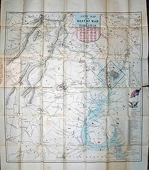
Army Map of the Seat of War in Virginia, SHowing the Battle Fields, Fortifications, etc. on & Near the Potomac River
Published by New York & Washington, New York & Washington, 1862
Seller: High Ridge Books, Inc. - ABAA, South Deerfield, MA, U.S.A.
Association Member: ABAA ESA ILAB SNEAB
Seller rating 5 out of 5 stars

Folding map in original gilt-stamped cloth folder. Fine condition. The map has a couple of short splits along folds at edges and a short tear where attached to binding, otherwise fine condition. Some hand-color, including cartouche, bodies of water, and location of troops at battles. Small colored American flags indicate Union positions. Shows from Baltimore in the northeast corner to Fredericksburg, Virginia at the southern edge, Culpepper Courthouse in the west. 34 Union forts, largely in Washington D.C. or along the Potomac, are identified in a key at the lower right. This is likely the last of three states of this map. Two of these are identified in Stephenson (1861 and early 1862) but this issue, which shows the Second Battle of Bull Run just west of Germantown and Fairfax Courthouse and adds other new details in the vicinity of that battle, is not mentioned. Neither of the two images of examples of the 1862 issue (Stephenson 455) shown by the Library of Congress contain this added information. Rumsey 2846 does not have this added material either. Published in New York by John Disturnell and Washington D.C. by Hudson Taylor. This is a rare, and very attractive, map of the theater of war in Northern Virginia.