Map Dower (30 results)

Language: English
Published by GEORGE VIRTUE, Edinburgh 1837
- Hardcover
- First Edition
Seller: K Books Ltd ABA ILAB, York, YORKS, United KingdomK Books Ltd ABA ILAB
Contact seller5-star sellerCondition: Used - Very good
US$ 17.83
US$ 26.16 shippingShips from United Kingdom to U.S.A.Quantity: 1 available
Single Sheet Engraving. Condition: Very Good. No Jacket. First Edition. AUSTRALIA, AN ANTIQUE MAP, CIRCA 1860 A VERY GOOD MAP . VERY REASONABLY PRICED, . MEASURES 10 X 8 INCHES, 30 X 22 CMS, WELL PACKED MOUNTED AND READY TO FRAME, SEEMS VERY FEW TOWNS MENTIONED OTHE THAN ROUND THE COAST, VERY GOOD CONDITION, SPLENDID VALUE. J DO…WER (illustrator).
Language: English
Published by London 1860
Seller: K Books Ltd ABA ILAB, York, YORKS, United KingdomK Books Ltd ABA ILAB
Contact seller5-star sellerCondition: Used - Very good
US$ 27.63
US$ 26.16 shippingShips from United Kingdom to U.S.A.Quantity: 1 available
No Binding. Condition: Very Good. A splendid original antique coloured Map . Mounted - matted - and ready to frame. Very good condition . Somewhat uncommon . A fine detailed map showing Egypt with 2 fine coloured vignettes of Cairo , drawn and engraved by L Dower. Dower, L (illustrator).
Language: English
Published by CASSELL. PETTER & GALPIN, London 1865
Seller: K Books Ltd ABA ILAB, York, YORKS, United KingdomK Books Ltd ABA ILAB
Contact seller5-star sellerCondition: Used - Very good
US$ 27.63
US$ 26.16 shippingShips from United Kingdom to U.S.A.Quantity: 1 available
No Binding. Condition: Very Good. A very detailed original antique map drawn by John Dower FRGS. no date of publication but with details of the MPs returned by the Division of Northamptonshire, coloured in outline, slight foxing at edges - impressive and reasonably priced. John DOWER (illustrator).
Language: English
Published by CASSELL. PETTER & GALPIN, London 1865
Seller: K Books Ltd ABA ILAB, York, YORKS, United KingdomK Books Ltd ABA ILAB
Contact seller5-star sellerCondition: Used - Very good
US$ 27.63
US$ 26.16 shippingShips from United Kingdom to U.S.A.Quantity: 1 available
No Binding. Condition: Very Good. A very detailed original antique map drawn by John Dower FRGS. no date of publication but with a lot of information about the Southern Division of Northamptonshire and its population based on the 1861 census and with crime statistics dated 1862, coloured in outline, slight foxing at edges - impr…essive and reasonably priced. Bottom righthand corner torn with loss affecting bottom border of map only. John DOWER (illustrator).
Language: English
Published by CASSELL. PETTER & GALPIN, London 1865
Seller: K Books Ltd ABA ILAB, York, YORKS, United KingdomK Books Ltd ABA ILAB
Contact seller5-star sellerCondition: Used - Very good
US$ 27.63
US$ 26.16 shippingShips from United Kingdom to U.S.A.Quantity: 1 available
No Binding. Condition: Very Good. A very detailed original antique map drawn by John Dower FRGS. no date of publication but with a lot of information about Norfolk and its population based on the 1861 census and with crime statistics dated 1862, coloured in outline, slight foxing at edges - impressive and reasonably priced. John… DOWER (illustrator).

Published by Orr & Comp Amen Corner Paternoster Row Ca1870 1870
Seller: PROCTOR / THE ANTIQUE MAP & BOOKSHOP, DORCHESTER, United KingdomPROCTOR / THE ANTIQUE MAP & BOOKSHOP
Contact seller5-star sellerCondition: Used
US$ 17.96
US$ 26.83 shippingShips from United Kingdom to U.S.A.Quantity: 1 available
Size of engraved surface: 25cm x 30cm. In very good condition. Red pen markings on map. Uncoloured.

Published by Orr & Comp Amen Corner Paternoster Row Ca1870 1870
Seller: PROCTOR / THE ANTIQUE MAP & BOOKSHOP, DORCHESTER, United KingdomPROCTOR / THE ANTIQUE MAP & BOOKSHOP
Contact seller5-star sellerCondition: Used
US$ 23.49
US$ 26.83 shippingShips from United Kingdom to U.S.A.Quantity: 1 available
Size of engraved surface: 25cm x 30cm. In very good condition. Water stain on left hand side. Pencil markings on map and coloured underlining. Uncoloured.

Published by Orr & Comp Amen Corner Paternoster Row Ca1870 1870
Seller: PROCTOR / THE ANTIQUE MAP & BOOKSHOP, DORCHESTER, United KingdomPROCTOR / THE ANTIQUE MAP & BOOKSHOP
Contact seller5-star sellerCondition: Used
US$ 30.40
US$ 26.83 shippingShips from United Kingdom to U.S.A.Quantity: 1 available
Size of engraved surface: 25cm x 30cm. In very good condition. Some faint mark on edge. Some coloured underlining Uncoloured.
Published by Orr & Comp Amen Corner Paternoster Row Ca1870 1870
Seller: PROCTOR / THE ANTIQUE MAP & BOOKSHOP, DORCHESTER, United KingdomPROCTOR / THE ANTIQUE MAP & BOOKSHOP
Contact seller5-star sellerCondition: Used
US$ 30.40
US$ 26.83 shippingShips from United Kingdom to U.S.A.Quantity: 1 available
Size of engraved surface: 25cm x 30cm. In very good condition. Faint marks on bottom left corner. Some coloured underlining Uncoloured.
 More images
Published by Orr & Comp Amen Corner Paternoster Row Ca1870 1870
Seller: PROCTOR / THE ANTIQUE MAP & BOOKSHOP, DORCHESTER, United KingdomPROCTOR / THE ANTIQUE MAP & BOOKSHOP
Contact seller5-star sellerCondition: Used
US$ 30.40
US$ 26.83 shippingShips from United Kingdom to U.S.A.Quantity: 1 available
Size of engraved surface: 25cm x 30cm. In very good condition. Some coloured underlining Uncoloured.

Published by Orr & Comp Amen Corner Paternoster Row Ca1870 1870
Seller: PROCTOR / THE ANTIQUE MAP & BOOKSHOP, DORCHESTER, United KingdomPROCTOR / THE ANTIQUE MAP & BOOKSHOP
Contact seller5-star sellerCondition: Used
US$ 30.40
US$ 26.83 shippingShips from United Kingdom to U.S.A.Quantity: 1 available
Size of engraved surface: 25cm x 30cm. In very good condition. Some faint marks on left hand edge. Some pencil markings and coloured underlining Uncoloured.

Published by Orr & Comp Amen Corner Paternoster Row Ca1870 1870
Seller: PROCTOR / THE ANTIQUE MAP & BOOKSHOP, DORCHESTER, United KingdomPROCTOR / THE ANTIQUE MAP & BOOKSHOP
Contact seller5-star sellerCondition: Used
US$ 30.40
US$ 26.83 shippingShips from United Kingdom to U.S.A.Quantity: 1 available
Size of engraved surface: 25cm x 30cm. In very good condition. Slight stain on outer edge of left hand side. Uncoloured.

Published by Orr & Comp Amen Corner Paternoster Row Ca1870 1870
Seller: PROCTOR / THE ANTIQUE MAP & BOOKSHOP, DORCHESTER, United KingdomPROCTOR / THE ANTIQUE MAP & BOOKSHOP
Contact seller5-star sellerCondition: Used
US$ 30.40
US$ 26.83 shippingShips from United Kingdom to U.S.A.Quantity: 1 available
Size of engraved surface: 25cm x 30cm. In very good condition. Uncoloured.

Published by Orr & Comp Amen Corner Paternoster Row Ca1870 1870
Seller: PROCTOR / THE ANTIQUE MAP & BOOKSHOP, DORCHESTER, United KingdomPROCTOR / THE ANTIQUE MAP & BOOKSHOP
Contact seller5-star sellerCondition: Used
US$ 38.69
US$ 26.83 shippingShips from United Kingdom to U.S.A.Quantity: 1 available
Size of engraved surface: 25cm x 30cm. In very good condition. Some coloured underlining. Uncoloured.

Published by Orr & Comp Amen Corner Paternoster Row Ca1870 1870
Seller: PROCTOR / THE ANTIQUE MAP & BOOKSHOP, DORCHESTER, United KingdomPROCTOR / THE ANTIQUE MAP & BOOKSHOP
Contact seller5-star sellerCondition: Used
US$ 38.69
US$ 26.83 shippingShips from United Kingdom to U.S.A.Quantity: 1 available
Size of engraved surface: 25cm x 30cm. In very good condition. Some faint mark on edges. Some pencil markings and coloured underlining Uncoloured.

Published by Orr & Comp Amen Corner Paternoster Row Ca1870 1870
Seller: PROCTOR / THE ANTIQUE MAP & BOOKSHOP, DORCHESTER, United KingdomPROCTOR / THE ANTIQUE MAP & BOOKSHOP
Contact seller5-star sellerCondition: Used
US$ 38.69
US$ 26.83 shippingShips from United Kingdom to U.S.A.Quantity: 1 available
Size of engraved surface: 25cm x 30cm. In very good condition. Small pencil text by Ceylon. Some pencil marks and coloured underlining Uncoloured.

Published by Orr & Comp Amen Corner Paternoster Row Ca1870 1870
Seller: PROCTOR / THE ANTIQUE MAP & BOOKSHOP, DORCHESTER, United KingdomPROCTOR / THE ANTIQUE MAP & BOOKSHOP
Contact seller5-star sellerCondition: Used
US$ 38.69
US$ 26.83 shippingShips from United Kingdom to U.S.A.Quantity: 1 available
Size of engraved surface: 25cm x 30cm. In very good condition. Faint mark top left corner. Uncoloured.

Published by Orr & Comp Amen Corner Paternoster Row Ca1870 1870
Seller: PROCTOR / THE ANTIQUE MAP & BOOKSHOP, DORCHESTER, United KingdomPROCTOR / THE ANTIQUE MAP & BOOKSHOP
Contact seller5-star sellerCondition: Used
US$ 42.83
US$ 26.83 shippingShips from United Kingdom to U.S.A.Quantity: 1 available
Size of engraved surface: 25cm x 30cm. In very good condition. Some faint marks on left hand edge. Mark to top right hand corner. Some coloured underlining Uncoloured.
 More images
Published by Orr & Comp Amen Corner Paternoster Row Ca1870 1870
Seller: PROCTOR / THE ANTIQUE MAP & BOOKSHOP, DORCHESTER, United KingdomPROCTOR / THE ANTIQUE MAP & BOOKSHOP
Contact seller5-star sellerCondition: Used
US$ 45.59
US$ 26.83 shippingShips from United Kingdom to U.S.A.Quantity: 1 available
Size of engraved surface: 25cm x 30cm. In very good condition. Darkening around edge. Small mark on bottom edge. Pencil text to bottom right corner. Some coloured underlining Coloured.
 More images
Published by London: Published by William Orr [n.d., c. 1850's]. 1850
- Hardcover
- Map
Seller: Spike Hughes Rare Books ABA, Innerleithen, , United KingdomSpike Hughes Rare Books ABA
Contact seller5-star sellerCondition: Used
US$ 75.99
US$ 34.88 shippingShips from United Kingdom to U.S.A.Quantity: 1 available
Engraved hand-coloured map, overall size 275 X 230 mm., in sections, mounted on linen and folding into orig. cloth cover, gilt title 'Scotland' on upper cover. [The only record we can find on this map is one issued as part of Dower's 'Library atlas of physical and political georgraphy.' issued c. 1854. This has the map number 'V…II' on the top left. The above copy has no number and would appear to be a separate issue.
 More images
Published by Orr & Comp Amen Corner Paternoster Row Ca1870 1870
Seller: PROCTOR / THE ANTIQUE MAP & BOOKSHOP, DORCHESTER, United KingdomPROCTOR / THE ANTIQUE MAP & BOOKSHOP
Contact seller5-star sellerCondition: Used
US$ 48.36
US$ 26.83 shippingShips from United Kingdom to U.S.A.Quantity: 1 available
Size of engraved surface: 25cm x 30cm. In very good condition. Faint mark lower right corner. Uncoloured.

Published by Orr & Comp Amen Corner Paternoster Row Ca1870 1870
Seller: PROCTOR / THE ANTIQUE MAP & BOOKSHOP, DORCHESTER, United KingdomPROCTOR / THE ANTIQUE MAP & BOOKSHOP
Contact seller5-star sellerCondition: Used
US$ 53.88
US$ 26.83 shippingShips from United Kingdom to U.S.A.Quantity: 1 available
Size of engraved surface: 25cm x 30cm. In very good condition. Smudge by map title. Inscription to rear dated 1872. Uncoloured.

Published by Henry Teesdale & Co. (1836)., London. 1836
- Hardcover
Seller: Asia Bookroom ANZAAB/ILAB, Canberra, ACT, AustraliaAsia Bookroom ANZAAB/ILAB
Contact seller5-star sellerCondition: Used
US$ 181.47
US$ 21.25 shippingShips from Australia to U.S.A.Quantity: 1 available
Engraved map coloured in outline, 33.7 x 41.5 cms; 38.7 x 48 cms (sheet including platemark), relief shown by hachures, central fold, all edges gilt, in very good condition. An very attractive map prepared for Teesdale's "A New General Atlas of the World.".

- Map
Seller: Geographicus Rare Antique Maps, Brooklyn, NY, U.S.A.Geographicus Rare Antique Maps
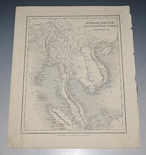
Contact seller4-star sellerGood. Wear along original centerfold. Verso repairs to centerfold separations. Size 14.25 x 13.75 Inches. This is a beautifully colored 1831 Henry Teesdale / John Dower map of the Western Hemisphere published in their A New General Atlas of the World . The map predates the Mexican-American War, thus the United States does not in…clude the modern-day American Southwest or Texas. A Closer Look North, Central, and South America immediately draw the viewer's attention. Cities are identified, including Quebec, Montreal, New York, Boston, Charleston, New Orleans, Veracruz, Havana, Caracas, Montevideo, Buenos Aires, Rio de Janeiro, and Valparaiso. Bays, capes, and other coastal features are labeled throughout. Islands are illustrated across the Pacific, such as Christmas Island and Owhyhee (Hawaii). Karakakooa Bay is marked as the site of Captain Cook's death on February 14, 1779. Lines trace Cook's voyages in the Atlantic and Pacific, with specific dates noted at a handful of positions. Publication History and Census Although not indicated on the sheet, this map was engraved by John Dower as the second plate in the 1831 edition of A New General Atlas of the World , published by Henry Teesdale. This appears to be a rare presentation of this map, as most examples from any edition of the atlas do not show such vivid and full color, only hand-colored outlines of territories. The 1831 edition of this map is independently cataloged in OCLC as being part of the holdings at the University of Chicago, the University of Texas at Arlington, the University of California Los Angeles, the Anchorage Museum, the University of Oxford, the National Library of New Zealand, and the National Library of Australia. The entire atlas is held by roughly one dozen institutions. References: OCLC 43222767.

- Map
Seller: Geographicus Rare Antique Maps, Brooklyn, NY, U.S.A.Geographicus Rare Antique Maps
Contact seller4-star sellerVery good. Some discoloration along fold line and in margins. Size 13 x 16 Inches. This is the Henry Teesdale / John Dower 1831 map of Peru and Bolivia published in A New General Atlas of the World . It depicts the titular countries and their neighbors as they emerged from Spanish rule and contended with internal and external co…nflicts over borders, social structures, and systems of government. Historical Context This map was published in the years after Peru, Bolivia, and other South American republics won their independence, following a long and difficult conflict with the Spanish crown. But the constitution of the new republics, their political representation, and their borders were far from fixed, leading to further conflict. Just three years before this map's publication, Peru fought a border war against Bolivia, a prelude to a larger war with Colombia (Gran Colombia), which resulted in the latter state's dissolution and the dramatic fall of Simón Bolívar. In the late 1830s, attempts were made to unite Peru and Bolivia through both peaceful and forceful means. In the late 1870s, the two former rivals teamed up in yet another border dispute against Chile. The present-day borders differ somewhat from what is illustrated here. For instance, Bolivia's border with Peru now runs through and to either side of Lake Titicaca (Chucuito), while the border between Peru and Chile now sits between Tacna and Arica, both part of Peru here. Domestic politics were just as contentious, with uncertainty over the system of government to be adopted, the relative strength of different branches of government, the role of the military, and the social groups whose interests the government would represent. Indigenous (Indian) communities, who composed most of the population in Bolivia and certain areas of Peru, were at best neglected and at worst oppressed by the new republics, despite the hopes of Bolívar to improve their lot. Neighboring countries went through similar transformations; 'La Plata' at bottom refers to the United Provinces of the Río de la Plata, the confederation that Bolivia had earlier belonged to, and whose remnant parts merged the same year as this map's publication to form Argentina. Publication History and Census This map was engraved by John Dower for the 1831 edition of A New General Atlas of the World , published by Henry Teesdale. This appears to be an especially rare presentation of Dower's Peru and Bolivia map, not matching any of the examples in the David Rumsey Historical Map Collection or other major digital repositories. Although undated, based on contextual evidence (such as the inclusion of La Plata), it almost certainly is an example from 1831. The map is only cataloged in the holdings of five institutions, though as stated above the present map is likely to be distinct from those examples in coloration and presentation. References: OCLC 43221802.

- Map
Seller: Geographicus Rare Antique Maps, Brooklyn, NY, U.S.A.Geographicus Rare Antique Maps
Contact seller4-star sellerGood. Discoloration along the central fold line. Size 12.5 x 15.5 Inches. This is a brilliantly colored 1831 Henry Teesdale / John Dower map of the 'Turkey in Asia,' that is, the Asian portion of the Ottoman Empire. This map was published as the Ottoman Empire faced both external and internal threats, and an acute existential cr…isis from within at the hands of Muhammed Ali Pasha, which the dynasty only survived thanks to a foreign intervention. A Closer Look This map illustrates the Ottoman Empire in Asia, which by the time this map was produced was most of what remained of the empire, as the Ottomans had lost much of their territory in southeastern Europe to nationalist independence movements. Declining Ottoman authority, social discontent, and rising nationalist sentiment also caused Istanbul to lose control of Egypt (discussed below) and to retain only a weak grip over much of the Levant. These vulnerabilities would be exploited repeatedly by Britain, France, and Russia, who were only limited by a desire not to see each other gain too strong of a foothold in the Levant. Decline of the Ottoman Empire and the Rise of Muhammed Ali Pasha Throughout the 19th century, the Ottoman Empire was beset not only by external threats (a string of wars against Russia in particular) but also by internal division. National awakenings in the Balkans at the start of the 19th century had forced Istanbul to relinquish control over Serbia and to fight a losing battle to retain Greece. Meanwhile, and not for the first time in Ottoman history, a dynamic administrator and military commander proved to be a double-edged sword. Muhammed Ali Pasha initially came to power in Egypt after being dispatched by the Ottomans to restore their authority there, which had been overturned by Napoleon's invasion in 1798 and a subsequent civil war. He was successful in pacifying Egypt, but then immediately moved to declare himself ruler of the province and instituted a range of modernizing reforms. Muhammed Ali was a powerful weapon for the Ottomans, conquering Sudan, reconquering Arabia, and nearly reconquering Greece until he was stymied by a combined British, French, and Russian intervention at Navarino in 1827, which sank his entire navy. However, he was also ambitious and beyond the control of Istanbul (which explains Egypt not being included among Ottoman lands here). In exchange for his military campaigns, Muhammed Ali demanded that the Sultan grant him control of Syria. When that demand was rejected, the same year this map was published, Muhammad Ali launched an invasion of Syria, handily defeating Ottoman forces before moving further into Anatolia. The Ottomans were only saved through the intervention of Russia, which blocked the route to Istanbul. Thereafter, Britain and France brokered an agreement that capped Russia's influence in Turkey (their primary concern) while mollifying Muhammed Ali by granting him Syria. Less than a decade later, the Egyptians and Ottomans waged war again, with Muhammed Ali again winning handily and again being prevented from capturing Istanbul by an intervention of major European powers. However, he was effectively granted de jure autonomy over Egypt, establishing an independent dynasty, in exchange for leaving Ottoman Syria. Unfortunately for Muhammed Ali, his successors were not nearly as capable or wily as he, and the dynasty's power waned vis-à-vis European powers, with Egypt falling under British occupation and then a protectorate in the late 19th - early 20th century. Publication History and Census This map was engraved by John Dower for the 1831 edition of A New General Atlas of the World , published by Henry Teesdale. This appears to be an especially rare presentation of this map, as examples in the David Rumsey Historical Map Collection and other major digital repositories from other editions of the map do not show such vivid and full color. The 1831 edition of this map is only independently cataloged in the holdings o.

- Map
Seller: Geographicus Rare Antique Maps, Brooklyn, NY, U.S.A.Geographicus Rare Antique Maps
Contact seller4-star sellerVery good. Size 15.25 x 12.75 Inches. This is a stunning example of the 1831 John Dower and Henry Teesdale map of Brazil and Guyana published in their A New General Atlas of the World . It depicts the region as it emerged from wars of independence against Spain and Portugal, when both borders and political systems were in flux.…A Closer Look This map illustrates the Empire of Brazil at its greatest extent, roughly a decade after independence from Portugal, along with the Guianas, including British, French, and Dutch colonies. Lands north of the Amazon that were inland from the coast (Guiana), shown here as part of Brazil, were contested between several powers, and were only definitely recognized as Brazilian territory in the early 20th century. Aside from cities and political divisions, mountains are also indicated with hachures, while rivers and coastal features (bays, bars, islands) are assiduously noted. In the Amazon, the names of local indigenous groups are also indicated. Scales are provided in both British miles and Portuguese leagues. The information presented here was a bit out of date, as Uruguay is here included in Brazil as 'Banda Oriental.' In fact, the territory had its independence recognized in the Treaty of Montevideo in August 1828, following twelve years of Brazilian occupation and warfare (neighboring Paraguay would likewise see a protracted independence struggle against Brazil in the 1860s 1870s). Independence and Struggle in Brazil After several attempted revolts, Brazil succeeded in gaining its independence from Portugal in 1822, a movement that, perhaps unexpectedly, was led by the son of the Portuguese King João VI. However, the country's early years saw a string of revolts and wars, as various social groups and newly independent countries jockeyed for power. Brazil's major opponent was the United Provinces of the Río de la Plata, a predecessor to the Republic of Argentina. In this era, much of the country remained sparsely populated despite continued immigration and a significant portion of the economy relied on slavery and plantation agriculture, though modern industries were developed in the second half of the 19th century. Publication History and Census This map was engraved by John Dower for the 1831 edition of A New General Atlas of the World , published by Henry Teesdale. This appears to be an especially rare presentation of this map, as most examples from this or other editions of A New General Atlas do not show such vivid and full hand-coloring, only the outlines of territories. The 1831 edition of this map is only independently cataloged in the holdings of four institutions, while the entire atlas is held by roughly a dozen institutions, though as stated above the present map may be distinct from those examples in coloration. References: OCLC 43221863.

- Map
Seller: Geographicus Rare Antique Maps, Brooklyn, NY, U.S.A.Geographicus Rare Antique Maps
Contact seller4-star sellerVery good. Light wear and toning along original centerfold. Light soiling. Size 13.5 x 16.25 Inches. This is an 1831 John Dower and Henry Teesdale map of southern Italy, then known as the Kingdom of the Two Sicilies. A Closer Look Depicting from Rome to Cape Passaro in southern Sicily, provinces are shaded for differentiation. C…ities and towns are labeled throughout, including Rome, Naples, Salerno, Brindisi, Messina, Palermo, and Syracuse. Capes, bays, and other coastal landmarks are also identified. An inset along the left border details Sardinia. The Kingdom of the Two Sicilies The Kingdom of the Two Sicilies, formed when the Naples merged with Sicily, existed from 1816 until 1860. Giuseppe Garibaldi overthrew the King of the Two Sicilies in 1860, then the people voted to join the Savoyard Kingdom of Sardinia in a plebiscite. Publication History and Census This map was drawn and engraved by John Dower for the 1831 edition of A New General Atlas of the World , published by Henry Teesdale. We note a single cataloged example of the 1831 edition of the separate map in OCLC which is part of the collection at the University of Oxford. References: OCLC 43212482.

- Map
Seller: Geographicus Rare Antique Maps, Brooklyn, NY, U.S.A.Geographicus Rare Antique Maps
Contact seller4-star sellerVery good. Some toning and some wear along the central fold line. Size 15.25 x 12.5 Inches. This is a brilliantly colored 1831 Henry Teesdale / John Dower map of Van Diemen's Land (Tasmania) published in their A New General Atlas of the World . It depicts the territory at a time when it primarily served as a British penal colony…, gaining it a notorious reputation as an inhospitable and undesirable place. A Closer Look This map was made as British colonial presence on Tasmania and surrounding islands was increasing. Beginning from a small military outpost, established in 1803 to prevent the French claims, the island's population grew quickly, including free settlers and thousands of convicts bound for labor in the households of free settlers and in factories, penal stations, and prisons. Some of these prisons were especially desolate and brutal places, where violence was commonplace. If and when they were released, former convicts generally left the island as soon as possible, with most resettling in Victoria. In the meantime, the indigenous population of Tasmania had been drastically reduced by disease and warfare, from several thousand to around 300 by the time this map was published. As is evident here, knowledge of the interior, especially the western half, was limited. Many areas are described simply, such as 'emu plain,' ' peak like a volcano,' 'sandy,' and 'forest.' Two settlements of considerable size developed at Hobart Town (now Hobart) and Launceston, and penal labor was employed to build up public works, such as roads, government buildings, and prisons. In 1853, penal transportation to the island ceased, and soon afterward it adopted a constitution and changed its name to Tasmania. Publication History and Census This map was engraved by John Dower for the 1831 edition of A New General Atlas of the World , published by Henry Teesdale. This appears to be an especially rare presentation of this map, as most examples do not show such vivid and full color, only hand-colored outlines of territories (the example held by the National Library of Australia is an exception). The 1831 edition of this map is only independently cataloged in the holdings of six institutions, while the entire atlas is held by roughly a dozen institutions, though as stated above the present map is likely distinct from those examples in coloration. References: OCLC 43218176, 221454834.


