Map Laos (6 results)
 More images
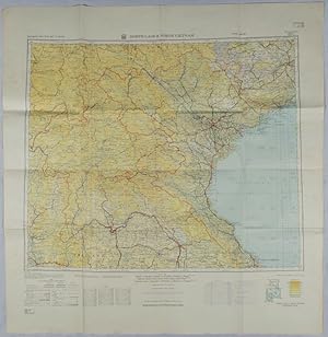
Published by Rand McNally. circa1970., [Chicago]. 1970
Seller: Asia Bookroom ANZAAB/ILAB, Canberra, ACT, AustraliaAsia Bookroom ANZAAB/ILAB
Contact seller5-star sellerCondition: Used
US$ 54.42
US$ 21.25 shippingShips from Australia to U.S.A.Quantity: 1 available
Very large folding colour map, 136 x 89 cms folding to 30.5 x 22.8 cms, legend and glossary with a gazetteer in an upper corner to North and South Vietnam, Cambodia and Laos, small fold split (no loss), in very good condition. Extremely detailed map of Indochina (scale of 1 inch to approximately 20 miles) with roads, paths, trai…ls, railroads, airports marked and indexes to cities and towns and population totals in South Vietnam, North Vietnam, Cambodia, and Laos. Includes a glossary of foreign terms and a brief gazetteer.
Published by U.S. Army Map Service, Far East., Washington, D.C. 1963
Seller: Asia Bookroom ANZAAB/ILAB, Canberra, ACT, AustraliaAsia Bookroom ANZAAB/ILAB
Contact seller5-star sellerCondition: Used
US$ 181.40
US$ 21.25 shippingShips from Australia to U.S.A.Quantity: 1 available
First Printing. Scale 1:1,250,000 (16°45'N-23°30'N/100°00'E-108°30'E). Lambert conformal conic projection, with standard parallels at 18°05'N and 22°25'N. Occasional foxing, with small crease at upper left corner, 'North Laos & North Viet Nam' lightly pencilled on reverse, a very good copy. 87.0 x 84.6cm. AMS Southeast Asia Road… Map series. Sheet 1 of 4 of mainland Southeast Asia. From the collection of a former pilot active in Southeast Asia during the 1970s. A map of Indochina north of the 17th parallel north, along which roughly ran the Provisional Military Demarcation Line, dividing North and South Vietnam as per the 1954 Geneva Conference.

Published by (Circa1943)., (France). 1943
Seller: Asia Bookroom ANZAAB/ILAB, Canberra, ACT, AustraliaAsia Bookroom ANZAAB/ILAB
Contact seller5-star sellerCondition: Used
US$ 290.23
US$ 21.25 shippingShips from Australia to U.S.A.Quantity: 1 available
Beautiful French pictorial lithograph map, 38 x 28cm. Little loss upper left corner, not affecting image, a little light even toning, but still in very good condition. Attractive brightly coloured map by a French artist whose very attractive but indecipherable signature is printed at the bottom left corner of the map. The artist… also drew maps of several other parts of Indochina.

- Map
Seller: Geographicus Rare Antique Maps, Brooklyn, NY, U.S.A.Geographicus Rare Antique Maps
Contact seller4-star sellerVery good. Light wear along original fold lines. Size 12.25 x 11.25 Inches. A curious c. 1890 Italian-language map of the Burmese Shan States and environs, stretching as far east as Luang Prabang. The title and some historical context strongly suggest that this map was prepared by Italian missionaries of the Pontifical Institute… for Foreign Missions society in the years after the Third Anglo-Burmese War. A Closer Look Coverage ranges from the Sittang River to the Mekong River, coterminous with today's Shan State, along with portions of northern Thailand and Laos. The Salween River forms much of the western boundary of the Shan States at the left, while the Lancang River at the top serves as the border with Yunnan province of China. Mountains, rivers, settlements, and Indigenous groups are labeled throughout. The territory at the bottom-left, near Taungoo, is noted as being the realm of the Red Karens, or Karenni people. A line towards the bottom demarcates the 'Ava' Shans (using the term for the kingdom the Shans conquered in the 16th century) from those who were tributaries of Siam. P.I.M.E. Missionaries in the Shan States This map contains no publication information. We have been unable to identify a source text, if any, but it most likely was produced by Italian missionaries of the Pontifical Institute for Foreign Missions. Italian P.I.M.E. missionaries, led by Eugenio Biffi, Rocco Tornatore, Tancredi Conti, and Sebastiano Carbone, arrived in this region in 1867 and were based at Taungoo. Focusing on the territory east of the Salween River, an area as large as their native Italy but little known to Westerners, they proselytized among the 'tribal' communities (Karen, Shan, etc.) distrusted by both the Burmans and British. Traveling into rugged mountain territory, the missionaries met with limited success but did gain important geographic, linguistic, and cultural knowledge. The Shan States (1885 - 1948) Occupying a large portion of this map, the Shan States were a collection of kingdoms in British Burma and northern Siam. These states had been independent kingdoms for hundreds of years, each with its own agreement to pay tribute to a certain country for protection, either Burma or China. When the British invaded in 1885 (the Third Anglo-Burmese War), this upset the delicate balance and led to years of fighting and insurgency. To this day, the Shan States are in open rebellion against the Myanmar central government. Publication History and Census As mentioned above, this map contains no publication information but was most likely produced by Italian P.I.M.E. missionaries in the late 19th century. We have been unable to identify a source text, if any (the mention of 'Shan States' suggests a date after 1885). We do not find this map in any institutional holdings or historical sales on the market.

Indo-Chine Carte de la Mission Pavie.
1914 'Missions Pavie' General Map of Southeast Asia: Thailand, Cambodia, Laos, Vietnam
- Map
Seller: Geographicus Rare Antique Maps, Brooklyn, NY, U.S.A.Geographicus Rare Antique Maps
Contact seller4-star sellerVery good. Overall toning. Original linen stable. Folds into original slipcase. Size 43.5 x 33 Inches. This is the 1914 edition of the general map illustrating Southeast Asia, comprising modern-day Thailand (Siam), Laos, Vietnam, and Cambodia. The focus is the theater of the Missions Pavie, a series of groundbreaking espionage,…reconnaissance, and political expeditions led by the eccentric adventurer Auguste Jean-Marie Pavie from 1879 to 1895. A Closer Look The map includes most of Southeast Asia north of the Malay Peninsula, with coverage embracing from Hunan, China, to Phuket (Thailand), and from the Mergui Archipelago Hainan, China, thus including most of Thailand (Siam) and all of Laos, Vietnam, and Cambodia. When this map was issued, much of the territory east of Saim was increasingly falling under the sway of French Indo-China - here outlined in pink. The French presence and ongoing military activity led to rapid and significant advances in regional cartography throughout the first decades of the 20th century - as represented here. Missions Pavie The 'Missions Pavie' (1879 - 1895) were a series of groundbreaking expeditions spanning some sixteen years into the little-known interior of Southeast Asia. The missions were instigated, led, and organized by the dynamic French explorer/diplomat Auguste Jean-Marie Pavie (1847 - 1925), known euphemistically as 'L'Explorateur aux Pieds Nus' ('The Barefoot Explorer') for his adoption of traditional Southeast Asian dress and customs. Collectively, the 'Missions Pavie' explored the largely unmapped inland territory between Siam (Thailand) and French Indochina (Vietnam), including much of modern-day Cambodia, Laos, and Vietnam. They were an extraordinary achievement, not only for their scope, scholarship, and accuracy, but also for the positive relationships they built with the peoples encountered - generally setting the stage for a peaceful transition to French regional hegemony. 1879 - 1885 - Cambodia and Southeastern Siam as far as Bangkok 1886 - 1889 - Northeastern Laos and the Black River as far as Hanoi 1889 - 1891 - The Mekong River from Saigon to Luang Prabang 1894 - 1895 - The Laos-China-Burma border on the left bank of the Mekong to the Red River Publication History and Census This map was first published in 1895. The present example is the 1914 edition, featuring significant updates reflecting increased French colonial activity in Vietnam, Cambodia, and Laos. The map follows on the work of Auguste Jean-Marie Pavie from 1879 to 1895. It was compiled for the French Ministry of Foreign Affairs and Colonies by Pierre-Paul Cupet (1859-1907), Jean-Baptiste Friquegnon (1858-1934), and Joseph de Malglaive (1862-1914), all officers in the French Army and members of the Pavie Mission. It was engraved by R. Hausermann and printed in Paris by Gaillac-Monrocq. It was published, as were all Missions Pavie maps, by Augustin Challamel. We are aware of five editions, though there may be more, all significantly different: 1895, 1902, 1909, 1914 (present map), and 1922. Of this 1914 edition, we see only one other example in an institutional catalog at the Bibliothèque Nationale et Universitaire de Strasbourg. Other editions are somewhat more widely dispersed among European and American libraries. However, all are exceedingly rare on the market with no identifiable history. References: Bibliothèque Nationale et Universitaire de Strasbourg, CARTE.912.597,8.

Royaume De Siam, avec Les Royaumes qui luy sont-Tributaries, et les Isles de Sumatra, Andemaon, etc.
1742 Coronelli Nolin Map of Southeast Asia (Siam, Thailand, Malaya, Laos, Vietnam)
- Map
Seller: Geographicus Rare Antique Maps, Brooklyn, NY, U.S.A.Geographicus Rare Antique Maps
Contact seller4-star sellerCondition: Used
US$ 11,200.00
US$ 17.00 shippingShips within U.S.A.Quantity: 1 available
Very good. A few minor verso reinforcements along old fold lines. Size 19 x 25 Inches. This is the important and influential Coronelli-Nolin map of Southeast Asia, considered one of the Holy Grails of Siam-related map collecting. Here in its 1742 edition, the map was first issued in 1687, following the 1685 first French embassy…to Siam, led by Alexandre, Chevalier de Chaumont (1640 - 1710). Most Europeans were expelled from Siam a year later in 1688, making this the definitive model of all subsequent maps of Siam, and Southeast Asia in general until the 1821 John Crawfurd Embassy. A Closer Look Coverage embraces from Martaban (modern day Myanmar / Burma) and Kehoa (Quang Binh Province, Vietnam) to Java and the Strait of Sunda (Sonde), thus including all southern Siam (Thailand), Laos, Cambodia, southern Vietnam, Malaya, Singapore, Sumatra, the Andaman and Nicobar Islands, and western Borneo. The track of the 1885-86 Chaumont Embassy is illustrated, entering the South China Sea via the Straits of Sunda, coasting eastern Malaya through the Gulf of Siam to the mouth of the Chao Phraya River, and returning south via the coast of Cambodia, to again pass through the Sunda Strait. In the lower left, the title cartouche evocatively takes the form of a white elephant, an age-old symbol the Siamese monarchy. Historical Context Although first contacted by a Portuguese Embassy in 1511, Siam remained little known to Europeans. The Dutch and French were allowed a few trading and resupply posts along the Chao Phraya River south of modern-day Bangkok but failed to penetrate inland. Nor did Siam have an indigenous cartographic tradition that could be assimilated or copied, so these early points of contact generated few maps. This began to change with the 1685-86 Chevalier de Chaumont Embassy. When Chaumont and his 6 Jesuit companions arrived in the Siamese capital, it was during an unprecedented golden age known as the Ayutthaya Period (1351 - 1767). During this period, Siam expanded dramatically, annexing U Thong, Lopburi, and former Khmer strongholds including Angkor. It was also a period of social and philosophical growth, leading to modernized legal systems and a flowering of the arts. Ayutthaya (Judtija) itself, the capital, boasted a population in excess of 1,000,000 and was likely the largest city in the world. The Siamese monarch at the time of the embassy, King Narai the Great (Ramathibodi III; 1632 - 1688), was fascinated with foreigners, especially the French. He had foreign advisors and even allowed for the construction of a French fort south of the capital at a bend in the Chao Phraya that is today Bangkok. Although Narai retained his Buddhist faith, his son and heir was converted to Christianity. In 1688, two years after the Chaumont Embassy, and perhaps because of it and the ramifications it suggested, one of Narai's chief advisors, Phetracha (1632 - 1703), led an anti-foreigner revolution. Phetracha ordered the killing Narai's Christian heir and possibly Narai (although he was already ill) and established himself as King. Phetracha reversed Narai's pro-French policies, expelling all missionaries, and laying siege to the fort at Bangkok. Under Phetracha and his heirs, only the Dutch were allowed a limited presence, essentially closing Siam to foreign influence for the subsequent 150 years. The new cartographic information gathered by Chaumont transmitted was passed on, via the agency of the semi-official Royal cartographer Jean-Baptiste Nolin, to the Venetian, Vincenzo Maria Coronelli, considered the finest cartographer in Europe. Coronelli, who made two magnificent and colossal globes for the French King Louis XIV, was much admired in court and granted special access to these and other records. Via Coronelli and Nolin, the limited reconnaissance of the Chaumont embassy presented here, became the definitive European reference for Siam and Southeast Asia until the early 19th century. Publication History and Census This map was fi.


