Order Total (1 Item Items):
Shipping Destination:

Map Texas 1885 (1 results)
Skip to main search results
Search filters
Product Type
- All Product Types
- Books (No further results match this refinement)
- Magazines & Periodicals (No further results match this refinement)
- Comics (No further results match this refinement)
- Sheet Music (No further results match this refinement)
- Art, Prints & Posters (No further results match this refinement)
- Photographs (No further results match this refinement)
- Maps (1)
- Manuscripts & Paper Collectibles (No further results match this refinement)
Condition Learn more
- New (No further results match this refinement)
- As New, Fine or Near Fine (No further results match this refinement)
- Very Good or Good (1)
- Fair or Poor (No further results match this refinement)
- As Described (No further results match this refinement)
Binding
- All Bindings
- Hardcover (No further results match this refinement)
- Softcover (No further results match this refinement)
Collectible Attributes
- First Edition (No further results match this refinement)
- Signed (No further results match this refinement)
- Dust Jacket (No further results match this refinement)
- Seller-Supplied Images (1)
- Not Print on Demand (1)
Language (1)
Price
- Any Price
- Under US$ 25 (No further results match this refinement)
- US$ 25 to US$ 50 (No further results match this refinement)
- Over US$ 50
Free Shipping
- Free Shipping to U.S.A. (No further results match this refinement)
Seller Location
Seller Rating
-
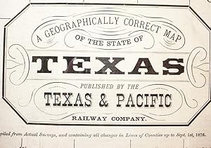
The / Texas / And / Pacific / Railway / The Shortest Line / To The Great / Cotton Grain And Stock / Regions / Of / Texas
Published by Woodward, Tiernan & Hale; St. Louis; pp.; Wraps; VG; nc/1878, 1878
Seller: Watermark West Rare Books, Wichita, KS, U.S.A.
Seller rating 4 out of 5 stars

Map
No Binding. Condition: Very Good. _____Large sheet, 20 x 21.25", folded to 18 panels._____ All the folds are tender, most have started at least at the edges._____ Some have archival reinforcements on the text side._____ There are two 1/2" holes, at interior corners of the folds._____ One is at (roughly) Del Rio, the other east of Seguin and SE of Lockhart. _____ The text side is occupied with four panels of time tables in effect from June 1, 1878._____ Five panels are devoted to the article "Texas / The / Garden State of America." Six more are given over to "Northern Texas! / Its Soil, climate, Products and Resources." The final panel is an "Extract / from the / Constitution of the State of Texas / Relating to the Homesteads of Families.". _____ The entire interior is "A Geographically Correct Map / of the State of / Texas / Published by the / Texas & Pacific / Railway Company."_____ Printed in shades of green, it depicts counties, creeks and landmarks throughout the state and most of the Indian Territory._____ The route of the T&P is shown throughout Texas, though the western 3/4 appears to be "Projected.". _____ The map side has a rubber stamp from the Arkansas & Texas Land & Passenger Agency in Cincinnati._____ There is a smaller stamp on the text side from an Ohio land agent. _____.