Mercator Gerard (741 results)

Published by Antwerpen, Stad 1994 1994
- Softcover
Seller: Antiquariaat Schot, Hendrik-Ido-Ambacht, NetherlandsAntiquariaat Schot
Contact seller5-star sellerCondition: Used
US$ 21.75
US$ 28.69 shippingShips from Netherlands to U.S.A.Quantity: 1 available
175 p. Paperback.
Published by Walker & Company, New York
- Hardcover
Seller: Burton Lysecki Books, ABAC/ILAB, Winnipeg, MB, CanadaBurton Lysecki Books, ABAC/ILAB
Contact seller5-star sellerCondition: Used
US$ 26.25
US$ 25.00 shippingShips from Canada to U.S.A.Quantity: 1 available
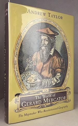
[0-8027-1377-7] 2004. (Hardcover) Near fine in fine dust jacket. 291pp. Illustrations, maps, notes, bibliography, index. "The story of discovery and mapmaking is one of pushing back shadows, and no one in the last two thousand years achieved as much as Gerard Mercator in extending the boundaries of the known world. His life span…ned most of the turbulent, extraordinary sixteenth century". Biography of Gerard Mercator. Time Period 16th Century. (Travel, Cartographers, Cartography, Geography, Mapmaking, Navigation, Travel).
Published by LondonPrinted by T.Cotes for Michael Sparkes and Samuel Cartwright . 1635
- Map
Seller: Robert Frew Ltd. ABA ILAB, London, , United KingdomRobert Frew Ltd. ABA ILAB
Contact seller5-star sellerCondition: Used
US$ 34.07
US$ 13.23 shippingShips from United Kingdom to U.S.A.Quantity: 1 available
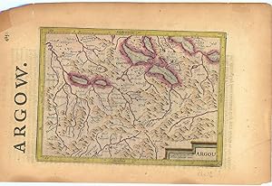
Original engraved map of Argau / Switzerland (map dimensions 19.2 x 14 cm, overall dimensions 29.5 x 18.5 cm) with later hand-colouring. Covering the area around the Lake Lucerne, Lake Zurich and Lake Thun. With English text to verso. A bit tanned and with a few small nicks to margins, generally very good. From "Historia Mundi o…r Mercator's Atlas .".
- Softcover
Seller: Antiquariaat A. Kok & Zn. B.V., Amsterdam, , NetherlandsAntiquariaat A. Kok & Zn. B.V.
Contact seller5-star sellerCondition: Used
US$ 19.51
US$ 32.44 shippingShips from Netherlands to U.S.A.Quantity: 1 available
Antwerpen, Stad Antwerpen, Museum Plantin-Moretus & Stedelijk Prentenkabinet, 1994. 175 pp. Col. & b./w. ills. Softcover. (Publicaties van het Museum Plantin-Moretus en het Stedelijk Prentenkabinet, nr. 29).Text in Dutch & French. - Exhibition catalogue.
- Hardcover
Seller: Antiquariaat A. Kok & Zn. B.V., Amsterdam, , NetherlandsAntiquariaat A. Kok & Zn. B.V.
Contact seller5-star sellerCondition: Used
US$ 19.51
US$ 32.44 shippingShips from Netherlands to U.S.A.Quantity: 1 available
Amst., 2003. 364,[1] pp. Col. & b./w. ills. Orig. hardcover, d./j.
Language: Latin
Published by Amsterdam, Janssonius 1628
- Art Print
Seller: Antiquariat Steffen Völkel GmbH, Seubersdorf, GermanyAntiquariat Steffen Völkel GmbH
Contact seller5-star sellerCondition: Used
US$ 11.81
US$ 34.43 shippingShips from Germany to U.S.A.Quantity: 1 available
Original Kupferstich-Karte von 1628 aus "Atlas Minor" von Gerard Mercator - aus der Lateinischen Ausgabe - Blatt-Maße: ca. 23,5 x 18 cm - teils leicht fleckig - sonst gut erhalten. -- Original engraving map of 1628 from "Atlas Minor" by Gerard Mercator's - from the Latin edition - slightly stained - otherwise in good condition.…| Dies ist ein Original! - Kein Nachdruck! - Keine Kopie! -- This is an original! - No copy! - No reprint! // Wir, das Antiquariat Steffen Völkel, kaufen und verkaufen alte Bücher, Handschriften, Zeichnungen, Autographen, Grafiken und Fotografien. Wir sind stets am Ankauf von kompletten Bibliotheken, Sammlungen und Nachlässen interessiert. la Gewicht in Gramm: 10.
- Softcover
Seller: Mooney's bookstore, Den Helder, NetherlandsMooney's bookstore
Contact seller4-star sellerCondition: Used - Very good
US$ 133.82
US$ 17.16 shippingShips from Netherlands to U.S.A.Quantity: 1 available
Condition: Very good.
- Softcover
Seller: Antiquariaat A. Kok & Zn. B.V., Amsterdam, , NetherlandsAntiquariaat A. Kok & Zn. B.V.
Contact seller5-star sellerCondition: Used
US$ 25.35
US$ 32.44 shippingShips from Netherlands to U.S.A.Quantity: 1 available
Bruxelles, Cre dit Communal, 1994. 157 pp. Col. & b./w. ills. Softcover. - Stamp on half-title.Contribution in French by various authors.
Language: Latin
Published by Amsterdam, Janssonius 1651
- Art Print
Seller: Antiquariat Steffen Völkel GmbH, Seubersdorf, GermanyAntiquariat Steffen Völkel GmbH
Contact seller5-star sellerCondition: Used
US$ 17.72
US$ 34.43 shippingShips from Germany to U.S.A.Quantity: 1 available
Blatt-Maße: ca. 17,5 x 23 cm -- Original Kupferstich-Karte von Gerard Mercator. Rückseitig mit deutschem Text. Aus der deutschen Ausgabe des "Atlas Minor" von 1651. - gut erhalten. || Rare original copper engraved map by Gerard Mercator. With German text on verso. From the German edition of the "Atas Minor" from the year 1651. -…- in very good condition. || The Flemish engraver and cartographer Jodocus Hondius (15631612), bought Mercator's plates after his death, and published this reduced version of Mercator's folio Atlas sive Cosmographis, and added some 36 of his own maps - a pocketversion - Atlas Minor - which Hondius published together with his partners Cornelius Claesz and Johannes Janssonius. It became a large success, and was translated into several languages and issued in c. 40 editions. // Wir, das Antiquariat Steffen Völkel, kaufen und verkaufen alte Bücher, Handschriften, Zeichnungen, Autographen, Grafiken und Fotografien. Wir sind stets am Ankauf von kompletten Bibliotheken, Sammlungen und Nachlässen interessiert. la Gewicht in Gramm: 10.
Language: Latin
Published by Amsterdam, Janssonius 1628
- Art Print
Seller: Antiquariat Steffen Völkel GmbH, Seubersdorf, GermanyAntiquariat Steffen Völkel GmbH
Contact seller5-star sellerCondition: Used
US$ 17.72
US$ 34.43 shippingShips from Germany to U.S.A.Quantity: 1 available
Original Kupferstich-Karte von 1628 aus "Atlas Minor" von Gerard Mercator - aus der Lateinischen Ausgabe - Blatt-Maße: ca. 23,5 x 18 cm - gut erhalten. -- Original engraving map of 1628 from "Atlas Minor" by Gerard Mercator's - from the Latin edition - good condition. | Dies ist ein Original! - Kein Nachdruck! - Keine Kopie! --…This is an original! - No copy! - No reprint! // Wir, das Antiquariat Steffen Völkel, kaufen und verkaufen alte Bücher, Handschriften, Zeichnungen, Autographen, Grafiken und Fotografien. Wir sind stets am Ankauf von kompletten Bibliotheken, Sammlungen und Nachlässen interessiert. la Gewicht in Gramm: 10.
- Softcover
Seller: Antiquariaat A. Kok & Zn. B.V., Amsterdam, , NetherlandsAntiquariaat A. Kok & Zn. B.V.
Contact seller5-star sellerCondition: Used
US$ 29.25
US$ 32.44 shippingShips from Netherlands to U.S.A.Quantity: 1 available
Duisburg, Walter Braun Verlag, 1996. X,274 pp. B./w. ills. Softcover. 8vo. (Duisburger Forschungen, Band 42. / Kartographiehistorisches Colloquium, 7).Contains contributions by cartography historians from various countries covering topics from the history of cartography from the Renaissance. - Text in German.
Published by AmsterdamJansson. 1634
- Map
Seller: Robert Frew Ltd. ABA ILAB, London, , United KingdomRobert Frew Ltd. ABA ILAB
Contact seller5-star sellerCondition: Used
US$ 54.51
US$ 13.23 shippingShips from United Kingdom to U.S.A.Quantity: 1 available
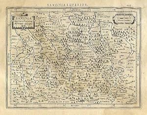
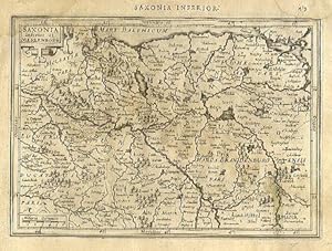
13.6 x 18.2 cm. Uncoloured. Single page map of Saxony and the surrounding regions. Latin text on verso. Dampstain across upper and right edges of sheet, browned overall.
Published by AmsterdamJansson. 1634
- Map
Seller: Robert Frew Ltd. ABA ILAB, London, , United KingdomRobert Frew Ltd. ABA ILAB
Contact seller5-star sellerCondition: Used
US$ 54.51
US$ 13.23 shippingShips from United Kingdom to U.S.A.Quantity: 1 available
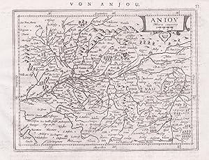
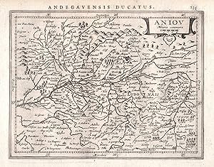
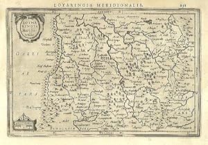
13.4 x 19.9 cm. Uncoloured. Single page map of southern Lorraine. Latin text on verso. Light dampstain at upper left corner, otherwise in good condition.
Published by AmsterdamJansson. 1634
- Map
Seller: Robert Frew Ltd. ABA ILAB, London, , United KingdomRobert Frew Ltd. ABA ILAB
Contact seller5-star sellerCondition: Used
US$ 54.51
US$ 13.23 shippingShips from United Kingdom to U.S.A.Quantity: 1 available
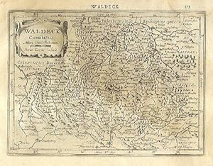
14.2 x 19.3 cm. Uncoloured. Single page map of the region surrounding Waldeck, northern Hessen. Latin text on verso. Light dampstain across upper and right edges of sheet.
Published by AmsterdamJansson. 1634
- Map
Seller: Robert Frew Ltd. ABA ILAB, London, , United KingdomRobert Frew Ltd. ABA ILAB
Contact seller5-star sellerCondition: Used
US$ 54.51
US$ 13.23 shippingShips from United Kingdom to U.S.A.Quantity: 1 available
14.2 x 20 cm. Uncoloured. Single page map showing what are now the regions of Schwerin, Rostock and Neubrandenburg. Latin text on verso. Dampstain across upper and right edges of sheet, browned overall.
Published by AmsterdamJansson. 1634
- Map
Seller: Robert Frew Ltd. ABA ILAB, London, , United KingdomRobert Frew Ltd. ABA ILAB
Contact seller5-star sellerCondition: Used
US$ 54.51
US$ 13.23 shippingShips from United Kingdom to U.S.A.Quantity: 1 available
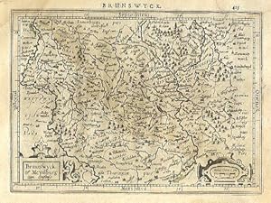
14.1 x 19.3 cm. Uncoloured. Single page map of the regions of Braunschweig and Magdeburg. Latin text on verso. Dampstain across upper and right edges of sheet, browned overall.
Published by AmsterdamJansson. 1634
- Map
Seller: Robert Frew Ltd. ABA ILAB, London, , United KingdomRobert Frew Ltd. ABA ILAB
Contact seller5-star sellerCondition: Used
US$ 54.51
US$ 13.23 shippingShips from United Kingdom to U.S.A.Quantity: 1 available
13.8 x 18.3 cm. Uncoloured. Single page map. Latin text on verso. Dampstain across upper and right edges of sheet, browned overall.
Published by AmsterdamJansson. 1634
- Map
Seller: Robert Frew Ltd. ABA ILAB, London, , United KingdomRobert Frew Ltd. ABA ILAB
Contact seller5-star sellerCondition: Used
US$ 54.51
US$ 13.23 shippingShips from United Kingdom to U.S.A.Quantity: 1 available
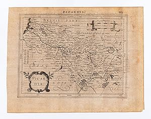
14.5 x 18.7 cm. Uncoloured. Single page map of Picardy. Latin text on verso. Impression weaker at upper right corner. Some light soiling at margins, otherwise in good condition.
Published by AmsterdamJansson. 1634
- Map
Seller: Robert Frew Ltd. ABA ILAB, London, , United KingdomRobert Frew Ltd. ABA ILAB
Contact seller5-star sellerCondition: Used
US$ 54.51
US$ 13.23 shippingShips from United Kingdom to U.S.A.Quantity: 1 available
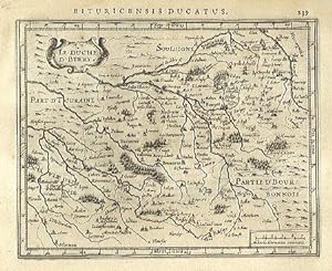
14.4 x 18.1 cm. Uncoloured. Single page map. Latin text on verso. Very good condition.
Published by AmsterdamJansson. 1634
- Map
Seller: Robert Frew Ltd. ABA ILAB, London, , United KingdomRobert Frew Ltd. ABA ILAB
Contact seller5-star sellerCondition: Used
US$ 54.51
US$ 13.23 shippingShips from United Kingdom to U.S.A.Quantity: 1 available
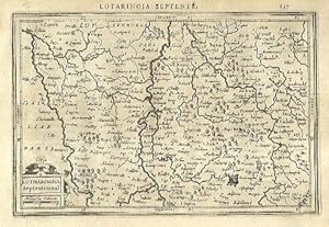
13.4 x 20.2 cm. Uncoloured. Single page map of northern Lorraine. Latin text on verso. Very good condition.
Published by AmsterdamJansson. 1634
- Map
Seller: Robert Frew Ltd. ABA ILAB, London, , United KingdomRobert Frew Ltd. ABA ILAB
Contact seller5-star sellerCondition: Used
US$ 54.51
US$ 13.23 shippingShips from United Kingdom to U.S.A.Quantity: 1 available
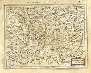
13.7 x 17.7 cm. Uncoloured. Single page map of Westfalen and the Nord Rhein. Latin text on verso. Dampstaining across upper and right edges of sheet.
Published by AmsterdamJansson. 1634
- Map
Seller: Robert Frew Ltd. ABA ILAB, London, , United KingdomRobert Frew Ltd. ABA ILAB
Contact seller5-star sellerCondition: Used
US$ 54.51
US$ 13.23 shippingShips from United Kingdom to U.S.A.Quantity: 1 available
14 x 19.1 cm. Uncoloured. Single page map of southern Alsace. Latin text on verso. Dampstain across upper and right edges of sheet, browned overall.

Published by AmsterdamJansson. 1634
- Map
Seller: Robert Frew Ltd. ABA ILAB, London, , United KingdomRobert Frew Ltd. ABA ILAB
Contact seller5-star sellerCondition: Used
US$ 54.51
US$ 13.23 shippingShips from United Kingdom to U.S.A.Quantity: 1 available
14.6 x 18 cm. Uncoloured. Single page map of the region surrounding Boulogne. Latin text on verso. Small red mark to centre right of image. Some show through text, otherwise in good condition.
 More images
Published by Amsterdam: Mercator/Hondius, 1609. 1609
Seller: William Matthews/The Haunted Bookshop, Sidney, BC, CanadaWilliam Matthews/The Haunted Bookshop
Contact seller5-star sellerCondition: Used
US$ 54.53
US$ 18.00 shippingShips from Canada to U.S.A.Quantity: 1 available
A copper engraved map on laid paper, uncoloured, from the 1609 German edition of the Mercator/Hondius ATLAS MINOR. Image size is 19cm x 13cm, on a sheet measuring 23cm x 18cm (9 x 7 inches). Cartouche at lower left. Text on map is in Latin. Text on verso is German. Page number on verso is 464. Clean, very good condition. A map o…f Österreich/Austria.
 More images
Published by Amsterdam: Mercator/Hondius, 1609. 1609
Seller: William Matthews/The Haunted Bookshop, Sidney, BC, CanadaWilliam Matthews/The Haunted Bookshop
Contact seller5-star sellerCondition: Used
US$ 54.53
US$ 18.00 shippingShips from Canada to U.S.A.Quantity: 1 available
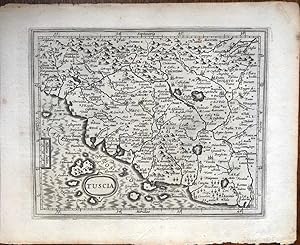
A copper engraved map on laid paper, uncoloured, from the 1609 German edition of the Mercator/Hondius ATLAS MINOR. Image size is 18cm x 14.5cm, on a sheet measuring 23.5cm x 18.5cm (9 x 7 inches). Small oval title cartouche at lower left. Text on map in Latin. Text on verso is German. Page number on verso is 524. Clean, very goo…d condition. A regional map of Italy, Tuscany and nearby.
 More images
Published by Amsterdam: Mercator/Hondius, 1609. 1609
Seller: William Matthews/The Haunted Bookshop, Sidney, BC, CanadaWilliam Matthews/The Haunted Bookshop
Contact seller5-star sellerCondition: Used
US$ 54.53
US$ 18.00 shippingShips from Canada to U.S.A.Quantity: 1 available
A copper engraved map on laid paper, uncoloured, from the 1609 German edition of the Mercator/Hondius ATLAS MINOR. Image size is 19.5cm x 15cm, on a sheet measuring 23.5cm x 18.5cm (9 x 7 inches). Cartouche at lower left. Text on map in Latin. Text on verso is German. Page number on verso is 320. Clean, very good condition. A re…gional map of Holland, Southern Netherlands.
 More images
Published by Amsterdam: Mercator/Hondius, 1609. 1609
Seller: William Matthews/The Haunted Bookshop, Sidney, BC, CanadaWilliam Matthews/The Haunted Bookshop
Contact seller5-star sellerCondition: Used
US$ 54.53
US$ 18.00 shippingShips from Canada to U.S.A.Quantity: 1 available
A copper engraved map on laid paper, uncoloured, from the 1609 German edition of the Mercator/Hondius ATLAS MINOR. Image size is 20cm x 13.5cm, on a sheet measuring 23.5cm x 18.5cm. Cartouche in lower left. Text on map in Latin. Text on verso is German, heading "Von dem Theyl gegen Mittag .". Page number on verso is 262. Crease…& stain to lower left margin, very good condition. A regional map of Lorraine, Luxembourg and Northern France.
 More images
Published by Amsterdam: Mercator/Hondius, 1609. 1609
Seller: William Matthews/The Haunted Bookshop, Sidney, BC, CanadaWilliam Matthews/The Haunted Bookshop
Contact seller5-star sellerCondition: Used
US$ 54.53
US$ 18.00 shippingShips from Canada to U.S.A.Quantity: 1 available
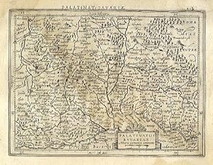
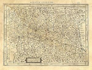
A copper engraved map on laid paper, uncoloured, from the 1609 German edition of the Mercator/Hondius ATLAS MINOR. Image size is 18cm x 13.5cm, on a sheet measuring 23cm x 18cm (9 x 7 inches). Cartouche at upper right. Text on map is in Latin. Text on verso is German. Page number on verso is 442. Clean, short tear in lower margi…n, very good condition. A regional map of Germany, Bavaria.
 More images
Published by Amsterdam: Mercator/Hondius, 1609. 1609
Seller: William Matthews/The Haunted Bookshop, Sidney, BC, CanadaWilliam Matthews/The Haunted Bookshop
Contact seller5-star sellerCondition: Used
US$ 54.53
US$ 18.00 shippingShips from Canada to U.S.A.Quantity: 1 available
A copper engraved map on laid paper, uncoloured, from the 1609 German edition of the Mercator/Hondius ATLAS MINOR. Image size is 19cm x 14.5cm, on a sheet measuring 23cm x 18cm (9 x 7 inches). Cartouche at upper right. Text on map is in Latin. Text on verso is German. Page number on verso is 408. Clean, very good condition. A re…gional map of Germany.
 More images
Published by Amsterdam: Mercator/Hondius, 1609. 1609
Seller: William Matthews/The Haunted Bookshop, Sidney, BC, CanadaWilliam Matthews/The Haunted Bookshop
Contact seller5-star sellerCondition: Used
US$ 54.53
US$ 18.00 shippingShips from Canada to U.S.A.Quantity: 1 available
A copper engraved map on laid paper, uncoloured, from the 1609 German edition of the Mercator/Hondius ATLAS MINOR. Image size is 18cm x 14.5cm, on a sheet measuring 23cm x 18cm (9 x 7 inches). Cartouche at lower right. Text on map is in Latin. Text on verso is German. Page number on verso is 536. Clean, very good condition. A re…gional map of Italy.


