Otzakoff (1 results)
 More images
Published by NP: c.1737., 1737
Seller: William Matthews/The Haunted Bookshop, Sidney, BC, CanadaWilliam Matthews/The Haunted Bookshop
Contact seller5-star sellerCondition: Used
US$ 1,449.82
US$ 18.00 shippingShips from Canada to U.S.A.Quantity: 1 available
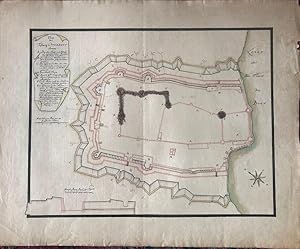
A group of four manuscript maps on laid paper, expertly executed in ink & watercolour. The maps bear captions and text in German; two bear the legend: "Project der Linie welche unversaumt vor der Stadt Otzakoff in der weite eines Canonenschusses gemacht werden soll worhinter beij Somers Zeit die Regimenter Campiren könen". They…are basically two versions each of two different maps, one a larger overview and one a close-in view. They are variously captioned and bear different cartouches with Explications and text in German. Two versions of the overview map have similar, but not identical Explications, within different cartouches at different locations on the sheet; they also differ in several respects from a copy held in the Military Archives of Sweden. This overview map is notably similar in layout to that produced by Matthaus Seutter in c.1737. The close-in map is titled: Plan der Vestung Otzakoff (One uses "Testung" in the title). This map likewise has different cartouches, and slightly different text within them. The smaller of the two here has not had the capital letters added within the map to relate it to the Key in the cartouche, and is evidently an earlier version. Though oriented differently, these are very similar to the map "Plan der Vestung Otzakoff" from the military map collection of George III [attributed to O.C. de Marin] although George III's map has a more complex lettering/key system. It also closely resembles the map of Otzakoff in Frederik den Femtes Atlas (Volume 44, Plate 54). These four maps all have some short tears in margins, a few small stains, but are in general clean and in very good condition. The larger close-in map has some old stains to the upper right section. The smaller two have been mounted (sticky tape, upper margins, on verso) on larger sheets. The two smaller maps have image sizes of 51cm x 39cm (overview map) and 53cm x 41cm (close-in map); the larger maps have image sizes of 57cm x 35cm (overview map) and 51cm x 39cm (close-in map). The German text on the overview maps relates to the distance from Otzakoff where a regiment can camp, out of range of cannon-shot; the text on the close-in maps relates to the 1737 Russian siege of Otzakoff. Undated, but mid-18th century. For the four maps.
