Order Total (1 Item Items):
Shipping Destination:

Philipp Cluverius (43 results)
Skip to main search results
Search filters
Product Type
- All Product Types
- Books (9)
- Magazines & Periodicals (No further results match this refinement)
- Comics (No further results match this refinement)
- Sheet Music (No further results match this refinement)
- Art, Prints & Posters (No further results match this refinement)
- Photographs (No further results match this refinement)
- Maps (34)
- Manuscripts & Paper Collectibles (No further results match this refinement)
Condition Learn more
- New (No further results match this refinement)
- As New, Fine or Near Fine (2)
- Very Good or Good (4)
- Fair or Poor (1)
- As Described (36)
Binding
- All Bindings
- Hardcover (3)
- Softcover (No further results match this refinement)
Collectible Attributes
- First Edition (1)
- Signed (No further results match this refinement)
- Dust Jacket (No further results match this refinement)
- Seller-Supplied Images (26)
- Not Print on Demand (43)
Language (3)
Free Shipping
- Free Shipping to U.S.A. (No further results match this refinement)
Seller Location
Seller Rating
-

Africa Minor - Cyrenaica - Mauritania. Karte aus: Introductio in Universam Geographiam
Published by o.J. um 1660, 1660
Map
Condition: Befriedigend. Karte aus Cl�vers Werk 'Introductio in Universam Geographiam' ohne Jahr, um 1660. Dreigeteilte Darstellung mit der Tunesischen K�ste, der Cyrenaica und der Hauptkarte Mauretanien. Die Karte ist mittig gefaltet, am linken Rand mit Knickspuren und einem starken Fl�ssigkeitsfleck am oberen Eck rechts. Sprache / Language: la 1 Seiten. ca. 17,1 x 20,6 cm.
-
Philippi Cluverii Introductio in universam geographiam tam veterem quam novam. Tabulis geographicis XLVI ac notis olim ornata a Johanne Bunone, jam vero locupletata additamentis & annotationibus Joh. Frid. Hekelii & Joh. Reiskii. Cum privilegio ordinum Ho
Language: French
Published by Jean Wolters, Amsterdam, 1697
Seller: Des livres autour (Julien Mannoni), Paris, PARIS, France
Seller rating 4 out of 5 stars

First Edition
Plein V�lin. Condition: Bon. First Thus. Amsterdam [Amstelaedami], Jean Wolters [Joannem Wolters], 1697. 24 x 18 cm (R), in-4, 1 f. bl. - titre frontispice enti�rement grav� - 11 ff. n. ch. (dont titre, d�dicace, adresse au lecteur, epistolae, table et privil�ge) - 565 pp. - 31 ff. n. ch. d'index - 2 ff. bl. - 2 planches, 3 tableaux et 41 (sur 43) cartes grav�es hors texte, dont 40 sont d�pliantes ou � double page, reliure hollandaise de l'�poque en plein v�lin dor�, plats estamp�s � froid de motifs des Pays Bas espagnols dans un double encadrement de filets avec fleurons d'angle, dos estamp� de filets et fleurons, titre manuscrit � l'�poque, traces de lacets. (sig. *3, **4, ***4, A-Z4, Aa-Zz4, Aaa-Zzz4, Aaaa-Kkkk4) Belle �dition de la fin du XVIIeme du c�l�bre atlas de Cl�ver, avec les commentaires de Buno, Reiske et Heckel, int�ressante notamment parce qu'elle est au format in-4 et non in-8 ou in-12, comme la plupart des autres. Un bel ex-dono, dat� de 1725 et couvrant tout le premier feuillet blanc, nous indique qu'il s'agit d'un livre de prix. Cachets annul�s d'une biblioth�que de capucins au titre. Sans la mappemonde et la carte l'Am�rique. Exemplaire tr�s l�g�rement d�r�gl�, ce qui est courant pour un volume de cette taille, une carte d�tach�e, pour le reste un fort bel exemplaire exempt de rousseurs et dans une belle reliure estamp�e de l'�poque. dv.
-
Italia antiqua auctoris methodo, verbis et tabulis geographicis retentis (Philippi Cluverii)
Published by Guelferbyti: Buno; Wolfenbuttel, 1659
Seller: Sequitur Books, Boonsboro, MD, U.S.A.
Association Member: IOBA
Seller rating 5 out of 5 stars

Hardcover. Condition: Fair. 4to. 21 cm. Bound in contemporary calf. Spine ends chipped, front joint cracked. Solid binding. Wear to extremities. Substantial browning/toning to text. [12], 773 [i. e., 768], [44] pp. Engraved title. 4 folding engraved maps of Italy; folding bird's-eye view of Rome, at rear. Maps in good shape.
-
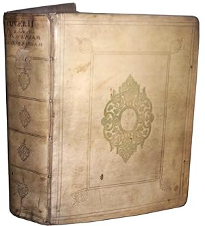
Philippi Cluverii Introductionis in Universam Geographiam tam Veterem quam Novam Libri VI. Tabulis aeneis illustrati. Accessit P. Bertii Breviarium Orbis Terrarum
Published by Amstelodami [Amsterdam]: Ex Officina Elzeviriana [Daniel Elzevir] 1661, 1661
Seller: Antikvariat Valentinska, Praha, Czech Republic
Association Member: ILAB
Seller rating 5 out of 5 stars
US$ 1,054.92
US$ 30.16 shipping
Ships from Czech Republic to U.S.A.Quantity: 1 available
Add to basketOne of the later editions of the "Introduction to Universal Geography", the first comprehensive modern geography, originally published in 1624-1629; it remained a standard work through the mid-18th century; the first of its six parts deals in general with the Earth, the remaining five contain short descriptions of countries and stress human and historical considerations. Written by Philipp Cl�ver (1580-1622), a Leiden-based German geographer, the founder of historical geography. This edition is supplemented with "Breviarium Totius Orbis Terrarum" and a survey of Roman emperors (short works by Petrus Bertius), followed by an index. The book features an engraved title page with putti and three figures of geographers. The copy contains a set of 4 fold-out plates (tables, diagrams) and 37 fold-out maps (copper engravings), both historical and modern, e.g. hemispheres, Europe, historical Roman provinces, Britain and Ireland, various European countries, various parts of Italy, Russia, Asia, China, India, Persia, Africa, America, various parts of the Middle East etc. Only a map of Galia is missing (torn away). Antiqua typeface; pages are decorated with headpieces and initials. The front endpaper and title leaf contain several ownership notes. /// Parchment binding (with handwritten title); hardback, [12]+388+[6]+[70] pp., 4 plates + 37 maps, 12� (7.5 x 13.5 cm), parchment discoloured and slightly worn, top edge darkened, fore edge with small ink stain, back hinge split, front free endpaper partly glued to front board, first plate with loss along bottom edge (diagram and text slightly corrupted), most pages, plates and maps with small narrow water stain along top edge, several maps with tear on folds, one map backed with small pieces of paper, one leaf's corner torn away (text slightly corrupted), last leaf partly detached, several leaves slightly worn along edges, other signs of wear and age are rare (minor creases and tears, small ink stain), one map missing, condition: good Book Language/s: Latin.
-

Veteris et Nov� Britanni� Descriptio.
Published by [London, c.1710-]. 210 x 255mm (8� x 10 inches)., 1710
Seller: Tooley, Adams & Co., Wallingford, OXON, United Kingdom
Seller rating 3 out of 5 stars

US$ 190.34
US$ 49.04 shipping
Ships from United Kingdom to U.S.A.Quantity: 1 available
Add to basketUncoloured; very light water staining to the right margin and the printed line border on the left, signs of old vertical folds from the book, otherwise very good condition. A map of the British Isles and Ireland in ancient times. Highly decorative, with inset map of the Orkney Islands. Originally published by Philipp Cl�ver (1580-1622) in "Introductio in universam geographiam" in 1624 (posthumously). There seems to have been several editions and this example bears the name of John Senex (fl 1702-1740) as engraver.
-

Helvetia conterminarumq. terrarum antiqua descriptio
Published by Braunschweig, 1678
Seller: Libreria Ex Libris ALAI-ILAB/LILA member, Roma, RM, Italy
Seller rating 5 out of 5 stars
Map
Incisione originale su rame (cm. 25,5x20,5 pi� ampi margini bianchi). Ottimo esemplare.
-
Chersonesi quae hodie Natolia descriptio
Published by Braunschweig, 1678
Seller: Libreria Ex Libris ALAI-ILAB/LILA member, Roma, RM, Italy
Seller rating 5 out of 5 stars
Map
Incisione originale su rame (cm. 25,5x21 pi� ampi margini bianchi). Ottimo esemplare.
-
Daciarum, Moesiarum et Thraciae vetus et nova descriptio
Published by Braunschweig, 1678
Seller: Libreria Ex Libris ALAI-ILAB/LILA member, Roma, RM, Italy
Seller rating 5 out of 5 stars
Map
Incisione originale su rame (cm. 25x21 pi� ampi margini bianchi). Ottimo esemplare.
-
Hodiernae Belgicae sive Germaniae Inferioris tabula
Published by Braunschweig, 1678
Seller: Libreria Ex Libris ALAI-ILAB/LILA member, Roma, RM, Italy
Seller rating 5 out of 5 stars
Map
Incisione originale su rame (cm. 25,5x21 pi� ampi margini bianchi). Ottimo esemplare.
-
Sarmatia et Scythia, Russia et Tartaria Europaea
Published by Braunschweig, 1678
Seller: Libreria Ex Libris ALAI-ILAB/LILA member, Roma, RM, Italy
Seller rating 5 out of 5 stars
Map
Incisione originale su rame (cm. 25,5x24 pi� ampi margini bianchi). Ottimo esemplare.
-
Scythia et Tartaria Asiatica
Published by Braunschweig, 1678
Seller: Libreria Ex Libris ALAI-ILAB/LILA member, Roma, RM, Italy
Seller rating 5 out of 5 stars
Map
Incisione originale su rame (cm. 25,5x21 pi� ampi margini bianchi). Ottimo esemplare.
-
Vindeliciae et Norici, conterminarumq. terrarum antiqua descriptio
Published by Braunschweig, 1678
Seller: Libreria Ex Libris ALAI-ILAB/LILA member, Roma, RM, Italy
Seller rating 5 out of 5 stars
Map
Incisione originale su rame (cm. 25,5x20,5 pi� ampi margini bianchi). Ottimo esemplare.
-
Syriae sive Soriae descriptio
Published by Braunschweig, 1678
Seller: Libreria Ex Libris ALAI-ILAB/LILA member, Roma, RM, Italy
Seller rating 5 out of 5 stars
Map
Incisione originale su rame (cm. 25x20,5 pi� ampi margini bianchi). Ottimo esemplare.
-
Veteris et nova Pannoniae et Illyrici descriptio
Published by Braunschweig, 1678
Seller: Libreria Ex Libris ALAI-ILAB/LILA member, Roma, RM, Italy
Seller rating 5 out of 5 stars
Map
Incisione originale su rame (cm. 24,5x21 pi� ampi margini bianchi). Ottimo esemplare.
-
Germaniae Cisrhenanae ut inter I. Caesaris et Traiani fuit Imperia Scaldis item Mosae hac Rheni ostiorum antiqua descriptio
Published by Braunschweig, 1678
Seller: Libreria Ex Libris ALAI-ILAB/LILA member, Roma, RM, Italy
Seller rating 5 out of 5 stars
Map
Incisione originale su rame (cm. 25,5x25 pi� ampi margini bianchi). Ottimo esemplare.
-
Africa antiqua et nova
Published by Braunschweig, 1678
Seller: Libreria Ex Libris ALAI-ILAB/LILA member, Roma, RM, Italy
Seller rating 5 out of 5 stars
Map
Incisione originale su rame (cm. 26x22 pi� ampi margini bianchi). Ottimo esemplare.
-
Indiae Orientalis et Insularum adiacentium antiqua et nova descriptio
Published by Braunschweig, 1678
Seller: Libreria Ex Libris ALAI-ILAB/LILA member, Roma, RM, Italy
Seller rating 5 out of 5 stars
Map
Incisione originale su rame (cm. 26,5x22 pi� ampi margini bianchi). Ottimo esemplare.
-
Nova totius Germaniae descriptio
Published by Braunschweig, 1678
Seller: Libreria Ex Libris ALAI-ILAB/LILA member, Roma, RM, Italy
Seller rating 5 out of 5 stars
Map
Incisione originale su rame (cm. 33x26,5 pi� ampi margini bianchi). Ottimo esemplare.
-
Svecia, Dania et Norvegia
Published by Braunschweig, 1678
Seller: Libreria Ex Libris ALAI-ILAB/LILA member, Roma, RM, Italy
Seller rating 5 out of 5 stars
Map
Incisione originale su rame (cm. 26,5x21,5 pi� ampi margini bianchi). Ottimo esemplare.
-
Veteris et novae Britanniae descriptio
Published by Braunschweig, 1678
Seller: Libreria Ex Libris ALAI-ILAB/LILA member, Roma, RM, Italy
Seller rating 5 out of 5 stars
Map
Incisione originale su rame (cm. 26x21,5 pi� ampi margini bianchi). Ottimo esemplare.
-
Persia sive Sophorum Regnum cum Armenia, Assyria, Mesopotamia et Babilonia
Published by Braunschweig, 1678
Seller: Libreria Ex Libris ALAI-ILAB/LILA member, Roma, RM, Italy
Seller rating 5 out of 5 stars
Map
Incisione originale su rame (cm. 26x21 pi� ampi margini bianchi). Ottimo esemplare.
-
Gallia antiqua et nova
Published by Braunschweig, 1678
Seller: Libreria Ex Libris ALAI-ILAB/LILA member, Roma, RM, Italy
Seller rating 5 out of 5 stars
Map
Incisione originale su rame (cm. 32,5x27 pi� ampi margini bianchi). Ottimo esemplare.
-

Summa Europae antiquae descriptio
Published by Braunschweig, 1678
Seller: Libreria Ex Libris ALAI-ILAB/LILA member, Roma, RM, Italy
Seller rating 5 out of 5 stars
Map
Incisione originale su rame (cm. 25,5x21 pi� ampi margini bianchi). Ottimo esemplare.
-

Apuliae; Mesapiae, in qua Calabri ac Salentini, et Lucaniae descriptio
Published by Leida, 1624
Seller: Libreria Ex Libris ALAI-ILAB/LILA member, Roma, RM, Italy
Seller rating 5 out of 5 stars
Map
Carta geografica originale (cm. 36,5x27 pi� ampi margini bianchi) tratta dall'opera 'Italia antiqua'. Impressa su carta vergellata con filigrana. Bella coloritura antica all'acquarello. Esemplare in ottimo stato di conservazione. Non comune.
-

Latii utriusque, antiqui scilicet; et novi in quo Aequi, Rutuli, Volsci, Hernici et Auruci, descriptio.
Published by Leida, 1624
Seller: Libreria Ex Libris ALAI-ILAB/LILA member, Roma, RM, Italy
Seller rating 5 out of 5 stars
Map
Carta geografica originale (cm. 36,5x28,5 pi� ampi margini bianchi) tratta dall'opera 'Italia antiqua'. Impressa su carta vergellata con filigrana. Bella coloritura antica all'acquarello. Esemplare in ottimo stato di conservazione. Non comune.
-

Samni et Campaniae item Hirpinorum et Picentinorum Agri descriptio
Published by Leida, 1624
Seller: Libreria Ex Libris ALAI-ILAB/LILA member, Roma, RM, Italy
Seller rating 5 out of 5 stars
Map
Carta geografica originale (cm. 36,5x28,5 pi� ampi margini bianchi) tratta dall'opera 'Italia antiqua'. Impressa su carta vergellata con filigrana. Bella coloritura antica all'acquarello. Esemplare in ottimo stato di conservazione. Non comune.
-

Italia antiqua
Published by Braunschweig, 1678
Seller: Libreria Ex Libris ALAI-ILAB/LILA member, Roma, RM, Italy
Seller rating 5 out of 5 stars
Map
Carta geografica originale (cm. 32,5x27 pi� ampi margini bianchi). Ottimo esemplare.
-

Hispaniae veteris et novae descriptio
Published by Braunschweig, 1678
Seller: Libreria Ex Libris ALAI-ILAB/LILA member, Roma, RM, Italy
Seller rating 5 out of 5 stars
Map
Incisione originale su rame (cm. 32,5x27 pi� ampi margini bianchi). Ottimo esemplare.
-

Corsicae antiquae descriptio. Sardiniae antiquae descriptio
Published by Braunschweig, 1678
Seller: Libreria Ex Libris ALAI-ILAB/LILA member, Roma, RM, Italy
Seller rating 5 out of 5 stars
Map
Incisione originale su rame (cm. 11,5x27 pi� ampi margini bianchi). Ottimo esemplare.
-

Asia antiqua et nova
Published by Braunschweig, 1678
Seller: Libreria Ex Libris ALAI-ILAB/LILA member, Roma, RM, Italy
Seller rating 5 out of 5 stars
Map
Incisione originale su rame (cm. 26,5x21 pi� ampi margini bianchi). Ottimo esemplare.