Ptolemaeus: Signed (7 results)
 More images
Published by Lienhart Holle, Ulm, Germany 1482
- Signed
- Map
Seller: Donald A. Heald Rare Books (ABAA), New York, NY, U.S.A.Donald A. Heald Rare Books (ABAA)
Contact seller5-star sellerCondition: Used
US$ 18,500.00
US$ 25.00 shippingShips within U.S.A.Quantity: 1 available
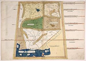
Map. Double-page woodcut map with fine original hand-coloring and Latin place-names in letterpress type. Carved gold leaf frame with Amiran anti-reflective archival glass with UV protection. Scale: c.1:4,000,000. Sheet: (15 1/2 x 22 3/8 inches). Frame: (25 1/2 x 32 1/4 inches). One of the earliest obtainable maps of the Middle E…ast and the Kathiawar Peninsula of India, Mahatama Gandhi's birthplace. This hand-colored incunable map is from the 1482 Ulm edition of Ptolemy's "Geographia," the first atlas to be printed north of the Alps and the first with woodcut maps. Here with fine period coloring, including a lapis lazuli blue sea, not the ochre color of late editions. This rare incunable is one of the earliest obtainable maps to picture the Middle East and Central Asia regions. It is from the 1482 Ulm edition of Ptolemy's Geographia, printed by Lienhart Holle and titled Cosmographia, in which Donnus Nicolaus Germanus adapted Ptolemy's second century cartography and added five modern maps. This map shows the eastern extent of the lands Alexander the Great conquered; the place-names are classical. Political delineations are already indicated by color: in tan is Arachosia, present-day southern Afghanistan centered on Kandahar; Paropanisus is in yellow, which is now parts of Afghanistan and Pakistan; in green is Drangiana, which encompassed what is now the border between Iran and Afghanistan; Aria, present-day western Afghanistan, is also seen with a yellow wash; Gedrosia is today Iran; and in the lower right-hand corner is Kathiawar, the Indian peninsula that is the birthplace of Mahatma Gandhi. The Arabian Sea is called the Indian Sea (Mare Indicum) and is captured in luxurious lapis lazuli blue. The Hindu Kush and other mountain ranges in the region are depicted with tan amorphous shapes. The 1482 Ulm atlas was a revelation in its manifold innovations: it was the first printed north of the Alps; the first with woodcut maps; the first with maps "signed" by the artist responsible - its world map states "Engraved by Johann, woodcutter from Armszheim" - and his backward "N" was cut into each woodblock used to print the maps; it was the first Ptolemaic atlas with 32 maps; the first to come with publisher's coloring or directions for embellishment; and the first to print text on the verso discussing the map on each corresponding recto. [Shirley] The Cosmographia atlas was the first book printed by Lienhart Holle: a masterful debut. But with its 32 individual hand-colored woodcut maps, all printed with letterpress type, it was very expensive to produce and its publication bankrupted Holle. The remaining sheets, woodblocks, matrices, and type were taken up by another printer in Ulm, Johann Reger, who reissued the work in 1486. Those second edition Reger maps are seen with the less desirable ochre washes over the sea in place of lapis lazuli blue, as here. "Claudius Ptolemaeus is the Latinized name of the geographer and astronomer who is more generally known as Ptolemy and who lived in Alexandria, Egypt, from 90-168 AD. His principal geographic work, the Geographia was transmitted from classical times and was the first atlas to be printed. The text is based on the translation from the Greek by Jacobus Angelus." [Shirley] The five modern maps were based on manuscript projections by the editor of the work, Donnus Nicolaus Germanus, a Benedictine monk from the diocese of Breslau who lived and worked in Florence. Germanus likely invented the trapezoid projection, which became known as the Donis-projection; it allows one to represent a three dimensional, spherical section on a two dimensional page. Campbell concludes that the "major achievement of the Ptolemaic maps was to introduce a formalized grid of longitude and latitude, in conjunction with positions obtained through astronomical observations. By favoring the shortest of various Greek estimates as to the circumference of the earth and arriving at a much reduced value for a degree of longitud.
Published by Lienhart Holle, Ulm, Germany 1482
- Signed
- Map
Seller: Donald A. Heald Rare Books (ABAA), New York, NY, U.S.A.Donald A. Heald Rare Books (ABAA)
Contact seller5-star sellerCondition: Used
US$ 25,000.00
US$ 25.00 shippingShips within U.S.A.Quantity: 1 available
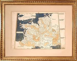
Map. Double-page woodcut map with fine original hand-coloring and Latin place names in letterpress. Carved gold leaf frame with Amiran anti-reflective archival glass with UV protection. Scale: c.1:4,000,000. Sheet: (15 1/2 x 22 1/4 inches). Frame: (25 1/2 x 32 1/4 inches). A beautiful incunable map of Western Europe from the 148…2 Ulm edition of Ptolemy's "Geographia." This map is from the first atlas to be printed north of the Alps and the first with woodcut maps. Here with fine period coloring, including lapis lazuli blue seas, not the ochre color of later editions. This rare incunable map is one of the earliest to picture modern France and Belgium. It is from the 1482 Ulm edition of Ptolemy's Geographia, printed by Lienhart Holle and titled Cosmographia, in which Donnus Nicolaus Germanus adapted Ptolemy's second century cartography and added five modern maps, including the present one. Seen here is the entirety of France (Frantia) and Belgium; parts of England (Anglie), Spain (Hispanie), Germany (Germanie), and Holland, as well as many of the French islands including Jersey. Indicated, too, is the Mediterranean Sea (Mare Mediterranevm) and Mare Gallicum (French Sea, today the Bay of Biscay), both captured in luxurious lapis lazuli blue. This map directly followed another map of France in the 1482 Ulm which focused on the political divisions and regions of the area, whereas this map includes more topographical features, with amorphous tan shapes indicating France's seven mountain ranges including the Alps and the Pyrenees. It is the more attractive of the two. The 1482 Ulm atlas was a revelation in its manifold innovations: it was the first printed north of the Alps; the first with woodcut maps; the first with maps "signed" by the artist responsible - its world map states "Engraved by Johann, woodcutter from Armszheim" - and his backward "N" was cut into each woodblock used to print the maps; it was the first Ptolemaic atlas with 32 maps; the first to come with publisher's coloring or directions for embellishment; and the first to print text on the verso discussing the map on each corresponding recto. [Shirley] The Cosmographia atlas was the first book printed by Lienhart Holle: a masterful debut. But with its 32 individual hand-colored woodcut maps, including a world map, all printed with letterpress type, it was disastrously expensive to produce and its publication bankrupted Holle. The remaining sheets, woodcuts, matrices, and type were taken up by another printer in Ulm, Johann Reger, who reissued the work in 1486. Those second edition Reger maps are seen with the less desirable ochre washes over the sea in place of lapis lazuli blue, as here. "Claudius Ptolemaeus is the Latinized name of the geographer and astronomer who is more generally known as Ptolemy and who lived in Alexandria, Egypt, from 90-168 AD. His principal geographic work, the Geographia was transmitted from classical times and was the first atlas to be printed. The text is based on the translation from the Greek by Jacobus Angelus." [Shirley] The five modern maps, including the present map of France, were based on manuscript projections by the editor, Donnus Nicolaus Germanus, a Benedictine monk from the diocese of Breslau who lived and worked in Florence. Germanus likely invented the trapezoid projection, which became known as the Donis-projection, which allows one to represent a three dimensional, spherical section on a two dimensional page. Campbell concludes that the "major achievement of the Ptolemaic maps was to introduce a formalized grid of longitude and latitude, in conjunction with positions obtained through astronomical observations. By favoring the shortest of various Greek estimates as to the circumference of the earth and arriving at a much reduced value for a degree of longitude, Ptolemy seriously underestimated the distance between western Europe and the supposed position of China." Had Columbus realized the true distance, "it is conceivable tha.
Published by Lienhart Holle, Ulm, Germany 1482
- Signed
- Map
Seller: Donald A. Heald Rare Books (ABAA), New York, NY, U.S.A.Donald A. Heald Rare Books (ABAA)
Contact seller5-star sellerCondition: Used
US$ 24,000.00
US$ 25.00 shippingShips within U.S.A.Quantity: 1 available
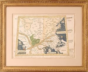
Map. Double-page woodcut map with fine original hand-coloring and Latin place names in letterpress type. Carved gold leaf frame with Amiran anti-reflective archival glass with UV protection. Scale: c.1:4,000,000. Sheet: (15 1/2 x 22 1/4 inches). Frame: (25 1/2 x 32 1/4 inches). A beautiful incunable map of the Balkans, including… Constantinople, from the 1482 Ulm edition of Ptolemy's "Geographia." This map is from the first atlas to be printed north of the Alps and the first with woodcut maps. Here with fine period coloring, including lapis lazuli blue seas, not the ochre color of later editions. This rare incunable is one of the earliest obtainable maps to picture the Balkans. It is from the 1482 Ulm edition of Ptolemy's Geographia, printed by Lienhart Holle and titled Cosmographia, in which Donnus Nicolaus Germanus adapted Ptolemy's second century cartography and added five modern maps. Already political delineations are indicated by color: the Kingdom of Dardania, present-day Kosovo, North Macedonia, Serbia, and Albania, is green, whereas Misia Inferior (eastern Serbia, northern Bulgaria, southern Ukraine, et al) and Iasyes Metanaste are washed in yellow. Ptolemy's map centers Datia, or Roman Dacia, a province of the Roman Empire from 106-275 AD that consisted of Romania and the Banat region. The Carpathian mountains are noted in the north and the Dardanelles are rendered in tan amorphous shapes in the south. In the lower right-hand corner of the map is the tip of Turkey (Asie Minoris Pars) and Constantinople (Istanbul). The Adriactic Sea (Adriatici Pars), Aegean Sea (Maris Egei Pars), and Black Sea (Ponti Evxini Pars) are all captured in luxurious lapis lazuli blue. The 1482 Ulm atlas was a revelation in its manifold innovations: it was the first printed north of the Alps; the first with woodcut maps; the first with maps "signed" by the artist responsible - its world map states "Engraved by Johann, woodcutter from Armszheim" - and his backward "N" was cut into each woodblock used to print the maps; it was the first Ptolemaic atlas with 32 maps; the first to come with publisher's coloring or directions for embellishment; and the first to print text on the verso discussing the map on each corresponding recto. [Shirley] The Cosmographia atlas was the first book printed by Lienhart Holle: a masterful debut. But with its 32 individual hand-colored woodcut maps, all printed with letterpress type, it was very expensive to produce and its publication bankrupted Holle. The remaining sheets, woodblocks, matrices, and type were taken up by another printer in Ulm, Johann Reger, who reissued the work in 1486. Those second edition Reger maps are seen with the less desirable ochre washes over the sea in place of lapis lazuli blue, as here. "Claudius Ptolemaeus is the Latinized name of the geographer and astronomer who is more generally known as Ptolemy and who lived in Alexandria, Egypt, from 90-168 AD. His principal geographic work, the Geographia was transmitted from classical times and was the first atlas to be printed. The text is based on the translation from the Greek by Jacobus Angelus." [Shirley] The five modern maps were based on manuscript projections by the editor of the work, Donnus Nicolaus Germanus, a Benedictine monk from the diocese of Breslau who lived and worked in Florence. Germanus likely invented the trapezoid projection, which became known as the Donis-projection; it allows one to represent a three dimensional, spherical section on a two dimensional page. Campbell concludes that the "major achievement of the Ptolemaic maps was to introduce a formalized grid of longitude and latitude, in conjunction with positions obtained through astronomical observations. By favoring the shortest of various Greek estimates as to the circumference of the earth and arriving at a much reduced value for a degree of longitude, Ptolemy seriously underestimated the distance between western Europe and the supposed position of China." Had Columbu.
Published by Lienhart Holle, Ulm, Germany 1482
- Signed
- Map
Seller: Donald A. Heald Rare Books (ABAA), New York, NY, U.S.A.Donald A. Heald Rare Books (ABAA)
Contact seller5-star sellerCondition: Used
US$ 24,000.00
US$ 25.00 shippingShips within U.S.A.Quantity: 1 available
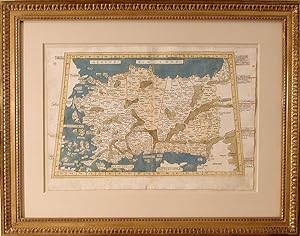
Map. Double-page woodcut map with fine original hand-coloring and Latin place-names in letterpress type. Carved gold leaf frame with Amiran anti-reflective archival glass with UV protection. Scale: c.1:4,000,000. Sheet (15 1/2 x 22 1/4 inches). Frame: (25 1/2 x 32 1/4 inches). This is one of the earliest obtainable maps of Türki…ye. A beautiful incunable from the 1482 Ulm edition of Ptolemy's "Geographia," the first atlas to be printed north of the Alps and the first with woodcut maps. Here with fine period coloring, including lapis lazuli blue seas, not the ochre color of later editions. This rare hand-colored incunable is one of the earliest obtainable maps to picture Türkiye. It is from the 1482 Ulm edition of Ptolemy's Geographia, printed by Lienhart Holle and titled Cosmographia, in which Donnus Nicolaus Germanus adapted Ptolemy's second century cartography and added five modern maps. This Ptolemaic map of Asia Minor depicts an instantly recognizable region, with the Black Sea (Pontvs Evx Invs) to the north, and the Aegean Sea (Egevm Mare) to the west, each captured in luxurious lapis lazuli blue. Significant cities, such as Constantinople (Istanbul), are labeled, and some political boundaries are delineated by color, such as the yellow washes over the two Anatolian provinces of Galatia and Pafflagonia. The Taurus mountain ranges in the south are represented with tan amorphous shapes. The level of detail in this map as opposed to others in the 1482 Ulm conveys the importance of Türkiye to the Mediterranean world of Ptolemy. The 1482 Ulm atlas was a revelation in its manifold innovations: it was the first printed north of the Alps; the first with woodcut maps; the first with maps "signed" by the artist responsible - its world map states "Engraved by Johann, woodcutter from Armszheim" - and his backward "N" was cut into each woodblock used to print the maps; it was the first Ptolemaic atlas with 32 maps; the first to come with publisher's coloring or directions for embellishment; and the first to print text on the verso discussing the map on each corresponding recto. [Shirley] The Cosmographia atlas was the first book printed by Lienhart Holle: a masterful debut. But with its 32 individual hand-colored woodcut maps, all printed with letterpress type, it was very expensive to produce and its publication bankrupted Holle. The remaining sheets, woodblocks, matrices, and type were taken up by another printer in Ulm, Johann Reger, who reissued the work in 1486. Those second edition Reger maps are seen with the less desirable ochre washes over the sea in place of lapis lazuli blue, as here. "Claudius Ptolemaeus is the Latinized name of the geographer and astronomer who is more generally known as Ptolemy and who lived in Alexandria, Egypt, from 90-168 AD. His principal geographic work, the Geographia was transmitted from classical times and was the first atlas to be printed. The text is based on the translation from the Greek by Jacobus Angelus." [Shirley] The five modern maps were based on manuscript projections by the editor of the work, Donnus Nicolaus Germanus, a Benedictine monk from the diocese of Breslau who lived and worked in Florence. Germanus likely invented the trapezoid projection, which became known as the Donis-projection; it allows one to represent a three dimensional, spherical section on a two dimensional page. Campbell concludes that the "major achievement of the Ptolemaic maps was to introduce a formalized grid of longitude and latitude, in conjunction with positions obtained through astronomical observations. By favoring the shortest of various Greek estimates as to the circumference of the earth and arriving at a much reduced value for a degree of longitude, Ptolemy seriously underestimated the distance between western Europe and the supposed position of China." Had Columbus realized the true distance, "it is conceivable that he would never have set out on his first, momentous voyage." [Earliest Printed Maps] Bagro.
Published by Lienhart Holle, Ulm, Germany 1482
- Signed
- Map
Seller: Donald A. Heald Rare Books (ABAA), New York, NY, U.S.A.Donald A. Heald Rare Books (ABAA)
Contact seller5-star sellerCondition: Used
US$ 35,000.00
US$ 25.00 shippingShips within U.S.A.Quantity: 1 available
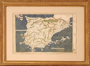
Map. Double-page woodcut map with fine original hand-coloring and Latin place names in letterpress type. Carved gold leaf frame with Amiran anti-reflective archival glass with UV protection. Scale: c.1:4,000,000. Sheet: (15 1/2 x 22 1/4 inches). Frame: (25 1/2 x 32 1/4 inches). A beautiful incunable map of Spain and Portugal fro…m the 1482 Ulm edition of Ptolemy's "Geographia." This map is from the first atlas to be printed north of the Alps and the first with woodcut maps. Here with fine period coloring, including lapis lazuli blue seas, not the ochre color of later editions. This rare incunable map is one of the earliest to picture modern Spain and Portugal. It is from the 1482 Ulm edition of Ptolemy's Geographia, printed by Lienhart Holle and titled Cosmographia, in which Donnus Nicolaus Germanus adapted Ptolemy's second century cartography and added five modern maps, including this one of the Iberian Peninsula. Already political delineations here are indicated by color: the Kingdom of Navarre, centered on Pamplona in the Pyrenees, is colored in green, and a soft yellow wash covers the Kingdom of Portugal. Spain (Hispania) itself is well-articulated, with towns and cities named, and the Pyrenees, Sierra Nevada, and other mountain ranges are represented by amorphous tan shapes. Pictured at the margins are the Le Midi region of France and the northern tip of Morocco, as well as what is now modern Andorra; Gibraltar; Majorca, Menorca, and Ibiza; and Alboran. The islands seen in the top left-hand corner seem to represent the Azores, which should be 700 miles to Portugal's southwest. The Mediterranean Sea (Mare Mediterraneum) and the Atlantic Ocean (Oceanus Occidetalis) are labeled, while the bodies of water we now call the Gulfs of Cadiz and Lion, the Balearic Sea, the Bay of Biscay, and the Strait of Gibraltar are captured in luxurious lapis lazuli blue, but unnamed. The 1482 Ulm atlas was a revelation in its manifold innovations: it was the first printed north of the Alps; the first with woodcut maps; the first with maps "signed" by the artist responsible - its world map states "Engraved by Johann, woodcutter from Armszheim" - and his backward "N" was cut into each woodblock used to print the maps; it was the first Ptolemaic atlas with 32 maps; the first to come with publisher's coloring or directions for embellishment; and the first to print text on the verso discussing the map on each corresponding recto. [Shirley] The Cosmographia atlas was the first book printed by Lienhart Holle: a masterful debut. With its 32 individual hand-colored woodcut maps, all printed with letterpress type, it was expensive to produce and its publication bankrupted Holle. The remaining sheets, woodblocks, matrices, and type were taken up by another printer in Ulm, Johann Reger, who reissued the work in 1486. Those second edition Reger maps are seen with the less desirable ochre washes over the sea in place of lapis lazuli, as here. "Claudius Ptolemaeus is the Latinized name of the geographer and astronomer who is more generally known as Ptolemy and who lived in Alexandria, Egypt, from 90-168 AD. His principal geographic work, the Geographia was transmitted from classical times and was the first atlas to be printed. The text is based on the translation from the Greek by Jacobus Angelus." [Shirley] The five modern maps, of which the present map of the Iberian Peninsula was one, were based on manuscript projections by the editor of the work, Donnus Nicolaus Germanus, a Benedictine monk from the diocese of Breslau who lived and worked in Florence. Germanus likely invented the trapezoid projection, which became known as the Donis-projection; it allows one to represent a three dimensional, spherical section on a two dimensional page. Campbell concludes that the "major achievement of the Ptolemaic maps was to introduce a formalized grid of longitude and latitude, in conjunction with positions obtained through astronomical observations. By favoring the shortes.

Published by Ulm: Johann Reger, 1486. 1486
- Signed
Seller: Arader Galleries - AraderNYC, New York, NY, U.S.A.Arader Galleries - AraderNYC
Contact seller5-star sellerSingle sheet (16 x 22 4/8 inches, image size 11 x 10 2/8 inches). Fine woodcut map of the island of Taprobana, or Ceylon, surrounded by 19 imaginary islands, and erroneously located to the southwest of India, on one side of the sheet, the other being letterpress descriptions of the climate zones, with EXCEPTIONALLY FINE ORIGINAL… HAND-COLOUR in full (central vertical fold, but not crossing the map). This beautiful woodcut map of Taprobana, was the final map in the second edition of Ptolemy's "Cosmographia", published in Ulm in 1486. The island was often overlarge because of its importance to the spice trade between Europe and Southeast Asia, and because of Marco Polo's false claim that the island had a circumference of 2400 miles. There are two mountain ranges that appear on the island, one running vertically in the north with two rivers flowing out of it, and another, perhaps the Knuckles Range, near the center of the island with three rivers emerging from it. Cities and settlements are located as well. The second Ulm edition of Ptolemy's "Cosmographia", was reprinted from Holle's first Ulm edition of 1482. In this edition Reger made certain additions: his Registrum alphabeticum, and an anonymous "De locis et mirabilibus mundi". They must have been popular as they were also inserted in the Rome editions of 1490 and 1507 and 1508. The text of Claudius Ptolemy's "Cosmographia" was translated into Latin from the original Greek by Jacobus Angelus and was first published, in Renaissance times, at Vicenza (1475), Bologna (1477) and Rome (1478). The sumptuous editions published at Ulm in 1482 and 1486, as here, however, far surpassed all earlier efforts and remain two of the most important publications in the history of cartography. They were the first redaction of the 'Geography' to be printed outside of Italy, the earliest atlas printed in Germany, the first to depart from the classical prototype to reflect post-antique discoveries, the first to be illustrated with woodcuts rather than engravings, and the first to contain hand-colored maps, the design and execution of which were ascribed to a named cartographer, and the first to incorporate the five modern maps by Nicolaus Germanus. The Ulm editions, moreover, were the first to depart from the classical prototype by expanding the atlas to reflect post-antique discoveries about the size and shape of the earth. To the canonical twenty-seven Ptolemaic maps were added five "modern maps" of Spain, France, Italy, the Holy Land and northern Europe. The world map is of particular interest as it is the first to be signed, by Johannes Schnitzer of Armsheim, who in trade mark fashion has reversed every capital N, and inadvertently provided two Tropics of Cancer. This map is the first to be based on Ptolemy's second projection, in which both parallels and meridians are shown curved to convey the sphericity of the earth. Schnitzer, furthermore, updated the Ptolemaic world picture by incorporating improvements that were probably based on a manuscript of the 1470s by Nicolaus Germanus (ca 1420-1490), a Benedictine monk of Reichenbach Abbey in Bavaria, who is depicted in the first illuminated letter of the atlas presenting his book to the dedicatee Pope Paul II. Claudius Ptolemy was an Alexandrine Greek, and a dominant figure in both astronomy and geography for more than 1500 years. "He compiled a mapmaker's manual usually referred to simply as the 'Geography'. He demonstrated how the globe could be projected on a plane surface, provided coordinates for over 8,000 places across his the Roman world, and expressed them in degrees of longitude and latitude. No maps drawn by Ptolemy himself are known to survive, but maps compiled from his instructions as outlined in his 'Geography' were circulated from about 1300. Signed by Author(s).
 More images
Tétrabiblos. Präsentationsexemplar des "Club du Livre" für den Handel mit Textauszügen und 11 Original-Lithographien.
Ptolémée, Claude (Claudius Ptolemäus) / Barbault, André (Übers.)
Language: German
- Signed
Seller: Antiquariat Martin Barbian & Grund GbR, Saarbruecken, , GermanyAntiquariat Martin Barbian & Grund GbR
Contact seller5-star sellerCondition: Used
US$ 238.45
US$ 52.09 shippingShips from Germany to U.S.A.Quantity: 1 available
Paris, Club du Livre - Éditeur Pierre Lebaud, 1972, Gr.-4°, 29 Textseiten sowie 11 Original-Farblithographien (1 doppelblattgroße) von Jean Picart Le Doux, geprägter Ganzledereinband von Robert Ardant mit eingelassener Metallplatte * *Im Impressum von Picart handsigniert. *Jean Picart Le Doux (* 31. Januar 1902 - 7. Mai 1982) wa…r ein französischer Künstler, der insbesondere in den Bereichen der Buchillustration und GebrauchsBuch sowie der Malerei und der Bildwirkerei tätig war.


