Rowe Booth John (2 results)

- Hardcover
Seller: Montclair Book Center, Montclair, NJ, U.S.A.Montclair Book Center
Contact seller4-star sellerCondition: Used - Very good
US$ 5.00
US$ 5.99 shippingShips within U.S.A.Quantity: 1 available
Hardcover. Condition: USED Very Good. Barclay, Sue; Berridge, Richard; Booth, John; Brand, Maggie; Cook, David; Deverell, Richard; Gower, Jeremy; Lobban, John; Milne, Annabel; O'Brien, Teresa; Pyke, Jeremy; Rowe, Barry; Tourret, Pat; Visscher, Peter; Willey, Lynne (illustrator).
 More images
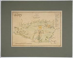
Published by John Booth, Duke Street Portland Place, London 1811
- Softcover
Seller: Antipodean Books, Maps & Prints, ABAA, Garrison, NY, U.S.A.Antipodean Books, Maps & Prints, ABAA
Contact seller3-star sellerCondition: Very good overall. A very scarce lithograph map with period hand color of New South Wales settlements. It was published as the frontispiece of D.D. Mann's "The Present Picture of New South Wales." but this copy was never folded. "Mann's book has a special place in the early literature of Australia. It is the last work… written in the tradition of the First Fleet journalists, although it differs markedly from them. Unlike his predecessors, Mann does not give us a chronological journal but rather a sweeping picture of the development of the colony under Governors Hunter, King and Bligh. As well, Mann was a convict and his book is the first substantial historical work published by a convict" (Wantrup). The map shows the area at the very end of the governor ship of the notorious William Bligh (of the mutiny on the Bounty), which had ended with the Rum Rebellion. The plan shows how the settlements appeared before Macquarie's ambitious program of public works, which included the naming of the 5 Macquarie towns (Richmond, Castlereagh, Pitt Town, Wilberforce and Windsor). In the upper left corner there is a rudimentary outline of the Blue Mountains; this was before the time of the first European crossing of the mountains which opened access to the fertile land beyond, by Blaxland, Lawson and Wentworth in 1813. Includes table: "Reference to Districts" at the right side, which lists Sydney as item "I"; "13,700 Acres Orphan Ground" is designated just north of Parramatta; many plots designated "Common Grant" or "Common Lease". Below the bottom margin: "London: Published by John Booth, Duke Street, Portland Place, July 20th 1810." 13 x 9 1/2"; unfolded paper size 15 x 11 1/2" . Period hand color. Two closed tears right edge of map and one in the bottom margin. Map a trifle dusty and backed on acid free tissue. Tooley plate 171 #240. NLA Bib ID 1253226; Perry & Prescott, 1811.28.

