Seutter C (11 results)
- Hardcover
- Print on Demand
Seller: True World of Books, Delhi, IndiaTrue World of Books
Contact seller5-star sellerLeatherBound. Condition: New. BOOKS ARE EXEMPT FROM IMPORT DUTIES AND TARIFFS; NO EXTRA CHARGES APPLY. LeatherBound edition. Condition: New. Reprinted from 1922 edition. Leather Binding on Spine and Corners with Golden leaf printing on spine. NO changes have been made to the original text. This is NOT a retyped or an ocr'd repri…nt. Illustrations, Index, if any, are included in black and white. Each page is checked manually before printing. Pages: 68 As this print on demand book is reprinted from a very old book, there could be some missing or flawed pages, but we always try to make the book as complete as possible. Fold-outs, if any, are not part of the book. If the original book was published in multiple volumes then this reprint is of only one volume, not the whole set. Sewing binding for longer life, where the book block is actually sewn (smythe sewn/section sewn) with thread before binding which results in a more durable type of binding. Pages: 68 Language: English.
Language: French
Published by Augsbourg 1740
- First Edition
- Map
Seller: BALAGUÉ LLIBRERIA ANTIQUARIA, Santa Coloma de Farners, SpainBALAGUÉ LLIBRERIA ANTIQUARIA
Contact seller5-star sellerCondition: Used - Near fine
US$ 427.48
US$ 34.59 shippingShips from Spain to U.S.A.Quantity: 1 available
Sin Encuadernar. Condition: Muy bien. 1ª Edición. 63 x 53 cm. Iluminado a mano de época.

Published by Augsburg, M. Seutter. (Ca. 1740). 1740
Seller: Daniel Thierstein, Bern, SwitzerlandDaniel Thierstein
Contact seller4-star sellerCondition: Used
US$ 283.88
US$ 40.35 shippingShips from Switzerland to U.S.A.Quantity: 1 available
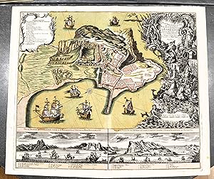
63x58 cm. Grenz- und flächenkolorierte Kupferstichkarte mit Kartusche. Mittelfalz. Sammlung Ryhiner 9654. - Originalausgabe. - Die Karte zeigt die Markgrafschaft Ansbach. Gebiet: Erlangen, Ingolstadt, Augsburg, Schwäbisch Hall. - Ränder etwas angestaubt und lädiert. Sprache: n.

Published by Augsburgo, c.1730 1730
Seller: Librería Antonio Castro, SEVILLA, SpainLibrería Antonio Castro
Contact seller5-star sellerCondition: Used
US$ 759.96
US$ 57.64 shippingShips from Spain to U.S.A.Quantity: 1 available
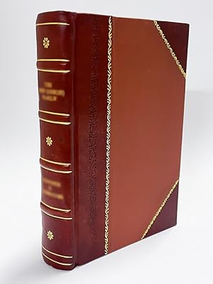
Imagen: 49,5x57,4. Papel: 52x61,5. Impresionante mapa grabado al cobre con color a mano de época. Plano de Gibraltar basado en Harcourt, con gran cartela y leyenda en parte superior izquierda. Abajo, dos vistas del Estrecho, una desde el Mediterráneo y otra desde el Atlántico, con leyendas. Buen estado. Ejemplar que destaca por…su atractivo color. Raro. Albert Seutter, hijo de Georg Matthaeus Seutter produjo relativamente pocos mapas y ningún atlas.

Published by Tobias Conrad Lotter c. 1757, Augsburg 1757
- Map
Seller: Alexandre Antique Prints, Maps & Books, Toronto, CanadaAlexandre Antique Prints, Maps & Books
Contact seller4-star sellerCondition: Used
US$ 1,000.00
US$ 6.00 shippingShips from Canada to U.S.A.Quantity: 1 available
Title cartouche in lower left depicts the shield of Russia, an Imperial solider, and two travelers. The lower right features a small legend., Size : 510x590 (mm), 20.08x23.23 (Inches), Hand Colored in Outline Minor browning along central fold, otherwise Very Good; laid down on acid-free tissue paper for long-term preservation.
Published by Tobias Conrad Lotter c. 1750, Augsburg 1750
Seller: Alexandre Antique Prints, Maps & Books, Toronto, CanadaAlexandre Antique Prints, Maps & Books
Contact seller4-star sellerCondition: Used - Very good
US$ 750.00
US$ 6.00 shippingShips from Canada to U.S.A.Quantity: 1 available
Condition: Very Good. This is a map of the wine region in Saxony, Germany., Size : 500x580 (mm), 19.69x22.83 (Inches), Original Hand Coloring.
 More images
Pagi Basileensis, qui pars esr republicae Helvetiorum cum adjacentibus terrarum tractibus nova eaque accurata mappa geographica concinnata opera et studio Matthaei Seutteri Georgraphi Caesarei Aug. Vindel.
Canton of Basel. - Seutter, Matthäus / T. C. Lotter (Engr.):
Language: Latin
Published by Seutter, Matthäus, Augsburg, 1750 1750
- First Edition
Seller: Antiquariat Carl Wegner, Berlin, GermanyAntiquariat Carl Wegner
Contact seller5-star sellerCondition: Used
US$ 296.86
US$ 10.38 shippingShips from Germany to U.S.A.Quantity: 1 available
Nicht gebunden. 57,5 : 49,5 cm Stichgröße / 60,0 : 53,5 Blattgröße. Altkolorierter Kupferstich von Tobias Conrad Lotter. Unten links im barocken Figuren-Schmuckemblem betitelt, unten rechts eine weitere figürliche Kartusche mit Ansicht der Stadt Basel, darunter mit dem Vermerk: Tob. Conr. Lotter sculps. Auf der Karte verteilt si…eben kleine Wappen. Detaillierte Karte mit alter Grenzkolorierung. Das Blatt im oberen Rand mit bis zu 8 cm reinreichendem alten Feuchtrand. Auch sonst etwas gebräunt. Insgesamt durchaus gut erhalten. -- 57.5 : 49.5 cm engraving size / 60.0 : 53.5 sheet size. Old colored copperplate engraving by Tobias Conrad Lotter. Titled lower left within a baroque figural ornamental emblem, lower right another figural cartouche with a view of the city of Basel, below with the note: Tob. Conr. Lotter sculps. Seven small coats of arms are distributed across the map. Detailed map with old border coloring. The upper margin of the sheet has an old wet margin extending up to 8 cm. Also slightly browned elsewhere. Overall, in very good condition. -- Gravure (57,5 x 49,5 cm) / feuille (60 x 53,5 cm). Ancienne gravure sur cuivre coloriée de Tobias Conrad Lotter. Titrée en bas à gauche dans un emblème ornemental figuratif baroque, en bas à droite dans un autre cartouche figuratif avec une vue de la ville de Bâle, avec la mention en dessous : Tobias Conrad Lotter sculpte. Sept petites armoiries sont réparties sur la carte. Carte détaillée avec ancienne coloration des bordures. La marge supérieure de la feuille présente une ancienne marge humide s'étendant jusqu'à 8 cm. Légèrement brunie ailleurs. En très bon état général. -- Bitte Portokosten außerhalb EU erfragen! / Please ask for postage costs outside EU! / S ' il vous plait demander des frais de port en dehors de l ' UE! // Bitte beachten Sie auch unsere Fotos! / Please also note our photos! / Veuillez noter nos photos -- Nehmen Sie sich ein gutes Buch mit auf die Sommerwiese. Bei uns werden Sie fündig! -- Wir kaufen Ihre werthaltigen Bücher! FL0799-319577.

Language: Latin
Published by Augsburg, Lotter [zwischen 1760/1780] 1780
- Art Print
Seller: Antiquariat Weinek, Salzburg, AustriaAntiquariat Weinek
Contact seller3-star sellerCondition: Used
US$ 374.04
US$ 29.40 shippingShips from Austria to U.S.A.Quantity: 1 available
Altkolorierter Kupferstich. ca. 50 x 59 cm. Vgl. Schaup, S. 115: 3.4.1. - Randläsuren, mit hds. Nr. in linken oberen Ecke, mittig angeklebter Falz a. Rückseite, Gbrsp.
Language: Latin
Published by Augsburg, Ioh. Mart. Will [nach ] 1762
- Art Print
Seller: Antiquariat Weinek, Salzburg, AustriaAntiquariat Weinek
Contact seller3-star sellerCondition: Used
US$ 598.47
US$ 29.40 shippingShips from Austria to U.S.A.Quantity: 1 available
Altkolorierter Kupferstich. ca. 18,7 x 24,5 cm. In illustriertem Orig.-Etui. - Etui rückw. m. hds. Titelei, Gbrsp., Karte etw. fleckig, gefaltet. - Vgl. Schaup 114ff. Aus dem "Atlas Minor." des M. Seutter, die Reisekarten-Ausgabe.
Language: Latin
Published by Augsburg, Ioh. Mart. Will [nach ] 1762
- Art Print
Seller: Antiquariat Weinek, Salzburg, AustriaAntiquariat Weinek
Contact seller3-star sellerCondition: Used
US$ 598.47
US$ 29.40 shippingShips from Austria to U.S.A.Quantity: 1 available
Altkolorierter Kupferstich. ca. 18,7 x 24,5 cm. In illustriertem Orig.-Etui. - Etui rückw. m. hds. Titelei, Gbrsp., Karte etw. fleckig, ein ca. 4 cm Einriss entlang eines Buges, gefaltet. - Vgl. Schaup 114ff. Aus dem "Atlas Minor." des M. Seutter, die Reisekarten-Ausgabe.
- Map
Seller: Angelika C. J. Friebe Ltd. - MapWoman, Dorking, United KingdomAngelika C. J. Friebe Ltd. - MapWoman
Contact seller5-star sellerCondition: Used - Near fine
US$ 1,991.39
US$ 26.67 shippingShips from United Kingdom to U.S.A.Quantity: 1 available
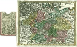
No Binding. Condition: Near Fine. Augsburg c1720 copper engraved prints with original wash colour. overall each 53 x 61 cm, plate 50,5 x 58,5 cm. folds as issued; some rust spots; both sheets: repair to c'folds; top right corners: hand written annotations; o/w exc. cond. This very decorative engraving is printed on two sheets an…d depicts the ranks of dignitaries of the Holy Roman Empire who were able to vote in the Imperial Diet. In the top rank, with the Emperor seated in the middle, are three ecclesiastical to the left and four lay dignitaries to the right. Below are four dukes and four marquesses; in the third and forth rank are four provincial dignitaries four military dignitaries each. The fifth and sixth rank are the burghers and freemen. Below is an explanatory text in Latin and German. This engraving was first published in 1593 in Gerard de Jode's atlas but later, the plates were purchased by Vrients and from 1603 onwards, it appeared in Ortelius' 'Theatrum' as well as in the 'Paragon', with the text box a lot smaller. [ref: 3041].


