Order Total (1 Item Items):
Shipping Destination:

Smith Walter Hadcock Richard Neville (1 results)
Feedback
Skip to main search results
Search filters
Product Type
- All Product Types
- Books (1)
- Magazines & Periodicals (No further results match this refinement)
- Comics (No further results match this refinement)
- Sheet Music (No further results match this refinement)
- Art, Prints & Posters (No further results match this refinement)
- Photographs (No further results match this refinement)
- Maps (No further results match this refinement)
- Manuscripts & Paper Collectibles (No further results match this refinement)
Condition
- All Conditions
- New (No further results match this refinement)
- Used (1)
Binding
- All Bindings
- Hardcover (1)
- Softcover (No further results match this refinement)
Collectible Attributes
- First Edition (No further results match this refinement)
- Signed (No further results match this refinement)
- Dust Jacket (No further results match this refinement)
- Seller-Supplied Images (1)
- Not Print on Demand (1)
Free Shipping
- Free Shipping to U.S.A. (No further results match this refinement)
Seller Rating
-
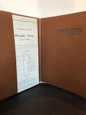
MONASTIC BRITAIN
Published by Ordnance Survey, Southampton, 1978
Seller: Worlds End Bookshop (ABA, PBFA, ILAB), LONDON, United Kingdom
Association Member: ABA ILAB PBFA
Seller rating 4 out of 5 stars

Third edition of the maps, comprising two sheets, 'South Sheets' and 'North Sheet' tucked into a pocket, then 35 pages of explanatory text with an index. Sheet on a scale 1 : 625 000. Pictorial boards. A Fine copy. Shows the geographical distribution and historical development of the monastic houses of Britain (and Scotland) between the Norman Conquest and its suppression in the 16th century. Book.