
Stebbins Henry Map (3 results)

Published by Henry S. Stebbins, Chicago 1881
- Map
Seller: Peninsula Books, Traverse City, MI, U.S.A.Peninsula Books
Contact seller5-star sellerCondition: Used - Very good
US$ 39.95
US$ 7.10 shippingShips within U.S.A.Quantity: 1 available
Map. Condition: Very Good. This map contains both the Upper and Lower Peninsulas and has an inset table on the left side with state counties, number of farms, lands open for settlement, etc. Map shows counties, townships, rivers, cities, towns railroads, Lake Michigan ferries, an inset map of Isle Royal, etc. Single sheet. Fold…lines, as issued; there is a 1/2" tear at the margin of one fold. This appears to have been removed from a Michigan document of some sort. Henry S. Stebbins, Chicago is identified as the engraver. Streeter identifies Henry Stebbins as engraver of one Michigan map prior to 1880. ; B&W Map; 19" x 18".
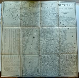
Published by Henry S. Stebbins, Chicago 1883
- Map
Seller: Peninsula Books, Traverse City, MI, U.S.A.Peninsula Books
Contact seller5-star sellerCondition: Used - Very good
US$ 39.95
US$ 7.10 shippingShips within U.S.A.Quantity: 1 available
Map. Condition: Very Good. This map contains both the Upper and Lower Peninsulas and has an inset table on the left side with state counties, number of farms, lands open for settlement, etc. Map shows counties, townships, rivers, cities, towns railroads, Lake Michigan ferries, etc. Single sheet. Fold lines, as issued. This map a…ppears to have been removed from a state document of some sort. Streeter's Michigan Map Bibliography only lists one map by engraver Henry S. Stebbins prior to 1880. ; B&W Map; 22" x 22.25"; 1 sheet pages.
 More images
Published by undated, about 1885 1885
Seller: Up-Country Letters, Gardnerville, NV, U.S.A.Up-Country Letters
Contact seller2-star sellerundated, about 1885, hand-colored, 13 3/4 x 10 1/4 inches. "Prepared for Tappan, McKillop & Co's Bankers and Attorneys Directory". County boundaries are high-lighted; peppered with place names - making it easier to collect debts and file lawsuits within the appropriate jurisdictions. The Tappan and McKillop directory was establi…shed in 1842 and continued until at least 1887. These directories are very rare in the trade. One vertical fold. In Fine condition.


