Order Total (1 Item Items):
Shipping Destination:

Visscher Nicolas (84 results)
Feedback
Skip to main search results
Search filters
Product Type
- All Product Types
- Books (51)
- Magazines & Periodicals (No further results match this refinement)
- Comics (No further results match this refinement)
- Sheet Music (No further results match this refinement)
- Art, Prints & Posters (4)
- Photographs (No further results match this refinement)
- Maps (29)
- Manuscripts & Paper Collectibles (No further results match this refinement)
Condition
Binding
Collectible Attributes
Free Shipping
Seller Rating
-

Savia, natural science, 4 Educación Primaria. Workbook
Published by U.D. Publishing S.A. de C.V., 2015
ISBN 10: 8415743742 ISBN 13: 9788415743743
Paperback. Condition: Brand New. Marquet, Myriam G.; Santos González, José; García Nieto, Pablo; Pérez De Muti, Marcelo; Solís Campos, Fermín; García Ayerbe, Alberto; Santolaya Ruiz Clavijo, Antonia; Archivo De Ediciones SM,; Alonso Rivero, Daniel; Suri,; Muńiz López, Jacobo; Ovejero Sánchez, Ángel; Orbe Ferreiro, Alejandro De; Aguado, Jesús; Nigot Giaux, Marie; Montańá Ros, Marta; León Celma, Pere Lluís; Shutterstock,; Aznar Medina, María Ángeles; Asensio Moruno, Arturo; Muńoz Tenllado, Antonio; Navarro García, José Luis; Wimmer, Sonja; Fernández Prímola, Nicolás; Berdugo Garvia, Guillermo; Moreno Arrastio, Félix; Artimagos, Estudio; Cartanya, Mercé; Tejerina Martínez, Germán (illustrator). Spanish language. 11.42x8.86x0.39 inches. In Stock.
More buying choices from other sellers on AbeBooks
New offers from US$ 22.97
Used offers from US$ 113.45
Also find Softcover
-
Saisie-contrefaçon 2013/2014 - 3e ed.: Dalloz Référence
Published by Dalloz, 2012
ISBN 10: 2247079253 ISBN 13: 9782247079254
Hardcover. Condition: Bon. Ancien livre de bibliothčque. Edition 2012. Ammareal reverse jusqu'ŕ 15% du prix net de cet article ŕ des organisations caritatives. ENGLISH DESCRIPTION Book Condition: Used, Good. Former library book. Edition 2012. Ammareal gives back up to 15% of this item's net price to charity organizations.
-
ausgefaltet ca. 39 x 32 cm. Condition: Sehr gut. Karte Farbiger Nachdruck einer Weltkarte, Unterkante sehr leicht bestoßen, Karte sonst sehr gut erhalten, ohne Jahresangabe, Sprache: Latein Ordner28 la Gewicht in Gramm: 201.
-
S. R. I. Sueviae Circulus Atq. Ducatus Una Cum Insertis et Adjacentibus Regionibus.
Published by Amsterdam, 1705
Seller: BALAGUÉ LLIBRERIA ANTIQUARIA, Santa Coloma de Farners, GIRON, Spain
Seller rating 5 out of 5 stars

Map
Sin Encuadernar. Condition: Papel Algo Cansado. Map of the Baden-Württemberg region of Germany, and northern Switzerland. Relief shown pictorially. Illustrated title cartouche. Con anotaciones manuscritas de época en los márgenes. Coloreado a mano de época. Size: 62,5 x 53,5 Cm.
-
Totius Alsatiae Novissima Tabula, Qua Simul Sundgovia, Brisigavia, Ortenavia, Maxima Pars Marchionatus Badensis, Nec Non Aliae Insertae et Adjacentes Regiones .
Published by Amsterdam, 1677
Seller: BALAGUÉ LLIBRERIA ANTIQUARIA, Santa Coloma de Farners, GIRON, Spain
Seller rating 5 out of 5 stars
Map
Sin Encuadernar. Condition: Papel Cansado. Con anotaciones manuscritas de época en los márgenes. Coloreado a mano de época. (Con un pequeńo roto en el centro) Size: 62 x 53,5 Cm.
-

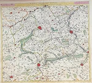
Bavariae Circulus Atq Electoratus Tam Cum Adjancentibus Quam Insertis Regionibus Accuratissime in Suasquasque Ditiones Divisus.
Published by Amsterdam, 1704
Seller: BALAGUÉ LLIBRERIA ANTIQUARIA, Santa Coloma de Farners, GIRON, Spain
Seller rating 5 out of 5 stars
Map
Sin Encuadernar. Condition: Papel Algo Cansado. Con anotaciones manuscritas de época en los márgenes. Coloreado a mano de época. Size: 63 x 53,5 Cm.
-

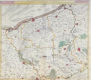
Flandriae Comitatus in Ejusdem Subjacentes Ditiones Accuratissime Divisus Una Cum Adjancetibus.
Published by Amsterdam, 1700
Seller: BALAGUÉ LLIBRERIA ANTIQUARIA, Santa Coloma de Farners, GIRON, Spain
Seller rating 5 out of 5 stars
Map
Sin Encuadernar. Condition: Papel Cansado. This map of the historical region of Flanders traces the coastline from Grevelingen to Zeeland at de Hont oste Westerschelde, south to below Douay, and east to Brussels. Western Belgium. Con anotaciones manuscritas de época en los márgenes. Coloreado a mano de época. Size: 63 x 53 Cm.
-

Portrait of the painter Philip Wouwerman in an elaborate frame including elements recalling subjects usually represented by the painter: horses, hunting scenes a palette with brushes and birds. Lettered in the bottom center: 'PHILIPPUS / WOUWERMAN PICTOR / BATAVUS', signed on the bottom left:'C. de Visscher delineavit' and on the right:'N. Dupuis Sculp.' and in the center:'a Paris chez Huquier vis a vis le grand Chatelet.'l Engraving on paper, trimmed to platemark; total: 424 x 285 mm. Th.B 10, p. 184, Le Blanc 34, Nagler 3 PP01W (Wouwerman) / in black folders A-D [Dupuis].
-
Totius Alsatiae Novissima Tabula, qua simul Sundgovia, Brisigaia, Ortenavia, Marchionatus Badensis
Published by Amsterdam, 1690
Seller: Clive A. Burden Ltd., Chalfont St. Giles, BUCKS, United Kingdom
Seller rating 2 out of 5 stars

Map
No binding. 570 x 465 mm., in early wash colour and in good condition. An attractive map of Alsatia displaying a region of both modern day France and Germany. The River Rhine dissects the map beginning at Philipsburg in the north and extending upriver to Basel and beyond. It bears a beautifully engraved title cartouche, typical of the Dutch mastery of the day. The dating of maps by the Visscher family is difficult but bearing the privilege granted in 1677 we can estimate the date of issue at approximately 1690. An example of the second state with the addition of a reference grid. Koeman (1967-70) III pp. 150-84 no. 91*; Tooley (1999-2004).
-

Totius Alsatiae Novissima Tabula â¦
Published by Amsterdam, 1690
Seller: Clive A. Burden Ltd., Chalfont St. Giles, BUCKS, United Kingdom
Seller rating 2 out of 5 stars
Map
No binding. 570 x 465 mm., in recent wash colour and in good condition. An attractive map of the Alsatia displaying a region of both modern day France and Germany. The River Rhine dissects the map beginning at Philipsburg in the north and extending upriver to Basel and beyond. It bears a beautifully engraved title cartouche typical of the Dutch mastery of the day. The dating of maps by the Visscher family is very hard but bearing the privilege granted in 1677 we can estimate the date of issue at approximately 1690. An example of the second state with the addition of a reference grid. Koeman (1967-70) III pp. 150-84 no. 91*; Tooley (1999-2004).
-
Generalis Lotharingiae Ducatus Tabula .
Published by Amsterdam, 1690
Seller: Clive A. Burden Ltd., Chalfont St. Giles, BUCKS, United Kingdom
Seller rating 2 out of 5 stars
Map
No binding. 465 x 565 mm., in recent wash colour, with minor browning to part of lower margin not affecting the image, in good condition. An attractive map of the Lorraine region. The River Rhine runs in the lower right corner and includes the city of Strassburg. The map is centred on Nancy and includes the city of Metz and to the north Luxembourg. It bears a beautifully engraved title cartouche typical of the Dutch mastery of the day. The dating of maps by the Visscher family is very hard but bearing the privilege granted in 1677 we can estimate the date of issue at approximately 1690. An example of the second state with the addition of a reference grid. Koeman (1967-70) III pp. 150-84 no. 194*; Tooley (1999-2004).
-

Landraviatus Alsatiae Inferioris Novissima Tabula
Published by Amsterdam, 1690
Seller: Clive A. Burden Ltd., Chalfont St. Giles, BUCKS, United Kingdom
Seller rating 2 out of 5 stars
Map
No binding. 465 x 565 mm., early wash colour, in good condition An attractive map of Lower Alsatia displaying a region of both modern day France and Germany. The River Rhine dissects the map beginning at Philipsburg in the north and is centred on Strasbourg. It bears a beautifully engraved title cartouche, typical of the Dutch mastery of the day. The dating of maps by the Visscher family is difficult but bearing the privilege granted in 1677 we can estimate the date of issue at approximately 1690. An example of the second state with the addition of a reference grid. Koeman (1967-70) III pp. 150-84 no. 90*; Tooley (1999-2004).
-
Moguntini Archiepiscopat et Electoratus nec non Comitatum utrisque Cattimeliboci Verthemensis & Erpachiensis.
Published by Amsterdam, 1680
Seller: BALAGUÉ LLIBRERIA ANTIQUARIA, Santa Coloma de Farners, GIRON, Spain
Seller rating 5 out of 5 stars
Map
Sin Encuadernar. Condition: Bueno. Primera edición. Nicolas Visscher (*1618 - 1679). Iluminado a mano de época. Size: 62 x 54 Cm.
-
Carte : Flandriae comitatus pars occidentalis in terram Francam et ejusdem subjacentia officia accuratissima divisa.
Published by Amsterdam, Schenk, (1730)., 1730
Carte 600 x 520 mm. Belle carte des Flandres, de Gravelines ŕ Ypres, de Aire ŕ Furnes. Nombreux de couleurs sur les limites administratives et politiques, les villes et forets. Couleurs époque.
-
Flandriae comitatus pars australis, in castellaniam Insulanam, balliviatum Duacensem, territorium Tornacensem .
Published by Amsterdam, Schenk, (1730)., 1730
Carte 590 x 520 mm. Belle carte en couleurs des Flandres, de Arleux ŕ Menin, de La Bassée ŕ Condé. Couleurs époque.
-
Herder in gesprek met een jonge herder op een ezel (Shepherd talking to a young shepherd on a donkey)
Publication Date: 1670
Seller: Rob Zanger Rare Books LLC, Middletown, NY, U.S.A.
Seller rating 5 out of 5 stars
Etching on handmade, cream laid paper. 5 13/16 x 7 5/8 inches (146 x 192 mm), thread margins. Scattered handling creases, light age tone, and minor paper inconsistoncies throughout. All consistent with age.
-

S.R.I. Sueviae Circulus atq Ducatus .
Published by Amsterdam, 1700
Seller: Clive A. Burden Ltd., Chalfont St. Giles, BUCKS, United Kingdom
Seller rating 2 out of 5 stars
Map
No binding. 480 x 550 mm., recent wash colour. Good condition. A very attractive map of Suabia or southern Germany by Nicolas Visscher. The dating of maps by the Visscher family is very hard but bearing the privilege granted in 1677 and by the style we can ascribe a date to approximately 1700. Tooley's Dictionary.
-
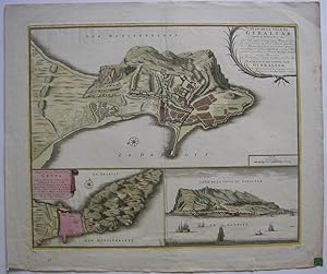
Plan de la Ville de Gibaltar, situé au Detroit de ce Nom. Cette Ville a pris son Nom d`une Montagne qui füt aisi Nom née de Tarik, fameux Capitaine des Maures, qui y posa son premier Camp, c`est pourquoy on l`appela Gibal-Tarik, en Langue Maure, comme qui diroit en Francois Montagne de Tarik en 1706.
Published by Amsterdam, Visscher,, 1706
Seller: Antiquariat Werner Steinbeiß, München, Germany
Seller rating 4 out of 5 stars

dreiteilige altkolorierte Kupferstichkarte mit einem Plan von Gibraltar und Ceuta, rechts unten eine Ansicht der Stadt Gibraltar vom Meer aus, rechts oben Kartusche und Maßstab. - unten kleine Randeinrisse, rückseitig einige Bibliotheks-Stempel bzw. Aufkleber, farbfrisches Exemplar Sprache: Deutsch Gewicht in Gramm: 550 43 x 53 cm Blattgröße 53 x 62,5 cm.
-

Vechtae fundis, villis, praetoriis, atque priscis arcibus triumphantis, Tabula exqisitissima edita a Nic. Vischeri.
Published by Artist: Visscher Nicolas ( - 1679 ) Amsterdam ; issued in: Amsterdam; - Nicolaes Visscher I (1618 -1679) Amsterdam was a Dutch engraver cartographer and publisher He belonged to the Dutch art dealer engraver and publisher dynasty founded by his father Claes Janszoon Visscher After his father's death in 1652 he took over his father's art publishing house and initially continued publishing the atlases and maps that his father had begun He then began publishing works under his own name Together with his son Nicolaes Visscher II (1649-1702) he engraved a large number of printing plates further replenishing the publisher's stock The atlases "Atlas Contractus" "Atlas Minor" and "Germania Inferior" contain about 170 plates After N Visscher's death, 1618
Seller: Antique Sommer& Sapunaru KG, München, Germany
Seller rating 4 out of 5 stars
Art / Print / Poster
Technic: Copper print, colorit: original colored, condition: Very good, size (in cm): 32 x 21; - Titlepage of N. Vischer,Vechtae fundis; History: The title page is one of the most important parts of the "front matter" or "preliminaries" of a book, as the data on it and its verso (together known as the "title leaf") are used to establish the "title proper and usually, though not necessarily, the statement of responsibility and the data relating to publication".This determines the way the book is cited in library catalogs and academic references. The title page often shows the title of the work, the person or body responsible for its intellectual content, and the imprint, which contains the name and address of the book's publisher and its date of publication. Particularly in paperback editions it may contain a shorter title than the cover or lack a descriptive subtitle. Further information about the publication of the book, including its copyright information, is frequently printed on the verso of the title page. The first printed books, or incunabula, did not have title pages: the text simply begins on the first page, and the book is often identified by the initial words?the incipit?of the text proper. Maps were usually published in atlases. And atlases were books with titles. And, again, titles were individual pieces of art. A publisher emphazised the importance of a book he published with a spectacular entrée. Usually the pictures of an atlas title page pertained in general to the subject matter: Measuring instruments, mythologigal, astronomical, religious, scientific, allegorical hints and facts were united in a composition which depicted the pride of progress in knowledge. An atlas title page often is just one superb artistic and jubilant cartouche.
-
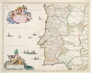
Portugalliae et Algarbiae Regna.
Publication Date: 1680
Seller: Altea Antique Maps, London, United Kingdom
Association Member: ABA ILAB PBFA
Seller rating 5 out of 5 stars
Map
Amsterdam, c.1680. Original colour. 505 x 530mm. Repairs to centre fold. A fine map of Portugal with decorative cartouches for the title and scale, both in full colour.
-
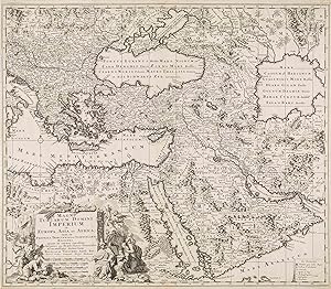
Magni Turcarum Domini Imperium in Europa, Asia et Africa; tam in Proprias, Tributarias, ac Clientelares Regiones, quam in omnes
Published by Nicolas Visscher, Amsterdam, 1679
Map
No Binding. Condition: Very Good. Engraving 50 x 57.5 cm. A very good copy of a map of the Turkish Empire by Nicolaes Visscher I, a renowned Dutch engraver, cartographer, and publisher.
-

Manica Gallis La Manche et Belgis Het Canaal pars Oceani.
Published by Amsterdam, c.1657. 475 x 565mm (18ľ x 22Ľ inches)., 1657
Seller: Tooley, Adams & Co., Wallingford, OXON, United Kingdom
Seller rating 5 out of 5 stars
Original colour; light age-toning, slightly darker in the margins due to framing in the past, tape on verso from a previous frame, light soiling due to inking of the plate, otherwise a very good example. A highly decorative chart of the English Channel, shows Southern England and Northern France. Decorative figured cartouche bottom right.
-

Peregrinatie ofte Veertich-iarige Reyse der Kinderen Israels uyt Egipten, door de Roode- zee; .
Published by [Amsterdam, c.1650]. 307 x 486mm (12 x 19Ľ inches)., 1650
Seller: Tooley, Adams & Co., Wallingford, OXON, United Kingdom
Seller rating 5 out of 5 stars
Uncoloured; dark impression, trimmed close on both sides with enough margin to facilitate framing, minor marginal spotting and toning, otherwise a very good example. Although Laor sites examples of the Visscher map from Bibles and some engraved by Daniel Stoopendaal, this example does not appear to be listed. The map itself is the same as other slightly smaller issues. The maps shows Moses leading the Israelites on the Exodus. Dutch text to both sides of verso, from a Dutch Bible. LAOR: 807, with minor differences.
-
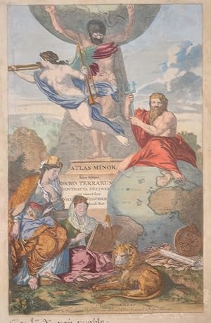
Atlas Minor Sive totius Orbis Terrarum Contracta delineat ex conatibus
Published by Artist: Visscher Nicolas ( - 1679 ) Amsterdam ; issued in: Amsterdam; - Nicolaes Visscher I (1618 -1679) Amsterdam was a Dutch engraver cartographer and publisher He belonged to the Dutch art dealer engraver and publisher dynasty founded by his father Claes Janszoon Visscher After his father's death in 1652 he took over his father's art publishing house and initially continued publishing the atlases and maps that his father had begun He then began publishing works under his own name Together with his son Nicolaes Visscher II (1649-1702) he engraved a large number of printing plates further replenishing the publisher's stock The atlases "Atlas Contractus" "Atlas Minor" and "Germania Inferior" contain about 170 plates After N Visscher's death, 1618
Seller: Antique Sommer& Sapunaru KG, München, Germany
Seller rating 4 out of 5 stars
Art / Print / Poster
Technic: Copper print, colorit: original colored, condition: Margins lightly stained, size (in cm): 39 x 25 cm; - Title page of "Atlas Minor Sive totius Orbis Terrarum Contracta delineat ex conatibus Nicolas Visscher". It shows allegorical representations and the globe with Africa, partly Europe and South America.; History: The title page is one of the most important parts of the "front matter" or "preliminaries" of a book, as the data on it and its verso (together known as the "title leaf") are used to establish the "title proper and usually, though not necessarily, the statement of responsibility and the data relating to publication".This determines the way the book is cited in library catalogs and academic references. The title page often shows the title of the work, the person or body responsible for its intellectual content, and the imprint, which contains the name and address of the book's publisher and its date of publication. Particularly in paperback editions it may contain a shorter title than the cover or lack a descriptive subtitle. Further information about the publication of the book, including its copyright information, is frequently printed on the verso of the title page. The first printed books, or incunabula, did not have title pages: the text simply begins on the first page, and the book is often identified by the initial words?the incipit?of the text proper. Maps were usually published in atlases. And atlases were books with titles. And, again, titles were individual pieces of art. A publisher emphazised the importance of a book he published with a spectacular entrée. Usually the pictures of an atlas title page pertained in general to the subject matter: Measuring instruments, mythologigal, astronomical, religious, scientific, allegorical hints and facts were united in a composition which depicted the pride of progress in knowledge. An atlas title page often is just one superb artistic and jubilant cartouche.
-

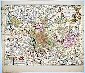
Bavaria ducatus
Published by Artist: Visscher Nicolas ( - 1679 ) Amsterdam ; issued in: Amsterdam; - Nicolaes Visscher I (1618 -1679) Amsterdam was a Dutch engraver cartographer and publisher He belonged to the Dutch art dealer engraver and publisher dynasty founded by his father Claes Janszoon Visscher After his father's death in 1652 he took over his father's art publishing house and initially continued publishing the atlases and maps that his father had begun He then began publishing works under his own name Together with his son Nicolaes Visscher II (1649-1702) he engraved a large number of printing plates further replenishing the publisher's stock The atlases "Atlas Contractus" "Atlas Minor" and "Germania Inferior" contain about 170 plates After N Visscher's death, 1618
Seller: Antique Sommer& Sapunaru KG, München, Germany
Seller rating 4 out of 5 stars
Technic: Copper print, colorit: original colored, condition: Restoration at centerfold, lower missing part replaced, size (in cm): 38 x 49; - Map shows Upper Bavaria with Munich, Augsburg, Regensburg, Landshut, Passau, Tegernsee, Berchdesgaden, Kufstein, Salzburg etc. and a title cartouche.; History: The existence of a Bavarian tribal duchy has been documented since 555, which became part of the Frankish domain under the Merovingians. From 1180 to 1918 Bavaria was ruled by the Wittelsbachers as a territorial duchy. Bavaria experienced a period of numerous divisions into individual duchies from 1255 to 1503. Shortly before the first reunification, Ludwig IV. In 1328 became the first Wittelsbacher to become emperor, which meant a new high point in power for Bavaria. At the same time, however, the prince-archbishopric of Salzburg finally separated from the mother country Bavaria. In 1429, after the Straubing-Holland line became extinct, the Duchy of Bavaria-Straubing was divided between the Munich, Ingolstadt and Landshut lines. In 1447, Bavaria-Ingolstadt fell to Bavaria-Landshut, which in turn was won by Bavaria-Munich in the War of Succession in Landshut in 1503. The division of the country came to an end through the Primogenitur Act of Duke Albrecht IV of 1506. Bavaria took a leading position in the Counter-Reformation and emerged from the Thirty Years' War with territorial gains and the rise to the Electorate. In 1620, the troops of the Catholic League, under the leadership of the Bavarian general Tilly, defeated the Protestants in the Battle of the White Mountains near Prague. Then Tilly had the Palatinate occupied. As a thank you, Maximilian I received the electoral title in 1623 and the Upper Palatinate he occupied as war compensation in 1628. After the war, Elector Ferdinand Maria devoted himself to the reconstruction of the devastated country and pursued a cautious neutrality policy. During the War of the Spanish and Austrian Succession and in the course of Maximilian II. Emanuel's great power policy and later his son Karl Albrecht, Austria was twice temporarily occupied by absolutist Bavaria. In 1705 the Bavarian people rose against the imperial occupation. Only the battle of Aidenbach on January 8, 1706 ended with the complete defeat of the popular uprising. After Karl Albrecht's coronation, large parts of the electorate were occupied again until 1744. Karl Albrecht's son Maximilian III. Joseph finally ended the great power policy of his predecessors in 1745 and devoted himself to internal reforms. After the extinction of the old Bavarian line of the Wittelsbacher, the double electorate of Kurpfalz-Bavaria was created in 1777 under the reign of the Elector Karl Theodor from the Palatinate line of the Wittelsbacher. At the time of Napoleon, Bavaria was initially on the side of France and was able to record large territorial gains through secularization and mediatization. Salzburg, Tyrol, Vorarlberg and the Innviertel region, which was lost in 1779, fell temporarily to Bavaria. In the Peace of Pressburg, which was concluded on December 26, 1805 between France and the German Emperor Franz II, Bavaria, allied with Napoleon, was proclaimed a kingdom. King Max I. Joseph's Minister Maximilian Graf von Montgelas is considered the creator of the modern Bavarian state. In 1806 Napoleon Bonaparte elevated Bavaria to a kingdom. At the Vienna Congress in 1814, Bavaria was able to retain a large part of the area's profits as a victorious power, including what was now northern Bavaria, parts of Swabia and the Palatinate. In 1918 the Wittelsbach monarchy collapsed in the November Revolution. King Ludwig I, who had ruled since 1825, developed the Bavarian capital Munich into an art and university city. After the occupation by American troops, Bavaria became part of the newly founded Federal Republic in 1949.
-
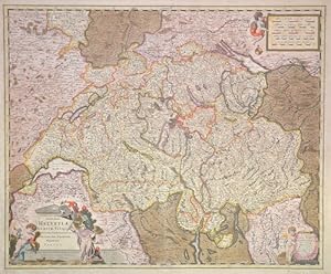
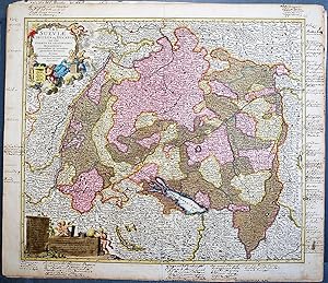
Exactißima Helvetiae Rhaetiae, Valesia Ceterorumque, Confoederatorum ut et finitimorum Populorum Regionum Tabula.
Published by Artist: Visscher Nicolas ( - 1679 ) Amsterdam ; issued in: Amsterdam; - Nicolaes Visscher I (1618 -1679) Amsterdam was a Dutch engraver cartographer and publisher He belonged to the Dutch art dealer engraver and publisher dynasty founded by his father Claes Janszoon Visscher After his father's death in 1652 he took over his father's art publishing house and initially continued publishing the atlases and maps that his father had begun He then began publishing works under his own name Together with his son Nicolaes Visscher II (1649-1702) he engraved a large number of printing plates further replenishing the publisher's stock The atlases "Atlas Contractus" "Atlas Minor" and "Germania Inferior" contain about 170 plates After N Visscher's death, 1618
Seller: Antique Sommer& Sapunaru KG, München, Germany
Seller rating 4 out of 5 stars
Technic: Copper print, colorit: original colored, condition: , size (in cm): 46,5 x 56,5 cm; - Princely map edition of Switzerland with three partially qouached cartouches. - additional information: Royal edition, heightened with gold; History: Since 1848, the Swiss Confederation has been a federal state of relatively autonomous cantons, some of which have a history of confederacy that goes back more than 700 years, putting them among the world's oldest surviving republics. The early history of the region is tied to that of Alpine culture. Switzerland was inhabited by Gauls and Raetians, and it came under Roman rule in the 1st century BC. Gallo-Roman culture was amalgamated with Germanic influence during Late Antiquity, with the eastern part of Switzerland becoming Alemannic territory. The area of Switzerland was incorporated into the Frankish Empire in the 6th century. In the high medieval period, the eastern part became part of the Duchy of Swabia within the Holy Roman Empire while the western part was part of Burgundy.
-
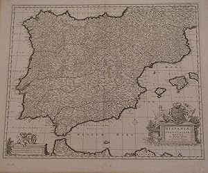
Hispaniae et Portugalliae regna. Per Nicolaum Visfcher. Cum privilegio ordinum Hollandia et Westfrisia.
Published by Amsterdam, 1680., 1680
Seller: Librería Antonio Castro, SEVILLA, SE, Spain
Seller rating 4 out of 5 stars
Huella: 47x57. Papel: 53x63. Impresionante mapa de Espańa y Portugal, con parte de la costa africana. Grabado al cobre. Con cartela y escala muy decorativas. Muy buen ejemplar. Bella impresión.
-

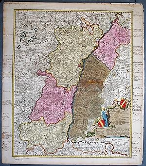
Landgraviatus Alsatiae Inferioris Novissima Tabula, in qua simul Marchionatus Badensis, Ortenavia Caeteraqtam Lotharingica quam alia Confinia,
Published by Artist: Visscher Nicolas ( - 1679 ) Amsterdam ; issued in: Amsterdam; - Nicolaes Visscher I (1618 -1679) Amsterdam was a Dutch engraver cartographer and publisher He belonged to the Dutch art dealer engraver and publisher dynasty founded by his father Claes Janszoon Visscher After his father's death in 1652 he took over his father's art publishing house and initially continued publishing the atlases and maps that his father had begun He then began publishing works under his own name Together with his son Nicolaes Visscher II (1649-1702) he engraved a large number of printing plates further replenishing the publisher's stock The atlases "Atlas Contractus" "Atlas Minor" and "Germania Inferior" contain about 170 plates After N Visscher's death, 1618
Seller: Antique Sommer& Sapunaru KG, München, Germany
Seller rating 4 out of 5 stars
Technic: Copper print, colorit: original colored, condition: Perfect condition, size (in cm): 46 x 56 cm; - Map shows the whole of Alsace in France with Strasbourg, Wissembourg, Sélestat (German: Schlettstadt), Saverne (German: Zabern), Hagenau and many more. Furthermore, a title cartouche with women, child and a cornucopia, the mythological symbol of happiness.; History: The area around the Moselle, populated mainly by Celtic tribes, was conquered by Gaius Iulius Caesar in the Gallic War between 58 and 51 BC and later became part of the Roman province of Gallia Belgica. From a division of the Frankish Empire into three parts, the Lotharii Regnum, the "Empire of Lothar" or Lotharingia, named after its king, emerged in 843. s lay in the middle between the East and West Frankish Empires and originally stretched as an elongated territory from the Mediterranean to the North Sea. In 870, the area was again divided between the East and West Frankish Empires.
-

Luxemburgensis Ducatus, tam in ejusdem minores, quam principales Ditiones peraccurate Distinctus,.
Published by Artist: Visscher Nicolas ( - 1679 ) Amsterdam ; issued in: Amsterdam; - Nicolaes Visscher I (1618 -1679) Amsterdam was a Dutch engraver cartographer and publisher He belonged to the Dutch art dealer engraver and publisher dynasty founded by his father Claes Janszoon Visscher After his father's death in 1652 he took over his father's art publishing house and initially continued publishing the atlases and maps that his father had begun He then began publishing works under his own name Together with his son Nicolaes Visscher II (1649-1702) he engraved a large number of printing plates further replenishing the publisher's stock The atlases "Atlas Contractus" "Atlas Minor" and "Germania Inferior" contain about 170 plates After N Visscher's death, 1618
Seller: Antique Sommer& Sapunaru KG, München, Germany
Seller rating 4 out of 5 stars
Technic: Copper print, colorit: original colored, condition: Margin replaced with lower missing part, size (in cm): 49 x 58,5; - Decorative map of Luxembourg with its surrounding countries.; History: Officially the Grand Duchy of Luxembourg,in the 14th and early 15th centuries, three members of the House of Luxembourg reigned as Holy Roman Emperors. In 1437, the House of Luxembourg suffered a succession crisis, precipitated by the lack of a male heir to assume the throne, which led to the territories being sold by Duchess Elisabeth to Philip the Good of Burgundy. In the following centuries, Luxembourg's fortress was steadily enlarged and strengthened by its successive occupants, the Bourbons, Habsburgs, Hohenzollerns and the French.
-
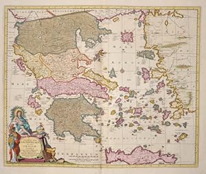
Exactissima totius Archipelagi nec non Graeciae Tabula
Published by Artist: Visscher Nicolas ( - 1679 ) Amsterdam ; issued in: Amsterdam; - Nicolaes Visscher I (1618 -1679) Amsterdam was a Dutch engraver cartographer and publisher He belonged to the Dutch art dealer engraver and publisher dynasty founded by his father Claes Janszoon Visscher After his father's death in 1652 he took over his father's art publishing house and initially continued publishing the atlases and maps that his father had begun He then began publishing works under his own name Together with his son Nicolaes Visscher II (1649-1702) he engraved a large number of printing plates further replenishing the publisher's stock The atlases "Atlas Contractus" "Atlas Minor" and "Germania Inferior" contain about 170 plates After N Visscher's death, 1618
Seller: Antique Sommer& Sapunaru KG, München, Germany
Seller rating 4 out of 5 stars
Technic: Copper print, colorit: original colored, condition: Very good, size (in cm): 46 x 56 cm; - Map shows the whole of Greece, the Aegean Sea and the island of Crete with two magnificent cartouches.; History: Greece is considered the cradle of Western civilisation, being the birthplace of democracy, Western philosophy, Western literature, historiography, political science, major scientific and mathematical principles, Western drama and the Olympic Games. From the eighth century B.C., the Greeks were organised into various independent city-states, known as poleis (singular polis), which spanned the entire Mediterranean region and the Black Sea. Philip of Macedon united most of the Greek mainland in the fourth century BC, with his son Alexander the Great rapidly conquering much of the ancient world, from the eastern Mediterranean to India. Greece was annexed by Rome in the second century B.C., becoming an integral part of the Roman Empire and its successor, the Byzantine Empire, which adopted the Greek language and culture. The Greek Orthodox Church, which emerged in the first century A.D., helped shape modern Greek identity and transmitted Greek traditions to the wider Orthodox World. After falling under Ottoman dominion in the mid-15th century, Greece emerged as a modern nation state in 1830 following a war of independence.