Order Total (1 Item Items):
Shipping Destination:

William Hemsley Emory (73 results)
Skip to main search results
Search filters
Product Type
- All Product Types
- Books (73)
- Magazines & Periodicals (No further results match this refinement)
- Comics (No further results match this refinement)
- Sheet Music (No further results match this refinement)
- Art, Prints & Posters (No further results match this refinement)
- Photographs (No further results match this refinement)
- Maps (No further results match this refinement)
- Manuscripts & Paper Collectibles (No further results match this refinement)
Condition Learn more
- New (34)
- As New, Fine or Near Fine (No further results match this refinement)
- Very Good or Good (9)
- Fair or Poor (No further results match this refinement)
- As Described (30)
Binding
Collectible Attributes
- First Edition (15)
- Signed (No further results match this refinement)
- Dust Jacket (No further results match this refinement)
- Seller-Supplied Images (51)
- Not Print on Demand (52)
Language (2)
Free Shipping
Seller Location
Seller Rating
-
PAP. Condition: New. New Book. Shipped from UK. Established seller since 2000.
-
Report on the United States and Mexican Boundary Survey, Made Under the Direction of the Secretary of the Interior, Vol. 1 (Classic Reprint)
Seller: PBShop.store UK, Fairford, GLOS, United Kingdom
Seller rating 4 out of 5 stars

US$ 26.73
US$ 5.51 shipping
Ships from United Kingdom to U.S.A.Quantity: 15 available
Add to basketPAP. Condition: New. New Book. Shipped from UK. Established seller since 2000.
-

PAP. Condition: New. New Book. Shipped from UK. Established seller since 2000.
-
HRD. Condition: New. New Book. Shipped from UK. Established seller since 2000.
-
Notes of a Military Reconnoissance, from Fort Leavenworth, in Missouri, to San Diego, in California
Seller: PBShop.store UK, Fairford, GLOS, United Kingdom
Seller rating 4 out of 5 stars
US$ 31.74
US$ 6.64 shipping
Ships from United Kingdom to U.S.A.Quantity: 15 available
Add to basketPAP. Condition: New. New Book. Shipped from UK. Established seller since 2000.
-
PAP. Condition: New. New Book. Shipped from UK. Established seller since 2000.
-
Report on the United States and Mexican Boundary Survey, Made Under the Direction of the Secretary of the Interior, Vol. 1 (Classic Reprint)
Seller: PBShop.store UK, Fairford, GLOS, United Kingdom
Seller rating 4 out of 5 stars
US$ 33.42
US$ 6.64 shipping
Ships from United Kingdom to U.S.A.Quantity: 15 available
Add to basketHRD. Condition: New. New Book. Shipped from UK. Established seller since 2000.
-
Report on the United States and Mexican Boundary Survey, Vol. 1
Seller: PBShop.store UK, Fairford, GLOS, United Kingdom
Seller rating 4 out of 5 stars
US$ 33.38
US$ 7.77 shipping
Ships from United Kingdom to U.S.A.Quantity: 15 available
Add to basketPAP. Condition: New. New Book. Shipped from UK. Established seller since 2000.
-
HRD. Condition: New. New Book. Shipped from UK. Established seller since 2000.
-
Notes of a Military Reconnoissance, From Fort Leavenworth, in Missouri, to San Diego, in California: Including Part of the Arkansas, Del Norte, and Gila Rivers (Classic Reprint)
Seller: PBShop.store UK, Fairford, GLOS, United Kingdom
Seller rating 4 out of 5 stars
US$ 38.18
US$ 7.77 shipping
Ships from United Kingdom to U.S.A.Quantity: 15 available
Add to basketHRD. Condition: New. New Book. Shipped from UK. Established seller since 2000.
-
HRD. Condition: New. New Book. Shipped from UK. Established seller since 2000.
-
Report on the United States and Mexican Boundary Survey, Vol. 1: Made Under the Direction of the Secretary of the Interior (Classic Reprint)
Seller: PBShop.store UK, Fairford, GLOS, United Kingdom
Seller rating 4 out of 5 stars
US$ 39.83
US$ 8.95 shipping
Ships from United Kingdom to U.S.A.Quantity: 15 available
Add to basketHRD. Condition: New. New Book. Shipped from UK. Established seller since 2000.
-
US$ 20.40
Free Shipping
Ships from United Kingdom to U.S.A.Quantity: Over 20 available
Add to basketPaperback. Condition: New. Print on Demand. Embark on a captivating journey through the diverse landscapes of the United States-Mexico borderlands in the mid-19th century. This book offers a detailed exploration of the region's geological formations, physical features, and natural resources, painting a vivid picture of a land shaped by volcanic activity, sedimentary deposits, and the forces of erosion. The author's meticulous observations, interwoven with insights from accompanying geologists and naturalists, transport readers to a time of exploration and discovery. From the expansive tablelands of Texas to the rugged peaks of the Sierra Madre, the narrative unveils the geological history and unique characteristics of this dynamic region. Encounter the challenges and wonders faced by early travelers, including encounters with indigenous communities and the search for precious minerals. Delve into discussions on the formation of mountain ranges, the significance of fossils, and the impact of geological processes on the region's flora and fauna. The book's exploration of the borderlands extends beyond mere physical description, offering reflections on the interplay between human activity and the natural environment. Ultimately, this book provides a valuable historical record and a testament to the enduring power of scientific inquiry in unraveling the mysteries of the land. This book is a reproduction of an important historical work, digitally reconstructed using state-of-the-art technology to preserve the original format. In rare cases, an imperfection in the original, such as a blemish or missing page, may be replicated in the book. print-on-demand item.
-
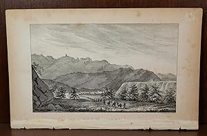
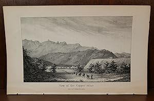
This lithograph is the view of copper mine from the Emory expedition to New Mexico and California. Titled View of the Copper Mine". Measuring approximately 8.75" x 5.5". This lithograph is in good condition. Minor chipping around edges from binding. Minor staining around edges. Please view the many other rare titles available for purchase at our store. We are always interested in purchasing individual or collections of fine books. Inventory #(O2-38).
-
US$ 24.99
Free Shipping
Ships from United Kingdom to U.S.A.Quantity: Over 20 available
Add to basketPaperback. Condition: New. Print on Demand. This book chronicles the route taken by Lieutenant Emory as he traveled from Ft. Leavenworth, Missouri, to San Diego, California, in 1846. Lieutenant Emory accompanied Colonel Kearney and his dragoons to survey the Southwestern territories at a time when the U.S. was at war with Mexico. The author provides a detailed account of the terrain and wildlife encountered, as well as an insightful look at the indigenous peoples and Mexican settlers living along the route. This book is a valuable resource for scholars and researchers interested in the history, geography, and natural resources of the American Southwest, at a time of great change and conflict. This book is a reproduction of an important historical work, digitally reconstructed using state-of-the-art technology to preserve the original format. In rare cases, an imperfection in the original, such as a blemish or missing page, may be replicated in the book. print-on-demand item.
-
US$ 26.59
Free Shipping
Ships from United Kingdom to U.S.A.Quantity: Over 20 available
Add to basketPaperback. Condition: New. Print on Demand. This book delves into a significant chapter of American history, offering a firsthand account of the tumultuous process of surveying and establishing the boundary between the United States and Mexico following the Mexican-American War and the subsequent Gadsden Purchase. The author, a key figure in this undertaking, navigates the complexities of diplomacy, logistics, and the challenges of traversing uncharted and often hostile terrain. The narrative unfolds against the backdrop of a rapidly changing nation, grappling with the implications of westward expansion, the discovery of gold in California, and ongoing tensions with indigenous populations. The author's personal account sheds light on the intricate political landscape of the time, exposing bureaucratic inefficiencies, funding challenges, and interpersonal conflicts that threatened the project's success. Amidst these obstacles, the book underscores the unwavering dedication of the survey team and their commitment to scientific accuracy and diplomatic integrity. Through vivid descriptions and meticulous detail, the author illuminates the geographical diversity, cultural encounters, and the sheer scale of the endeavor. The reader gains a profound understanding of the challenges and triumphs associated with defining national borders, and the lasting impact of this process on the shaping of the American Southwest. Ultimately, this book offers a compelling testament to human resilience, scientific exploration, and the enduring quest for order amidst the uncertainties of a nation in flux. This book is a reproduction of an important historical work, digitally reconstructed using state-of-the-art technology to preserve the original format. In rare cases, an imperfection in the original, such as a blemish or missing page, may be replicated in the book. print-on-demand item.
-

US$ 27.50
Free Shipping
Ships from United Kingdom to U.S.A.Quantity: Over 20 available
Add to basketPaperback. Condition: New. Print on Demand. This book is a reproduction of an important historical work, digitally reconstructed using state-of-the-art technology to preserve the original format. In rare cases, an imperfection in the original, such as a blemish or missing page, may be replicated in the book. print-on-demand item.
-
Lot of 2 lithographs of San Felippe Pueblo New Mexico from 1848. 30 miles north of Albuquerque. Measuring approximately 8.75" x 5.5". This lithograph is in good condition. Minor chipping around edges from binding. Minor staining around edges. Please view the many other rare titles available for purchase at our store. We are always interested in purchasing individual or collections of fine books. Inventory #(O2-35).
-
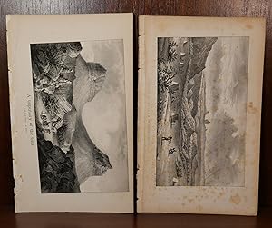
These 3 lithographs from 1848 are titled "Hicrogliphics", "Pimos & Coco Maricopas Indians". Measuring approximately 8.75" x 5.5". These lithographs are in good condition. Minor chipping on the edge where they were in the binding. Moderate spotting around edges. Please view the many other rare titles available for purchase at our store. We are always interested in purchasing individual or collections of fine books. Inventory #(O2-38).
-
This lithograph is the view of copper mine from the Emory expedition to New Mexico and California. Titled View of the Copper Mine". Measuring approximately 8.75" x 5.5". This lithograph is in good condition. Minor chipping around edges from binding. Please view the many other rare titles available for purchase at our store. We are always interested in purchasing individual or collections of fine books. Inventory #(O2-39).
-
Lithograph of "Pimos & Coco Maricopas Indians". Measuring approximately 8.75" x 5.5. This lithograph is in very good condition. Moderate staining to all edges. Bright and detailed lithograph. Please view the many other rare titles available for purchase at our store. We are always interested in purchasing individual or collections of fine books. Inventory #(O2-40).
-

US$ 155.43
US$ 33.09 shipping
Ships from United Kingdom to U.S.A.Quantity: 1 available
Add to basketpaperback. Condition: New. NEW. SHIPS FROM MULTIPLE LOCATIONS. book.
-
Notes of a Military Reconnoissance, from Fort Leavenworth, in Missouri, to San Diego, in California, Including Part of the Arkansas, Del Norte, and Gila Rivers
Language: English
Published by Wendell and Van Benthuysen, Washington, 1848
First Edition
This rare first Senate edition of Notes of a Military Reconnaissance by Lt. Col. William Hemsley Emory documents one of the most critical overland journeys of the U.S. Army during the Mexican-American War. Emory's detailed observations as a trained topographical engineer and naturalist while accompanying the Army of the West offer significant early scientific data on the geography, wildlife, and Native American tribes of the American Southwest. The route Emory charted would later support the rationale for the Gadsden Purchase while also being a popular travel route during the California Gold Rush. Widely regarded as an essential foundation for any Western Americana collection, it includes 43 engraved plates, including 3 full-page maps of battles from the Mexican-American War. Handwritten signature of [Dr. L. McKraken] on front flyleaf. Octavo (8vo), single volume. Good condition; modern brown cloth binding is tight and sound without wear, while pages and plates show extensive foxing, though the text is legible, and wanting folding map. Collation: 416 pp. Illustrations: 43 engraved plates including 3 full-page maps; wanting folding map. Edition: Washington, Wendell and Van Benthuysen. First edition, 1848. References: Graff 1249; Howes E 145; Sabin 22536; Wagner-Camp 148-5; Zamorano Eighty 33. #31155. PHOTOS AVAILABLE UPON REQUEST.
-
Notes of a Military Reconnoissance, from Fort Leavenworth, in Missouri, to San Diego, in California ; including parts of the Arkansas, Del Norte, and Gila Rivers.
Language: English
Published by Wendell and Van Benthuysen, Printers, Washington, 1848
Seller: Librairie Voyage et Exploration, Cerny, France
Seller rating 3 out of 5 stars

First Edition
Washington, Wendell and Van Benthuysen, Printers, 1848. Octavo. xvi, 416 pages. Contemporary half calf, smooth spine gilt with author and title, red edges, stamp on title. Hinge cracked, small loose and label on spine. Large folding map detached and showing browning along the folds. First edition, Senate issue. 30th Congress, 1st Session, Senate, Executive No. 7. Illustrated with 43 plates, including three battle plans of the Mexican-American War (among them the Battle of Pueblo de Los Angeles), early views of California settlements (including San Diego), ethnographic portraits, and botanical plates, and accompanied by the large folding engraved map (33 � 75 inches, environ 84x190cm) The report documenting the military reconnaissance conducted in 1846-1847 during the Mexican-American War by Lieutenant-Colonel William H. Emory of the Corps of Topographical Engineers. The text is divided into two distinct parts : a narrative of the journey itself, combining geographical, logistical, and military observations, followed by extensive appendices presenting the scientific results of the expedition, including meteorological and astronomical observations, geological notes, and natural history data. A primary source for the history of the American Southwest. The plates provide early visual documentation of California, Native American populations, scientific observations, and contemporary military operations. The large folding engraved map, entitled Military Reconnoissance of Arkansas, Rio del Norte, and Rio Gila (dated 1847), is the cartographic centerpiece of the work. Compiled from original field observations, it provides the first comprehensive official mapping of the regions traversed by the expedition, integrating military routes, topography, settlements, barometric profiles, and tables of distances and elevations. The present example corresponds to the second and finalized state. Demi veau �poque, dos lisse avec auteur et titre, tranches rouges, cachet au titre, charni�re fendues, carte d�tach�e et pr�sentant des brunissures aux plis. Rapport officiel du S�nat sur la reconnaissance de 1846-1847, associant le r�cit de l'exp�dition et des annexes scientifiques. Illustr� de planches et accompagn� de la grande carte d�pliante grav�e, second �tat, document cartographique majeur de la guerre am�ricano-mexicaine. Ch.3E.
-
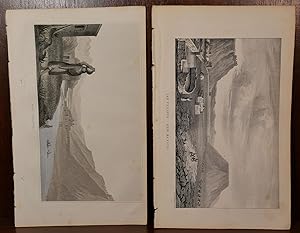
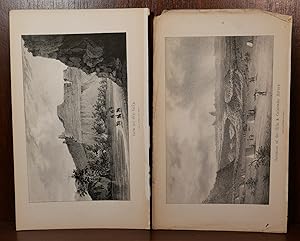
2 lithographs of Gila & Colorado rivers from 1848. Titled "Junction of the Gila & Colorado Rivers", & "View on the Gila". Measuring approximately 8.75" x 5.5" on two plates. These lithographs are in good condition. Minor chipping around edges from binding. Moderate foxing to both plates. Please view the many other rare titles available for purchase at our store. We are always interested in purchasing individual or collections of fine books. Inventory #(O2-42).
-
2 lithographs of Gila & Colorado rivers from 1848. Titled "Junction of the Gila & Colorado Rivers", & "View on the Gila". Measuring approximately 8.75" x 5.5" on two plates. These lithographs are in good condition. Minor chipping around edges from binding. Moderate staining on one of the plates edges. The other is bright and clean. Please view the many other rare titles available for purchase at our store. We are always interested in purchasing individual or collections of fine books. Inventory #(O2-41).
-
Notes of a Military Reconnoissance, from Fort Leavenworth, In Missouri, to San Diego, In California, Including Parts of the Arkansas, Del Norte, and Gila Rivers
Published by Wendell and Van Benthuysen, Printers, Washington DC, 1848
Seller: Tschanz Rare Books, Salt Lake City, UT, U.S.A.
Association Member: ABAA ILAB RMABA
Seller rating 5 out of 5 stars

First Edition
416pp. Octavo [23 cm] Rebound in full brown leather with the title gilt stamped on the backstrip. New marbled endsheets and pastedowns. 42 of 43 plates (lacks 'Chain of Natural Spires on the Gila). Large map not present. This is among the most important government reports on overland travel, with accounts of the march of the Army of the West from Missouri to Santa Fe, and the Mexican-American War in New Mexico and California. Emory went on to explore the overland route to California via southern Arizona, and took part in the American conquest of southern California. The text is illustrated with some of the first American views of the far Southwest. Cowan I p.77. Cowan II p. 195. Eberstadt 114:911. Graff 1249. Howes E145. Reese, Best of the West 103. Rittenhouse 188. Wagner/Camp 148:2. Zamorano 33. Senate Issue, 30th Congress, 1st Session. Executive, No. 7.
-
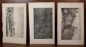
2 cactus lithographs in New Mexico/Arizona. Titles "Cerus Giganteus" & "Vegetation on The Gila" Measuring approximately 8.75" x 5.5" on two plates. These plates are in good condition. Minor chipping to edges that were inside binding. Moderate foxing to both plates. Please view the many other rare titles available for purchase at our store. We are always interested in purchasing individual or collections of fine books. Inventory #(O2-45).
-
Notes of a Military Reconnoissance, from Fort Leavenworth, in Missouri, to San Diego, in California, Including Parts of the Arkansas, Del Norte, and Gila Rivers. (30th Congress, 1st Session. Senate. Executive, No. 7)
Published by Wendell and Van Benthuysen, Printers, Washington, D.C., 1848
Seller: Ken Sanders Rare Books, ABAA, Salt Lake City, UT, U.S.A.
Association Member: ABAA ILAB IOBA RMABA
Seller rating 5 out of 5 stars
Hardcover. Condition: Good +. Second Senate Issue. 416pp. Octavo [22.5 cm] Brown cloth over boards with a paper title label on the spine. Lacking the folding map. Ex-Historical Society copy, with a label on the front pastedown, and a couple of discreet stamps on the title page. Occasional cracks to the text block, but still very sturdy. With 43 plates, including 3 sketch maps. Howes E145. Wagner-Camp 148:2. Flake 3164. Emory's classic report describing terrain and rivers, cities and forts, pueblos and prehistoric ruins, plant and animal life, and Indians and Mexicans, primarily in New Mexico, Arizona, and Southern California, with some mention of the Mormon Battalion.