Young Mitchell Augustus (61 results)

- Softcover
Seller: GreatBookPrices, Columbia, MD, U.S.A.GreatBookPrices
Contact seller5-star sellerCondition: New
US$ 15.27
US$ 2.64 shippingShips within U.S.A.Quantity: Over 20 available
Condition: New.
- Softcover
Seller: GreatBookPrices, Columbia, MD, U.S.A.GreatBookPrices
Contact seller5-star sellerCondition: Used - As new
US$ 15.77
US$ 2.64 shippingShips within U.S.A.Quantity: Over 20 available
Condition: As New. Unread book in perfect condition.
- Softcover
Seller: California Books, Miami, FL, U.S.A.California Books
Contact seller4-star sellerCondition: New
US$ 19.00
Free ShippingShips within U.S.A.Quantity: Over 20 available
Condition: New.

- Softcover
Seller: Rarewaves.com USA, London, LONDO, United KingdomRarewaves.com USA
Contact seller5-star sellerCondition: New
US$ 19.14
Free ShippingShips from United Kingdom to U.S.A.Quantity: Over 20 available
Paperback. Condition: New.
- Softcover
Seller: Ria Christie Collections, Uxbridge, United KingdomRia Christie Collections
Contact seller5-star sellerCondition: New
US$ 18.08
US$ 16.07 shippingShips from United Kingdom to U.S.A.Quantity: Over 20 available
Condition: New. In.
- Softcover
Seller: GreatBookPricesUK, Woodford Green, United KingdomGreatBookPricesUK
Contact seller5-star sellerCondition: New
US$ 17.49
US$ 20.12 shippingShips from United Kingdom to U.S.A.Quantity: Over 20 available
Condition: New.
- Softcover
Seller: GreatBookPricesUK, Woodford Green, United KingdomGreatBookPricesUK
Contact seller5-star sellerCondition: Used - As new
US$ 20.83
US$ 20.12 shippingShips from United Kingdom to U.S.A.Quantity: Over 20 available
Condition: As New. Unread book in perfect condition.

- Hardcover
Seller: Ria Christie Collections, Uxbridge, United KingdomRia Christie Collections
Contact seller5-star sellerCondition: New
US$ 32.95
US$ 16.07 shippingShips from United Kingdom to U.S.A.Quantity: Over 20 available
Condition: New. In.

- Softcover
Seller: moluna, Greven, , Germanymoluna
Contact seller5-star sellerCondition: New
US$ 26.36
US$ 56.71 shippingShips from Germany to U.S.A.Quantity: Over 20 available
Condition: New.

- Hardcover
Seller: moluna, Greven, , Germanymoluna
Contact seller5-star sellerCondition: New
US$ 42.83
US$ 56.71 shippingShips from Germany to U.S.A.Quantity: Over 20 available
Gebunden. Condition: New.

- Softcover
Seller: Rarewaves.com UK, London, United KingdomRarewaves.com UK
Contact seller5-star sellerCondition: New
US$ 17.48
US$ 87.19 shippingShips from United Kingdom to U.S.A.Quantity: Over 20 available
Paperback. Condition: New.
- Softcover
- Print on Demand
Seller: Majestic Books, Hounslow, , United KingdomMajestic Books
Contact seller4-star sellerCondition: New
US$ 21.58
US$ 8.72 shippingShips from United Kingdom to U.S.A.Quantity: 4 available
Condition: New. Print on Demand.

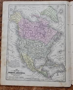
Published by S. Augustus Mitchell, Philadelphia 1858
- Map
Seller: mediumraremaps.com, Franklin, TN, U.S.A.mediumraremaps.com
Contact seller5-star seller10 3/4 x 8 3/8 inches. Colored map of the two states encompassing Lakes Michigan, Superior and Huron. Each state has the then extent of county subdivision illustrated. Rail networks are evident. Overall a nice small scale presentation of the two states. Very good with carefully stenciled full was color. J. H. Young (illustrator)….
- Softcover
- Print on Demand
Seller: Books Puddle, New York, NY, U.S.A.Books Puddle
Contact seller4-star sellerCondition: New
US$ 27.48
US$ 3.99 shippingShips within U.S.A.Quantity: 4 available
Condition: New. Print on Demand.
- Softcover
- Print on Demand
Seller: Biblios, frankfurt am main, HESSE, GermanyBiblios
Contact seller4-star sellerCondition: New
US$ 23.95
US$ 11.52 shippingShips from Germany to U.S.A.Quantity: 4 available
Condition: New. PRINT ON DEMAND.
- Hardcover
- Print on Demand
Seller: PBShop.store US, Wood Dale, IL, U.S.A.PBShop.store US
Contact seller5-star sellerCondition: New
US$ 35.48
Free ShippingShips within U.S.A.Quantity: Over 20 available
HRD. Condition: New. New Book. Shipped from UK. THIS BOOK IS PRINTED ON DEMAND. Established seller since 2000.
- Hardcover
- Print on Demand
Seller: PBShop.store UK, Fairford, GLOS, United KingdomPBShop.store UK
Contact seller5-star sellerCondition: New
US$ 35.04
US$ 4.41 shippingShips from United Kingdom to U.S.A.Quantity: Over 20 available
HRD. Condition: New. New Book. Delivered from our UK warehouse in 4 to 14 business days. THIS BOOK IS PRINTED ON DEMAND. Established seller since 2000.
 More images
Published by Augustus Mitchell, Philadelphia 1839
- Map
Seller: DogStar Books, Lancaster, PA, U.S.A.DogStar Books
Contact seller5-star sellerCondition: Used - Very good
US$ 85.00
US$ 6.15 shippingShips within U.S.A.Quantity: 1 available
Map. Condition: Very Good-. Hand colored map; 4to 11" - 13" tall; 1 pages; Circa 1848, copyrighted 1839. Augustus Mitchell. Single 4to leaf map 10.50 H x 8 W Inches. Hand colored. Shows Texas borders extending to Santa Fe in "stovepipe" configuration but not as a Republic. Cities accompanied by population estmates. Alaska shown…as "Russian America" and Canada as "British America" and "New Britain." Explanation of symbols included. Light toning and soiling to edges of margins. Bright generally neat example. VG-.
- Hardcover
- Print on Demand
Seller: Majestic Books, Hounslow, , United KingdomMajestic Books
Contact seller4-star sellerCondition: New
US$ 35.55
US$ 8.72 shippingShips from United Kingdom to U.S.A.Quantity: 4 available
Condition: New. Print on Demand.
 More images
Published by Samuel Augustus Mitchell, Philadelphia 1834
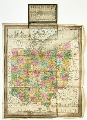
- Hardcover
- First Edition
Seller: Riverrun Books & Manuscripts, ABAA, Ardsley, NY, U.S.A.Riverrun Books & Manuscripts, ABAA
Contact seller5-star sellerEarly issue (the first was 1831). Hand-colored engraved folding map, 15 3/4 x 13 1/4 inches. Folding to 5 x 3 inches into original green gilt-decorated roan binding. Provenance: William Fitch (contemporary ownership signatures on verso of map). Mounted on the inside front cover of the binding is the 1830 Census data for the stat…e, recording the total population of the state at 937,903. At bottom of the map are Profiles of the Ohio and Erie Canal, and the Miami Canal. 73 counties are delineated, the most populated then being Hamilton, Columbiana, and Muskingum. Light rubbing to binding, a few short separations along folds, light wear at sheet edges.

Published by S. Augustus Mitchell, Philadelphia 1831
- Hardcover
Seller: Jeffrey H. Marks, Rare Books, ABAA, Rochester, NY, U.S.A.Jeffrey H. Marks, Rare Books, ABAA
Contact seller5-star sellerEngraved tinted map. Image size approx. 17 x 21 inches, folded into 16mo gilt-lettered leather boards as issued. Fine.
 More images
Published by Published by S. Augustus Mitchell, Philadelphia 1833
- Hardcover
- First Edition
Seller: Tavistock Books, ABAA, Reno, NV, U.S.A.Tavistock Books, ABAA
Contact seller5-star seller1st edition [presumed]. Text insets: Steam Boat Routes [left side]; Population of . Indiana . 1830 [right side]. "Entered according to Act of Congress, in the year 1833." -- Lower left margin. Hand-colored, fold-out 18-panel lithographic map. Prime meridians: Greenwich, Washington. Engraved by J.H. Young & F. Dankworth. Case: 4-…7/8" x 2-7/8". Map [unfolded]: 15-3/4" x 13-3/16" Indiana was admitted to the Union on December 11, 1816, as the 19th state. The first published map of the state was created by John Melish and published in 1817. This Mitchell product here offered was the first of many Tourist's Pocket Map editions to published by Mitchell, only 16 year after that by Melish. This map shows early 19th C Indiana roads, existing & proposed canals, existing & proposed railroads, counties, township grid, cities, towns, marshland, and notable physical features. It includes distances and tables of steamboat routes and county populations. As such, this map documents the infastructure ambitions & projects undertaken by the relatively new Indiana state government. Despite the noble aims of their efforts, profligate spending ultimately ruined the state's credit. By 1841, the state was near bankruptcy and was forced to liquidate most of its public works. [Wiki / IHS]. OCLC records 9 institutional holdings, though curiously enough, apparently not at the Lilly. RBH shows 2009 as the last market appearance of this 1833 edition. Modest extremity wear & rubes to case, VG - VG+. Map detached from case, general extremity wear, age-toning, the occasional split along a fold, some with accompaning japanese paper repair. A Good only copy of this uncommon piece of Indiana history. Gilt-stamped black leather pocket case. Cover title: "Mitchell's Map of Indiana." Inside front cover affixed a text panel, "Public Lands", which explains the sale process of same.
Published by S. Augustus Mitchell, Philadelphia 1832
- Hardcover
Seller: Jeffrey H. Marks, Rare Books, ABAA, Rochester, NY, U.S.A.Jeffrey H. Marks, Rare Books, ABAA
Contact seller5-star sellerCounties and boarders in color. Image approx. 17 x 21 inches, folded into 16mo leather gilt-lettered portfolio as issued. A fine, unrestored copy with a few tiny breaks at corner folds and the slightest of rubbing to the edges of the leather. With an inset "Plan of Washington City.".
 More images
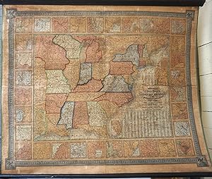
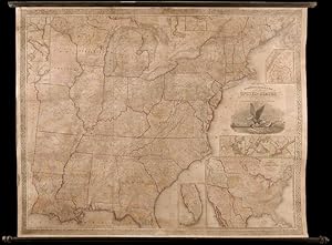
Published by August Mitchell, Philadelphia 1843
- Hardcover
- First Edition
Seller: Antipodean Books, Maps & Prints, ABAA, Garrison, NY, U.S.A.Antipodean Books, Maps & Prints, ABAA
Contact seller3-star sellerFirst edition. A rare wall map published by Mitchell, with only one copy cited at the Clements Library (OCLC: 9123797110.) The map was published in 1843 in a different folded format, with three sheets and bound in a gilt leather folder. In this presentation, the large scale map of the eastern United States is surrounded with ins…ets of major harbors and towns. The large Iowa Territory and Minnesota are not yet named. The map shows the country west to the Indian Territory west of Missouri, including the eastern part of Texas, north including most of Maine with a touch of Canada, and south through most of Florida. In the lower right, are tables "Population of Each County & c., in the Different States and Territories of the United States in 1840". The whole is bordered with an elaborate design. The inset of Maine is captioned "Map of the North-eastern Boundary of the United States according to the Treaty of 1842." From the "National Map Series that Mitchell produced by subscription over many years. Drawn by James H. Young and engraved by J. H. Brightly, published by S. Augustus Mitchell, Philadelphia, 8 1/2 South - 1843 - 7th St. With the original rollers. Original color but varnished as usual. Archivally repaired, backed on linen, supporting many cracks with no loss. Printed area 45 x 39" (114 x 96.5 cm) on paper 48 x 40" (122 x 101 cm). Map of the southern part of Florida; Inset title:; Map of the north-eastern boundary of the United States according to the treaty of 1842; Inset title:; Vicinity of Burlington, Vermont; Inset title:; Vicinity of Portland, Maine; Inset title:; Vicinity of Portsmouth, New Hampshire; Inset title:; Vicinity of Boston, Massachusetts; Inset title:; Vicinity of Lowell, Massachusetts; Inset title:; Vicinity of Providence, Rhode Island; Inset title:; Vicinity of Hartford, Connecticut; Inset title:; Vicinity of New Haven, Connecticut; Inset title:; Vicinity of Albany, New York; Inset title:; Vicinity of Savannah, Georgia; Inset title:; Vicinity of Natchez, Mississippi; Inset title:; Vicinity of New York, New York; Inset title:; Vicinity of Pittsburg, Pennsylvania; Inset title:; Vicinity of Nashville, Tennessee; Inset title:; Vicinity of Mobile, Alabama; Inset title:; Vicinity of Trenton, New Jersey; Inset title:; Vicinity of Rochester, New York; Inset title:; Vicinity of Raleigh, North Carolina; Inset title:; Vicinity of New Orleans, Louisiana; Inset title:; Vicinity of Philadelphia, Pennsylvania; Inset title:; Vicinity of Buffalo, New York; Inset title:; Vicinity of Charleston, South Carolina; Inset title:; Vicinity of Richmond, Virginia; Inset title:; Vicinity of Baltimore, Maryland; Inset title:; Vicinity of Detroit, Michigan; Inset title:; Vicinity of Cincinnati, Ohio; Inset title:; Vicinity of Indianapolis, Indiana; Inset title:; Vicinity of Springfield, Illinois; Inset title:; Vicinity of St. Louis, Missouri; Inset title:; Vicinity of Frankfort, Kentucky; Inset title:; Vicinity of Louisville, Kentucky; Inset title:; Vicinity of Washington, District of Columbia.
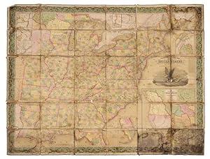
Mitchell's Reference & Distance map of the United States.
MITCHELL, Samuel Augustus (1790-1868) and James H. Young (1817-1866)
Published by Philadelphia: Samuel Augustus Mitchell, 1848 (copyright 1833) 1848
- Softcover
- First Edition
Seller: Arader Galleries - AraderNYC, New York, NY, U.S.A.Arader Galleries - AraderNYC
Contact seller5-star sellerUnbound. 1st Edition. "Engraved folding wall map with large inset map of Texas, Oregon and California in lower right, several smaller inset maps of the Falls of Niagara, Northern Maine, Rochester, Albany, Washington, Charleston, and Florida on the perimeter (overall 56 x 71 in.; 142.5 x 179.6 cm), hand-colored in wash and outlin…e, dissected in 36 sections and mounted on linen, engraving of an eagle on a seashell grasping an olive branch in his left talon and arrows in the right, flanked by the capitol at Washington and Philadelphia (attributed to William Mason), wide ornate vine border, green cloth selvage. BINDING/CONDITION: Marbled paper outer panels. Dampstained with traces of mold chiefly on the linen backing but occasionally affecting portions of the map, some sections separating from backing at corners, margins of several sections creased. (65B2C) FIRST PRINTING OF A LANDMARK MAP OF THE WEST AND THE FIRST TO INCLUDE AN INSET MAP OF TEXAS. This monumental wall map was produced by Mitchell the same year as his pocket size map of Texas, Oregon and California "[It is] an important map [depicting] the western political situation on the eve of the Mexican War. A composite map, it judiciously incorporated the recent work of Nicollet, Wilkes, Frémont, and Emory. Both the Oregon Trail and the 'Caravan route to Santa Fe' are included" (Schwartz & Ehrenberg). Wheat adds: "This map represents a great step forward [utilizing] the recent explorations that had bounded and determined the nature of the Great Basin. The Texas claim to a western boundary up to the Rio Grande is here shown, with the northern panhandle extending all the way to the 42nd parallel, following Emory's map of Texas" (Wheat). PROVENANCE: Evelyn and Eric P. Newman (sale, Leslie Hindman, 12 November 2018, Lot 89) REFERENCES: Rumsey 4308.000; Schwartz & Eherenberg, The Mapping of America, p. 276; Wheat, Mapping of the Transmississippi (1959) II:35, no. 520 (referring to the pocket map's "Accompaniement")".
 More images
Mitchell's Reference and Distance Map of the United States
MITCHELL, S. Augustus (1792-1868), and James H. YOUNG (fl.1817-50)
Published by S. Augustus Mitchell, Philadelphia 1845
- Hardcover
- Map
Seller: Donald A. Heald Rare Books (ABAA), New York, NY, U.S.A.Donald A. Heald Rare Books (ABAA)
Contact seller5-star sellerCopper-engraved wall map, with full original colour, expertly repaired, backed with modern linen, trimmed in green cloth, on contemporary rollers, with bright colour, overall in very good condition. An impressive wall map of the United States from a crucial year in American history. In 1834 Mitchell republished his A New Map of…the United States under the title of Reference and Distance Map. New, updated editions appeared almost yearly. When compared to the 1833 edition of the former, this 1845 edition of the Reference and Distance Map shows many new developments in the upper Midwest. The outline of Lake Michigan has undergone extensive corrections. An oversized Wisconsin Territory (1836) now appears. Two of the small insets of American towns have been removed from the upper left-hand corner so that the new oversized Territory of Iowa (1838) could be added. The large inset General Map of the United States now shows Texas in its last year as an independent Republic. An important American map, showing the country on the eve of its second great national expansion. Rumsey 4223; Phillips, Maps, p. 898.
Mitchell's Traveller's Guide through the United States, Containing the Principal Cities, Towns, &c Alphabetically Arranged; Together with the Stage, Steam-Boat, Canal, and Rail-Road Routes, with the Distances, in Miles, from Place to Place.
MITCHELL, Samuel Augustus (1792-1868) and YOUNG, James Hamilton
Published by Philadelphia: Thomas, Cowperthwait & Co., [1845]. 1845
- Hardcover
Seller: Arader Galleries - AraderNYC, New York, NY, U.S.A.Arader Galleries - AraderNYC
Contact seller5-star sellerHardcover. Folding engraved map (17 4/8 x 21 4/8 inches) showing the United States as far west as Indiana Territory, as far south as Florida with 8 insets of the Vicinity of Cincinnati; Vicinity of Albany; Vicinity of the Falls of Niagara; Vicinity of New York; Vicinity of Charleston; Vicinity of Baltimore and Washington; Vicini…ty of Philadelphia; and Vicinity of Boston, with original hand-colour in outline (very browned). 78-page guide. Original blind-embossed tan roan, lettered in gilt on upper cover. Provenance: Several canal routes through Ohio, Indiana, Pennsylvania, and New York shown in blue ink. First published in 1832, with accompanying text added in 1834, and continuously updated and enlarged. "Internal improvements coupled with the great Irish and German migrations beginning in 1827 led to the production of traveler's guides that depicted roads and their distances, steamboat and canal routes, and lengths of principal railroads. In 1832 Samuel Augustus Mitchell first issued his 'Traveller's Guide through the United States' and complimented it two years later with 'Tourist Pocket Maps' of the different states. These early works and their multitudinous progeny over the next fifty years laid the foundation for the road maps of today" (Schwartz & Ehrenberg, The Mapping of America, page 255).
Map of the States of Ohio, Indiana and Illinois with the Settled Part of Michigan.
MITCHELL, Samuel Augustus (1792-1868) and YOUNG, James Hamilton
Published by Philadelphia: S. Augustus Mitchell, 1835. 1835
- Hardcover
Seller: Arader Galleries - AraderNYC, New York, NY, U.S.A.Arader Galleries - AraderNYC
Contact seller5-star sellerHardcover. Engraved folding pocket map (17 4/8 x 21 6/8 inches to the neat-line, full margins). Letterpress census laid down on the front past-down. Fine folding engraved map with insets of the "Lead Region East of the Mississippi River"; "Falls of Ohio"; "Vicinity of Cincinnati"; and "Vicinity of Detroit", with original hand-co…lour in full (some browing and short separations at folds). Contemporary publisher's red roan, gilt (scuffed). First issued in 1834, and with some changes from that issue: Lake Michigan has been redrawn, the addition of new counties in Indiana is notes, such as Porter, Newton, and Jasper, etc.). Iowa did not become a territory until 1838 and a state until 1844, and is labeled here as Missouri and Wisconsin Territory. Interestingly this map shows the controversial Dubuque lead mining region, including the site of Julien Dubuque's grave. Between 1796, when this grant was confirmed by the Spanish governor of Louisiana, and his death in 1810, Dubuque had succeeded in establishing a monopoly controlling the smelting and shipping of lead from the region, known as the "Mines of Spain". Unable to sustain a working relationship with the local Ioway Indians Dubuque's creditors who succeeded to his rights abandoned the enterprise, and lead-mining rights in Iowa remained in a legal turmoil that lasted until 1853, when the United States Supreme Court issued a landmark decision on the ownership of the Dubuque area mines, disallowing claims based on Julien Dubuque's Spanish land grants.
Map of the States of Ohio, Indiana and Illinois with the Settled Part of Michigan.
MITCHELL, Samuel Augustus (1792-1868) and YOUNG, James Hamilton
Published by Philadelphia: S. Augustus Mitchell, 1836. 1836
- Hardcover
Seller: Arader Galleries - AraderNYC, New York, NY, U.S.A.Arader Galleries - AraderNYC
Contact seller5-star sellerHardcover. Engraved folding pocket map (17 4/8 x 22 2/8 inches to the neat-line, full margins). Letterpress census laid down on the front past-down. Fine folding engraved map with insets of the "Lead Region East of the Mississippi River"; "Falls of Ohio"; "Vicinity of Cincinnati"; and "Vicinity of Detroit", with original hand-co…lour in full (some spotting and offseting). Contemporary publisher's cherry roan, gilt (a bit rubbed). First issued in 1834, and with some changes from that issue: Lake Michigan has been redrawn, the addition of new counties in Indiana is notes, such as Porter, Newton, and Jasper, etc.). Iowa did not become a territory until 1838 and a state until 1844, and is labeled here as Missouri and Wisconsin Territory. Interestingly this map shows the controversial Dubuque lead mining region, including the site of Julien Dubuque's grave. Between 1796, when this grant was confirmed by the Spanish governor of Louisiana, and his death in 1810, Dubuque had succeeded in establishing a monopoly controlling the smelting and shipping of lead from the region, known as the "Mines of Spain". Unable to sustain a working relationship with the local Ioway Indians Dubuque's creditors who succeeded to his rights abandoned the enterprise, and lead-mining rights in Iowa remained in a legal turmoil that lasted until 1853, when the United States Supreme Court issued a landmark decision on the ownership of the Dubuque area mines, disallowing claims based on Julien Dubuque's Spanish land grants.
Map of the States of Ohio, Indiana and Illinois with the Settled Part of Michigan.
MITCHELL, Samuel Augustus (1792-1868) and YOUNG, James Hamilton.
Published by Philadelphia: S. Augustus Mitchell, 1837. 1837
- Hardcover
Seller: Arader Galleries - AraderNYC, New York, NY, U.S.A.Arader Galleries - AraderNYC
Contact seller5-star sellerHardcover. Single sheet (17 x 21 inches to the neat-line, full margins). Letterpress census laid down on the front past-down. Fine folding engraved map with insets of the "Lead Region East of the Mississippi River"; "Falls of Ohio"; "Vicinity of Cincinnati"; and "Vicinity of Detroit", with original hand-colour in full (laid down… on archival tissue, one or two small losses, some staining). Original black roan, gilt (a bit rubbed). Provenance: some canal routes marked in red and blue pen. First issued in 1834, and with some changes from that issue: Lake Michigan has been redrawn, the addition of new counties in Indiana is notes, such as Porter, Newton, and Jasper, etc.). Iowa did not become a territory until 1838 and a state until 1844, and is labeled here as Missouri and Wisconsin Territory. Interestingly this map shows the controversial Dubuque lead mining region, including the site of Julien Dubuque's grave. Between 1796, when this grant was confirmed by the Spanish governor of Louisiana, and his death in 1810, Dubuque had succeeded in establishing a monopoly controlling the smelting and shipping of lead from the region, known as the "Mines of Spain". Unable to sustain a working relationship with the local Ioway Indians Dubuque's creditors who succeeded to his rights abandoned the enterprise, and lead-mining rights in Iowa remained in a legal turmoil that lasted until 1853, when the United States Supreme Court issued a landmark decision on the ownership of the Dubuque area mines, disallowing claims based on Julien Dubuque's Spanish land grants.


