
Order Total (1 Item Items):
Shipping Destination:

map collector publications ltd tring hertfordshire (8 results)
Skip to main search results
Product Type
- All Product Types
- Books (8)
- Magazines & Periodicals
- Comics
- Sheet Music
- Art, Prints & Posters
- Photographs
- Maps
- Manuscripts & Paper Collectibles
Condition
Binding
Collectible Attributes
Free Shipping
- Free US Shipping
Seller Location
Seller Rating
-

London Map-Sellers 1660-1720
Published by Map Collector Publications Limited, Tring,Hertfordshire, 1978
Seller: Old New York Book Shop, ABAA, Atlanta, GA, U.S.A.
Seller Rating:

First Edition
Hardcover. Condition: Very Good. First Edition. Octavo. 150pp + index. A very good copy in green cloth without dj.
-
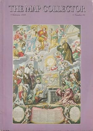
THE MAP COLLECTOR. No. 64
Published by The Map Collector Publications Ltd. Tring, Hertfordshire. ., 1993
Seller: Jean-Louis Boglio Maritime Books, CYGNET, TAS, Australia
Association Member: ANZAAB ILAB
Seller Rating:
No. 64, Autumn 1993. 72 PP with b/w and colour illustrations, and advertisements. Pictorial soft cover. Fine. 29.7 x 21. Six new world maps, by Rodney Shirley. The mapping of Everest, by Michael Ward. George Louis Le Rouge, Vitus Bering, and Admiral de Fonte, by Warren Heckrotte and Edward H. Dahl. The map of the Holy Land, by Elizabeth M. Ingram. John Rudd, a forgotten Tudor mapmaker, by David Marcombe.
-

London Map-Sellers: 1660-1720
Published by Map Collector Publications Ltd., Tring, Hertfordshire, 1978
ISBN 10: 0906430003ISBN 13: 9780906430002
Book First Edition Signed
Hardcover. Condition: Very Good. No Jacket. First Edition. The book is in very good condition. The binding is tight and the tet is clean, it's remarkably unaged for 1978. Gift inscription by the author inside. Size: 8vo - over 7�" - 9�" tall. By Author.
-
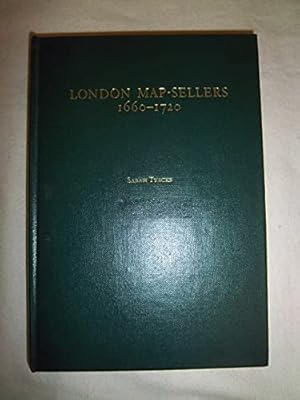
London Map-sellers, 1660-1720
Published by Tring (Hertfordshire), Map Collector Publications Ltd 01.11.1978., 1978
ISBN 10: 0906430003ISBN 13: 9780906430002
Book
8�, Gebundene Ausgabe. Condition: Sehr gut. 159 Seiten Sehr gutes und sauberes Exemplar. Sprache: Englisch Gewicht in Gramm: 538.
-

TOOLEY'S DICTIONARY OF MAPMAKERS - Revised Edition E - J
Published by Map Collector Publications Limited & Richard Arkway, Inc. Tring, Hertfordshire, UK. ., 2001
ISBN 10: 0906430194ISBN 13: 9780906430194
Seller: Jean-Louis Boglio Maritime Books, CYGNET, TAS, Australia
Association Member: ANZAAB ILAB
Seller Rating:
Book
Revised edition. VI, 462 PP with b/w illustrations: headpieces, tailpieces, signatures, title page of Atlas, portraits of mapmakers (including around 43 plates on full page). Fp: Travels of Abraham Ortelius and Joris Hoefnagel. Marbled endpapers. Cloth covers, gilt title on front board and spine, dj. Faint foxing spots on top outside edge, o/wise a fine copy. 25.7 x 17.8.
-
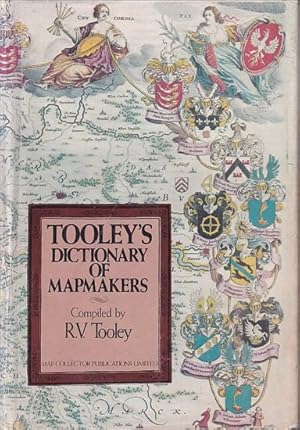
TOOLEY'S DICTIONARY OF MAPMAKERS
Published by Map Collector Publications Limited. Tring, Hertfordshire, UK. ., 1979
ISBN 10: 0906430054ISBN 13: 9780906430057
Seller: Jean-Louis Boglio Maritime Books, CYGNET, TAS, Australia
Association Member: ANZAAB ILAB
Seller Rating:
Book First Edition
1st Ed. Preface by Helen Wallis. XII, 684 PP with b/w illustrations: signatures, manuscript page, title page of Atlas, portraits of mapmakers (including 58 plates on full page). Eps: Portraits of Mercator and Hondus. Cloth covers, gilt title on front board and spine, dj. Dust jacket chipped, lightly sunned and now protected. Foxing spots on outside edges, o/wise a near fine copy. Scarce. 26 x 18.5.
-

TOOLEY'S DICTIONARY OF MAPMAKERS - Revised Edition A - D
Published by Map Collector Publications Limited & Richard Arkway, Inc. Tring, Hertfordshire, UK. ., 1999
ISBN 10: 0906430143ISBN 13: 9780906430149
Seller: Jean-Louis Boglio Maritime Books, CYGNET, TAS, Australia
Association Member: ANZAAB ILAB
Seller Rating:
Book
Revised edition. Preface by C. Broekema. Foreword by, Francis Herbert. XIV, 408 PP with b/w illustrations: signatures, title page of Atlas, portraits of mapmakers (including around 36 plates on full page). Fp: Terrarum Tractus, . Marbled endpapers. Cloth covers, gilt title on front board and spine, dj. Errata slip inserted page 274. Ex-libris of previous owner on inside front cover, faint foxing spots on top outside edge, o/wise a fine copy. 25.7 x 17.8.
-
Printed Maps of the British Isles, 1650-1750
Published by Map Collector Publications Ltd.,, Tring, Hertfordshire, 1988
Seller: Daniel Crouch Rare Books Ltd, London, United Kingdom
Association Member: ABA ILAB PBFA
Seller Rating:

Book
Shirley's cartobibliography of the British Isles Hardcover, 168 pages. A bibliographical study of over 280 general maps of the British Isles printed between 1650-1760, including antecedents, makers and engravers, topographical and decorative features, and successor states of each map.

