
Order Total (1 Item Items):
Shipping Destination:

America by Map, Signed (9 results)
Skip to main search results
Search filters
Product Type
- All Product Types
- Books (5)
- Magazines & Periodicals (No further results match this refinement)
- Comics (No further results match this refinement)
- Sheet Music (No further results match this refinement)
- Art, Prints & Posters (No further results match this refinement)
- Photographs (No further results match this refinement)
- Maps (4)
- Manuscripts & Paper Collectibles (No further results match this refinement)
Condition Learn more
- New (No further results match this refinement)
- As New, Fine or Near Fine (2)
- Very Good or Good (2)
- Fair or Poor (No further results match this refinement)
- As Described (5)
Binding
Collectible Attributes
Language (2)
Free Shipping
- Free Shipping to U.S.A. (No further results match this refinement)
Seller Location
Seller Rating
-

Jeff Shaara's Civil War Battlefields: Discovering America's Hallowed Ground
Language: English
Published by Ballantine Books, U. S. A., 2011
ISBN 10: 0345464885 ISBN 13: 9780345464880
Signed
Trade Paperback. Condition: Near Fine. Illustrated B&W Photos & Map(s) (illustrator). There is a bookplate attached to the Fep that is flat signed by Shaara. Signed by Author(s).
-

How the West Was Lost: Theft and Usurpation of State's Property Rights; America's Frontier: 1776-2000, Our Public Land- Who Really Owns It
Language: English
Published by Council Press / Cedar Fort, Incorporated / Bonneville Press, Springville, 2000
ISBN 10: 1555174868 ISBN 13: 9781555174866
Seller: Arroyo Seco Books, Pasadena, Member IOBA, Pasadena, CA, U.S.A.
Association Member: IOBA
Seller rating 4 out of 5 stars

First Edition Signed
Boards. Condition: Fine. Dust Jacket Condition: Fine Dustjacket. Folding Color Map (illustrator). First Edition. 446 pp. #162 of 500 signed, numbered copies. Additionally inscribed on front endpaper. Signed personal letter from author and a copy of a letter to the author are both laid in loosely. Inscribed by Author(s).
-

A Path Out of the Desert; A Grand Strategy for America in the Middle East
Language: English
Published by Random House, New York, 2008
ISBN 10: 1400065488 ISBN 13: 9781400065486
Seller: Ground Zero Books, Ltd., Silver Spring, MD, U.S.A.
Seller rating 5 out of 5 stars

First Edition Signed
Hardcover. Condition: Very good. Dust Jacket Condition: Very good. Anita Karl and Jim Kemp (Map) and Day Walters (Aut (illustrator). [2], xlviii, 539, [5] pages. Minor edge soiling. Foreword by Strobe Talbot. Notes. Index. Minor sticker residue on DJ back. Lengthy inscription from the author on the fep that reads: "11/25/08 For Frank, My two decades in Washington have been filled with disappointments about the people I've met. It is why I have so enjoyed getting to know you. Your intelligence, perspicacity, insight and abilities stand out far above the mediocrity of this town. Your are the kind of person that I and every American hopes and dreams of for our Nation's Capital--Truly one of our best and brightest. Please accept this as a token of my affection and admiration. Fondly, Ken." "Kenneth Michael Pollack (born 1966) is an American former CIA intelligence analyst and expert on Middle East politics and military affairs. He has served on the National Security Council staff and has written several articles and books on international relations. Currently, he is a resident scholar at the American Enterprise Institute, "where he works on Middle Eastern political-military affairs, focusing in particular on Iran, Iraq, Saudi Arabia, and the Gulf countries. Before that he was Senior Fellow at the Saban Center for Middle East Policy at the Brookings Institution and a senior advisor at Albright Stonebridge Group, a global business strategy firm." The greatest danger to America's peace and prosperity, notes leading Middle East policy analyst Kenneth M. Pollack, lies in the political repression, economic stagnation, and cultural conflict running rampant in Arab and Muslim nations. By inflaming political unrest and empowering terrorists, these forces pose a direct threat to America's economy and national security. The impulse for America might be to turn its back on the Middle East in frustration over the George W. Bush administration's mishandling of the Iraq War and other engagements with Arab and Muslim countries. But such a move, Pollack asserts, will only exacerbate problems. He counters with the idea that we must continue to make the Middle East a priority in our policy, but in a humbler, more humane, more realistic, and more cohesive way. Pollack argues that Washington's greatest sin in its relations with the Middle East has been its persistent unwillingness to make the sustained and patient effort needed to help the people of the Middle East overcome the crippling societal problems facing their governments and societies. As a result, the United States has never had a workable comprehensive policy in the region, just a skein of half-measures intended either to avoid entanglement or to contain the influence of the Soviet Union. Beyond identifying the stagnation of civic life in Arab and Muslim states and the cumulative effect of our misguided policies, Pollack offers a long-term strategy to ameliorate the political, economic, and social problems that underlie the region's many crises. Through his suggested policies, America can engage directly with the governments of the Middle East and indirectly with its people by means of cultural exchange, commerce, and other soft approaches. He carefully examines each of the region's most contested areas, including Iraq, Iran, Syria, and Lebanon, as well as the Israeli-Palestinian peace process, and explains how the United States can address each through mutually reinforcing policies. At a time when the nation will be facing critical decisions about our continued presence in Iraq and Afghanistan, A Path Out of the Desert is guaranteed to stimulate debate about America's humanitarian, diplomatic, and military involvement in the Middle East. First Edition [stated]. First printing [per Random House convention--printing line starts with '2' and First Edition is present].
-
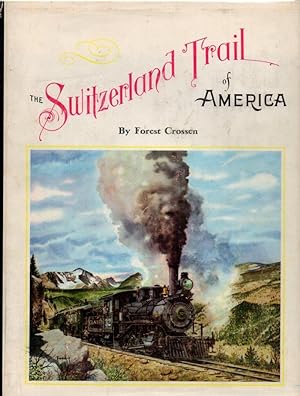
The Switzerland Trail of America: An Illustrated History of the Romantic Narrow Gauge Lines Running West from boulder, Colorado: The Greeley, Salt Lake & Pacific and The Colorado & Northwestern, Later the Denver, Boulder & Western
Published by Pruett Press, Inc, Boulder, CO, 1962
Seller: Clausen Books, RMABA, Colorado Springs, CO, U.S.A.
Association Member: IOBA RMABA
Seller rating 5 out of 5 stars
First Edition Signed
Blue Cloth. Condition: Very Good. Dust Jacket Condition: Very Good (in mylar). Photographs/Colored plates/Rear Pocket Map (illustrator). Limited Edition. Copy #343 of 4000. Author's blue inked signature on limitation page. Scott O'Malley & Associates label on 2nd ffep verso. Charted endpapers. Light seperation to front hinge, yet all pages are secure and intact. Beautifully colored plates and b&w photographs, glossy pages. Navy blue cloth binding, minor wear to head and foot of spine. Unclipped dust jacket, a bit of loss to extremities, light chipping to corners, moderate crease on head of spine/back cover, mylar sleeved. Rear pocket with folded maps; LACKS THE MAP OF THE COMPANY MILL AT CULBERTSON; 417p., including index. Wynar/Depp 6634. Size: 4to - over 9�" - 12" tall. Signed by Author. Hardcover.
-

AMERIQUE DU NORD [A RARE WALL MAP OF NORTH AMERICA]
Published by Paris Andriveau-Goujon 1854, 1854
Seller: Buddenbrooks, Inc., Newburyport, MA, U.S.A.
Association Member: ABAA ILAB SNEAB
Seller rating 5 out of 5 stars
Signed
A rare wall map of North America which appeared in Andriveau-Goujon's Atlas Choix Very handsome with contemporary hand colouring, engraved by Flahaut, Text by Warin. 940mm (H) x 680mm (L); the folded map in case 230mm x 145mm, the map laid on canvas and divided into 21 foldable quadrants with the elegant original marbled slipcase The map in perfect condition, the slipcase with a bit of wear at the corners. VERY SCARCE LARGE WALL MAP OF NORTH AMERICA IN 1854. With an early depiction of the Trans-Mississippi West, including a not yet boundary completed Texas, Ozark District, Mandan District, Osage District and a massive Nebraska Territory as well as an early attempt at defining the Washington and Oregon territories. The map includes the Arctic and Polar regions, Greenland, Mexico, Central America and the Caribbean area. Adolphe Hippolyte Dufour, also known as Auguste-Henri Dufour, lived 1795 - 1865. Based in Paris he was well known in his time, his maps having been published over a number of decades. He worked with many cartographers and engravers of his day and left a rich body of work. His association with Andriveau-Goujon was significant. America in 1854 was undergoing significant political activity regarding the expansion of the country. In January Senator Stephen Douglas introduced a bill to form the Nebraska Territory. The bill sparked major debates related to slavery issues and evolved into the KansasNebraska Act. In March at the Battle of Cieneguilla, The U.S. First Regiment of Dragoons attacked a larger force of Jicarilla Apache and Ute Native Americans near present-day Pilar, New Mexico. The Americans were forced to retreat after losing more than half their number. In May, the KansasNebraska Act wass signed into law, creating Kansas Territory and Nebraska Territory, opening new lands, repealing the Missouri Compromise of 1820, and allowing settlers in those territories to determine if they would allow slavery within their boundaries. In August, at the Grattan massacre, a group of U.S. Army soldiers in Nebraska Territory in present-day Wyoming are killed by Lakota Sioux warriors after they killed Chief Conquering Bear, starting the First Sioux War. In October Abraham Lincoln, in his "Peoria speech", expresses opposition to the KansasNebraska Act, Popular Sovereignty, and the expansion of slavery in the United States. This rare map of the country in 1854 provides context and geography at a most significant time in American history, a time of expansion and of internal debate regarding slavery and the future makeup of the country.
-

Chart Showing the Positions of the Dredgings Deeper than 100 Fathoms Made by the U.S. Fish Commission Steamship Albatross in the North Atlantic Ocean, Caribbean Sea, and around South America from 1883 to 1888.
Publication Date: 1900
Seller: Geographicus Rare Antique Maps, Brooklyn, NY, U.S.A.
Association Member: ABAA ESA ILAB
Seller rating 4 out of 5 stars
Map Signed
Very good. Exhibits light wear along original fold lines. Left side remargined. Size 23.35 x 16.5 Inches. This is a 1900 C. H. Townsend and U.S. Fish Commission map of Atlantic Ocean Caribbean Sea floor samplings deeper than 100 fathoms. Red numbers identify these dredging locations and can be correlated with detailed data in USS Albatross archives. Stretching from Gulf of St. Lawrence south to northern South America including the Greater and Lesser Antilles and the Bahamas, dredgings marked were collected by the Albatross between 1883 and 1888. A large inset along the right border illustrates the entirety of South America and notes dredgings taken by the Albatross off the coast of Brazil and Chile. A smaller inset focuses on the Gulf of Mexico from New Orleans along the U.S. Gulf Coast to the Florida Keys and south to the Yucatan, with dredgings noted in the Gulf south of Mobile and around the Yucatan Peninsula. The USS Albatross This USS Albatross , also known as the USFC Albatross in scientific papers, was the first specifically built marine research vessel. Albatross operated in the Atlantic between December 1882 and November 1887, when she began her voyage to the Pacific Ocean. She arrived at the Straits of Magellan on January 23, 1888, and then continued up the coast of South America, stopping in the Galapagos briefly in April 1888. She operated along the U.S. Pacific coast and as far north as the Bering Sea and as far south as Panama between 1888 and 1898, when she was converted into an auxiliary cruiser for service during the Spanish-American War. After this work was finished, she sailed for Mexico, but did not see combat before peace treaties were signed. She immediately underwent conversion back to being a research vessel. After the retrofit, Albatross left San Francisco on August 23, 1899 and spent the next few months in the Central and South Pacific, before arriving in Yokohama, Japan, on March 4, 1900. Albatross continued her research work until she was transferred to the Navy on May 2, 1917, for service during World War I. She served with the American Patrol Detachment as a gunboat and protected tankers transporting oil and petroleum in the Caribbean and the Gulf of Mexico. After World War I, Albatross returned to research work, until she was decommissioned on October 29, 1921. She was sold to Thomas Butler and Company of Boston in June 1924, without her library, equipment, or instruments. Butler converted her into a school ship, then refitted her as a training ship for 'nautical students and cadets'. She left for Europe with 119 students on board on July 12, 1927. However, the students filtered off the ship at a succession of ports and by the time the Albatross reached Hamburg the crew demanded that she be auctioned off to satisfy their salaries. The paper trail goes cold in 1928 and her ultimate fate is unknown. Publication History and Census This map was created under the supervision of Charles Haskins Townsend for the U.S. Fish Commission. It was published in the 1900 U.S. Fish Commission report to Congress and printed by the Norris Peters Company. Neither the separate map nor the report in which it was printed are cataloged in OCLC. Signed by Author(s).
-

A New Yorker's Idea of The United States of America.
Publication Date: 1939
Seller: Geographicus Rare Antique Maps, Brooklyn, NY, U.S.A.
Association Member: ABAA ESA ILAB
Seller rating 4 out of 5 stars
Map Signed
Very good. Minor reinforcement on verso where paper thins. No loss. Size 12 x 16 Inches. This is a whimsical 1939 Daniel K. Wallingford pictorial map depicting a New Yorker's idea of the United States. Wallingford presents a humorously distorted view of the United States, wherein New York State, Manhattan and Brooklyn, and other areas frequented by New Yorkers (Florida, Bermuda, etc.), are vastly outsized in proportion to the rest of the country. This edition was issued for the 1939 New York World's Fair, which is illustrated just north of Brooklyn. A Closer Look The map is a charming combination of humor and satire, depicting the provincialism of 'some' New Yorkers, for whom certain parts of the country are more significant than others. For example, the southern United States is humorously depicted, with a massive Florida, and four rivers, each named 'Swanee River'. Hollywood and San Francisco take up two-thirds of California and are shown as separate states. Minneapolis and Indianapolis are shown as 'twin cities' in Michigan, with Chicago, Milwaukee, St. Paul, Dubuque, and Nebraska as cities in Illinois. Nevada is a city in Reno, and New Mexico is a city in Texas. The Great Salt Lake replaces Lake Superior, while Lake Michigan takes the name of Lake Superior. Lake Champlain is bigger than Lake Michigan, while Lake Erie is depicted as a tiny lake in northern New York. The map also includes illustrations of ships, whales, islands etc. The lower right corner features four views of New York, including the Empire State building, St. Patrick's Cathedral, and the Fifth Avenue Coach. Views along the bottom include a stylized depiction of the west as a land of stage coaches and desert, while on the right, the east features sleek futuristic cars and residential towers. Publication History and Census This map has a confused and poorly understood publishing history. The earliest known state appeared in 1932, and is titled 'The New Yorker who has never been west of New Jersey'. The 1932 first state was revised with new border art in 1935. Relating to this revision, there is a signed letter by Wallingford, dated September 2, 1935, that included a black and white example of the map and a note that this is a 'revised' edition 'now available in three sizes' (8.5 x 6.6 in, 12.5 x 10 in, 20 x 15 in). It is this edition that embraces the title 'A New Yorker's Idea'. The same letter also establishes Wallingford's address at the time as 119 Massachusetts Ave, Boston, suggesting that as the earliest address on record for the 1935 edition. Wallingford ultimately had multiple publication addresses, including: 231 Est 46th Street, New York (Copyright Wallingford, 1932); 452 West 144th Street, New York (Copyright Wallingford, 1935); 119 Massachusetts Ave, Boston (Copyright Wallingford, c. 1936); 54 Falmouth Street, Boston (Wallingford c. 1946); 222 Marlborough Street, Boston (Copyright Wallingford, c. 1937); 452 West 144th Street, New York (Copyright Wallingford, c. 1939); New York (Columbia University Book Store, c. 1939). There is also a heavily revised edition issued in 1941. Additionally, Wallingford produced a similar map, the 'Bostonian's Idea of the United State of America', likewise in a confusing array of dates and editions. References: OCLC 839295114. Persuasive maps: PJ Mode Collection, Cornell University, PJM_1254_01. Signed by Author(s).
-

1794 A New Map of the Whole Continent of America, Divided into North and South and West Indies.
Seller: New World Cartographic, Chicago, IL, U.S.A.
Seller rating 4 out of 5 stars
Map Signed
"A New Map of the Whole Continent of America, Divided into North and South and West Indies, wherein are exactly Described the United States of North America as well as the Several European Possessions according to the Preliminaries of Peace signed at Versailles Jan 20.1783. Compiled from Mr. dAnvilles Maps of that Continent, with the addition of the Spanish Discoveries in 1775 to the North of California & Corrected in the several Parts belonging to Great Britain, from the Original Materials of Governor Pownall, MPBy: Robert Laurie and James WhittleDate: 1794 (dated) LondonDimensions: 41 x 47 inches (104 x 119 cm)This is an important map of the Americas originally published bySayer & Bennett, this example updated and published by Laurie & Whittle. Originally published on four sheets which have been joined, the map came about at an important time of international treaty and discovery.Cartographic Myths Dispelled and UpheldThe most recent information from George Vancouvers expeditions is presented in the Pacific Northwest as Puget Sound appears for the first time, even predating Vancouvers atlas "A Voyage of Discovery to the North Pacific Ocean, and round the World" which was first published in 1798. Additionally, while previous editions note only the mythical Chinese colony of Fousang, this edition details Vancouver and Queen Charlotte Islands, Puget Sound, Mount St. Helens, Mount Hood and two mountain ranges, those being the Cascades and Northern Rocky Mountains that are described as mountains of bright stones.While this map dispels cartographic myths in the Pacific Northwest, it upholds others, such as the still River of the West shown here as R. de Los Delores, a hopeful waterway that could connect British territorial claims to the Pacific and thus trade with Asia.Additionally, the map notes the approximate location of the fabled golden city of Quivira, named by explorer Francisco V�squez de Coronado in 1541.Examining the Cartography of South AmericaSouth America is rendered quite accurately and with great detail. The whole of the continent is presented under the rule of Spain and Portugal with smaller portions of Guyana belonging to France and to the Dutch. While the Amazon is mapped extensively withmany of its tributaries beginning in the Andes mountains, there still a large portion of the interior that remains blank and will continue to be considered terra incognita for over 100 years. Still today, according to BBC Science Focus there are parts of the Amazon rainforest remain unexplored. One final cartographic detail worth noting is the Galapagos Islands, duly named the Inchanted Islands.Territorial Claims Old and New and the Northwest PassageEuropean territorial claims are noted in a table and color coded throughoutthe map along coastlines and rivers. An extensive table provides the names of states, countries and islands belonging to such European powers as well as the new sovereign nation of the United States. Additionally, along the 30� west meridian, one can find the demarcationlineset by Pope Alexandre VI in 1500 that gave all lands east of that line to Portugal and all lands west to Spain. This proclamation was of course denounced by all those nations not named Span or Portugal. In the lower left corner, a supplemental inset map provides the most recent cartographic information pertaining to Baffins and Hudsons Bays. The area would be the focus of many future British expeditions in search of the Northwest Passage, including that of Ross, Parry,Beechey, and the ill-fated Sir John Franklin.Condition: This map is in B condition with original outline coloring on four sheets that have been professionally joined. Foxing, offsetting is apparent in several sections of the map.A few minor breaks and holes in the paper from oxidation has been stabilized with archival materials on the verso.Inventory #126281200 W. 35th Street #425 Chicago, IL 60609 | P: (312) 496 - 3622".
-

Mr. Jay's map : extract from a map of the British and French dominions in North America.
Publication Date: 1843
Seller: Geographicus Rare Antique Maps, Brooklyn, NY, U.S.A.
Association Member: ABAA ESA ILAB
Seller rating 4 out of 5 stars
Map Signed
Very good. Fairly even toning. Some creasing in the right margin. Other sporadic minor imperfections. Size 13.25 x 12.75 Inches. An 1843 map of the U.S.-Canada border region, including portions the states and provinces of Maine, New Hampshire, Quebec, New Brunswick, and Nova Scotia, as it appeared one century prior. This map is a reissue of a portion of a 1755 map by John Mitchell which played an important role in settling the boundary between the American Republic and British North America (Canada) in the late 19th century. It was republished in the aftermath of the 'Aroostook War,' an Anglo-American diplomatic dispute between 1838 and 1842 over the same boundary, appearing in Albert Gallatin's A Memoir on the North-Eastern Boundary, in Connection with Mr. Jay's Map . A Closer Look Hand-colored outlines mark the borders of Quebec, Nova Scotia, and the New England colonies, largely consistent with the present-day borders. Another proposed border settlement noted as 'Mr. Oswald's Line' is traced in brown. Mountains, rivers, lakes, islands, forts, towns, and a coastal road are noted, as are territories (including the 'Province of Sagadahock') and Native American tribes. This map reflects an early attempt to clearly demarcate the border between British and French colonies in North America, albeit on terms favorable to the British. It was originally produced in 1755 by John Mitchell, as Anglo-French tensions mounted across the world, culminating in the Seven Years' War, one theater of which was North America. Mitchell originally prepared the map a decade before, but delays, including his being captured by French ships on his return voyage to England, held publication. In any event, Mitchell's detailed cartographic work allowed the British to make a strong case for a border demarcation favorable to them vis-�-vis the French, though it would soon be a moot point as Quebec was transferred to the British at the end of the French and Indian War (1754 - 1763). Mitchell's map was given renewed importance during the treaty negotiations at the end of the American Revolutionary War (1775 - 1783) and the subsequent Jay Treaty normalizing relations between the U.S. and Britain (it is referred to here as 'Mr. Jay's Map' after top U.S. diplomat John Jay). Two Anglo-American commissions in the late 18th and early 19th century failed to firmly demarcate the border, and the creation of the state of Maine in 1820 added new urgency to resolving the dispute. The Aroostook War, 1838 - 1839 The disputed territory of 13,000 square miles were problematic primarily due to disagreements over logging rights. Tensions increased to the point that threats and violence broke out in 1838-1839. Still, this war (also known as the Pork and Beans War), between British colonies in Canada and American forces in the state of Maine, really should be called an international incident. Though there were injuries, no one was killed and there was never a significant engagement between the two sides. The treaty ending the 'war' (signed by U.S. Secretary of State Daniel Webster and British diplomat Alexander Baring, 1st Baron Ashburton, in August 1842) gave the United States over half of the disputed territory. The Webster-Ashburton Treaty finally settled the border between the United States and British Canada. Publication History and Census Though the original 1755 John Mitchell map was engraved, this is a lithographic print of a portion of the map undertaken by Endicott and Co. in New York. It appeared in A Memoir on the North-Eastern Boundary, in Connection with Mr. Jay's Map (OCLC 562170825), published by Albert Gallatin and the New York Historical Society. This edition of the map is held by roughly ten institutions in the United States and is scarce to the market. References: OCLC 26164165, 24295114. Signed by Author(s).
