Order Total (1 Item Items):
Shipping Destination:

Antique Map Batavia (31 results)
Skip to main search results
Search filters
Product Type
- All Product Types
- Books (25)
- Magazines & Periodicals (No further results match this refinement)
- Comics (No further results match this refinement)
- Sheet Music (No further results match this refinement)
- Art, Prints & Posters (4)
- Photographs (No further results match this refinement)
- Maps (2)
- Manuscripts & Paper Collectibles (No further results match this refinement)
Condition Learn more
- New (No further results match this refinement)
- As New, Fine or Near Fine (1)
- Very Good or Good (5)
- Fair or Poor (No further results match this refinement)
- As Described (25)
Binding
- All Bindings
- Hardcover (No further results match this refinement)
- Softcover (No further results match this refinement)
Collectible Attributes
- First Edition (1)
- Signed (No further results match this refinement)
- Dust Jacket (No further results match this refinement)
- Seller-Supplied Images (31)
- Not Print on Demand (31)
Language (1)
Free Shipping
- Free Shipping to U.S.A. (No further results match this refinement)
Seller Location
Seller Rating
-
Antique Map of Batavia (Indonesia) by P. van der Aa (1719)
Published by P. van der Aa, 1719
Seller: Bartele Gallery - The Netherlands, Langweer, FRL, Netherlands
Seller rating 5 out of 5 stars

Map
No Binding. Condition: Good. Antique map titled 'La Rade de Batavia (.)'. A small early 18th century black and white map of Batavia by the Dutch cartographer Pieter van der Aa. This map was first published in his 'Nouvel Atlas (.)' in 1714 as map 158. The map was re-issued in his monumental work entitled 'Galerie Agreable du Monde'. General age-related toning. Several small worm holes. Please study image carefully. Overall size: 21.5 x 35.5 cm. Image size: 16 x 16 cm. The collection of Bartele Gallery includes over 50,000 authentic antique maps, sea charts, prints and books. Our Abebooks store includes a selection of maps, prints and books for SALE prices. Please visit our other online sales channels to explore our complete collection of original antique maps and prints!
-
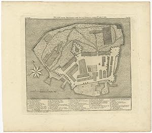
Antique Map of the Island Onrust (near Batavia) by J.W. Heijdt (c.1744)
Published by J.W. Heijdt, 1744
Seller: Bartele Gallery - The Netherlands, Langweer, FRL, Netherlands
Seller rating 5 out of 5 stars
Art / Print / Poster
No Binding. Condition: Good. Antique print titled 'Plan oder Grundris Der Insul Onrust oder Unruhe'. Map of the island of Onrust off the coast of Batavia. Engraved by J.C. Berndt, published by J.W. Heijdt, c.1744. General age-related toning. Please study image carefully. Overall size: 36 x 31 cm. Image size: 25 x 22.5 cm.
-
Antique Map of the Anjol Battery (Batavia) by J.W. Heijdt (1739)
Published by J.W. Heijdt, 1739
Seller: Bartele Gallery - The Netherlands, Langweer, FRL, Netherlands
Seller rating 5 out of 5 stars
Art / Print / Poster
No Binding. Condition: Good. Antique print titled 'Plan oder Grund-Riss der Batterie Anjol'. Engraving of artillery battery of canons �Anjol� as part of the fortifications around Batavia. Overall in good condition, please study image carefully. Engraved by A. Hoffer, published by J.W. Heijdt, 1739. Overall size: 37 x 30.8 cm. Image size: 26.5 x 22 cm.
-
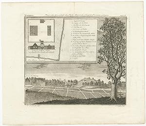
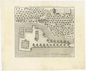
Antique Map of the Maronde trading post near Batavia by J.W. Heijdt (1740)
Published by J.W. Heijdt, 1740
Seller: Bartele Gallery - The Netherlands, Langweer, FRL, Netherlands
Seller rating 5 out of 5 stars
Art / Print / Poster
No Binding. Condition: Good. Antique print titled 'Plan oder Grundriss des Posts Maronde, ohnweit Batavia gelegen'. Map of the Maronde trading post near Batavia. Engraved by A. Hoffer. Published by J.W. Heijdt, 1740. Good condition, please study image carefully. Overall size: 36.8 x 31.5 cm. Image size: 26.3 x 23 cm. The collection of Bartele Gallery includes over 50,000 authentic antique maps, sea charts, prints and books. Our Abebooks store includes a selection of maps, prints and books for SALE prices. Please visit our other online sales channels to explore our complete collection of original antique maps and prints!
-
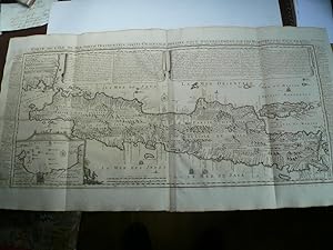
Kein Einband. Condition: Sehr gut. 1. Auflage. Carte de L �Ile de Java. Chatelain, anno 1719, very good condition and authentic map Carte de l'Ile de Java: Partie Occidentale, Partie Orientale, Dressee tout Nouvellement Sur Les Memoires Les Plus Exacts; By: Henri Abraham Chatelain Date: 1719 (published) Amsterdam Dimensions: 47x92 cm. (sheet). This is an authentic antique map of the island of Java showing portion of Sumatra and Bali. The map was produced for Chatelain's VII volume world atlas out of Amsterdam in 1719 This is without question, the most elaborate, and accurate large format map of the Island of Java and its coastline of the early 18th century. The city and port of Batavia (Jakarta) can be found in the northwest portion of the island as well as in a large insert in the lower left portion of the map. Above the map are two drapery style title banners written by Gueudeville, that present the history of the island as well as the presence of the Dutch. Additional text on either side of the map refer to various cities and villages of Java Condition: Map is in very good condition, with wide margins and a strong impression.
-

Antique Map of Batavia, Semarang and Surabaya by Wolters 'circa 1910'
Seller: Bartele Gallery - The Netherlands, Langweer, FRL, Netherlands
Seller rating 5 out of 5 stars
Antique map titled 'Plattegronden van Steden op Java'. Old map with plans of Batavia (Jakarta), Semarang and Surabaya (Soerabaja)'. Published by J.B. Wolters.
-

Antique Map of Batavia and Surabaya by Winkler Prins, 1905
Seller: Bartele Gallery - The Netherlands, Langweer, FRL, Netherlands
Seller rating 5 out of 5 stars
Antique map titled 'Batavia en Soerabaja'. Detailed plan of Batavia (Jakarta) and Soerabaja (Surabaya), Indonesia. The plans include important places like Tandjoeng Priok, Oedjong, Weltevreden, Ngampel, Keta Bang, Goebeng, Koepang, Goen Sari and Wanakrama.
-

Antique Map of the Region of Batavia by Van Schley, c.1750
Seller: Bartele Gallery - The Netherlands, Langweer, FRL, Netherlands
Seller rating 5 out of 5 stars
Antique map titled 'Carte des environs de Batavia - Kaart van de Buitenstreken van Batavia'. Map of the Batavia area (Jakarta) in Indonesia. With cartouche, scale and compass rose. Published circa 1750. Artists and Engravers: Engraved by J. van Schley. Condition: Good, general age related toning; some light staining from handling. Small repaired tears near bottom middle. Please study image carefully. Date: c.1750 Overall size: 33 x 25.5 cm. Image size: 28 x 20.5 cm. We sell original antique maps to collectors, historians, educators and interior decorators all over the world. Our collection includes a wide range of authentic antique maps from the 16th to the 20th centuries. Buying and collecting antique maps is a tradition that goes back hundreds of years. Antique maps have proved a richly rewarding investment over the past decade, thanks to a growing appreciation of their unique historical appeal. Today the decorative qualities of antique maps are widely recognized by interior designers who appreciate their beauty and design flexibility. Depending on the individual map, presentation, and context, a rare or antique map can be modern, traditional, abstract, figurative, serious or whimsical. We offer a wide range of authentic antique maps for any budget.
-

Antique Map of the Old Land of Batavia and FriesLand by Halma, 1718
Seller: Bartele Gallery - The Netherlands, Langweer, FRL, Netherlands
Seller rating 5 out of 5 stars
Antique map Friesland titled 'Descriptio veteris Agri Batavi et Frisii (.)'. Old map of Friesland, the Netherlands. This map depicts the old land of Batavia and Friesland. Originates from 'Uitbeelding van de Heerlijkheid van Friesland' by Bernardus Schotanus � Sterringa. This atlas is considered the best atlas of Friesland, the Netherlands. Artists and Engravers: Published by F. Halma, Leeuwarden. Condition: Fine. General age related toning and occasional light staining from handling. Please study image carefully. Date: 1718 Overall size: 65 x 55 cm. Image size: 59 x 33.5 cm. We sell original antique maps to collectors, historians, educators and interior decorators all over the world. Our collection includes a wide range of authentic antique maps from the 16th to the 20th centuries. Buying and collecting antique maps is a tradition that goes back hundreds of years. Antique maps have proved a richly rewarding investment over the past decade, thanks to a growing appreciation of their unique historical appeal. Today the decorative qualities of antique maps are widely recognized by interior designers who appreciate their beauty and design flexibility. Depending on the individual map, presentation, and context, a rare or antique map can be modern, traditional, abstract, figurative, serious or whimsical. We offer a wide range of authentic antique maps for any budget.
-

Antique Map of the Old Land of Batavia and FriesLand, The Netherlands, 1697
Seller: Bartele Gallery - The Netherlands, Langweer, FRL, Netherlands
Seller rating 5 out of 5 stars
Antique map Friesland titled 'Descriptio veteris Agri Batavi et Frisii (.)'. Old map of Friesland, the Netherlands. Depicts the old land of Batavia and Friesland. This map originates from 'Descriptio secundum antiquos agri Batavi et Frisii (.)' by Menso Alting. Artists and Engravers: Menso Alting (1637-1713), Dutch cartographer and mayor of Groningen. Condition: Good, general age-related toning. Some creasing, blank verso. Please study image carefully. Date: 1697 Overall size: 50.5 x 41 cm. Image size: 42 x 32 cm. We sell original antique maps to collectors, historians, educators and interior decorators all over the world. Our collection includes a wide range of authentic antique maps from the 16th to the 20th centuries. Buying and collecting antique maps is a tradition that goes back hundreds of years. Antique maps have proved a richly rewarding investment over the past decade, thanks to a growing appreciation of their unique historical appeal. Today the decorative qualities of antique maps are widely recognized by interior designers who appreciate their beauty and design flexibility. Depending on the individual map, presentation, and context, a rare or antique map can be modern, traditional, abstract, figurative, serious or whimsical. We offer a wide range of authentic antique maps for any budget.
-

c1682 Large Antique Engraving BATAVIA Map South East Asia (TR1-41)
Seller: Antique Paper Company, ASHFORD, KENT, United Kingdom
Seller rating 3 out of 5 stars

US$ 277.27
US$ 8.08 shipping
Ships from United Kingdom to U.S.A.Quantity: 1 available
Add to basketc1682 BATAVIAA fine original antique engraving published for A Collection of Voyages and Travel by Philip Baldaeus, accompanying The True Exact Description of the Most Celebrated East - India Coast of Malabar and Coromandel and the Island of Ceylond, with all adjacent Countries. Size approx 42cm x 35.5cm including the margins with central fold as issued. Fine later hand colour.Philips Baeldeor FatherPhilippus Baldaeus, (baptized on 24 October 1632andndash; 1671) was a Dutch minister. He went to Jaffnaduring the Dutch period on Ceylonwith an invading Dutch force. As the second European after Abraham Rogerius, in his illustratedDescription of the East Indian Countries of Malabar, Coromandel, Ceylon, etc.he documented the life, language and culture of the Tamil People, living in the north of the island. It was initially published in Dutch and German, while the English translation was published by the Ceylon Government Railway (1960).He wrote much about the religious, civil and domestic conditions of the places he visited and introduced his account of the Hindu mythology. He translated the Lords Prayer of the Tamil language, and although it had mistakes, it was remarkable as the first treatise, printed in Europe of any Indian language.Baldaeus went back to Holland and preached until he died while still a young man.Antique Paper Company are a long established family business selling original antique prints, maps engravings as well as many other paper antiques such as original vintage Decorative Posters, Ephemera, Stamps Postal History, Manuscripts, Antiquarian Books much more. We are always looking to buy and have substantial immediate funds available. We are looking for exceptional single items, better collections, original archives, Atlases, Libraries, accumulations etc and have previously purchased from Major Institutions, Libraries, Collectors, Solicitors many other sources. We are happy to travel almost anywhere in the world for the right opportunities. So please do get in touch if you are considering selling your Antique Paper collectables.
-

Antique Map of the Old Land of Batavia and Friesland by Halma, 1718
Seller: Bartele Gallery - The Netherlands, Langweer, FRL, Netherlands
Seller rating 5 out of 5 stars
Antique map Friesland titled 'Descriptio veteris Agri Batavi et Frisii (.)'. Old map of Friesland, the Netherlands. This map depicts the old land of Batavia and Friesland. Originates from 'Uitbeelding van de Heerlijkheid van Friesland' by Bernardus Schotanus � Sterringa. This atlas is considered the best atlas of Friesland, the Netherlands. Artists and Engravers: Published by F. Halma, Leeuwarden. Condition: Good, general age-related toning. Minor defects and repair on folding line, please study image carefully. Date: 1718 Overall size: 66.5 x 55.5 cm. Image size: 42 x 32 cm. We sell original antique maps to collectors, historians, educators and interior decorators all over the world. Our collection includes a wide range of authentic antique maps from the 16th to the 20th centuries. Buying and collecting antique maps is a tradition that goes back hundreds of years. Antique maps have proved a richly rewarding investment over the past decade, thanks to a growing appreciation of their unique historical appeal. Today the decorative qualities of antique maps are widely recognized by interior designers who appreciate their beauty and design flexibility. Depending on the individual map, presentation, and context, a rare or antique map can be modern, traditional, abstract, figurative, serious or whimsical. We offer a wide range of authentic antique maps for any budget.
-

Antique Map of the Siege of Batavia by Van Schley 'c.1750'
Seller: Bartele Gallery - The Netherlands, Langweer, FRL, Netherlands
Seller rating 5 out of 5 stars
Antique map titled 'Batavia assiec� en 1629 - Batavia 1629 belegerd'. Bird's eye view map of the siege of Batavia in 1629, Jakarta, Indonesia. This print originates from the Dutch edition of Prevost's 'Histoire Generale des Voyages' (Paris 1746-1759). Engraved by J. van Schley.
-

Antique Map of the Old Land of Batavia and Friesland by Halma, 1718
Seller: Bartele Gallery - The Netherlands, Langweer, FRL, Netherlands
Seller rating 5 out of 5 stars
Antique map Friesland titled 'Descriptio veteris Agri Batavi et Frisii (.)'. Old map of Friesland, the Netherlands. This map depicts the old land of Batavia and Friesland. Originates from 'Uitbeelding van de Heerlijkheid van Friesland' by Bernardus Schotanus � Sterringa. This atlas is considered the best atlas of Friesland, the Netherlands. Artists and Engravers: Published by F. Halma, Leeuwarden. Condition: Good, general age-related toning. Minor wear, blank verso. Some large creases and foxing. Please study image carefully. Date: 1718 Overall size: 66 x 55 cm. Image size: 42 x 32 cm. We sell original antique maps to collectors, historians, educators and interior decorators all over the world. Our collection includes a wide range of authentic antique maps from the 16th to the 20th centuries. Buying and collecting antique maps is a tradition that goes back hundreds of years. Antique maps have proved a richly rewarding investment over the past decade, thanks to a growing appreciation of their unique historical appeal. Today the decorative qualities of antique maps are widely recognized by interior designers who appreciate their beauty and design flexibility. Depending on the individual map, presentation, and context, a rare or antique map can be modern, traditional, abstract, figurative, serious or whimsical. We offer a wide range of authentic antique maps for any budget.
-

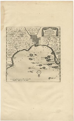
Antique Map of the Bay of Batavia by Van der Aa, c.1720
Seller: Bartele Gallery - The Netherlands, Langweer, FRL, Netherlands
Seller rating 5 out of 5 stars
Antique map titled 'La Rade de Batavia'. A small early 18th century black and white map of the Bay of Batavia (Jakarta), Indonesia. Published by P. van der Aa, circa 1720. Artists and Engravers: Apprenticed at the age of 9, Van der Aa began his career at Leiden in 1683 as a Latin trade publisher, publishing classical texts pertaining to medicine and science. Later on, he became an engraver and publisher of atlases and maps in Leiden. His publications include an ?Atlas Nouveau? completed in about 1710, and the famous La Galerie Agr�able du Monde ? one of the most impressive geographical books printed in 66 volumes in limited edition. It contains around 3000 plates, and cover the topography and people of Europe, Asia, Africa and America. Artist: Apprenticed at the age of 9, Van der Aa began his career at Leiden in 1683 as a Latin trade publisher, publishing classical texts pertaining to medicine and science. Later on, he became an engraver and publisher of atlases and maps in Leiden. His publications include an ?Atlas Nouveau? completed in about 1710, and the famous La Galerie Agr�able du Monde ? one of the most impressive geographical books printed in 66 volumes in limited edition. It contains around 3000 plates, and cover the topography and people of Europe, Asia, Africa and America. Condition: Good, general age-related toning and/or occasional minor defects from handling. Please study scan carefully. Date: c.1720 Overall size: 19.8 x 30.4 cm Image size: 0.001 x 16.1 x 16.2 cm Antique prints have long been appreciated for both their aesthetic and investment value. They were the product of engraved, etched or lithographed plates. These plates were handmade out of wood or metal, which required an incredible level of skill, patience and craftsmanship. Whether you have a house with Victorian furniture or more contemporary decor an old engraving can enhance your living space. We offer a wide range of authentic antique prints for any budget.
-

Antique Map of the Roadstead of Batavia by Van der Aa, 1725
Seller: Bartele Gallery - The Netherlands, Langweer, FRL, Netherlands
Seller rating 5 out of 5 stars
Antique map titled 'La rade de Batavia'. (The roadstead of Batavia.) This map shows the roadstead before the Indonesian city of Batavia, nowadays Jakarta. This plate originates from the very scarse: 'La galerie agreable du monde'. Tome premier des Indes Orientales.', published by P. van der Aa, Leyden, c. 1725. This famous work was published in 66 parts and is the biggest print / map book ever published. Van der Aa incorporated plates by other publishers such as Blaeu, Visscher, de Wit, meurs, Halma, Mortier, Allard in this work and often added broad decorative borders. Probably the costliest and complete universal geographic work ever produced. It is said that only 100 copies were printed. Ref: Koeman Aa9; Phillips 2780 note. Artists and Engravers: Pieter van der Aa (Leiden 1659-1733) was a Dutch publisher best known for preparing maps and atlases. The Galerie Agreable contains plates and maps by the best Dutch engravers: Luiken, Goeree, Mulder, Stoopendaal, ao. Condition: Good, General age related toning and occasional light staining from handling. Paper edge uncut and thus irregular. Original middle fold as issued. Please study image carefully. Date: 1725 Overall size: 49 x 38 cm. Image size: 15.5 x 16 cm. We sell original antique maps to collectors, historians, educators and interior decorators all over the world. Our collection includes a wide range of authentic antique maps from the 16th to the 20th centuries. Buying and collecting antique maps is a tradition that goes back hundreds of years. Antique maps have proved a richly rewarding investment over the past decade, thanks to a growing appreciation of their unique historical appeal. Today the decorative qualities of antique maps are widely recognized by interior designers who appreciate their beauty and design flexibility. Depending on the individual map, presentation, and context, a rare or antique map can be modern, traditional, abstract, figurative, serious or whimsical. We offer a wide range of authentic antique maps for any budget.
-

Antique Map of the Region of Batavia by Conrade, 1782
Seller: Bartele Gallery - The Netherlands, Langweer, FRL, Netherlands
Seller rating 5 out of 5 stars
Antique map titled 'Carte des environs de Batavia.' (Map of Batavia and its surroundings.) Map of the Batavia area (Jakarta) in Indonesia. With cartouche, scale and compass rose. This print originates from 'Batavia, de Hoofdstad van Neerlands O. Indien (.)', 1782. Artists and Engravers: Published by Petrus Conrade and Volkert van der Plaats. Condition: Good, general age related toning; some light staining from handling. Please study image carefully. Date: 1782 Overall size: 44 x 27.5 cm. Image size: 28 x 20.5 cm. We sell original antique maps to collectors, historians, educators and interior decorators all over the world. Our collection includes a wide range of authentic antique maps from the 16th to the 20th centuries. Buying and collecting antique maps is a tradition that goes back hundreds of years. Antique maps have proved a richly rewarding investment over the past decade, thanks to a growing appreciation of their unique historical appeal. Today the decorative qualities of antique maps are widely recognized by interior designers who appreciate their beauty and design flexibility. Depending on the individual map, presentation, and context, a rare or antique map can be modern, traditional, abstract, figurative, serious or whimsical. We offer a wide range of authentic antique maps for any budget.
-

Antique Map of the Islands Near Batavia, Capital of the Dutch East Indies, 1682
Seller: Bartele Gallery - The Netherlands, Langweer, FRL, Netherlands
Seller rating 5 out of 5 stars
Antique map titled 'Caerte van de Eylanden voor Batavia.' Map of the islands near Batavia, Indonesia. With scale, compass rose, cartouche and ships on the sea. Sheet with engraving and text front and rear. This rare original old antique print originates from the book: 'Gedenkweerdige Brasiliaense Zee en Lantreize .' by Johan Nieuhof, published by Jacob van Meurs, Amsterdam, 1682. First and only Dutch edition. Later amended English edition published by Churchill in 1744. Artists and Engravers: Johan / Jan / Johannes Nieuhof / Nieuhoff / Neuhof (1618-1672) was a Dutch traveler who wrote about his journeys to Brazil, China and India. The most famous of these was a trip of 2,400 km from Canton to Peking in 1655-1657, which enabled him to become an authoritative Western writer on China. Johan Nieuhof was born in Uelsen, Germany, of which his father (originally from Zwolle) was mayor. Nieuhof left for Brazil in 1640 as a reserve officer-candidate - from then on, barring two short family visits in 1658 and 1671, he spent all the rest of his life abroad. After an adventurous career in the service of the Dutch East India Company (or VOC) - between 1660 and 1667 he occupied posts in India and on Ceylon - he then lived in Batavia until 1670. He then disappeared without trace on Madagascar, traveling in a sloop from which he had landed to seek drinking water. The engravings are made after Nieuhoff's drawings. Condition: Fine; General age related toning and light staining from handling. Small tears in margin, not effecting image or text. Irregular paper edges. Please study image carefully. Date: 1682 Overall size: 19 x 30 cm. Image size: 17 x 13 cm We sell original antique maps to collectors, historians, educators and interior decorators all over the world. Our collection includes a wide range of authentic antique maps from the 16th to the 20th centuries. Buying and collecting antique maps is a tradition that goes back hundreds of years. Antique maps have proved a richly rewarding investment over the past decade, thanks to a growing appreciation of their unique historical appeal. Today the decorative qualities of antique maps are widely recognized by interior designers who appreciate their beauty and design flexibility. Depending on the individual map, presentation, and context, a rare or antique map can be modern, traditional, abstract, figurative, serious or whimsical. We offer a wide range of authentic antique maps for any budget.
-
Antique Map of Batavia, Jakarta, Indonesia by P. Van Der Aa, 1719
Seller: Bartele Gallery - The Netherlands, Langweer, FRL, Netherlands
Seller rating 5 out of 5 stars
A small early 18th century black and white map of Batavia by the Dutch cartographer Pieter Van Der Aa. This map was first published in his 'Nouvel Atlas (.)' in 1714 as map 156. The map was re-issued in his monumental work entitled 'Galerie Agreable du Monde'.
-

Antique Map of Batavia, Capital of The Dutch East Indies at the Time, 1751
Seller: Bartele Gallery - The Netherlands, Langweer, FRL, Netherlands
Seller rating 5 out of 5 stars
Antique map titled 'Carte von den Gegenden um Batavia .' (Map of Batavia and surroundings.) This print shows a map and a view of Batavia, (Jakarta) Indonesia. With compass rose, cartouche and legend. Ships. This map originates from 'Allgemeine Historie der Reisen zu Wasser und zu Lande (.)', by J. Schwabe, Leipzig 1751. Artists and Engravers: Johann Joachim Schwabe (1714 - 1784), German philosopher, translator and scientist. Condition: Good, general age related toning; some light staining from handling. Please study image carefully. Date: 1751 Overall size: 32 x 24.5 cm. Image size: 28 x 20 cm. We sell original antique maps to collectors, historians, educators and interior decorators all over the world. Our collection includes a wide range of authentic antique maps from the 16th to the 20th centuries. Buying and collecting antique maps is a tradition that goes back hundreds of years. Antique maps have proved a richly rewarding investment over the past decade, thanks to a growing appreciation of their unique historical appeal. Today the decorative qualities of antique maps are widely recognized by interior designers who appreciate their beauty and design flexibility. Depending on the individual map, presentation, and context, a rare or antique map can be modern, traditional, abstract, figurative, serious or whimsical. We offer a wide range of authentic antique maps for any budget.
-

Antique Map of Batavia by Van Schley 'c.1750'
Seller: Bartele Gallery - The Netherlands, Langweer, FRL, Netherlands
Seller rating 5 out of 5 stars
Antique map titled 'Batavia'. Original antique map of Batavia, Jakarta, Indonesia. This print originates from the Dutch edition of Prevost's 'Histoire Generale des Voyages' (Paris 1746-1759). Engraved by J. van Schley.
-

Antique Map of Batavia, Nowadays Jakarta, the Capital of Indonesia, 1782
Seller: Bartele Gallery - The Netherlands, Langweer, FRL, Netherlands
Seller rating 5 out of 5 stars
US$ 1,138.55
US$ 19.78 shipping
Ships from Netherlands to U.S.A.Quantity: 1 available
Add to basketAntique map Batavia titled 'Batavia zo als het was in den Jaare 1731'. Old map of the city of Batavia (Jakarta) in Indonesia. Originates from 'Batavia, de Hoofdstad van Neerlands O. Indien (.)'. Artists and Engravers: Published by Petrus Conrade and Volkert van der Plaats, 1782. Condition: Very good, please study image carefully. Date: 1782 Overall size: 53.5 x 25 cm. Image size: 46.5 x 18 cm. We sell original antique maps to collectors, historians, educators and interior decorators all over the world. Our collection includes a wide range of authentic antique maps from the 16th to the 20th centuries. Buying and collecting antique maps is a tradition that goes back hundreds of years. Antique maps have proved a richly rewarding investment over the past decade, thanks to a growing appreciation of their unique historical appeal. Today the decorative qualities of antique maps are widely recognized by interior designers who appreciate their beauty and design flexibility. Depending on the individual map, presentation, and context, a rare or antique map can be modern, traditional, abstract, figurative, serious or whimsical. We offer a wide range of authentic antique maps for any budget.
-

Antique Map of the City of Batavia by Van der Aa, circa 1730
Seller: Bartele Gallery - The Netherlands, Langweer, FRL, Netherlands
Seller rating 5 out of 5 stars
US$ 1,438.16
US$ 19.78 shipping
Ships from Netherlands to U.S.A.Quantity: 1 available
Add to basketAntique map titled 'Plan de la Ville et du Chateau de Batavia en l'Isle de Iava - Ware affbeeldinge wegens het Casteel ende Stadt Batavia gelegen op groot Eylant Java'. Detailed plan of Batavia / Jakarta, Java, Indonesia. With bird's-eye view from sea side. Two inset keys with detailed description of the buildings. Published by P. van der Aa, circa 1730.
-

Antique Map and Views of Batavia by Homann Heirs, '1733'
Seller: Bartele Gallery - The Netherlands, Langweer, FRL, Netherlands
Seller rating 5 out of 5 stars
US$ 2,996.17
US$ 19.78 shipping
Ships from Netherlands to U.S.A.Quantity: 1 available
Add to basketAntique map titled 'Der Hollaendisch-Ostindianischen Compagnie weltberuhmte Haupt-Handels und Niederlags-Stadt Batavia, in Asien auf dem grossen Eyland Iava in dem konigreich Iacatra nord-westlich gelegen, nach ihrem grund-ris und prospect mit erlauterung einiger ihrer besondersten merkwurdigkeiten / auf das accurateste vorgestellet von Homannischen Erben'. Beautiful plan and views of Batavia, Jakarta, Indonesia. The various types of land use are shown, along with a comprehensive index and a text concerning the history of the city. Along the top, decorative galleons are shown, along with anchorage points. At the bottom is a large view of the fortified city from the water, along with smaller views of VOC Governor General's residence and the town hall. Published by Homann Heirs, 1733. Homann Heirs was a German publishing firm that enjoyed a major place in the European map market throughout the 18th century. Founded in 1702 by Johann Baptist Homann, the business passed to his son, Christoph, upon Johann's death in 1724. Christoph died in 1730, aged only 27, and the firm was inherited by subsequent Homann Heirs. This altered the name of the company, which was known as Homann Erben, or Homann Heirs. The firm continued in business until 1848.
-

Antique Map of Java and Batavia of nowadays Indonesia, '1818'
Seller: Bartele Gallery - The Netherlands, Langweer, FRL, Netherlands
Seller rating 5 out of 5 stars
US$ 1,438.16
US$ 19.78 shipping
Ships from Netherlands to U.S.A.Quantity: 1 available
Add to basketAntique map titled 'Kaart van het Eiland Java'. A rare and attractive early 19th century Dutch map of Java with a large inset map of Batavia. One of 12 maps from 'Atlas van Overzeesche bezittingen' (Atlas of Oversea Possessions) by J.S. van den Bosch. J.S. van den Bosch (1780-1844), Major General, knight of the 3rd class of the Military William order.
-

Antique Map of Batavia, Dutch East Indies, Nowadays Jakarta, Indonesia, ca.1669
Seller: Bartele Gallery - The Netherlands, Langweer, FRL, Netherlands
Seller rating 5 out of 5 stars
US$ 1,617.93
US$ 19.78 shipping
Ships from Netherlands to U.S.A.Quantity: 1 available
Add to basketAntique map titled 'Ware afbeeldinge wegens het Casteel ende Stadt Batavia gelegen opt groot Eylant Java Anno 1679. Plan de la Ville et du Chateau de Batavia en l'Isle de Iava. 1679.' A plan of Batavia, with a bird's eye view from the sea as inset map in the bottom edge. Two indices (French and Dutch) in the lower left and right edges. Arnoldus Montanus' "Gedenkwaerdige Gesantschappen der Oost-Indische Maatschappy in 't Vereenigde Nederland aan de Kaisaren van Japan [?]. Amsterdam: Jacob Meurs, 1669. Artists and Engravers: Made by an anonymous engraver after 'Arnoldus Montanus'. Condition: Good, given age. Original middle fold, as issued. Some small stains in the margins. General age-related toning and/or occasional minor defects from handling. Please study image carefully.
-

Antique Map of Batavia 'Jakarta', Indonesia by Montanus, circa 1669
Seller: Bartele Gallery - The Netherlands, Langweer, FRL, Netherlands
Seller rating 5 out of 5 stars
US$ 1,498.09
US$ 19.78 shipping
Ships from Netherlands to U.S.A.Quantity: 1 available
Add to basketAntique map Batavia titled 'Ware Affbeeldinge wegens het Casteel ende Stadt Batavia'. Antique print of the castle and city of Batavia on the Island of Java'. Rare edition with English subtitles 'Aneract Portatura of the Castle and Citty Batavia, lying on the great Ilant Java Anno 1669. Probably originating from an edition of 'Gedenkwaerdige gesantschappen der Oost-Indische maatschappy in t Vereenigde Nederland (.)' by A. Montanus. Artists and Engravers: Arnoldus Montanus (circa 1625?1683) was a Dutch teacher and author. He published books on theology, history, and geography. Date: circa 1669 Antique prints have long been appreciated for both their aesthetic and investment value. They were the product of engraved, etched or lithographed plates. These plates were handmade out of wood or metal, which required an incredible level of skill, patience and craftsmanship. Whether you have a house with Victorian furniture or more contemporary decor an old engraving can enhance your living space. We offer a wide range of authentic antique prints for any budget.
-

Antique Map of Batavia 'Jakarta, Indonesia', the Dutch East-Indies, 1782
Seller: Bartele Gallery - The Netherlands, Langweer, FRL, Netherlands
Seller rating 5 out of 5 stars
Antique map titled 'Batavia zo als het was in den Jaare 1731.' (Batavia as it was in the year 1731.) Map of the city of Batavia (Jakarta) in Indonesia. With legend and scale. This print originates from 'Batavia, de Hoofdstad van Neerlands O. Indien (.)', 1782. Artists and Engravers: Published by Petrus Conrade and Volkert van der Plaats. Condition: Good, general age related toning; some light staining from handling. Please study image carefully. Date: 1782 Overall size: 54 x 27.5 cm. Image size: 47 x 18 cm. We sell original antique maps to collectors, historians, educators and interior decorators all over the world. Our collection includes a wide range of authentic antique maps from the 16th to the 20th centuries. Buying and collecting antique maps is a tradition that goes back hundreds of years. Antique maps have proved a richly rewarding investment over the past decade, thanks to a growing appreciation of their unique historical appeal. Today the decorative qualities of antique maps are widely recognized by interior designers who appreciate their beauty and design flexibility. Depending on the individual map, presentation, and context, a rare or antique map can be modern, traditional, abstract, figurative, serious or whimsical. We offer a wide range of authentic antique maps for any budget.
-
Antique Map of Batavia 'Jakarta, Indonesia' by Montanus, 1679
Seller: Bartele Gallery - The Netherlands, Langweer, FRL, Netherlands
Seller rating 5 out of 5 stars
US$ 1,276.37
US$ 19.78 shipping
Ships from Netherlands to U.S.A.Quantity: 1 available
Add to basketFine early plan of Batavia (Jakarta), published by Arnoldus Montanus. This map has a vignette at the bottom showing Jakarta from the sea with the volcanoes Mount Gede, Mount Pangrnago and Mount Salak in the background. The plan is based on the earlier, much larger map of Batavia published by Clement de Jonghe in 1650.
-
Large Antique Map of Java & Madura with Batavia Inset, c.1870s Dutch East Indies
Seller: Bartele Gallery - The Netherlands, Langweer, FRL, Netherlands
Seller rating 5 out of 5 stars
US$ 1,677.86
US$ 19.78 shipping
Ships from Netherlands to U.S.A.Quantity: 1 available
Add to basketLarge Antique Map of Java & Madura with Batavia Inset, c.1870s Dutch East Indies This finely detailed 19th-century Dutch colonial map is titled "Java en Madoera op den schaal van 1:600.000", published in Amsterdam by Seyffardt's Boekhandel in the late 19th century, circa 1870s?1880s. The map was produced at a scale of 1:600,000, offering an authoritative overview of the most important island of the Netherlands Indies. The map covers the entire island of Java together with Madura, highlighting towns, residencies, mountain ranges, rivers, and the road network. Relief is expressed through finely engraved hachures, and administrative divisions are outlined with subtle original hand color. In the lower left corner, an important inset plan shows Batavia (modern Jakarta) and its port area, with canals, fortifications, and public buildings carefully named ? a rare and valuable reference to the colonial capital during its 19th-century expansion. Size: approx. 124 � 42 cm (49 � 16� in) when fully opened. Dissected into panels and mounted on original linen, as issued, making it both portable and durable. Condition: Good. Original linen backing with issued folds. Some light toning and minor spotting along folds and intersections, but overall strong and complete. Framing Tips: Due to its long horizontal format, this map works best in a wide landscape-style frame. A black or dark wood frame with a cream or pale grey mat highlights the detail while emphasizing its cartographic presence. Technique: Engraving with original hand color, dissected and mounted on linen Maker: Seyffardt's Boekhandel, Amsterdam, c.1870s --- Collector's Note: Large-scale Dutch colonial maps of Java were indispensable for administrators, traders, and travelers. Seyffardt's edition is especially desirable for its Batavia inset, documenting the colonial capital in fine detail. Surviving examples in good condition are increasingly scarce and sought after by collectors of Indonesia and the Dutch East Indies.